Charlemont FairgRounds Redesign

For the Town of Charlemont, MA
by Amy Furman & Deborah Stone
The Conway School Spring 2024


For the Town of Charlemont, MA
by Amy Furman & Deborah Stone
The Conway School Spring 2024


Set on a beautiful 24-acre parcel of land overlooking the town and the Deerfield River, the Charlemont Fairgrounds have been part of the community of Charlemont since 1871, when the site was founded as an agricultural fairgrounds, whose purpose was to demonstrate the most improved farming and agricultural practices of the time. In 1940, the agricultural fair stopped operating, and the Town bought the land to use for community recreation. Now managed by the Parks and Recreation Department, the site is beloved by the townspeople who visit it to walk, run, bike, and play. The site also hosts a variety of community events, ranging from local tag sales and senior lunches to larger events such as an annual reggae festival that attracts several hundred people.


In September 2022 Charlemont's Parks and Recreation Department received a grant in the amount of $500,000 (to be shared between the Fairgrounds and the local school) to redesign the site for enhanced community use. The Town's overarching goal was to transform the site into a gathering place for the community that could be used year-round, by all ages, with both open and sheltered spaces. The Town also considered whether, with improved facilities,the Fairgrounds could support events of region-wide interest, potentially bringing in more visitors.
At an August 2023 town meeting, residents were asked to share input into what these changes might be, and a preliminary list of possibilities was generated that included upgrading the Exhibit Hall for year-round use, creating a walking path to the Fairgrounds from town, adding seating, improving signage, and adding outdoor recreational facilities (e.g., a pool, splash pad, game area). In the spring of 2024, the Town entered into a collaboration with the Conway School to develop design concepts.
A Core Committee of town staff and volunteers was formed: Liz Bouyea, Michael Hayden, Laurie Merrigan, BonnieJo Radasch, and Sarah Reynolds. Based on their input and data from a town-wide survey distributed in spring 2024, and preliminary site analyses, the following specific goals emerged:
• Improve foot access to the site and improve and clarify pedestrian and vehicle circulation within the site
• Update infrastructure to ensure universally accessible routes between activity areas and buildings
• Define outdoor spaces for community events at differing scales and for different seasons
• Site parking areas for large and small events and daily use
• Implement erosion control as needed
• Enhance vegetation to support wildlife habitat


The town of Charlemont is set in an ecologically rich and unique region. For this reason, it draws people from far and wide to enjoy the rich forested landscape, small mountains, and wide rushing river. It is no surprise that the main industry in the town is outdoor adventure tourism.

Charlemont is a small town (population 1200) in the northeast corner of Massachusetts, of approximately 26 square miles. The town was originally home to the Nipmuc, Potomuc, and Mohican people, prior to the arrival of European settlers in the late 1600's. The Mohawk Trail (also known as Route 2 and designated a "Scenic Byway" by the state of Massachusetts) runs through the center of town and along the extraordinarily beautiful Deerfield River. Charlemont is a destination for outdoor tourism, and throughout the year visitors come to ski, kayak, hike, do ropes courses, mountain bike, and white water raft, with the heaviest tourism in the summer months. In addition to the local outdoor adventure businesses, there are a handful of restaurants and a small general store. Just north of town center, the Fairgrounds is mostly used by local residents, other than for a few larger events once or twice a year.


Ecoregions are geographic areas defined by shared geologic, climatic, and hydrological conditions, and their related plant communities. Charlemont sits within the two ecoregions of the Berkshire Highlands and the Vermont Piedmont. This area tends to have small to medium size mountains, and a mix of northern hardwoods and transition hardwoods with greater presence of oaks. Lower slopes support northern hardwood or mesic red oak-northern hardwood forests, with dominant trees being sugar maple, beech, yellow birch, and northern red oak. Most of these species are found on site at the Fairgrounds and connect the site to the surrounding landscape.


Massachusetts Biomap is a dataset that identifies critical natural landscape elements across the state with the goal of conserving and protecting plants, habitat and wildlife. As the above map shows, Charlemont is surrounded by intact, minimally-developed blocks of landscape, heavily forested areas, and aquatic and other wildlife habitat. While much of the site has been cleared for human use, it does not significantly fragment or disrupt wildlife corridors.

The 24-acre Charlemont Fairgrounds sits on a plateau above town. The property boundaries are almost square, centered between Bald Mountain and Berkshire East. In the valley adjacent to the Deerfield River, Charlemont clusters around Route 2 on the Mohawk Trail.
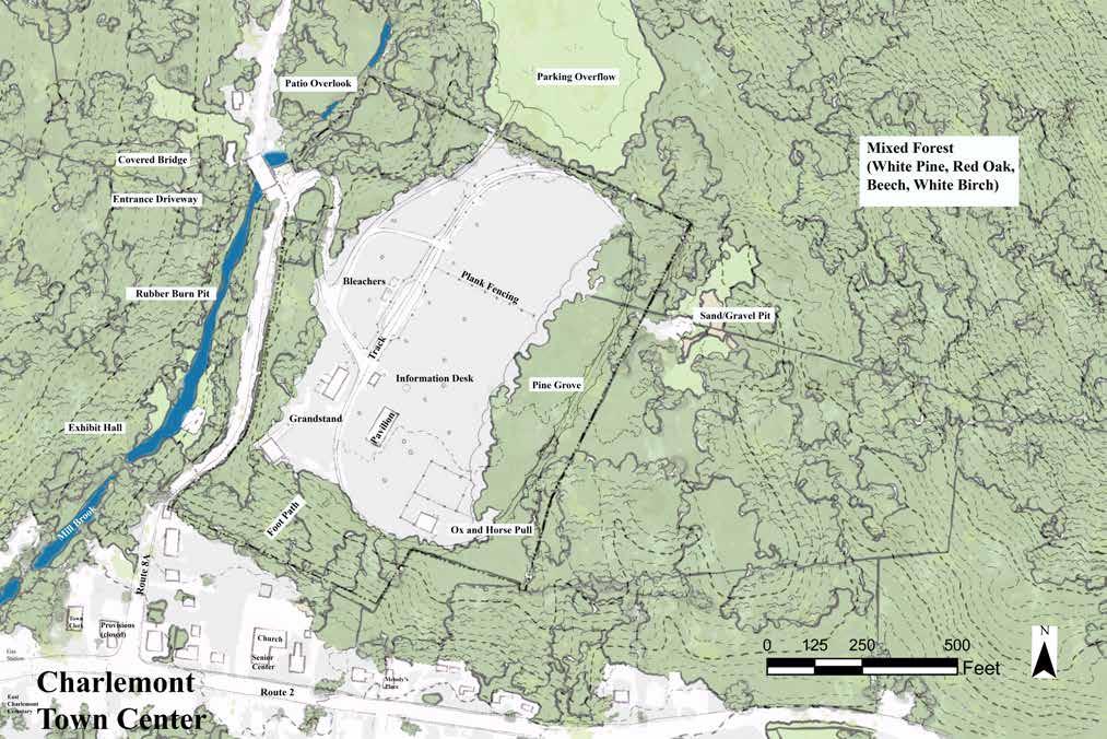
At the intersection of the Fairgrounds' entrance and a covered bridge, a patio offers a beautiful view of the Mill Brook and the recently restored bridge. The steep driveway leads to the top of the hill to a full view of the expansive Fairgrounds. Visitors can park anywhere, with overflow parking located offsite on a neighboring and privately-owned property.
The driveway asphalt ends and transitions to trap rock as visitors enter the Fairgrounds. The oval track, covered in trap rock, measures about one-half mile (500' width x 1000' length) and is exposed to the sun on the west side and shaded on the east side by a grove of white pines. Haircap moss grows on the northern end of the field with various grasses on the southern end. The soil is compacted after 150 years of use.
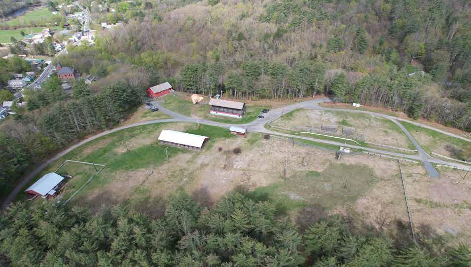
Several buildings line the property's southern end, including an Information Booth, a Pavilion, a Grandstand with attached bathrooms, an Ox/Horse Pull Pavilion, and an Exhibit Hall. The track's west side has a rubber burn pit for the annual car show. Plank fencing scattered around the property is a testament to its history of hosting agricultural events. On the south end a steep footpath through a forest with worn steps, starting from the church parking lot, connects the town to the Fairgrounds. Most people access the site via car.



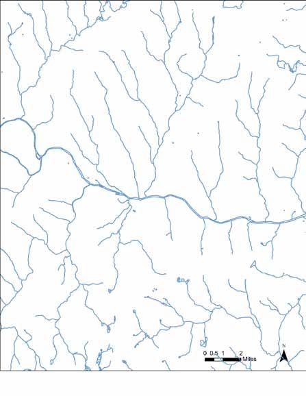
Charlemont is within the 655-square-mile Deerfield River Watershed, which includes about 650 miles of rivers and streams, 50 lakes, and nine major tributaries.
The primarily forested watershed has minimal development. It is home to waterfalls, old-growth forests, and the scenic Mohawk Trail (Route 2).
The Deerfield River flows 70 miles from southern Vermont until it joins the Connecticut River in Greenfield, MA, which flows eventually into the Long Island Sound. Any pollutants in Charlemont stormwater runoff ultimately impact the water quality of the Long Island Sound.
Nonpoint source pollution is a category of pollution which comes from an area rather than a single point (for example, a single pipe). Examples of nonpoint source pollutants are fertilizer, insecticides, herbicides, oil, grease, and other toxic chemicals.
A source of nonpoint pollution in the Deerfield River near Charlemont is the acid mine drainage from the former Davis Mine in Rowe, MA, although it has improved over the years. The Davis Mine Brook empties into the Mill River, a tributary of the Deerfield River.
The Deerfield River is rated in "Good" condition by the EPA, while the Connecticut River and Long Island Sound are both "impaired." The Connecticut River is vulnerable to a variety of pollutants, such as fertilizers, pesticides, road salts, oil, and grease. The Long Island Sound's most problematic issue is too much nitrogen from wastewater treatment plants, septic systems, fossil fuel burning, and fertilizers.


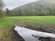
The Fairgrounds' stormwater drains away from the property and towards the Mill Brook and then on to the Deerfield River. There is little pooling around the Fairgrounds. The only noticeable pooling is in areas where vehicles drive off the path.
The northwest corner above the Bissell Bridge patio has a worn swale that has lost its effectiveness. The driveway's swale structure is fractured and filled with sediment. The original material was either asphalt or rock, but it is difficult to identify because of the erosion. Without a functional swale, the stormwater creates multiple paths to the Mill Brook, causing the banks to erode.
Near the Ox/Horse Pull building in the southeast corner, a wet area with a pipe and drain directing water to the south bank is causing severe erosion where the pipe daylights. The erosion will continue to worsen with projected heavier rainstorms due to climate change. Filtering stormwater of pollutants, by vegetation or other methods, and slowing it with, for example, check dams, are essential to maintain healthy and stable forest growth.


The Fairgrounds' soil is predominantly Merrimac, a sandy loam glaciofluvial deposit derived from granite, schist, and gneiss that is strongly acidic. The triangle chart to the left shows sandy loam's clay, sand, and silt amounts. With little clay content, Merrimac retains moisture without becoming waterlogged, but is susceptible to erosion. The depth to restrictive layer is 80 inches leaving plenty of soil for healthy vegetation.




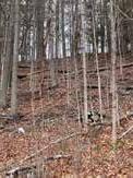
Much of the site is under 5% slope, making it suitable for strollers, wheelchairs, and gathering places. The steep slopes at the edges, particularly on the southern bank where the footpath is, are severe and range from 30 to 50%. The steep slopes make an accessible path (< 5% slope) from town very difficult to build, requiring over 1500 feet of path to navigate the slope, with several switchbacks, on soil that is susceptible to erosion.
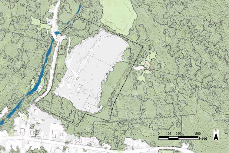
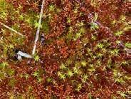
The forest vegetation surrounding the Charlemont Fairgrounds is typical of the area, with many red oak, white pine, sugar maple, birch, and beech trees. Hemlock, striped maple, and basswood are present but in fewer numbers. The forest edge has huckleberry, Virginia creeper, and false lily of the valley in the understory. A white pine grove shelters the east side of the track. The north field is mostly haircap moss, which may indicate nutrientpoor soil conditions. Grass and Quaker ladies spread throughout the remaining southern half of the site.
One goal for the redesign is to define outdoor spaces for community events. Vegetation is a natural way to define spaces and the existing vegetation is an indication of what would have a higher chance of surviving long-term. Volunteers mow the grass as needed, trim dead branches from the white pines, and tend a small perennial garden in front of the Exhibit Hall.
There are five structures on site, clustered in the southern portion of the property. The Fairgrounds site is listed on the Historical Register, although none of the buildings are listed individually. The Exhibit Hall is the only building that is enclosed, and it is used for indoor community events during the warmer months. The other three structures are open air. The Grandstand is in very poor condition and the Town Select Board is deciding whether it can afford to renovate it or must remove it.

The Grandstand was built in 1892 and was used in the past for viewing events on the track. At this time it would require extensive renovation to be safe to use. The bleachers in the Grandstand are oriented toward the space between the track and the Pavilion but spectator events no longer take place there.

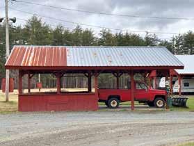
The Information Booth sits at the entrance to the track and is used for equipment storage when there are no events. There are no maps or other materials to help orient nonevent visitors.

An open pavilion offers rental storage space to RVs and other vehicles during the winter months, and is set with picnic tables during the summer.

At the southern end of the site is an open air structure with bleacher seating on one side used for ox and horse pull events–these have not been held over the past several years.


The Exhibit Hall was built in 1885 and remains in use as the main event facility on site. A beautiful space that hosts square dances and other community events, the Exhibit Hall is accessible by a ramp for those with mobility challenges, but is uninsulated and without running water or bathrooms, limiting its usability to the warmer months.
Improving user access is one of the community's main priorities in the Fairgrounds redesign. Currently, the site lacks adequate and universally-accessible bathrooms and seating. The main event facility on site, the Exhibit Hall, is uninsulated and has no running water or bathrooms. The Core Committee has expressed an intention to remedy these conditions as one of the first steps of the project.


There is one set of bathrooms on site at the Fairgrounds, located behind the Grandstand and attached to that structure. The bathrooms were built in the 1950's and renovated about twenty years ago. There is no septic map but according to a local community member with knowledge of the site, the location of the tank and leach field are roughly in front of the women's bathroom in a small loosely fenced area. As the bathrooms are not insulated, the water is turned off in the winter months and the bathrooms are not usable year-round. Survey respondents expressed a strong wish for improved bathrooms. For large events, portable toilets are rented and brought in.


While extraordinarily beautiful, the Exhibit Hall does not currently have insulation, running water, or bathrooms, which restricts its use to the warmer months. Some of the community events that residents expressed a wish for, such as movie nights, could be held year-round in this building if it were insulated and heated.

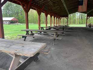
Bleachers in the middle-western portion of the site and picnic tables in the Pavilion offer the only seating at the Fairgrounds. Neither is accessible to those with mobility impairments. Creating accessible seating is another priority identified by the community for the redesign.

The access and circulation analysis examines how people arrive at the site, how well they are able to find their way around the Fairgrounds once they get there, and how they move through the site on foot, in vehicles, and on bikes. Daily patterns of access and use are different from those of larger-scale events. For daily use, most people drive to the site, park, and then walk on the 0.5 mile track which encircles the grounds. The base of the track is trap rock, well-maintained by a small set of dedicated volunteers. About one-third of the path goes through a beautiful shady grove of pines.


The Fairgrounds are primarily accessed by car. Driving from town one heads up Route 8A North and turns into the Fairgrounds just before the covered bridge, up a steep and narrow driveway with a hairpin turn which can be difficult for larger trucks to navigate. A small patio overlooks the Mill Brook on the left as you enter the driveway. Per the Core Committee, people often walk up to the patio overlook from town, although there is no sidewalk along Route 8A. There is no parking at the overlook, and no footpath from the Fairgrounds parking areas down to the overlook patio.
At the top of the driveway, there are multiple directions a car can go, and there is no clear indication of where to park. On any given day, people park in a number of non-specified areas (identified on map at right with the letter "P"). There is no clear sense of arrival, and no signage to clarify parking options or orient visitors to the site.
There is one designated accessible parking space, but the area is on a grassy knoll and would not be easily traversable for someone with mobility challenges, or in a wheelchair. Accessible parking and other facilities have been articulated as a priority for the site redesign by many community members.

While there is a footpath from town to the site (which starts in the parking lot of the Charlemont Federated church), it is steep and eroded and seems little-used. Feedback from the Core Committee and on a town-wide survey indicates that people would like to be able to walk to the site on foot from town, but it is unclear that this is the best option given the sharp change in elevation combined with the erosion.


A 0.5-mile track encircles the site and is much-used by the community for walking, running, biking, and dog-walking. A particularly beautiful section goes through a large stand of pine trees, offering shade, dappled light, and birdsong.
Input into the Fairgrounds redesign project came from three main sources: discussion with members of the Core Committee; a town-wide survey, distributed through email and posted at various locations in town; and a community engagement meeting held at the Fairgrounds on June 1, 2024.


The survey consisted of ten questions that gathered basic demographic information (age, family size, length of time living in town) and asked residents about their current recreational activities, both at the Fairgrounds and in the surrounding areas. Respondents were asked what sorts of events they would like at the Fairgrounds, and what infrastructure they would want to see there. A total of 53 people completed the survey.
While there was a wide range of suggestions for Fairgrounds use and infrastructure, the majority of respondents were interested in more community events: live music, tag sales, fairs, movies, and sports and recreation. The most requested infrastructure was improved bathrooms, seating, and play equipment.
Community Meeting June 1, 2024 On June 1, 2024, fifteen community members gathered in the Exhibit Hall at the Fairgrounds to learn about the design project, listen to a presentation of site analyses completed, and respond to initial design concepts. Attendees participated in a lively conversation about their visions for the Fairgrounds. Some of the topics included what do to with the historical Grandstand, and how the Fairgrounds might generate revenue to pay for its ongoing care.

Residents also reviewed designs, placing stickers on elements that they particularly liked. Overall there was a preference for "improving what we already have" to quote one resident–parking, bathrooms, and upgrading the Exhibit Hall–before adding additional elements. An outdoor covered stage and play structures were also favored.


The Charlemont Fairgrounds are already beloved and extraordinarily beautiful. Elevated above the town and the river, nested in a rich ecological landscape of intact forest and habitat, the site is a treasure in the town of Charlemont and is lovingly maintained as such. The residents of the town want to find ways to use it more, to enhance its functionality, to increase opportunities for the community to gather there, and to preserve and protect it into the future.
There are some basic challenges around access: people want to be able to walk to the site from town, and want the facilities to be accessible to people of all ages and abilities. They would also like to be able to use event spaces year-round. Car and foot circulation and signage can be improved to make arrival and use more clear. And while some areas of the site are nothing short of magical, other areas can feel exposed and uncomfortable.
In thinking about a redesign for the Fairgrounds, essential questions include:
How to balance the desire to preserve existing infrastructure and layout (e.g. space for large car show) with the desire to redesign, improve, and create new elements.
How to support the site’s continued functioning for human use, while enhancing its capacity to support wildlife and connect to the surrounding natural landscape.
How to preserve the openness and majestic scale while making spaces that feel comfortable for human use.
How to preserve flexibility so that spaces can shift between small community events and larger scale events.


· Gorgeous setting, Mill Brook to the west
· Surrounded by forested landscape
· Magical pine stand
· Beloved by community, long history of use
· Dedicated volunteers
· Beautiful views
· Bathrooms and parking not accessible
· Limited foot access from town
· Confusing arrival zone, where to park?
· What to do with the Grandstand
· "Bald spot" – exposed open area with compacted soil and little vegetation
· Limited maintenance resources
· Vast scale

Based upon initial site analyses and input from the Core Committee and town-wide survey, three initial design concepts were developed. While there are elements in all of the designs that overlap, e.g. more delineated parking, improved use facilities, managed erosion, added vegetation, and carved-out clear activity zones, each emphasizes a different set of priorities and is described with an overarching theme. These design concepts were shared with members of the community and their feedback and preferences were incorporated into the final design. Pros and cons of each concept are outlined below.

Design #1, "Event-ful," emphasizes creating event spaces at differing scales across the site. An outdoor stage sits at the northwest corner of the site, with forested mountains as a backdrop. The pine grove is extended to create an arch that wraps behind the audience seating area and creates a sense of enclosure. A large expanse of open lawn is preserved for recreation. The driveway is re-routed to two distinct parking areas. The existing pavilion is moved to define a second outdoor event space at the southern end of the site.

Design #2, "For the Birds," contemplates turning over a large portion of the site to grassland meadow to provide enhanced habitat for local wildlife and birds. The meadow is encircled with a mixed shrub layer (evergreen and deciduous plants) to provide more protection for nesting birds and other wildlife, and is mown only once a year. In the pine grove additional shadetolerant plants and wildflowers increase habitat value while providing a more layered path for walkers, with a labyrinth path on the east edge of the pines that goes through several types of plant communities. A birdwatching platform at the northwest corner invites people to stop and take in the wildlife.
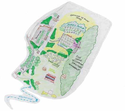
Design #3, "Community Hub," is oriented around daily use of the site by the community, with activities for people of all ages, and an emphasis on family use. A community garden sits in the center and contains a playground for small children. A welcome pavilion at the entrance offers shade and a place to socialize. Under the pine trees a natural playground offers structures for older children and adults to play, climb and explore. A grove of fruit trees and a wild berry patch sit at the northern edge of the food garden offering chances to forage. In the southern part of the site, a pavilion sits in front of a grove of aspen and birch trees for music and other community events.

Pros
¤ Space for small, medium, and large events.
¤ Drivers directed to parking.
¤ Safe foot access from town to the fairgrounds.
¤ More seating and nooks and crannies to picnic or socialize in.
¤ Pines grow quickly for a quick result.
¤ Buildings work together with new siting.
Cons
¤ Requires moving two buildings.
¤ Compost toilets require maintenance.
¤ Long foot path, with steps, from town.
Pros
¤ Provides important habitat for birds and wildlife.
¤ A labyrinth path through a woodland garden, open meadow, and shrubland creates a magical experience for walkers.
¤ Bird observation platform for children and adults to engage with wildlife.
¤ Minimal mowing – grassland can be mown once a year.
¤ Creates enclosure in outdoor area nearest to exhibit hall with shade trees and two pavilions.
Cons
¤ Eliminates option to do large car shows.
¤ Requires community education to teach people about staying out of grasslands during nesting season.
Pros
¤ Community gardens linked to playground for small children.
¤ Natural playground with climbing structures for older kids in pine stand.
¤ Paths can be mown through meadows.
¤ Berry patch and fruit orchard for humans and wildlife.
¤ Re-uses grandstand material for community pavilion for events.
¤ Bathrooms and compost bins conveniently located near parking.
Cons
¤ Eliminates option to do large car shows.
¤ Requires more community engagement and buy-in to make it work.
In the final design for the Fairgrounds, beloved aspects and programming are preserved and enhanced, and new elements enrich and elevate the beauty and usability of the site. The design takes its cues from the natural surroundings. Mountains provide the backdrop for an open-air stage. The design enlarges the magnificent pine grove to encircle this new event space. In the pine grove, a natural playground invites children and adults to explore, climb, and play together. Just as the site is elevated above the town, arriving there lifts the visitors into a magical and immersive experience as soon as they turn into the driveway. Vegetation and other strategic green infrastructure elements promote climate resilience and help to prepare the site to thrive as part of the community into the future. With improvements to basic infrastructure and parking, the site is accessible to users of all ages and ability.
Arrival to the site at the bottom of the driveway and at multiple key spots around the entrance is communicated through large, clear signs, welcoming visitors and clarifying where parking is and where key buildings are located. Locations of signs are shown with a pink asterisk on the map at right. Additional planted beds around the entrance of the Grandstand offer a lovely welcome and also help to shape the flow of circulation.
Booth New signage
The information booth is relocated to the outside of the track so it is seen immediately upon arrival, just adjacent to the main parking area. A large sign relates the history of the Fairgrounds, and a map orients visitors to the main areas and structures of the site. Information about upcoming events is also displayed here.
The seating capacity of the patio overlooking the Mill Brook is expanded from three to twelve, with additional and reconfigured benches. While expanding the patio was explored, the regrading required would be extensive given how the patio is perched on the edge of a steep and eroding bank. Two parking spots are added to the east of the patio and 80 feet up the driveway (see detail on sheet 13).

Driveways, foot access, and parking
Because the existing foot path from town is too steep and eroded, this design includes a sidewalk on Route 8A from town and along the driveway to the site. At the top of the driveway, the road separates and visitors are directed either to the Exhibit Hall and small parking lot to the south, or the main parking lot to the north. The driveway to the Exhibit Hall runs behind the bathrooms along a forested edge and leads to a parking lot with 14 regular spots and
2 ADA-accessible spots. The main parking lot sits just to the north, and is delineated with new trees that add structure and shade and help manage runoff from car parking. This parking lot has 125 regular spots and 4 ADA-accessible spots. Driveway and parking lots have a trap rock surface.
A covered stage is sited at the northwest corner of the site, with the backdrop of Bald Mountain in the distance. The structure is 20 x 30 feet and has a roof and elevated platform stage (see Sheet 15). The stand of pine trees is extended from the existing grove to form an arc, creating a sense of enclosure within the newly defined event lawn.
Natural playground structures are added throughout the pine stand. These structures are made of wood and other natural materials, and include large rocks, stumps, and climbing structures that can be used by children and adults. A set of play equipment oriented toward smaller children is sited closer to the event lawn, so that parents can keep an eye on young children while they attend events.

Additional shrub borders and wildflower beds enhance the area around the Exhibit Hall and help to define the parking area there. New trees line the main parking lot, defining the space. The pine grove is extended to create a semi-circular event lawn in front of the open air stage, and a shrub edge is added between the pine grove and lawn. Rain gardens are sited at the back of the Ox/Horse Pull to manage runoff and erosion in that area. All of this vegetation increases habitat value on site and helps to manage stormwater.
Rain gardens, new trees, and shrub layers help retain stormwater on site. To prevent further erosion on steep banks around the edges of the property, check dams are added at the top of the bank behind the Ox/Horse Pull. From the patio to the top of the driveway, a swale is added to manage stormwater runoff from the Fairgrounds, reduce erosion, and direct overflow into the Mill Brook.
Given the strong interest expressed by the Core Committee in upgrading the Exhibit Hall with insulation, running water, and accessible bathrooms for year-round use, this design acknowledges their interest and assumes the upgrades will happen. The existing bathrooms are renovated and ADAcompliant. Two waterless toilets are added in the northwest corner of the site.
There are two distinct parking areas in the proposed redesign. As visitors arrive at the top of the driveway, the driveway ends at a T, and visitors can go left to the parking lot to the north, or right to the parking lot to the south that is located in front of the Exhibit Hall. The driveway no longer continues forward directly onto the track; a segment of it is replaced with vegetation and a footpath. The driveway and foot paths have a trap rock surface.

Foot path to track and stage area

• The large lot provides 129 parking spaces, including four accessible parking spaces. The four accessible spots are in the southeast corner, closest to the track.
• Three car entrances/exits and four foot paths provide multiple points of access to and from the lot.
• New 5% grading drains stormwater to the lot's center where black gum trees absorb the water. Black gum trees are adaptive and can tolerate both wet and dry conditions.
• The parking area is defined by chokeberry and inkberry shrubs to the east and west respectively. Red oaks, beech, and aspen line the south end, creating a beautiful entrance to the Fairgrounds. A blue lupine field edges the lot's northern boundary.

• In the southwestern corner of the site is a second parking lot, in front of the Exhibit Hall. This parking lot has 16 parking spaces, across four small sections, two of which are ADA accessible and located near the ramp to the building. There is also a pull-off area near the ramp, so that cars can drop people off at the end of the ramp.
• The driveway to this parking lot runs behind the Grandstand, and is lined with trees and shrubs that frame the road and direct drivers. The driveway then circles around a center planted area which contains a grove of birch trees, and in front of them to the south, a perennial wildflower garden with lowmaintenance, deer-resistant, and rabbit-resistant flowers selected to provide blooms in three seasons (see Plant List, Sheet 19) .
• A four-foot-wide walking path is sited around the edge of the four distinct parking areas so that visitors can get out of their cars and access the track without walking back into traffic.
• A border of shrubs at the front of each parking area helps to frame the spaces and add greenery. Shrub beds are also scattered around the Grandstand, with paths leading to the bathrooms from multiple directions.


• A new sidewalk extends from Route 8A to the top of the driveway, providing safe foot access to the Fairgrounds. A crosswalk at the entrance guides visitors on foot to the sidewalk on the patio side of the driveway.
• One accessible parking space and two regularly-sized spots are at the top of the patio and mid-way up the driveway respectively, eliminating the need for patio visitors to park on the road.
• An accessible path (slope < 8.31%) with a railing leads visitors from the accessible parking spot down to the patio.
• Four benches added to the patio provide seating for nine more visitors.
• American holly bordered by New Jersey tea replaces the grass in the lower patio area. Azaleas line the northern side of the accessible path and a dogwood surrounded by wintergreen sits east of the path.
• A rock swale and culvert guide stormwater from the Fairgrounds to Mill Brook, preventing further erosion to the driveway's edges. The swale extending from the two parking spaces to the top of the driveway is lined with a rock retaining wall to stabilize the adjacent hill.

At the northwestern edge of the property, just inside the track, an open-air stage offers space for music and theater, and can also be rented for weddings, graduations, and other events. The pine grove is extended to form an arch that encircles the lawn where spectators can sit, relax and play, facing the stage with Bald Mountain as a dramatic backdrop. The stage is 20' x 30' with a simple platform base.


Throughout the grove of pines along the eastern edge of the site, natural play structures offer children and adults opportunities to climb and explore. Some simple climbing structures could be built by volunteers.


A set of playground structures oriented toward smaller children is sited at the back edge of the event lawn, so that children can play nearby while adults enjoy events.
The earth's temperature is rising. The northeast United States has experienced an increase in annual temperatures of 1.6°F over the last century and future climate projections show continued warming over the next century across the entire region. Heatwave intensity, frequency, and duration are expected to increase. Precipitation is also increasing: regional annual precipitation amounts have increased at a rate of over 1 inch per decade since the late 1800s, and are projected to continue to increase due to rain events that are both more intense and also longer in duration. At the same time, periods of more intense drought are also expected. More extreme temperatures along with changes in precipitation will also affect rivers, threatening aquatic and other wildlife habitat (Massachusetts Climate Adaptation Partnership. 2015. Massachusetts Wildlife Climate Action Tool).
In 2017, as part of a statewide effort to identify and address regional vulnerabilities related to climate change, the Town of Charlemont developed a Municipal Vulnerability Preparedness Resiliency Plan. The top concerns identified include: key Town infrastructure is located in the 100-year floodplain, including the Fire Department, Highway Department, Police Department, Wastewater Treatment Plant, and the Hawlemont School; increased periods of drought raise the risk of wildfire in a town that is 84% forested; the Town lacks a municipal drinking water source and private wells are subject to flooding and failure during power outages and clean water may become unavailable; and the unreliability of cell and internet service in this rural area also could impact the safety of vulnerable or isolated populations during emergencies.
With solar panels, composting toilets, native vegetation and green infrastructure to manage stormwater, the Fairgrounds could become a model of climate preparedness, inspiring others to learn about how to care for the natural world in the face of changing climate. The town could consider hosting educational events about climate preparedness, and potentially build a community of residents connected by a determination to protect not only the Fairgrounds and the town, but also to help protect the planet itself. While many initiatives and efforts are needed to address these serious and imminent threats to the well-being of the Charlemont community–human and wildlife– the Fairgrounds has the potential to play a role.
Large areas of lawn contribute to climate change in a number of ways. Mowing typically relies on fossil-fuel-powered machines, and contributes to air pollution. Further, lawn is not as permeable as other vegetation is, and does not do a good job of absorbing or infiltrating water. Decreasing the amount of lawn (while preserving some for sitting, walking, and playing), and adding other green infrastructure in the form of trees, shrubs, and native perennials, promotes climate resilience by slowing and sinking stormwater, stabilizing soils, and not requiring frequent mowing. Trees store carbon, and native trees, shrubs, and flowers provide habitat for native wildlife.


Increased frequency and intensity of storms can lead to stormwater that moves too quickly and doesn't have a chance to be absorbed by soil and plants. Because plants help to clean and filter water, this means that the water flowing down from the Fairgrounds and to the Deerfield River, and ultimately to the Connecticut River and the Long Island Sound, will be less clean. Additionally, water rushing down the steep slopes of the Fairgrounds will lead to erosion. There are a number of strategies for slowing and cleaning stormwater.
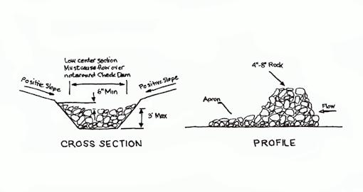
Rain gardens are depressed beds planted with vegetation that infiltrate stormwater, filtering pollution and contaminants, and that also tolerate periods of drought. These planted beds are placed near runoff areas to stop or slow the flow of water. In this design, rain gardens are planted in the southeast corner of the site, behind the Ox/Horse pull area. Check dams made of river rock or other stone are sited within swales to slow, detain, and infiltrate runoff on slopes.
The maximum height of the check dam should not exceed 3 feet. The midpoint of the check dam should be 6 inches lower than the sides for the stormwater to pass through the center rather than around the sides. The bottom of the upstream dam should be at the same level as the top of the downstream dam. Side slopes should be at least 2:1, run to rise.
Use 4-to-8-inch diameter rocks underlain with filter fabric. A 6-inch apron, two times the height of the dam, should be constructed immediately downstream of the check dam to prevent erosion.
Given that the Fairgrounds is a large open space with plenty of sunshine throughout the day on much of the site, it is well-suited to generate solar power. The pavilion in the southern part of the site offers a large expanse of roof (each side of the roof is approximately 100'x 24'). Consultation with solar providers would help to clarify the best precise location and orientation to maximize solar energy capture.

The Core Committee and many residents have expressed a wish that the historic Exhibit Hall be renovated so that it could be used year-round for community events. This would require adding insulation, bringing water lines to the building, adding bathrooms, and providing for heating and cooling. If a cooling system were put in place, the Exhibit Hall could function as a community cooling center for seniors and other vulnerable populations as the number of days of extreme heat continues to increase over the next several decades. The building could also act as respite or refuge from flooding events, or as a designated gathering space if communication networks go down.
The site redesign contemplates a renovation of the existing bathrooms to make the toilets and sinks accessible, as well as creating an accessible path leading to the bathrooms. It is also recommended that the town conduct a survey and assessment of the septic system and leach field, since no maps currently exist. It is important to know the size and status of the existing septic infrastructure as the town contemplates enhancing the Fairgrounds for more community use.
In addition, the site redesign includes a set of waterless toilets at the northwestern corner of the property. These toilets are being used more frequently at public parks and sites, and do not require septic systems, water, or electricity to function. Thus they are an environmentally friendly alternative to adding conventional bathrooms to the site.
Waterless toilets use urine diversion and the natural processes of decomposition and evaporation to breakdown and reduce the volume of human waste. Urine (which is generally sterile) could be carried to storage containers to be diluted and used as fertilizer or discharged directly into the ground via a shallow soak pit. Waste gets broken down into fertilizer either through anaerobic or aerobic decomposition, depending on the type of toilet. Toilets can be equipped with a ventilation fan that can be plugged in to a regular 120V outlet to eliminate any odor.


The below costs are very rough estimates, and are all calculated as 'installed' costs, meaning including labor. Thus, many of the costs outlined would be reduced if volunteer labor were used, or if materials were donated.

Type Common Name
Tree Eastern White Pine Pinus strobus 60'-90' 25'-40' Average Sun/Part Shade
Tree Sassafras Sassafras albidum 20'-40' 8'-18' Average Sun/Part Shade
Host, Songbirds, Wildlife
Host, Songbirds, Bees
Shrub Elderberry Sambucus nigra 5'-8' 3'-8' Wet Part Shade Spring/Summer Fruit Host, Songbirds, Bees, Butterflies
Shrub Lowbush Blueberry Vaccinium angustifolium 1'-2' 1'-3' Average Sun/Part Shade Spring/Summer Fruit Pollinator Powerhouse* Shrub Huckleberry Gaylussacia baccata 1'-3' 2'-3' Average Adaptable Spring/Summer Fruit Host, Songbirds, Bees, Wildlife Groundcover Wintergreen Gaultheria procumbens 1"-4" 6"-12" Average Part Shade/Shade Summer/Winter Fruit Bees
Type
Name
Tree Black Gum Nyssa sylvatica 30'-60' 20'-35' Average Sun/Part Shade Spring
Host, Songbirds
Tree Red Oak Quercus rubra 60'-80' 30'-45' Average Sun/Part Shade Fall/Winter Fruit Host, Songbirds
Tree Pin Oak Quercus palustris 50-70' 40-60' Average/Wet Sun/Part Shade Fall foliage
Tree Aspen Populus tremuloides 25'-50' 15'-25' Average Sun/Part Shade Host, Songbirds Shrub Chokeberry Aronia arbutifolia 5'-12' 4'-8' Average Sun/Part Shade Spring/Summer Fruit Host, Songbirds, Bees
Shrub Inkberry Ilex glabra 3'-6' 3'-5' Average Sun/Part Shade Spring/SumFallWin Fruit Host, Songbirds, Bees, Wildlife Perennial Blue Lupine Lupinus perennis 12"-24" 8"-12" Average Sun/Part Shade Spring/Summer Host, Bees, Butterflies
Groundcover Green and Gold Chrysogonum virginianum 10-12" 10-12" Average Sun/Part Shade Spring
Type
Soil Moisture Exposure Bloom Time Wildlife
Tree Red Oak Quercus Rubra 60-80' 30-45' Average/Wet Sun/Part Shade Fall Pollinator Powerhouse*
Tree River Birch Betula nigra 25-45' 15-25' Average/Wet Sun/Part Shade Fall foliage
Shrub Gro Low Sumac Rhus aromatica 'Gro-low' 2.5-2' 6'-8' Average Sun/Part Shade Spring
Pollinator Powerhouse*
Birds, Butterflies
Shrub Juniper Juniperus communis 12"-16" 3'-4' Average Sun Fall fruit/Evergreen Songbirds
Shrub Pagoda Dogwood Swida Alternifolia 10-20' 6-15" Average/Dry Sun/Part Share Spring/Summer
Perennial Red Columbine Aquilegia Canadensis 8-24" 8-12" Average/Dry Sun Spring
Perennial Wild Geranium Geranium Maculatum 12-18" 8-12" Average/Wet Sun/Part Shade Spring/Summer
Perennial Sundial Lupine Lupinus Perennis 12-24" 8-12" Average/Dry Sun/Part Shade Spring
Perennial Butterfly Milkweed Asclepias Tuberosa 12-30" 12-24" Average/Dry Sun Summer
Perennial Common Milkweed Asclepias Syriaca 24-42" 36-60" Average/Dry Sun/Part Shade Summer
Perennial Wild Bergamot Monarda Fistulosa 24-42" 12-18" Average Sun/Part Shade Summer
Perennial Wild Senna Senna hebecarpa 4-6' 4-6" Average/Dry Sun/Part Shade Summer
Perennial Coastal Plain Joe Pye Eutrochium dubium 3-4" 2-4" Average/Wet Sun Fall
Perennial White Wood Aster Eurybia divaricata 12-24" 12-18" Average/Dry Sun/Part Shade/Shade Fall
Perennial Downy Goldenrod Solidago puberula 12-36" 12-24" Average/Dry Sun/Part Shade Fall
Pollinator Powerhouse*
Butterflies, Hummingbirds, Bees
Pollinator Powerhouse*
Pollinator Powerhouse*
Butterflies, Bees
Butterflies, Bees
Hummingbirds, Bees, Butterflies, Songbirds
Butterflies, Bees, Songbirds
Butterflies, Bees
Pollinator Powerhouse*
Pollinator Powerhouse* Groundcover Green and Gold Chrysogonum virginianum 10-12" 10-12" Average Sun/Part Shade Spring
Tree Sweetbay Magnolia Magnolia virginiana 10'-20' 8'-15' Average Sun/Part Shade Spring Host, Bees
Tree Dogwood Cornus florida 15'-30' 15'-30' Average Sun/Part Shade Spring
Birds, Butterflies
Tree American Holly Ilex opaca 12-30' 8-14' Average Sun/Part Shade Spring Bloom/Summer Fruit/Evergreen Host, Bees,Wildlife
Shrub New Jersey Tea Ceanothus americanus 2'-3' 2'-3' Dry Sun Summer Host, Bees, Butterflies Groundcover Green and Gold Chrysogonum virginianum 10-12" 10-12" Average Sun/Part Shade Spring
Shrub Arrowwood Viburnum dentatum 6'-10' 6'-10' Med/Wet Sun/Part Shade May-Jun
Shrub Sweet Pepperbush Clethra alnifolia 'Ruby Spice' 4'-6' 3'-5' Med/Wet Sun/Part Shade Jul-Aug
Sedge Common Rush Juncus effusus 2'-4' 2'-4' Wet Sun Jun-Aug
Pollinator Powerhouse*
Butterflies
Grass Little Bluestem Schizachyrium scoparium 12-48" 8-24" Dry/Average Sun/Part Shade Fall foliage Host
Perennial Foam Flower Tiarella cordifolia 0.75'-1' 1'-2' Med Shade May
Perennial Moss Phlox Phlox subulata 0.5' 1'-1.5' Med Sun/Part

