D.W. Field Park North : Design Concepts


At more than 700 acres, D,W. Field Park is one of the largest and most highly used city parks in Southeastern Massachusetts. Located just 20 miles south of Boston, it is an important resource for not only the residents of Brockton and Avon in which it is located, but for the surrounding suburban communities as well. The park includes seven water bodies, lawns for picnicking, walking paths, and six miles of paved roads shared by vehicles and pedestrians. Founded by Daniel Waldo Field in the 1930s, and designed as a place to enjoy a scenic drive, today the park is a well-loved space for walkers, runners, bikers, fishermen, nature lovers, and picnickers alike. Its roads are still open to vehicle traffic during certain hours of the day, but the car-centric design and the lack of major renovations since its establishment has led to degraded roadways, erosion, and water quality issues as well as concerns about users’ safety and access.
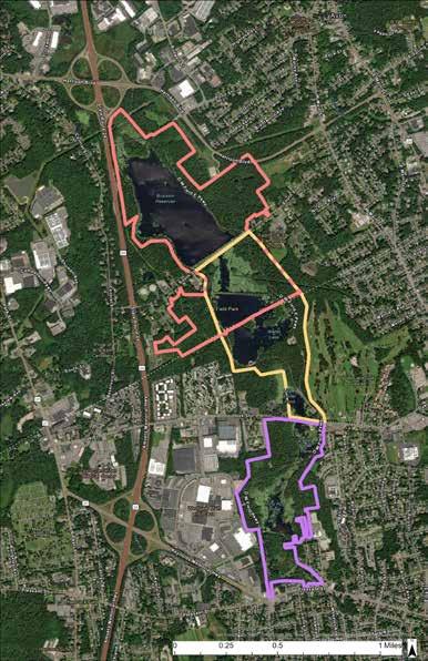
The D.W. Field Park Initiative was launched in 2022 by a local land trust, Wildlands Trust, with the help of an anonymous funder, the Massachusetts Department of Conservation and Recreation, and Planet Subaru. In an effort to restore and revitalize the park and its natural communities, the Initiative “aims to develop a shared vision for the park among park users, Brockton and Avon governments, and the greater community” (dwfieldparkinitiative.org). The D.W. Field Park Initiative is a multi-year project with three distinct phases. Conceptual designs for the first phase, which examined the middle section of the park, were completed in Spring 2023 with a corresponding master plan produced in the spring of 2024. In this second phase, the Conway School is partnering with Wildlands Trust, the City of Brockton, and the Town of Avon to produce conceptual designs for four focus areas in the northernmost portion of the park. The project area for Phase 2 includes approximately 308 acres from Old Pond Street to just south of the causeway on Waldo Lake. Phase 3 will follow this year’s work and will examine the southernmost portion of the park.
The Initiative has established a set of overarching goals that apply to its vision of restoring and revitalizing the park for all, though the immediate goals for each phase of the project vary slightly depending on the areas of focus and need in each region of the park.
Design goals for Phase 2 of this project include:
• A park with safe and accessible roads, pathways, and parking lots that help manage stormwater.
• A landscape that provides wildlife habitat, protects water quality, and is resilient to climate change.
• A space that provides opportunities for physical and mental health and includes upgraded amenities.

In addition to the partnership between The Conway School and Wildlands Trust, the City of Brockton, and the Town of Avon, there are many other important project partners that are helping move this multi-phase initiative forward. Other partners include Old Colony Planning Council, the Center for Resilient Metro-Regions, D.W. Field Park Association, Environmental Partners, Manomet Conservation Sciences, and the Fuller Craft Museum.


The approximately 308-acre project area of Phase 2 of the D.W. Field Park Initiative includes Brockton Reservoir (a source of drinking water for Brockton until 2020), and the northern half of Waldo Lake. These water bodies are surrounded by D.W. Field Parkway, a deteriorating asphalt road that provides views of the water at most points. Along South Street, a busy cross street, the 1800 foot Brockton Reservoir Dam separates the two water bodies and restricts views to the north. A gravel walking path is located on top of this earthen dam, spanning the entire length of it.
Swaths of forest and wetlands border the parkway in many areas, providing wildlife habitat, capturing and breaking down pollutants, and buffering the noise of nearby roads. A habitat assessment performed by Manomet Conservation Sciences characterized forests in the park as a mixture of white pine and red oak uplands and red maple lowlands (5-6). These wooded areas contain many surviving examples of the American chestnut (Castanea dentata). The assessment also observed “[t]he collective presence of Pileated Woodpecker (Dryocopus pileatus), Wood Thrush (Hylocichla mustelina) and Eastern WoodPewee (Contopus virens),” adding that the park is the only known Pileated Woodpecker habitat in Brockton (8).

Residential neighborhoods lie just beyond the project area to the south, east, and west, composed of a mixture of single and multi-family homes. A major highway, Route 24, runs along the western park boundary, and is flanked by commercial and industrial districts north of the park. A cloverleaf of exits and on ramps to Route 24 cuts across the wetlands north of Brockton Reservoir.


Along with site analyses for the entire Phase 2 project area (approximately 308 acres), this plan set provides conceptual designs for four focus areas: Old Pond Street (A), the elevated walking path along the Brockton Reservoir Dam (B), the intersection of South Street and D.W. Field Parkway east (C), and a newly acquired 30-acre parcel west of Waldo Lake (D). These focus areas were identified by the clients for their limited accessibility, opportunities for green infrastructure, and safety and stormwater runoff concerns.

Old Pond Street separates Brockton Reservoir from wetlands to the north. The roadway is eroding due to poor drainage, and two informal parking areas, on the eastern and western ends of the road, cause potential access and circulation issues.


D.W. Field Park is an important natural, historical, and cultural resource for the more than 115,000 people living in Brockton and Avon, as well as for residents of the surrounding towns of Southeastern Massachusetts. Situated among the suburbs of Boston, the park is listed on the National Register of Historic Places, hosts weekly kids races and other community events, and provides one of the largest tracts of contiguous open space in the region. However, the forests and wetlands of D.W. Field Park make up a relatively isolated natural landscape between the neighborhoods of Brockton and Avon to the east, Route 24 to the west, and commercial and industrial districts to the north and south.

Avon and Brockton are composed primarily of single-family neighborhoods, though around the park and throughout both downtowns higher rates of multifamily housing are present. A Community Park Needs Survey conducted by the D.W. Field Park Initiative in 2023 determined that 78% of visitors travel to the park by car, while 11% walk in, and 4% bike in. In Brockton, the farthest a resident would have to travel to the park is four miles, and much of Main Street is within two miles to a park entrance. In Avon, all of the town is within two miles to a park entrance, a relatively easy commute for a biker. The proximity of much of Brockton and Avon to the park provides opportunities for expanded trail systems, access points, or biking infrastructure to encourage less vehicle traffic to and from the park. Cutting down on vehicle usage could in turn reduce greenhouse gas emissions and potentially improve pedestrian safety and water quality at the park.

All of Avon and Brockton are considered environmental justice populations according to Massachusetts’ Executive Office of Energy and Environmental Affairs. Populations are designated as such if they meet one or more of the criteria listed below. This legislation directs state agencies to include EJ populations in decision-making processes when creating new policies or projects. Hearing from members of these communities throughout the design process helps ensure that changes to the park reflect their desires and needs.
• The annual median household income is not more than 65% of the statewide annual median household income
• Minorities comprise 40% or more of the population
• 25% or more of households lack English language proficiency
• Minorities comprise 25% or more of the population and the annual median household income of the municipality in which the neighborhood is located does not exceed 150% of the statewide annual median household income.

D.W. Field Park serves a multitude of people across Southeastern MA with different nationalities, many with limited English proficiency. In the Community Park Needs Survey, respondents listed English, Cape Verdean Creole, Spanish, Haitian Creole, Portuguese, French, and Other as languages spoken at home. When designing signage for the park, including various languages or universal symbols and images may make the park more accessible and user friendly to different user groups.

Two community engagement events were held at the park to better understand how the community uses the space, where they would like to see improvements, and their thoughts on preliminary design ideas.
The first event took place on April 26, 2024. It was a sunny spring Friday, and the Conway team tabled at the intersection of South Street and D.W. Parkway east from 9:00 a.m. to 12:00 p.m. to catch the morning walkers and joggers who use the park before the gates are opened. In the afternoon, the Conway team tabled at the triangle on Old Pond Street. In both locations, people were asked how often they visited the park, how they get there, where they park, if they have trouble finding parking, how they spend their time there, if they are interested in seeing more forested trails, how they feel about vehicle traffic around Brockton Reservoir, and what improvements or additional activities they would like to see. Fourteen participants took the survey, most of whom were on a walk through the park.
The majority of the participants we spoke with visited the park at least twice a week to walk, sit, fish, or enjoy the scenery, and expressed a great deal of interest in seeing the park revitalized. While the majority of users we spoke with got to the park by driving, only a few of them had trouble finding parking on weekdays; some users noted that parking can be more difficult to find on weekends or during the summer. Improvements users wanted to see included better road conditions, decreased speed of drivers, increased signage, playgrounds or activities for kids, and more bathrooms and trash/recycling cans with better maintenance.
When asked whether or not the roads around Brockton Reservoir should be closed to vehicle traffic, about half of respondents said yes because they believed it would make the road safer for walkers and would reduce litter. The half of respondents who preferred to keep drivers on the roads expressed that they use the roads as cut throughs, enjoy being able to drive them to see the winter scenery, and even requested that gates be open earlier so that they can park wherever they choose at all hours of the day.

"My daughter and I come here to exercise and sometimes use tree limbs for pull ups, a workout section would be nice"
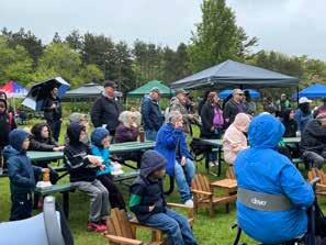
During the second community engagement event on Sunday, May 19, the Conway team tabled at the “Give a Hoot for the Park” event organized by the D.W. Field Park Initiative. Despite it being a gray and rainy day, about 200 people came out to see a live owl demonstration, enjoy a free meal, and interact with a number of different community groups who were tabling. At this event, we shared one preliminary design for the elevated walking path on the Brockton Reservoir Dam and gathered input about how people navigate the intersection of South Street and D.W. Field Parkway east. More than one participant expressed a desire for increased safety at this intersection through measures such as crosswalks with flashing lights, high visibility signage, and other traffic calming devices. Community members also recommended increased signage to discourage people from feeding the ducks and geese, to alert drivers that they are entering a park, and to clearly delineate parking areas.
An interesting take away from both events was users’ perception of safety in certain parts of the park. Some respondents to the survey on April 26th said that they might feel unsafe using forested trails if they can’t see or hear the road. Likewise, women at the “Give a Hoot for the Park” event expressed their concerns for safety when traveling on Old Pond Street because of the lack of users on the far north end of the park. In addition, many users noted feeling unsafe sharing a road with vehicles, and believed that the conditions of the roads increase this feeling as cars swerve in and out of the pedestrian lane to avoid potholes. This idea of safety, whether perceived or physical, is an important one to consider as we move through the design process.
"Ask what the benefit of having the road is, not what would be missing without it"
"I come for a drive here everyday so that my kid can take a nap"

"We need more control on speed from drivers"


Workout Section
Improved Landscaping
Responses to the question “What would improve your experience at the park?” overwhelmingly point to safety concerns of pedestrians sharing park roads with vehicle traffic. Ideas for how to address this issue ranged from traffic calming techniques to separation of vehicles and pedestrians.
One environmental challenge that disproportionately affects environmental justice populations is a high heat index in or near residential areas. This is often due in part to historical patterns of marginalization such as segregation and redlining as well as the persistence of structural racism in the present.
A heat index is defined by CAPA (Climate, Adaptation, Planning, Analytics) Strategies as “an approximation of the heat felt when the presence of humidity is felt in combination with temperature.” Climate change predictions indicate rising temperatures for this region, and, according to CAPA Strategies, “as temperatures rise, the hottest places are likely to remain the hottest.” People living in historically disinvested neighborhoods with limited access to resources and green space or with pre-existing health conditions are at a much higher risk than the general population to experience extreme heat side effects such as heat exhaustion or even death.

The Environmental Protection Agency (EPA) defines urban heat islands (UHI) as occurring “when cities replace natural land cover with dense concentrations of pavement, buildings, and other surfaces that absorb and retain heat.” In a region with such a high percentage of impervious surface, D.W. Field Park is a haven for escaping the heat in the hot summer months.
CAPA Strategies developed an urban heat mapping campaign to collect heat data in areas experiencing environmental and social injustices. Volunteers from each community are trained to collect data, which is then used to create heat maps of the community and shared in a Heat Watch Report. In the maps produced for Brockton and Avon, the temperature ranges across the city and town are striking. The highest temperatures are consistently shown in Brockton’s downtown, corresponding with the highest density of multi-family housing and environmental justice blocks that meet two or more of the MA EEA criteria.
In D.W. Field Park, the temperatures vary slightly throughout the day, but are consistently some of the coolest in the region aside from Ames Nowell State Park to the east in Abington, MA. In the morning, the northern section of the park around Brockton Reservoir remains cool even while the southern portion of it experiences a mid-range of temperatures. However, in the afternoon and evening, most of the park is identified as having some of the coolest temperatures, although the eastern edge of it does heat up slightly. The map above displays the median temperatures from the entire study day of July 26, 2023.
In order to keep the park functioning as a natural cooling center surrounded by regions suffering from the urban heat island (UHI) effect, designs should take care to include shaded spaces as much as possible.

If its name on an 1886 map is any indication, the most influential shapers of the landscape around “Beaver Brook” throughout much of its history were probably indigenous Americans and beavers. Located in present-day Avon, Massachusetts, this high valley may have resembled many others in pre-colonial New England: full of beaver dams and woody debris that spread water from ridge to ridge, offering good foraging habitat for animals and people and creating meadows where long-established dams broke. But whatever the landscape may have been in the period immediately preceding its colonization by Europeans, it had been greatly altered by colonial forestry and agriculture by the late nineteenth century; and, in 1880, a large portion of it was submerged entirely by the creation of the Brockton Reservoir.
Today, the dam that created the reservoir rises above South Street, shaded by cottonwoods and sporting a crushed gravel walking path. The path is almost certainly as old as the dam itself and was one of the original features of D.W. Field Park, which came into being during the 1920s and 30s. The park owes its existence to the long industrial boom that graced Massachusetts beginning in the nineteenth century and continuing into the twentieth. By the end of the First World War, Brockton had become so well known for shoe manufacturing that it had earned the nickname “Shoe City.” Entrepreneur and philanthropist Daniel Waldo Field had done well in the shoe business and decided to create a park. To that end, he purchased land around and south of Brockton Reservoir. Field would not only fund the park but would also design it, and this design included the creation of another water body south of the reservoir: Waldo Lake (MACRIS).
The park's design also included a loop road around these water bodies, a feature that continues to define the park to this day. The 2023 Conway School project Resilience and Recreation by B Ervin and Audrey Logan envisioned significant renovations to the Waldo Lake portion of the loop from the Oak Street parking lot to the Beach.
Roads would continue to alter the landscape in and around the park in the decades following its establishment. The construction of Route 24 in the 1940s and 50s added a spoke to the “spoke and wheel” network of highways surrounding Boston, linking Raynham to Randolph but creating a wall to the west. Pond Street had connected downtown Avon to Central Street up to that point, but it now ended at its juncture with D.W. Field Parkway West. The intersection of Route 24 and Harrison Boulevard also fragmented the wetlands surrounding what remained of Beaver Brook, important habitats that remain somewhat connected thanks to a network of culverts under the roads.
For more than a century, the biodiversity and ecological function of Beaver Brook were secondary considerations, if they were considered at all, in choices that shaped the landscape. The place now called D.W. Field Park has been greatly altered from its pre-colonial state, and it is not clear that a return to that state would be possible or even desirable. At the same time, industrial development and climate change have made it clear that communities cannot take resources such as clean water, shady places to walk, or birdsong for granted; that these things will disappear if they are not protected. The D.W. Field Park Initiative, and especially its efforts to organize and empower those who live near the park, has the potential to usher in a new chapter in the park’s development: one in which the pleasures of its human visitors are enriched by a regard for its natural history and ecological function.

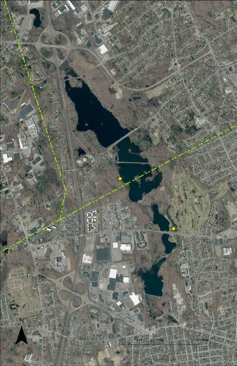
D.W. Field Park is located near the top of the Taunton River watershed, about two miles south of lands draining to Boston Harbor. Water enters Brockton Reservoir via two culverts under Old Pond Street as well as from a culvert across Route 24 to the west and surface flows to the east. It then passes over the spillway into Waldo Lake and, if not used for irrigation or otherwise consumed, continues through the lower ponds before exiting the park as Salisbury Brook. Salisbury Brook merges with Trout Brook in downtown Brockton, becoming the Salisbury Plain River before eventually joining the Taunton River and emptying into Mount Hope Bay of the Atlantic. So, what happens to water in the park has implications for many downstream users
The wetlands around Old Pond Street may contribute greatly to water quality by absorbing and breaking down pollutants from the commercial and industrial district to the north. Local and regional stakeholders may wish to consider adding the two undeveloped parcels northeast of Old Pond Street to the park, if possible, to help maintain this valuable service.

The Brockton Reservoir has been used to supply water for various uses since its creation in 1880; most recently, to provide a portion of Brockton’s drinking water via the Woodlawn treatment plant since 1994. That use was discontinued in 2020 when MassDEP regulations lowered the permissible levels of per- and polyfluoroalkyl substances (PFAS) in drinking water to 20 parts-per-trillion (ppt) (Brockton Water Department, Annual Water Quality Report) (see figure). PFAS are synthetic chemicals that do not break down naturally (earning them the nickname “forever chemicals”) and bioaccumulate in humans and other animals, causing health problems. Because so many different varieties of PFAS exist, Massachusetts requires that utilities test for a representative group of six termed “PFAS6.” Tests of Brockton Reservoir detected PFAS6 at 28 ppt in November 2020 and 24 ppt in January 2021; hence, the reservoir’s use as a water supply was stopped (Brockton Water Department, “Drinking Water PFAS6 Public Education”). Levels above the maximum were also detected in the nearby communities of Avon, Easton, Stoughton, and Abington (MassDEP). Where did the PFAS in the reservoir come from? It is possible that the commercial and industrial district north of the park has been a special contributor; however, the detection of PFAS6 above the 20 ppt threshold at nearby wells implies that widespread use of PFAS-containing products has simply raised the background level of these chemicals to its present amount in southeastern Massachusetts. In 2024, the Environmental Protection Agency published the most cautious PFAS regulations yet, limiting the presence of these chemicals in drinking water to 4 ppt. But even though Brockton Reservoir likely still exceeds the regulatory maximum, this does not mean that its waters should no longer be protected.

Contaminant Levels (MCL) and PFAS Levels Detected in Brockton Reservoir
Historically, Brockton has struggled to find enough drinking water (Markman). Should a natural disaster such as a drought or hurricane compromise the city's existing water supplies, it may be necessary to use the reservoir as an emergency source. Hence, it makes sense to continue protecting the quality of the water in the reservoir. Such protection could include more widespread use of green infrastructure and low-impact development techniques in Avon's commercial and industrial zones north of D.W. Field Park (for example, green roofs on the area's many large buildings). There are also measures that may be taken within the park to improve water quality (see following page).
If and when the overall flux of PFAS into the environment is stopped, biological processes may help to disperse it. There is some evidence to suggest that PFAS compounds are taken up by aquatic plants (Zhang et. al., Zhou et. al.). While the colonization of water bodies in the park by non-native fanwort is currently considered a problem, it may be worth investigating whether these plants accumulate PFAS and, if so, whether they might be "farmed" to help remove it.
PFAS are not the only challenge to water quality in Brockton Reservoir; cars and roads are also sources of pollutants that may negatively impact human health and biodiversity. In addition, roads may function as dams, altering the movement of water across a landscape in conjunction with bridges and culverts. Sometimes these engineered features mitigate human impacts on natural communities and help to manage pollutants and sometimes they do not. Understanding how human infrastructure interacts with topography to define patterns of drainage is the first step toward planning beneficial interventions.
According to Brockton’s Superintendent of Parks, high sodium has been detected in the greens of D.W. Field Golf Course southeast of Waldo Lake. Water for the golf course is drawn from Upper Porter Pond, and park officials wonder whether the sodium is entering Brockton Reservoir from de-icing operations on Route 24 and Harrison Boulevard.
Sodium chloride dissolves in water, and its components move in different ways through the environment. A detailed analysis taking into account topography and chemistry would be needed to determine whether (and where) sodium from road salt is entering the golf course. In general, increasing the area of vegetated land across which runoff travels before it reaches water should increase opportunities for sodium ions to be captured in the soil. There may be opportunities to slow and spread runoff from Route 24 along D.W. Field Parkway West, although those opportunities are not assessed in this document.
While the parkway loop itself is reportedly not treated with salt, it may offer a good opportunity to improve water quality within the park proper. Currently, there are many places where runoff from the road enters the reservoir directly, carrying pieces of asphalt and vehicle pollution. Intercepting this runoff would help to protect the reservoir, as would depaving some of the road surface (see “Road Configurations,” sheet 10).
1. Beaver Brook
Water passes from the wetlands under the cloverleaf into Brockton Reservoir via two culverts under Old Pond Street. This drainage area extends to the top of the watershed, however, the mapped drainage area may differ from the actual drainage area where water passes under D.W. Field Parkway East south of Old Pond Street.
2. Brewster Road
Water from a drainage area that includes the Brewster Road neighborhood in Stoughton is conducted into the reservoir via a culvert under Route 24.
3. Fieldstone Way
Water in the park’s newly acquired thirty acres drains to wetlands impounded by the parkway west of the Beach.
4. Searles Brook
Eastern boundary of drainage to the reservoir.
5. Parkway East
A culvert at the intersection of South Street and D.W. Field Parkway East conveys water from wetlands east of the parkway into the spillway. The extent of this subwatershed is unclear. There is evidence of excavation and fill along a portion of the parkway, the topography suggests a historical outlet at that location, and a hole in the embankment may indicate an unmapped culvert (see pictures). This filled-in stretch of road may be a good candidate for a bridge should funds for ecological restoration become available.


Vehicles and pedestrians share D.W. Field Parkway, a two-lane road about twenty-two feet wide in most places. Gates at its entrances at Old Pond Street, South Street, and Oak Street are opened by park staff every morning and closed at night.
Just north of the Oak Street Parking Area, the parkway becomes a loop that circles Waldo Lake and Brockton Reservoir. While the park gates are closed, pedestrians and cyclists have the road to themselves. After they are opened, the right lane serves one-way vehicle traffic while the left lane remains reserved for pedestrians and cyclists.

South Street and Old Pond Street both cross the parkway and are the only roads in the project area that allow two-way vehicle traffic. South Street is often used as a connector between Avon town center and streets in Brockton that serve large retail outlets and the Good Samaritan Medical Center. Ambulances from the medical center also use South Street to reach Avon (Old Colony Planning Council 3).
Pedestrians have the option of using a sidewalk on the north side of South Street or the elevated walking path along Brockton Reservoir Dam to travel this stretch of road There is no designated path separated from vehicle traffic on Old Pond Street; however, there is also much less traffic.


There are several formal parking areas around Waldo Lake but none around Brockton Reservoir. Many visitors park informally outside the gates (especially before they are opened) at the intersections of South Street and the parkway; also, at the intersection of Harrison Boulevard and Old Pond Street. People also park along the road throughout the loop.
The clients are concerned that parking outside of the gates at the intersections of South Street and the parkway could block emergency vehicles from accessing the parkway.
Many opportunities exist to redesign road surfaces in the park to improve pedestrian safety and the management of stormwater. These range from the simple strategy of ensuring that paved surfaces are tilted away from the reservoir into bioswales or detention basins to the more radical approach of depaving a portion of the road.


Before the construction of Route 24, Pond Street extended west from Avon to connect with Central Street in Stoughton. The highway broke this connection, but today "Old Pond Street" remains connected to what is still called Pond Street in Avon (with crosswalks newly installed across Harrison Boulevard). It is also the northernmost segment of the parkway loop and (with the exception of the noise from Route 24) the quietest.
As a feature of the landscape, the earth beneath Old Pond Street functions as a dam, slowing water from upstream before it enters Brockton Reservoir. This slowing allows heavy particles to settle out, potentially protecting the reservoir from some pollutants. Shallow water along the edges of the land also creates a wetland environment where biological processes break down some pollutants and contribute to the park's biodiversity.
The road shoulders between the park gate and Harrison Boulevard are used as an informal parking area and can accommodate at least eight vehicles. After
the gates open, cars sometimes also park along the street east of the triangle and in a cleared area in the northwest corner. This cleared area is used as a turn-around point, allowing drivers to treat the street as two-way even though it is officially one-way west of the triangle.
There are two privately owned lots north of Old Pond Street beyond the gate, and the clients are interested in moving the gate west so as not to limit access to these lots. Should this happen, cars that drive into the park when the gate is closed will need a place to turn around. The clients are also interested in closing the informal parking area in the northwest corner so that the parkway loop is consistently one-way. They have suggested using this northwest corner, where surface flow from an unidentified source (perhaps a spring or unmapped culvert) flows into the water north of Old Pond Street, as a stormwater management area.


This design ensures the consistency of one-way traffic on the parkway and solves the potential problem of restricted access to the lots north of the street and by moving the gate past the western point of the triangle and transforming the triangle into a roundabout. The left lane of the parkway remains reserved for pedestrians as it passes the roundabout.
This design does not add new parking but instead formalizes the informal parking areas that currently exist (should Old Pond Street be repaved, it could also be regraded so that grade reversals direct runoff south from roadside parking; this would also discourage speeding). This design also attempts to mitigate the pooling of water east of the triangle/roundabout by installing a culvert under D.W. Field Parkway East where water currently trickles under the road (further investigation is necessary to determine whether this would be effective). This design concept establishes a woodland trail south of Old Pond Street that visitors may use to enter the park. Meadow grasses and native wildflowers are established at the former parking area in the northwest corner and above the gas line right-of-way (see "Road Configurations," sheet 10).
Should construction of the roundabout require removing some or all of the Norway Spruces in the triangle, this design replaces those trees with hybrid American Chestnuts bred to withstand the chestnut blight. D.W. Field Park was once prime chestnut habitat as evidenced by the many surviving trees throughout the park, and efforts to re-establish this once widespread tree could symbolize high aspirations for the future of the park and those who use it.
• Minimizes disturbance to one area.
• Enforces one-way traffic on the parkway loop.
• Eases access to the lots north of Old Pond Street.
• Gives visitors multiple ways to approach the park.
• May mitigate drainage issues east of the roundabout/ triangle.
• Some drivers may exit the roundabout the wrong way onto D.W. Field Parkway East (this could be avoided by including a triangular island and clearly demarcating the pedestrian lane).
• Establishing and maintaining meadows requires technical expertise.
• No additional parking.

Instead of fighting visitors’ tendencies to park at the juncture of Old Pond Street and D.W. Field Parkway West, this design concept accepts that impulse and encourages it, establishing a formal parking area in the northwest corner of the park and permitting two-way vehicle traffic along the length of Old Pond Street. Here, this transformation of the northwest corner into a “hub” is illustrated assuming the scenario of closing the parkway to vehicle traffic and narrowing the roadway.
This design formalizes the existing informal trails in this area of the park and renovates the causeways that have fallen into disrepair around Rock Island so that visitors who park in the new lot have many walking paths to choose from. It adds a new causeway, extending north from the parking area, that both serves as part of the trail network and creates a retention basin.
One factor that could make this design impossible is the width of Old Pond Street where it crosses the reservoir. It is not clear that the street can be made wide enough along this stretch to accommodate both two-way vehicle traffic and a pedestrian lane, and some park visitors may not want to use the causeways to cross the reservoir.
• Aside from growing herbaceous plants, this may be the best use of the area over the gas line and under power lines. Assuming that parking over the gas line is allowed, a parking area in this location could accomodate many vehicles.
• Renovated causeways offer many of ways to traverse the northern section of the park.
• The eastern leg of the triangle may be removed in this scenario, restoring some wildlife habitat and creating a pedestrian-only throughway.
• Old Pond Street may not be wide enough for a pedestrian lane alongside two-way vehicle traffic.
• Electric lighting must be carefully sited to minimize negative effects on wildlife.
• The potential effectiveness of a retention basin in this location requires further investigation.
The final design for Old Pond Street focuses on the Triangle area. It fulfills the design criteria of enforcing one-way traffic on Old Pond Street west of the Triangle by repaving this section of the road, raising the left/southern lane two inches above the right/northern lane and clearly marking the left lane with paint. It also moves the park gate to the northern corner of the triangle, allowing visitors to use the existing informal parking spaces along Old Pond Street before the gates open.
This design also improves pedestrian and driver safety, restores wildlife habitat, and addresses the problem of deteriorating infrastructure with an integrated set of road, path, and drainage improvements. It splits pedestrian and car traffic where the parkway meets Old Pond Street by reducing the eastern leg of the triangle to a single lane for cars and turning the southern leg into a pedestrian-only path. The eastern leg is also rerouted to meet Old Pond Street at a ninety-degree angle so that drivers are not tempted to cruise past the stop sign. A portion of the former road is preserved to serve as a turn-around space in front of the gate and an arrival area for walkers along the trail proposed in Alternative 1.
The new road segment is protected from erosion by grading and drainage features around the road and path. A culvert under the road conveys pooling water into the triangle where it may then exit under a wooden footbridge. Space under the bridge allows amphibians to access upland habitat.


Existing Norway Spruces

The proposed grading pattern is inspired by the idea that this stretch of parkway, like others throughout D.W. Field Park, may have been filled in to create the parkway loop, closing off a pre-existing hydrologic connection between the lowlands and surrounding uplands. This connection may have extended all the way to the wetlands north of Pond Street (see previous page). It is hoped that restoring this connection in this way will not only protect the park's infrastructure but also increase the available habitat for amphibians and other creatures who move between open water and terrestrial habitats.
Most excavation for the proposed drainage feature is confined to area that is currently paved (although some is required east of the new road location). Grading for the compacted dirt paths is not shown. The proposed pedestrian footbridge is at elevation 219 on its western abutment and 220 on its eastern abutment with a minimum elevation below the bridge of <217.

The proposed design leaves the Norway Spruces on the north side of the triangle as they are. It replants the work area around the pedestrian path with a combination of understory plants, small trees, and large trees.
Understory plants could include Serviceberry/Shadbush (Amelanchier canadensis), Chokeberry (Aronia spp.), Sweet Pepperbush (Clethra alnifolia), Virginia Sweetspire (Itea virginica), and Spicebush (Lindera benzoin).
Small trees could include Witch Hazel (Hamamelis virginiana) and native Dogwoods (Cornus spp.).
Many options exist for large trees that will grow with the park and its community, replacing the shade from the lost Norway Spruces in time. These include Red Maple (Acer rubrum), Sweetgum (Liquidambar styraciflua), Swamp White Oak (Quercus bicolor), and Pin Oak (Quercus palustris) among others. This site may be a good location to plant hybrid varieties of the American Chestnut (Castanea dentata) that have been bred to withstand the Chestnut blight. Attempts to create blight-resistant strains of this once widespread and ecologically important forest species are ongoing; the park's participation in these experiments would be a way to celebrate the past while looking toward the future.
Above busy South Street, nestled between a line of old poplars and Brockton Reservoir, sits a gravel walking path that runs the entire length of the Brockton Reservoir Dam, about 1,800 feet in length.


path connects to an


Another set of stairs at the eastern end connects the elevated path to the sidewalk along South Street. The elevated path joins the D.W. Field Parkway on the western end.


and other shrubs cover the steep embankment of the dam before leveling out to a wide turf lawn bordering South Street, all of which is mown regularly.

The steepness of the embankment and the sometimes thick vegetation puts the elevated walking path and the reservoir out of sight from vehicles and pedestrians on South Street.

The roots of the old poplars stick out three to four inches above the gravel surface in some places and sprawl across the path as they extend toward the stone wall of the dam, creating tripping hazards. Because of the encroaching roots and vegetation, the once six-foot wide path has shrunk significantly and become inconsistent in size throughout.

A sidewalk runs along the north side of South Street, but promptly ends and turns into a two-foot wide foot path as it passes by the spillway and over to the intersection of South Street and D.W. Field Parkway east.

The spillway, home to one of the park’s waterfalls, carries water from Brockton Reservoir into Waldo Lake.


The Massachusetts Office of Dam Safety has determined the Brockton Reservoir Dam to be of “significant hazard”, referring to the extent that surrounding communities would be affected if it were to fail. The National Inventory of Dams has rated the condition of the dam to be “fair.” Though neither of these designations are especially good nor bad for their respective categories, the two designations together raise questions about the safety of the dam moving forward. The mature poplars along the walking path provide shade and ecological functions, but their presence may be cause for concern. Tree roots on earthen dams can loosen embankment soil and cause seepage paths, leading to erosion, hydraulic issues, and even dam failure. High winds, old age, and disease can also cause trees to fall and expose the root system, damaging the integrity of the dam.

Accessibility and views are enhanced in this design. A bridge over the spillway provides an up close view of the waterfall while serving as a connection between the elevated walking path and the South Street and D.W. Parkway intersection. Decks along the path offer spaces to relax, picnic, or take in the views of Brockton Reservoir.
• A six-foot-wide crushed gravel path allows people to pass one another easily, including those using wheelchairs.
• A bridge over the spillway increases accessibility to the path from the intersection of South Street and D.W. Field Parkway.
• The areas under the pergolas provide seating and picnicking options.
• The meadow replaces turf and improves pollinator habitat.
• The trees stay in place, providing habitat and necessary shade along the path.
• The potential threat that the trees have on the integrity of the dam is not addressed.


Meandering paths meet at the base of the pump house staircase, providing an alternative street crossing to the busy intersection. Pergolas provide shade and define seating areas overlooking the reservoir and the meadow.
• A 5% path from the sidewalk to the top of the dam is accessible for all persons.
• A speed table and planting strip create a safer pedestrian experience on the sidewalk and while crossing South Street.
• The location of the speed table and access path entrance encourages a connection to trails south of South Street.
• Crossing at the speed table may be safer for pedestrians than crossing at the intersection of South Street and D.W. Field Parkway.
• Removing trees along the walking path may extend the life of the dam.
Cons
• Removing trees along the walking path eliminates shade and may be costly given their location.
• Using the sidewalk to get to the 5% access path may feel unsafe to some users because of the speed of the traffic.

Trail expansion offers accessible opportunities for relaxation and recreation along the shores of Brockton Reservoir and Waldo Lake. Increased native vegetation, viewing decks over the water, and informational signs help create an inviting and educational experience for walking path users. The crushed gravel path is widened to six feet. Options for establishing an even walking surface over tree roots are shown in “Design Details” (sheet 18).
A six-foot-wide bridge spans the spillway, allowing access to the elevated walking path from the northwestern corner of the South Street and D.W. Field Parkway intersection and offering up close views of the waterfall. People using wheelchairs can now access the elevated path from the intersection.
A wooden viewing platform encompasses the pump house, bringing users out over the water.
A 15 by 30-foot wooden deck extends over the water and offers seating and tables for picnicking or relaxing.
Interpretive signs line the path, informing users of the history of the park and the habitat value of the meadow.
A meadow replaces the saplings and shrubs along the embankment as well as the mown turf near the sidewalk, bringing color to the hillside and encouraging pollinators.
South Street shrinks from its original 23.5 feet width to 21 feet, allowing room for a planting strip between the sidewalk and the busy road. This also allows for the sidewalk to be extended over the spillway. Both of these improvements support pedestrian safety and comfort.
A speed table with flashing pedestrian signs intersects South Street at the foot of the historical pump house staircase, creating a safer crossing for pedestrians.
Revitalized trails bring users to the shore of Waldo Lake or to an existing walking trail to the east. This trail connection allows users to cross South Street at the speed table instead of at the busy intersection of South Street and D.W. Field Parkway.
A bridge leads pedestrians across a small section of water where the spillway empties into Waldo Lake.

Additional signage and amenities in this design include “Speed Limit” signs at each intersection of South Street and D.W. Field Parkway, encouraging drivers to slow down while in the park, and signs along the path and decks enforcing the park’s rules against swimming or fishing in Brockton Reservoir. In an effort to keep waters clean, signage also discourages users from feeding the waterfowl and explains the detriment it has to the animals’ and water body’s health. To accommodate for the increase in picnic areas, additional trash and recycling receptacles and portable restrooms are placed north of the intersection of South Street and D.W. Field Parkway east.


Tree roots stick out three to four inches above ground in some places along the existing gravel path, making the trail inaccessible to wheelchair users. In addition to extending the width of the path, one of the following alternatives should be used to create a smoother, more accessible surface.

Crushed gravel is used as fill on top of the existing tree roots to create an even walking surface that is consistent in material with the rest of the path.
Increased fill and compaction on tree roots may be detrimental to the health of the trees over time, which in turn could impact the structural integrity of the earthen dam.

Small sections of wooden boardwalk with accessible on and off ramps are built up over extruding roots, giving the roots room to grow and minimizing compaction.
Sections of the walking path are nearly level with the top of the stone wall of the dam. Raised boardwalks in those sections would be higher than the dam wall, and may require a guardrail.

On the southern side of the line of trees, a path is built on top of gravel fill with large stones keep it in place. This allows the walking path to swerve around trees to avoid extruding roots where necessary.
Sourcing and moving large stones and gravel fill will be expensive and more labor intensive than the other alternatives.

Parkway traffic meets a busy cross street at the unsignalized intersection of South Street and D.W. Field Parkway East. Here, pedestrians may stroll between the elevated walking path atop the dam and the parkway. However, the current layout of this site poses challenges to both vehicles and pedestrians.
Drivers who wish to get out and walk around the reservoir in the morning, before the park gates are opened, must either park at the Oak Street Lot and walk a considerable distance or park along the curb outside of the gates, a practice not approved by park staff. The clients have requested designs that include parking for four to six vehicles at this intersection to accommodate the roughly four vehicles that park outside the gates on busy mornings.
Pedestrian traffic from the west is limited by a sidewalk that ends at the dam spillway, forcing walkers coming from South Street to cut into the road (see image A). Walkers heading north on the parkway must contend with a crosswalk that does not meet the opposite curb and a lane that is often blocked by parked cars. Stones embedded in the ground to discourage parking, and the park gates themselves, block many possible pedestrian routes. There are two compacted dirt paths on the northwest corner of the intersection, but the Conway team observed that most walkers stay on the road even if it means walking around parked cars.
Landscaping around the intersection includes mown grass and several non-native species including Norway Spruces and Euonymus. Water from wetlands north of the site is gathered into a short stream that enters a culvert and empties into the spillway.


Parking area with three standard 9' x 20' spaces and one accessible 10' x 20' space with a 5' wide access lane.
Large tree at corner to shade impervious surfaces (road, parking area).
Sidewalk from parking area crosses road at right angle.
Bridge over spillway.
Sidewalk widened to accomodate walkers and wheelchairs.
Corners moved inward to slow traffic and ease pedestrian crossings.

Speed table slows traffic and signals pedestrian zone.
Native understory plantings including witch hazel, rhodedendron, and ferns replace non-native Euonymus to extend forest ecosystem.

A small off-street parking area (four spaces) for early-morning joggers and walkers is sited to the northeast of the intersection and accessed via the parkway. Cars are slowed at the intersection by drawing in the corners of the intersection and adding a raised and textured speed table.
• Narrower intersection and speed table slow traffic, clearly establishing a pedestrian-friendly area.
• Off-street parking does not block pedestrians or emergency vehicle access.
• Widened sidewalk and bridge across spillway connect South Street and the parkway.
• Provides opportunity to replace ornamental plants with native species.
• Requires felling three large pine trees.
• Construction of parking area in wetland buffer may require permitting.
This design explores creating an access "hub" northwest of the spillway assuming the scenario of restricted vehicle access to the parkway. The stretch of road between South Street and the parking area becomes two-way, and the road beyond the parking area becomes an 11' wide path for cyclists and pedestrians. While this design may have a higher impact on the local area than Alternative 1, requiring some destruction of the forest northwest of the spillway, it accompanies a reduction in the overall amount of impervious surface around the reservoir.
Because the parkway north of the South Street intersection becomes two-way (meaning that pedestrians can no longer walk in the left lane of the road), it becomes critical that pedestrians have a clear connection from the southwest corner of the intersection to the northwest corner. Moving the corners of intersection inward (as in Alternative 1) allows the gates south of the intersection to be moved closer to the road; combined with moving the stone blocks north of the monument and leveling the ground, this allows pedestrians to walk between the monument and gate, supplementing the narrow path to the left of the monument that may not be accessible to some people (see dashed line).
Beyond the new parking area, the path splits so that walkers have the option of staying near the road or walking along the water
• Parking on street already works for some purposes. Pros
• Scaleable, pattern may be extended along parkway to create more parking spaces.
• Creates spaces for site amenities (picnic tables, restrooms). Cons
• Relatively high impact; may degrade wildlife habitat and water quality if not balanced by ecosystem restoration elsewhere.
• Two-way traffic on parkway may cause headaches.
This design builds on the Pocket Parking concept by shifting the end of the paved walkway from the bridge to the corner of the intersection. By narrowing the intersection and adding a speed table and high-visibility signs, it clearly signals to drivers that they are entering a pedestrian-friendly zone.

Thirty acres of wetlands and forest just west of Waldo Lake were purchased by the Town of Avon in March of 2024 and added to the park with the help of a Municipal Vulnerability Preparedness Program grant. Much of this site was slated for development at one point, and remnants of a cleared and graded road cutting through the parcel are still noticeable today. Young, thick pine forests have replaced the once cleared road, while an old oak canopy shows the forest’s years in less used areas. Large boulders sit along the wetland edges in some places, and thick patches of fern cover the ground in others. This portion of the park is currently accessible from “The Beach” parking lot to the east, though footpaths show evidence of neighbors walking in from the north and west as well. Vehicle and foot traffic moves east-west along South Street and north-south in and out of surrounding neighborhoods and along D.W. Field Parkway. Fieldstone Way, with only one residential home on it, meets the 30-acre parcel in the north, while Katherine’s Way connects to the western portion of the parcel where wetlands are more dense. Overall, water drains east across the parcel, making its way downhill and into surrounding wetlands before connecting to Waldo Lake via a culvert under “The Beach” parking lot

• A great view of Waldo Lake is presented from on top of a knoll in the southeastern corner of the parcel.
• Large boulders edge the wetlands and an open canopy with minimal shrubbery in the understory may act as a gathering space or point of interest (star icon on map).
• D.W. Field Parkway is visible and audible from about 300 feet into the parcel, which may provide a sense of security or a lack of privacy depending on the user. Multiple community members expressed their uncertainty in wanting to use forested paths due to feeling unsafe. They concluded that they may be more inclined to use said paths if they were near the road or near larger groups of people.

• Steep slopes (10% or greater) and wetlands cover much of the eastern portion of the parcel, creating accessibility and erosion challenges for connecting trails to/from “The Beach” parking lot.
• Nearby neighborhood residences are within view and earshot along the western edge of the parcel, decreasing privacy.
• Activities are regulated within a 100 foot buffer zone of wetlands. The only portion of the parcel outside of a wetland buffer zone is in the northwest corner, potentially limiting trail design.
• Thick understory shrubs and young pine forests create dense thickets of land that are difficult to pass through. On the other hand, some areas of the forest are completely clear of all vegetation.


Protecting this patchwork of forests and wetlands will help preserve wildlife habitat and ecological function in an otherwise built up environment. The clients would like to see minimal impact on these functions while also creating access into this newly acquired piece of land. Providing trails and trailhead parking creates opportunities for people to take long walks in the woods unlike anywhere else in the park, and the wetlands and successional forest may provide educational opportunities as well. The clients hope to provide another point of entry with four to six trailhead parking spaces off of Fieldstone Way to the north, and wish to see any proposed trails maintaining the connection to "The Beach" parking lot as well. In an effort to protect intact wetlands, trails and/or trailhead parking is not considered for the southwestern portion of this parcel bordering Katherine's Way in either alternative.

A half-mile loop trail brings users through different forest types, weaves through historic stone walls, and offers a secluded feel despite its proximity to the park and surrounding neighborhoods. Just a short walk from “The Beach” parking lot, a picnicking area provides a view of Waldo Lake, while users looking for a longer hike can begin at the Fieldstone Way trailhead or opt for the full loop.
• The length of trail allows users to experience a longer hike through different elevations and ecosystems than "A Wetland Wonder."
• The picnic area/Waldo Lake overlook is close to "The Beach" parking, and trails connect to "The Beach" parking lot.
• The design has minimal impact on wetlands.
• The trail crosses through sections of steep terrain and is not accessible for all persons.
• The sections of the loop that are far away from D.W. Field Parkway may feel unsafe for some users.


An accessible quarter-mile long boardwalk loop allows users to experience the park’s wetland ecosystems up close without venturing too far into the woods. On the observation deck, informational signs and benches provide a spot to rest, to learn, and to enjoy the view from higher ground.
• The boardwalk loop is accessible for all persons.
• Interaction with wetlands allows for educational opportunities.
• The proximity of the boardwalk loop to D.W. Field Parkway may help users feel more safe.
• The viewing platform may be used as an interpretive site and secondary picnic area.
• The picnic area/Waldo Lake overlook is close to "The Beach" parking lot.
• The design includes heavier impact on wetlands, and more permitting is likely required.
• The proximity to D.W. Field Parkway may feel less private or peaceful to some users.
• There is no option for a longer hike in the woods.
In this design, a quarter-mile long accessible boardwalk loop from The Beach parking lot brings users across wetlands and out to an overview deck. Those looking for a longer hike can continue on the half-mile walking trail to trailhead parking off of Fieldstone Way, or complete the entire loop. Spur trails in the southeast lead to private picnicking areas with beautiful views of Waldo Lake.

Key Features
Trailhead parking offers spaces for six vehicles and a kiosk with trail information.
The walking trail passes through gaps in historic stone walls.
The picnicking area offers overlook of Waldo Lake close by The Beach parking lot
The Beach parking lot serves as a second entrance to the trail system and Waldo Lake overlook.
The six-foot-wide boardwalk passes through wetlands and is accessible for all persons
The viewing deck offers benches and informational signs about wetland ecosystems, serving as a secondary picnicking area and interpretive site.

This design assumes the redesign of The Beach parking lot as shown in the 2023 Conway report, Resilience and Recreation (Ervin and Logan). Additional elements necessary to integrate the two designs include a speed table across D.W. Field Parkway and a small boardwalk over the proposed vegetated swale. Both of these design elements help provide a safe and accessible entry point to the trails. From this entry point, the trail maintains a six-foot width for the entirety of the boardwalk loop and up to the Waldo Lake Overlook. Beyond the overlook, the trail width decreases to four feet for the rest of the walking loop.


Five parking spaces and one accessible parking space with room for an access aisle are available off of Fieldstone Way in the northern part of the property. Vehicles pass by a single residence on the quiet road before reaching the parking area and trailhead. A trail to the east of the parked cars brings users through a gap in the stone wall to a kiosk with trail information. From there, the trail leads through another section of stone wall before coming to a “T” where users can choose which direction they would like to hike the loop in. A spur off of the boardwalk loop leads to a peaceful resting spot among the wetlands and forest.

The Conway Team would like to thank Rachel Bruce of Wildlands Trust, Tim Carpenter of the City of Brockton, Rhiannon Dugan of Old Colony Planning Council, Wayne Feiden of UMass Amherst, and Richard Jordan of the Town of Avon for their support and cooperation. This project was made possible by a MVP Grant to the Town of Avon.
Brockton Water Department. “Drinking Water PFAS6 Public Education.” PWS ID#: 4044000, March 2021.
Brockton Water Department. Annual Water Quality Report: Reporting Year 2022
CAPA Strategies. Brockton MA Heat Watch Report. October, 2023.
Dalton, Evan N., and Molly W. Jacobs. “D.W. Field Park Habitat Assessment and Natural Resource Inventory.” Manomet Conservation Sciences. 31 March, 2023.
Davison, Warren. Draft Sketch (ArcGIS Pro style pack).
EPA. “Reduce Urban Heat Island Effect.” United States Environmental Protection Agency. 17 April. 2024. https://www.epa.gov/green-infrastructure/reduce-urban-heat-island-effect
Ervin, B and Audrey Logan. Resilience and Recreation: Conceptual Designs for D.W. Field Park. June 2023.
Kennen, Kate, and Niall Kirkwood. Phyto: Principles and Resources for Site Remediation and Landscape Design. Routledge, 2015.
Manomet. D.W. Field Park Habitat Assessment and Natural Resource Inventory. 31 Mar. 2023.
Markman, Joseph. “A History Lesson on Brockton’s Water Woes.” The Enterprise. 8 Sept. 2014. https://www.enterprisenews.com/story/news/2014/09/08/a-history-lesson-on-brockton/36512674007.
Massachusetts Cultural Resources Inventory (MACRIS). “Historic Area Detail: D.W. Field Park.” https://mhc-macris.net/details?mhcid=BRO.A
MassDEP. “MassDEP addressing PFAS contamination” (story map). https://www.mass.gov/info-details/per-and-polyfluoroalkyl-substances-pfas
Old Colony Planning Council. “Road Safety Audit: South Street Corridor between Parkview Lane and Leo’s Lane.” 30 March 2023.
Zhang, Dong Qing et al. “Distribution of perfluoroalkyl substances (PFASs) in aquatic plant-based systems: From soil adsorption and plant uptake to effects on microbial community.” Environmental Pollution vol. 257 (2020): 113575. doi:10.1016/j.envpol.2019.113575
Zhou, Yunqiao et al. “Ecological effect and risk towards aquatic plants induced by perfluoroalkyl substances: Bridging natural to culturing flora.” Chemosphere vol. 167 (2017): 98-106. doi:10.1016/j.chemosphere.2016.09.146
Zygmunt, Joanne and Alyssa Papantonakis. Summary of Findings: Community Park Needs Survey. 16 Sept. 2023.