Resilience Between Rivers
Updates to the “Land Use” and “Natural, Historic, and Cultural Resources” Chapters of Sustainable Greenfield, Greenfield’s 2014 Master Plan


Prepared for the City of Greenfield
Aaron Dell, Jessica Ladin, and Annie Mellick
The Conway School Winter 2024
Resilience Between Rivers
Updates to the “Land Use” and “Natural, Historic, and Cultural Resources” Chapters of Sustainable Greenfield, Greenfield’s 2014 Master Plan
Prepared for the City of Greenfield
The Conway School, 2024
Aaron Dell, Jessica Ladin, Annie Mellick
Acknowledgments
The Conway Team would like to acknowledge the extensive and valuable assistance provided by our partners from the Sustainable Greenfield Implementation Committee (SGIC):
Mary Chicoine, SGIC Chair
Nancy Hazard, SGIC Public Member
Jonah Keane, SGIC Public Member
Eric Twarog, City of Greenfield Planning & Development Department Director
We would also like to thank everyone who took the time to speak with us about the issues facing Greenfield and what makes it a great place to live.

Contents Executive Summary������������������������������������������� 5 Introduction ������������������������������������������������������ 7 Land Use Introduction ����������������������������������������������������13 Climate Change �����������������������������������������������20 Downtown �������������������������������������������������������22 Housing 24 Water and Infrastructure ��������������������������������27 Solar Energy 32 Conclusion �������������������������������������������������������33 Natural, Historic, and Cultural Resources Introduction ����������������������������������������������������35 Geology, Aquifers, and Soils 36 Forested Greenfield ���������������������������������������38 Water Resources ���������������������������������������������44 Connectivity Planning & Conservation 53 Threats to Wildlife�������������������������������������������59 Recreation 60 Agriculture �����������������������������������������������������64 Historic Resources ������������������������������������������67 Cultural Resources ������������������������������������������73 Conclusion �������������������������������������������������������79 Recommendations 80 Map Data���������������������������������������������������������87 Works Cited 88
Executive Summary
This update to the “Land Use” and “Natural, Historic, and Cultural Resources” chapters of Greenfield’s 2014 Master Plan, Sustainable Greenfield, is the outcome of a partnership between the Conway School and the City of Greenfield. A team of three students from the Conway School reviewed the progress made by the Sustainable Greenfield Implementation Committee (SGIC) in implementing the Master Plan since 2014 as well as more recent planning documents to understand the city’s goals and its progress toward achieving them. The Conway team also conducted two community engagement sessions, the first to refine the scope of the project and the second to gather feedback about specific recommendations. This final report incorporates the information gathered from the community engagement events, spatial analyses, additional research, and input from individual citizens and experts to make recommendations about how Greenfield can improve its residents’ quality of life while conserving its historical and cultural heritage and restoring and protecting its natural environment.
Sustainable Greenfield established the complementary land use goals of encouraging infill development and conserving open space, and this update carries those goals forward. By focusing development in already-built areas, the city can minimize the costs associated with new development; while, by protecting open spaces, it can ensure the continued existence of finite resources such as forests and farmland. Since 2014, the price of housing has risen dramatically, and so the need to densify downtown has grown acute. This update recommends zoning reforms that would make it easier to build more housing downtown such as allowing multifamily dwellings by right in more areas, raising the maximum allowable number of units in new multifamily dwellings, and updating dimensional standards to allow row houses. It also stresses that affordability and accessibility to people of all ages and abilities must be a priority in efforts to expand the city’s housing stock.
The goal of infill development can also be understood as part of a broader ongoing effort to revitalize the downtown area. Measures that encourage the renovation and creative reuse of urban spaces (including underutilized parking lots) remain needed as Greenfield, like many other cities and towns across the United States, struggles to understand what a Main Street can or should look like after the proliferation of online retail. Part of the answer, as suggested by community engagement participants, may include expanding and caring for community spaces and green spaces, perhaps with the coordinated aid of volunteers. It may also include maintaining and strengthening the city’s focus on inclusion of non-vehicular traffic.
Climate change has and will continue to intensify some of the problems facing Greenfield while also posing new challenges. The city’s already-pressing need for housing will only grow should there be in-migration from coastal areas due to storms and sea-level rise; but, as more housing is constructed, infrastructure must also be able to support a greater population. Currently, Greenfield’s sewer and storm-water systems are aging and over-capacity, frequently stressed by heavy rains. The city is seeking, and should continue to seek, opportunities to overhaul these systems, and it should do so in ways that promote the well-being of the broader natural environment whenever possible. The same goes for its efforts to grow solar; participants at the second community engagement meeting were nearly unanimous in asserting that the city should prioritize new solar on rooftops or already-disturbed areas, not forests or farmland.
Greenfield’s waterways, wetlands, and forests are remnants of a once continuous natural landscape that has only relatively recently been fragmented by human uses. At the community engagement events facilitated by the Conway team, many participants voiced their desire to conserve and restore remaining natural landscapes, which not only provide recreation opportunities and ecosystem services such as floodwater storage and carbon sequestration but also contribute to the city’s unique character. This report identifies continuous “habitat corridors” where Greenfield should focus its conservation efforts, notably along waterways and north-south ridgelines. It proposes adopting a River Corridor Zone along the Green River that would recognize erosion hazards and respect the river’s natural meander, and it also discusses the strategy of creating “patches” in the urban landscape with street trees, pollinator habitat, rain gardens, and other features that may function as “stepping stones” for birds, pollinators, and other wildlife.
The report also recommends that, along with protecting priority natural landscapes, Greenfield continues its efforts to conserve agricultural lands. Soils suitable for agriculture may be permanently displaced or degraded by development, and so it is important to the region’s food security that farmlands on prime agricultural soils remain in agricultural use whenever possible (this is especially critical given the possibility of disruption to food systems due to climate change). Greenfield’s agricultural lands also contribute to its identity as a “food hub,” and this report recommends that the city further develop its food production, processing, and distribution ecosystem by seeking additional complementary industries (space for which remains available in the city’s industrial park).
Greenfield LU/NHC Update 5
Greenfield’s natural and working landscapes are keys to its identity as a community; so are its recorded history, the physical traces of that history, and its ongoing cultural traditions. Many participants in the community engagement events facilitated by the Conway team expressed a strong desire for a sense of local history and identity that includes but not limited to the era following European colonization, and this report recommends that the city continue and deepen its efforts to recognize the long tenure and continued existence of Indigenous people here wherever possible. The plan emphasizes the intrinsic value of Greenfield’s natural beauty, historical sites, and cultural richness, recognizing them as vital elements of the city’s identity and community well-being. It also poses questions about how the city might develop a positive vision for its future while holding on to what is most important in its past.
By integrating sustainable development practices, environmental care, and efforts to protect heritage, Greenfield aims to create a future where its assets can continue to flourish for generations. The plan’s recommendations provide a roadmap to guide the city toward this shared vision of sustainability and resilience.
Greenfield LU/NHC Update 6
Introduction
Deep Roots, Turbulent Forecast
This update of the “Land Use” (LU) and “Natural, Historic, and Cultural Resources” (NHC) chapters of Sustainable Greenfield, Greenfield’s 2014 master plan, is the outcome of a partnership between the City of Greenfield and the Conway School.
Our goal was to identify strategies to build resilience in the face of climate change and the loss of biodiversity while enhancing the quality of life of the people who live in Greenfield. In order to achieve this, three graduate students from the Conway School reviewed the progress made in implementing Sustainable Greenfield since 2014. They also reviewed more recent planning documents, including the 2021 Open Space and Recreation Plan and the 2023 Downtown Revitalization Plan and, in coordination with a four-person team representing the Sustainable Greenfield Implementation Committee, engaged the community in two meetings to learn about what people in Greenfield value and their hopes for the future.
This document reflects those efforts as well as the latest predictions about how climate change may affect Greenfield and Franklin County. It offers analyses of issues facing the city that fall under the general topics of Land Use and Natural, Historic, and Cultural Resources (two of the seven required chapters of a comprehensive plan under M.G.L. Ch. 41 § 81D), and it recommends measures the city can take to address those issues through mechanisms such as zoning, policy, coordination with other organizations, communication and outreach, further planning efforts and boots-on-the-ground projects. Where appropriate, it acknowledges issues that relate to Land Use and Natural, Historic, and Cultural resources but that may be addressed in more detail in other chapters of the comprehensive plan.
Greenfield is a city of approximately 17,470 residents situated at the confluence of the Fall, Green, Deerfield, and Connecticut Rivers. It is also the meeting point of Route 2 and Interstate 91 and is often described as the “hub” of Franklin County, Massachusetts. The territory in and around Greenfield is the traditional homeland of Native peoples including the Pocumtuck. After its settlement by European colonists, Greenfield’s economy centered around agriculture and then transitioned into manufacturing, which grew thanks to river access and hydro-power. This growth lasted until the second half of the twentieth century when it was curtailed by economic globalization; however, synergy between the town’s agricultural and industrial elements has since helped to make Greenfield a center of food processing and distribution as well as precision manufacturing. Today, Greenfield remains a dynamic community with artistic and cultural resources concentrated in its southeastern urban core as well as an abundance of open space and farmland to the north and west.

Greenfield LU/NHC Update 7
Regional Context
Franklin County is the northernmost of three Massachusetts counties along the Connecticut River (the other two being Hampshire and Hampden). Massachusetts county government was disbanded in 1997 (Massachusetts Acts of 1996, Ch. 151, §567), but coordination and planning among local governments continues under the Franklin Regional Council of Governments (FRCOG). Greenfield, formerly the county seat, is the most populous city or town within Franklin County, and its location at the intersection of major roads, rivers, and rail lines makes its description as a regional “hub” appropriate. The contrast between uplands and river valley is the most salient geographical feature of Franklin County as a whole, with Greenfield and its neighboring towns of Gill, Montague, and Deerfield occupying a low plain along the river as it descends from Northfield.
Green River
VERMONT
D e e r f i e l d R i v e r C o n n e c t i c u t R i v e r
NEW HAMPSHIRE MASSACHUSETTS
Community Engagement
So that these updated chapters of Greenfield’s comprehensive plan might reflect the perspectives and aspirations of those living in Greenfield, the Conway team facilitated two community engagement events: an in-person meeting on February 5, 2024 at the John Zon Community Center (followed by an online questionnaire for those who could not attend) and a follow-up meeting on Zoom on March 11, 2024. Participants included former and current city council members, former mayors, planning board members, teachers, climate activists, housing advocates and more.
About eighty people attended the first community engagement event, and forty-nine people completed the accompanying online survey. The first event was designed to elicit a broad spectrum of responses about Greenfield’s challenges and assets. It was organized around four focus areas: “Our Greenfield” (land use and development), “Wild Greenfield” (natural resources and biodiversity), “Food Hub” (the food web within Greenfield), and “Cultural Heritage” (Greenfield’s identity and history). The Conway team constructed stations for each focus area with questions and activities at each station that allowed community members to engage in conversation and voice their opinions.
Responses from this first meeting showed clear trends. On the topic of development, housing emerged as a primary theme. Both attendees of the meeting and respondents to the accompanying online survey emphasized a need for affordable housing and expressed concern about the recent rise in real-estate prices. Among sixty-eight responses to the question of what issue facing Greenfield was most important, twenty-one mentioned housing. One person wrote,
I’ve lived here my entire life and investors from out of town buy every house I can afford. I’m close to having to move out of the city I grew up in due to this.
When asked to choose three “development priorities,” a clear majority chose housing:
Another common theme was the city’s urban core. Many participants noted the diminishing presence of local retail in the downtown area and the presence of large stores west of downtown. Along with calling for a revitalized central district, respondents expressed an interest in enhancing the city’s infrastructure to include more pedestrian-friendly transportation options such as bike lanes and safer sidewalks as well as improvements in public transportation to ensure connectivity across different parts of the city and to landmarks like Poet’s Seat and the Green River. Part

Greenfield LU/NHC Update 9
Housing 86 Renewable energy 47 Culture 45 Retail 40 Industry 26 Outdoor recreation areas 26 Agriculture 23
of a community-created timeline of Greenfield’s history from February 5 event.
When it came to conservation, water emerged as the leading interest. In another pick-three exercise, seventy-nine respondents chose water (wetlands, rivers, and streams) as a “conservation priority” followed by street trees and pollinator habitat with fifty-three votes each. This pattern of response seemed to reflect residents’ awareness of the city’s unique geography, with three rivers flowing around and through the center of town and abundant wetlands and streams in the surrounding area. Discussions and comments delved into contentious topics such as dam removal, with some residents expressing a desire to keep the city’s historic Wiley & Russell Dam but a majority suggesting that it should be removed as part of an effort to restore the health of the watershed. Residents also voiced an appreciation for Greenfield’s locally sourced food and praised the city’s relationship with the nonprofit organization Just Roots to promote and support local agriculture.
When asked to describe the relationship between urban and rural Greenfield, responses were less consistent. Some respondents insisted that they were completely unified, while others used words like “disconnected,” “complicated,” and “invisible.” It wasn’t always clear whether these responses referred to physical or social relationships. Participants praised the aesthetic contrast between these two areas (“within minutes can transition from biking in a developed area to being among farms & forest”) while calling for better access for those without cars.
When residents reflected on what initially attracted them to Greenfield and what has kept them there, many cited a sense of community. One online survey respondent shared the following story about what drew them to Greenfield:
We liked the mix of people: the old-school long-time locals (some farmers, some townies), the hippies who came in the ‘60s and ‘70s and stayed, the influx of academic and college professional types and lesbian families that couldn’t afford the Northampton and Amherst of the ‘90s and beyond, the multiple immigrant communities that continue to arrive and establish themselves. We stay here because all of those groups continue to enrich and inform the evolving cultural ways of the community [and we] stay for the same reasons. We would like to feel safe enough to bike or walk with our children from our northern Greenfield home into town. Currently there is just no good way to do it.
Respondents also shared a desire to acknowledge and more fully recognize the history of Indigenous peoples in the region. Many insisted that the story of Greenfield did not begin with European colonists but rather with the Pocumtuck and others who inhabited the region for thousands of years prior to colonization. They praised efforts to make Indigenous history visible (such as a series of interpretive signs along a bike trail in nearby Turners Falls) and expressed a desire to include Indigenous stakeholders in decisions about land use.

Lets see downtown reach its full potential.

Conservation within Greenfield, especially of the city’s waters.


Greenfield’s history began long before colonial times!
Greenfield LU/NHC Update 10
The follow-up meeting on March 11 was designed to gather feedback about specific recommendations being considered for inclusion in the updated chapters. About thirty-six people attended via Zoom. The Conway team shared a slide presentation summarizing their work to-date, and participants were asked to respond to polls and chat prompts about proposed recommendations.
Major findings from the second meeting related to housing, solar energy, and recreation. Attendees generally agreed that new housing should not go just anywhere but were split as to whether it should be concentrated downtown (50%) or in the “missing middle” (45%); twelve out of twenty-six respondents voted for both of these options. Participants were more united on efforts to deploy more solar panels, stating that they should “maintain urgency, but prioritize roofs and parking lots” (92%) rather than seeking to build “as much as possible, anywhere” (8%). And, attendees showed consistency in their visions for beloved recreation areas. A majority said that the Green River Swimming and Recreation Area, which floods regularly, should be evaluated for more low-maintenance site design options (91%) rather than abandoned (9%); a similar majority thought that Highland Pond would benefit from efforts at ecological restoration (95%) rather than restoration for ice-skating (0%).
The chat room allowed free-form conversations to develop alongside the presentation, some of which attracted a high degree of interest. As presenters broached the topic of green infrastructure, one attendee noted,
Outside of downtown, we still have absurd parking requirements…So many cities have done away with parking requirements, why don’t we do the same? Maybe we can find ways to help encourage private lot owners to convert some of that parking back to rain gardens and other things like being proposed.
This comment attracted multiple “likes” and responses, suggesting one strategy for achieving the desired conservation goals that the Conway team had not considered up to that point.
The following two chapters revisit Greenfield’s master plan in light of the interests and concerns voiced at these community engagement events. This input, along with additional research and analysis, was used to generate the set of recommendations at the end of the document.

Greenfield LU/NHC Update 11
Mary Chicoine
The February 5 community engagement event

Greenfield has achieved a high level of ecosystem health, recreational opportunities, and biodiversity through conservation, restoration, and stewardship of its open spaces and natural areas.
Agricultural land is preserved to ensure a vibrant local food supply, while increasing Greenfield’s role as a regional food hub including production, aggregation, processing, and distribution infrastructure.
Our adaptable and resilient green infrastructure enhances and promotes compact development and redevelopment and offers ecological and social benefits.
Compact residential and commercial development and redevelopment that is focused in and around Greenfield’s historic downtown and other previously developed areas, incorporates increased density, mixed use development, and infrastructure reuse as the norm and supports our green, adaptable, and resilient infrastructure.
View from Rocky Ridge into Greenfield Matt Gregory
2014 Sustainable Greenfield Land Use Goals
Land Use
Learning from the Past, Envisioning a Future
We envision a balanced relationship between Greenfield’s lively urban core and its wild and working open spaces. We will strive for mindful patterns of development. This includes concentrating new development in already developed areas. Our goal is to recognize and cultivate the benefits provided by the natural environment to help create a comfortable, safe, and climate-resilient city.
Greenfield is located in the Connecticut River Valley: a mosaic of roads, farms, towns, ponds, rivers, and wetlands below the forests of the surrounding uplands. According to geologists, the conglomerate rock that underlies much of present-day Greenfield was formed millions of years ago under an inland sea. At the end of the last Ice Age, glacial lakes filled the Connecticut River Valley, and the sediments that flowed into those lakes became the parent material of the region’s rich soils.
Humans have chosen to live close to rivers throughout history, and this valley is no exception. Indigenous peoples densely settled the river valley for thousands of years prior to the arrival of Europeans. The people living in the place that is now called Greenfield when Europeans arrived included the Pocumtuck among others. The Pocumtuck told stories about a Great Beaver who was punished for his tyranny over the valley. Some of these stories identify the line of hills running from Pocumtuck Ridge (also called Rocky Mountain) to Mount Sugarloaf as the tail and body of this demigod (Bruchac).
While much knowledge about Indigenous land-use practices in this part of the continent has been lost or is not widely available, it is believed that the Pocumtuck and their neighbors fished, planted crops in the fertile lowlands, and hunted in the uplands. According to Jennifer Lee, a member of the Northern Narragansett tribe and an independent researcher, “Indigenous peoples from all around the Northeast gathered seasonally to fish and celebrate at Peskeompskut—now called Turners Falls” (42). The retreat of the glaciers was followed by cycles of flooding and sediment deposition, impoundment by beavers, and low-intensity human use which created the prime farmland that helped to attract the first European colonists to the area.
The coming of Europeans brought drastic changes. Colonial forestry and agriculture deforested from sixty to eighty percent of the landscape in the northeast (Harvard Forest). Roads dissected forests and valley bottoms. Beaver were trapped to near extinction, dams were built on many rivers, and other river channels were constrained within formerly expansive floodplains. Energy harnessed from rivers powered mills throughout the region, and Greenfield’s development as a prominent wealthy mill town and center of manufacturing set the stage for the diversity of land use practices we see today.
The geographical location and physical characteristics of Greenfield have shaped its past, inform its present, and will guide its future as a community. Today, its residential, commercial, industrial, and agricultural zones of use remain enmeshed in a wider natural landscape. Climate change is likely to bring changes both expected and unexpected to that landscape and the people who rely on it.
Conservation planning seeks to balance human needs with a regard for the complexity and value of ecosystems by conserving and connecting remnant patches in the fragmented landscape and restoring disturbed areas. Following the example of previous master plans, this document aims to reflect community-held values and ideas about where and how growth should occur and what areas or resources should be conserved. The community has the ability to manage land use patterns through a variety of tools such as planning, zoning, regulations, incentives, and conservation restrictions, which can help Greenfield plan a future that is more sustainable over the long term.
Greenfield LU/NHC Update 13
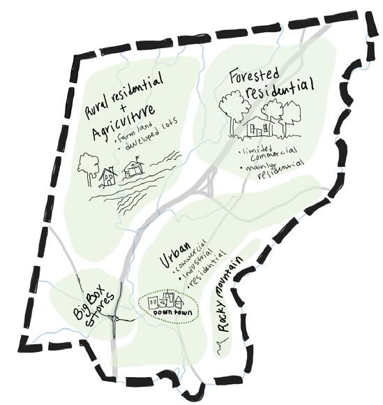
Development Patterns
Greenfield covers approximately 22 square miles (14,020 acres) and is most densely developed south of Route 2 and east of Interstate 91 (see Land Cover map on facing page). Commercial corridors extend from the downtown area along Federal Street and Main Street, and a narrow industrial district follows the train tracks north of Arch Street (see Zoning map below). Residences surround the urban core. The average lot size for a single-, two-, or three-family home in this part of town is 13,806 square feet. Nearly 72% of residential lots in this Urban Residential zone are single-family homes, and 14% are two-family homes.
North and west of Interstate 91, lower-density neighborhoods, forests, and farms make up a landscape with a more rural character. Most of Greenfield’s agricultural lands are here, along the banks of the Green River. East of Interstate 91 and north of Route 2, houses and planned industry occupy a forested matrix. In these areas, the average lot size for a single-, two-, or three-family home is about 73,000 square feet.
An industrial park may be defined as “a defined area designed to accommodate industrial and manufacturing uses” (FRCOG, “Planned Industrial Park Inventory Update,” 1). The Interstate-91 Industrial Park in Greenfield is currently zoned over 268.3 acres and hosts twenty-two businesses. At present, it contains three parcels that are “ready for development” and three parcels that are developable “with constraints.” A recent inventory notes that “there is market interest for planned industrial park space in Franklin County” (8), and the development of planned (as opposed to unplanned) industry is a form of compromise between economic and environmental values. Industries that would add to or complement Greenfield’s already robust food processing sector could be especially valuable to the city.
Zoning
Central Commercial
General Commercial
General Industry
Health Service
Limited Commercial
Planned Industry Office
Urban Residential
Suburban Residential
Rural Residential
Semi-Residential
Greenfield LU/NHC Update 14
Land Cover
Based on 2016 data from MassGIS.


Land Use
According to 2016 land use data provided by MassGIS and summarized in Greenfield’s 2021 Open Space and Recreation Plan, about 52%, or 7,285 acres, of the city is devoted to commercial, industrial, residential, or mixed use (see Land Use map on facing page). Among these use-areas, residential (multi-family and single family) land made up the largest portion with 4,323 acres (32%) and commercial the second-largest with 688 acres (5%). One can see at a glance the varied mosaic of uses in the downtown area, a legacy of the city's industrial past. The infographic below summarizes land use in Greenfield as defined by Property Tax Classification Codes.
Sum of Shape_Area by USEGENNAME
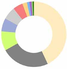

Residential 32%
Right-of-way 10%
Open Land 17%
Mixed Use 16%
Tax Exempt 9%
Commercial 5%
Agriculture 8%
Water 1%
Industrial 1%
Recreation 1%
Forest 1%
Greenfield’s open spaces–land that has not been developed for commercial, industrial, or residential use–may be identified and mapped according to ownership and level of protection from development. Approximately 2,700 acres (20% of Greenfield’s land area) may be considered open space, of which 1,548 acres (11%) are privately owned, 855 acres (6%) are City-owned, 133 acres (1%) are owned by the state, and 63 acres are owned by conservation organizations or land trusts. About 16% (2,296 acres) of Greenfield’s total land area is permanently protected (see map on page 63, Protected Open Space).
The well-defined transition from the developed downtown area to the open spaces of the Green River Valley north and west of Interstate 91 can be seen in the graphic below.

Greenfield LU/NHC Update 16
I-91
Rural to Urban Greenfield
Rocky Mountain
Residential 31.1% (17,515,729.2) Open Land 16.83% (9,483,290.1) Mixed Use 15.3% (8,623,734.2) Right-of-way 10.04% (5,657,910.7) Tax Exempt 8.5% (4,787,669.9) Agriculture 7.7% (4,338,262.5) Commercial
(2,784,869.3) Water 1.666% (938,593.3) Forest 1.562%
Recreation
Industrial 1.035% (583,206.0) Unknown 0.00000003083% (0.0)
4.94%
(879,880.1)
1.32% (743,654.1)

Land Use
Based on 2016 data from MassGIS.
Residential Land Use Trends
This map shows the increase in land area devoted to residenetial land use since 1971, most notably along corridors north and west of downtown. It combines hand-delineated land use data from 1971 and 2005 with land cover data from 2016 filtered by use.


2016 1971

Greenfield LU/NHC Update 18
Shelburne
Land Use Trends
Toward the end of the twentieth century, development trends in Greenfield favored new single-family homes on large lots. In 2014, Sustainable Greenfield noted that the amount of land devoted to low-density housing had increased in the town’s rural northern and western areas between 1971 and 2005. This increase occurred despite a decrease in the town’s population, and these homes were often built on forested or formerly agricultural lands. When construction on agricultural land occurs, it results in permanent loss of the land for agriculture; additionally, soil is often moved or destroyed.
Although the 2016 land use data is not directly commensurable with earlier data due to changes in data classification methodology, there is some evidence to suggest that this trend of development on farms and in forests continues (see map on previous page). The Conway team was able to identify at least one agricultural field that was converted into a housing subdivision between 2005 and 2016. The conversion of farmland to homes is driven by a statewide housing shortage as well as the economic needs of farmers, and zoning regulations help to determine what kinds of housing get built. While the need for housing is great, the need to address the financial security of farmers is also of paramount importance. We need farmers and farmland to ensure our food security as well as build climate resilience.
Recent Planning Efforts
Since its 2004 Community Development Plan, Greenfield has recognized and attempted to mitigate the loss of open space due to low-density residential development by favoring higher-density development in the downtown area (Sustainable Greenfield 35). That plan included a mix of housing types to suit a range of choices for both market rate and affordable units, which carried over to the city’s 2014 goals of preserving agricultural land and focusing residential and commercial development in previously developed areas.
Greenfield also completed a Downtown Master Plan in 2003 and an update, the Downtown Greenfield Revitalization Plan, in 2023. Updates to the plan related to land use include goals such as: addressing barriers to housing stock improvements, allowing multi-family development and accessory dwelling units (ADU) by right, enhancing the downtown experience through outdoor dining and cultural activities, revising zoning to encourage development through mixed-use permitting, and creating an adaptive reuse overlay district to encourage increased density and reuse of downtown space.

Greenfield LU/NHC Update 19
Climate Change
Greenfield has seen extreme temperatures, increases in precipitation, periods of drought, and extreme weather events impact its natural resources, local economy, and health of residents. Recent major meteorological events include an extreme drought in 2022 during which the city was under an outdoor watering ban and at least two severe rain events in 2023 causing flooding, damage to farmland and crops, sewage discharges into rivers, and a declaration of a state of emergency.
Recognizing the need to protect natural resources and the built environment, the Conway team has made climate change a special focus area of this update. Improving the resilience of the community and its infrastructure, supporting local agriculture, mitigating the impacts of flooding, protecting water quality, and decreasing energy use and fossil fuel use are specific goals Greenfield can pursue in response to climate change. This section summarizes some of the climate-related issues that Greenfield is facing which are also referred to throughout the document.
Resilience Building
In 2019 Greenfield was awarded a Municipal Vulnerability Preparedness (MVP) planning grant by the Massachusetts Executive Office of Energy and Environmental Affairs, and the city’s MVP Resiliency Plan was published in 2021. Greenfield, along with many other towns in Franklin County, has been certified as an MVP Community, qualifying the city to apply for and receive MVP Action Grants for projects to improve resilience to climate change.
Collaboration between the Greenfield Energy and Sustainability Department and the Franklin Regional Council of Governments to develop a Municipal Net-Zero Operations Plan further demonstrates the City’s commitment to achieve net-zero emissions in municipal operations and contribute to state and national emissions reductions targets such as the Massachusetts Clean Energy and Climate Plan for 2050 (“Greenfield Spotlights Energy Progress”).
Agriculture
Climate change is also affecting Greenfield’s farms and farmers. For example, Just Roots’ farm fields have been subjected to prolonged standing water due to heavy rains in the past few years, ruining crops or making fields unplantable altogether. Other farms in the region have seen crops and soils washed away by flooding, causing devastation to farmers and placing more pressure on the food system overall. Many farmers in Greenfield and the surrounding area have already adopted practices that are both sustainable and that enable them to better withstand climate-related stresses, and the city should support these efforts.


Greenfield LU/NHC Update 20
Precipitation and Flooding
Parts of Greenfield experience flooding when the Green River overflows its banks or when the stormwater system is inundated by a heavy rain; more erratic and extreme patterns of precipitation due to climate change will likely make flooding more frequent. During periods of drought, heavy rainfall can lead to flooding when the dry ground is unable to absorb the sudden large quantities of water.
Flooding events have reshaped the city in lasting ways. In August 2005 Greenfield received 9 inches of rain, 3 times more than the monthly average the previous year, resulting in the overflow of the Green River and flooding that caused the displacement of 75 individuals in the Wedgewood Gardens Trailer Park (Department of Public Works). Two years later, the town secured a FEMA Flood Mitigation Assistance (FMA) grant and a state Urban Self-Help grant (now known as the PARC grant) to acquire the property affected by the flooding. This funding enabled the town to acquire the land and remove the trailer park pads and utilities, effectively transforming the area into permanently protected open space, formally renamed Millers Meadow.
The presence of high groundwater levels also poses significant challenges, as many Greenfield residents experience wet basements. It is common in the more populated part of the city to see hoses running from basements and discharging water from sump pumps, and there is reason to believe that other pumps are connected directly to the sanitary sewer system. Greenfield’s wastewater treatment plant is not currently sized to accommodate the volumes of water that it receives during heavy rain events, meaning that on such occasions it must release raw sewage into the Green River. Moreover, the plant’s location in the 100-year floodplain of the Green and Deerfield Rivers presents a potential risk to public health and the environment should the plant itself flood, as it did during Hurricane Irene in 2011. Although the plant received upgrades to resist flooding in 2000 and 2014, workshop participants for the MVP Resiliency Plan “identified that this facility is still of concern and needs additional upgrades in order to build resiliency against future flooding events, and other updates are needed to reduce inflow and infiltration pressure and reduce the risk of combined waste water and storm water hazard events” (9) (see also “Water and infrastructure”).
Forests and Trees
Trees, both in an urban setting and in forests, can help to mitigate the effects of climate change while at the same time being vulnerable to those effects. Much of Greenfield is forested, and forests play an important role in sequestering carbon dioxide from the atmosphere as well as retaining water and providing valuable wildlife habitat (Harvard Forest). Some forests in Greenfield are logged, while others are at risk of being cleared for development. The City should do what it can to encourage sustainable forestry practices (see "Forested Greenfield").
Street trees (which tied for second with pollinator habitat as a “conservation priority” of community engagement participants) can also help to mitigate the effects of climate change by providing shade and lowering ground surface temperatures. They are most helpful as a climate mitigation strategy when planted in strategic locations such as by streets or parking lots. As they do in the forest, street trees can help to manage flooding and reduce runoff by aiding the infiltration of water into soil.
While it is true that trees help mitigate climate change, they are also vulnerable to the warming climate. Warmer temperatures and drought conditions during the growing season can stress trees and slow growth (EPA). The MVP Resiliency Plan notes that as temperatures rise and growing seasons increase, habitat conditions for trees in Massachusetts are shifting further north to higher and cooler elevations. This means that the “typical New England forests” will look different over time as birch, maple and beech decline and oak and hickory continue to thrive.
In many cases, warmer temperatures are also favorable to tree pests. The emerald ash borer is currently killing the green ash trees (Fraxinus pennsylvanica) that populate streets and in parks (including Main Street) in Greenfield. Meanwhile, the hemlock wooly adelgid is threatening forest populations of Eastern hemlock (Tsuga canadensis). And non-native trees that were once popular in landscaping (such as the Norway maple and the Callery pear/ Bradford pear) are escaping into the wild. Clearly, the future forests of New England will look drastically different than those of centuries ago, but the policies adopted by Greenfield today will help to determine the degree and character of this difference.
Greenfield LU/NHC Update 21
Downtown
Greenfield’s downtown combines historic charm with regional accessibility. It boasts walkability, a vibrant arts and culture scene, excellent restaurants, and an active business community. Its industrial past has moreover helped to establish a mosaic of distinct land uses and mixed-use settings that contribute to the city’s dynamism as a regional “food hub.” But like many cities across the United States, Greenfield faces the question of what a downtown area can or should be as changes wrought by online retail and other factors alter the composition of the traditional Main Street.
Despite its many assets, the downtown area currently contains a number of vacant and underused spaces that represent both challenges and opportunities. Since the publication of Sustainable Greenfield in 2014, the City has modernized its zoning use-schedules and eliminated parking minimums to promote infill development and redevelopment downtown. Further zoning reforms such as an infill development ordinance and/or adaptive reuse overlay district could make it easier to redevelop nonconforming lots, making downtown more attractive to builders while preserving its variegated character.
Another opportunity is presented by the amount of land area currently devoted to parking downtown. The 2023 Downtown Greenfield Parking Study found that there is “significant [parking] capacity available across the Downtown throughout the entire day” and that “the newer Olive Street Garage offering an updated and centralized public parking opportunity [is] far from achieving optimal utilization even during typical peak periods” (17). One online survey respondent enthusiastically echoed this idea, writing that “there is PLENTY of vacant parking lot space for new development” and continuing,
I would like to see the upper levels of downtown reused, adding residents, vibrancy, and safety to the community. With that huge parking garage I would think all the surface parking lots could be built on. The little street in front of City Hall could be greened over to make Court Square more usable and feel less like a tiny island in a sea of whizzing cars.

Greenfield LU/NHC Update 22
The respondent’s comment about green space brings up another theme that was prevalent in discussions and comments about downtown during the community engagement process: participants’ appreciation of—and desire for more—public spaces and green spaces. During the second public discussion on Zoom, “liked” responses to the question “[w]hat is working or could work to enliven community gathering spaces in Greenfield?” included “[m] ore street trees, more parklets, more pedestrian areas” and “[m]ore places to hang between businesses but not for customer use only.” Respondents also recognized that such spaces require maintenance and that, while such maintenance should not be left to volunteers alone, work by designated volunteer coordinator might help to ease the burden of maintenance on other city departments.
In addition to questions of land use, issues of transportation and access arose frequently during discussions of downtown. One member of the community expressed a wish for “affordable rail access to Brattleboro, Boston, Hartford, and Berkshire East” and “safe bike paths everywhere.” Greenfield has developed and extended several bike lanes and pedestrian walking paths since 2014 as part of its Complete Streets initiative, and it continues to do so. It is also currently piloting weekend fixed-route bus service via the Franklin Regional Transit Authority (FRTA). At several points throughout the community engagement process, participants pointed to the city’s proximity to Interstate 91 and Route 2 as advantages but stressed the need for non-vehicular access across these routes. The themes of pedestrian and bicycle access are touched on in more detail in the “Recreation” section of the “Natural, Historic, and Cultural Resources” chapter and will be treated more fully in an updated “Transportation” chapter of the comprehensive plan.
The 2023 Downtown Greenfield Revitalization Plan further addresses matters related to the downtown area.
 Downtown Main Street Holiday Lights
Greenfield LU/NHC Update 23
City of Greenfield, 2022
Housing
The topic of housing will be treated fully in a separate updated chapter of the master plan. However, housing was identified as Greenfield’s number one “development priority” by community engagement participants, and decisions about land use (such as zoning) may affect the availability and accessibility of housing. Many residents said that Greenfield needs more affordable and accessible (barrier free) housing and that efforts to meet this need should also prioritize the conservation of natural resources and open space. As one person put it,
Safe & affordable housing is clearly an issue. I would like to see Greenfield address this in a way that still preserves our forests, pollinator habitats, farms, and our need for reduced greenhouse gases. Trying to create a healthy and resilient community/natural environment needs to be at the heart of any plans around housing.
Another community member stated that “Greenfield does not have enough affordable housing,” while a third noted the need for “[a]ccess to safe and affordable housing for unhoused, low income, and mobility limited people.” A recent article in The Recorder interviewed three seniors who are currently struggling to find housing in Greenfield. “Anybody who knows anything about housing knows it’s bad,” one of the individuals profiled in the article said; “[e]ven if you are wealthy, it’s a challenge to find the housing that you’re looking for, even if you’re able-bodied. If you have a disability, it’s extremely difficult to find housing that’s got even minimal accessibility” (qtd. in Bhat).
The need for housing in Greenfield reflects nationwide trends. According to the Federal Government Accountability Office, “land prices increased 60% from 2012-2019, and the cost of homes more than doubled from 1998 to 2021.” Rents also increased “about 24%” from 2020 to 2023. In the Pioneer Valley, home prices rose 6% between October 2022 and October 2023 to a median of $335,000. 608 homes were listed for sale in October 2023, down from 902 a year earlier (MacLean).
According to the Greenfield’s 2023-24 Community Preservation Plan,
An estimated 69% of Greenfield renters pay over 30% of their income on housing, and are considered cost-burdened. This is a much higher rate of cost-burden among renters than in the State, where an estimated 46% of renters pay too much for housing. Even more striking, an estimated 21% of renters are paying more than 50% of income on housing (considered severely cost-burdened). Greenfield’s percentage of cost-burdened homeowners is much less, at 29%, but is still higher than the State rate of 27% (32).
The Greenfield Housing Authority (GHA)
Established in 1946, the GHA offers a range of housing options for low-income individuals and families, senior citizens, and those with special needs. It developed 72 units of Veterans housing in 1949 and has since expanded its scope of operations. The Winslow Building, with 55 Single Room Occupancy (SRO) units, provides affordable and convenient living in proximity to downtown for individuals aged 18 and above, including those who are elderly, disabled, or working. The GHA also participates in revitalization programs for downtown properties such as SHARP, Core Focus, and 705 Moderate Rehab. It is currently developing five new affordable housing units at 300 Conway Street (Greenfield Housing Authority).

Greenfield LU/NHC Update 24
The Winslow Building
Since 2014, the city has sought to increase housing availability and density through zoning reforms. It has allowed attached Accessory Dwelling Units and two- and three-family dwellings by right in all residential districts, and it has taken measures to improve housing access for vulnerable populations. Multiple housing projects are currently underway, including the renovation of Wilson’s Department Store and 300 Conway Street. Non-profits have also stepped in to help fill gaps; in April 2023, the Zoning Board of Appeals issued a special permit for a 36-unit permanent supportive housing complex at 60 Wells Street, a partnership between Rural Development, Inc., and Clinical & Support Options, Inc (Rural Development, Inc.). While these measures represent progress, further opportunities exist to expand and diversify Greenfield’s housing stock through zoning policy changes.
To encourage more housing downtown, the City could consider more permissive regulations for multifamily units. Multifamily units are currently allowed by right only in the Central Commercial zone; elsewhere they require a special permit, which is a significant deterrent to developers. Greenfield could expand by-right (pending site plan review) development of multifamily units to the Semi-Residential zone, which adjoins the Central Commercial zone. Alternatively, or in addition to this measure, the current limit of 24 units in new multifamily dwellings could be raised. Measures to allow easier redevelopment of nonconforming lots could also provide opportunities for more housing. Strategies that focus on downtown have the virtue of encouraging new housing near existing infrastructure (such roads and utilities) and public services (such as schools, libraries, and hospitals). Within the Urban Residential (RA) zone, the city could look for ways to encourage single-family to two- or three-family conversions.
In more rural areas, Open Space/Cluster Developments (also called Conservation Subdivisions) represent a mechanism by which construction of housing may be paired with permanent conservation of open space. While Greenfield has an Open Space ordinance, the City could consider amendments that make open space developments more attractive to builders and/or more effective at conserving agricultural and forested lands. Such measures could include density bonuses for affordable housing and increased protection of open space, smaller lot sizes, or greater open space requirements in rural districts.
A final tool that the City could explore is a Transfer of Development Rights (TDR) program that would allow landowners to sell development rights from one area (often rural or sensitive land) to developers in another area where growth is encouraged. Such programs are designed to protect rural areas by directing development to more suitable locations. As a preliminary measure, the City could investigate whether there are zones within Greenfield that would benefit from such an arrangement.

Conventional Development Versus Cluster Development
Greenfield LU/NHC Update 25
Water Quality and Stormwater Infrastructure
Quality of Greenfield’s waterways as assessed in compliance with the Clean Water Act, municipal stormwater network, and 100-year flood zone.
BERNARDSTON ROAD
MOHAWKTRAIL
FEDERAL STREET
HIGHSTREET
MAIN STREET
GREENFIELDROAD

Greenfield LU/NHC Update 26
SOSTREE
FRENCHKING HIGHWAY 2A 5 5 2 5 5 5 2A 2A 2 91 91 91 Library High School Poet Seat Swim Area 0 1.5 3 0.75 Miles ¯
Water and Infrastructure
The waters that flow through Greenfield and the city’s water infrastructure make up an integrated system. The health of the city’s waterways (both their ability to support natural communities and their safety for human purposes such as fishing and swimming) depends in part on how its infrastructure functions, and this function depends in turn on “upstream” inputs such as rain. Factors to consider when making decisions about land use that relate to water and infrastructure include residents’ desire to conserve and restore the city’s waters (water was the most chosen “conservation priority” among community engagement participants) and the effects of climate change, notably the likelihood of more frequent heavy rains (Crimmins et. al.) and the possibility of migration from coastal areas (OSRP 3-13).
Another important factor is the state of the city’s infrastructure. As in many other cities and towns across the United States, elements of Greenfield’s sewer and stormwater networks are old and deteriorating. Some segments of the sewer were laid more than a century ago and have since shifted, making them vulnerable to inflow and infiltration. Illicit connections from residential sump pumps also burden the system. During heavy rain events, the volume of water in the system increases greatly, making it necessary to release sewage into the Green River. Not only this, but streets are frequently closed in Greenfield as the Department of Public Works responds to and repairs broken and collapsed pipes. To fully repair the sanitary sewer network would require lining many pipe segments and replacing others according to an official from the Department of Public Works.
The town’s stormwater system is also due for an overhaul. Many of its culverts are too small to accommodate peak discharges during heavy rain events, meaning that parts of the city experience localized flooding (Multi-Hazard Mitigation Plan Update Committee 35-6; MVP Resiliency Plan 9). It is common for streets such as Nash’s Mill Road and Arch Street to be closed due to flooding. Even when the stormwater system functions as intended, stormwater flows untreated from impervious surfaces into the Green River and other waterways carrying pollutants and sometimes heat, which degrade water quality. It is possible to mitigate these effects by incorporating “green infrastructure” into system upgrades when opportunities allow (see “Green Infrastructure” box).
The Clean Water Act
Under the Clean Water Act, states are required to monitor waterways with respect to their ability to support human uses and aquatic life. Waterways are assigned a Class that specifies the uses they must support as well as a Category based on their ability to support those uses. Class A waters must be able to supply drinking water, while Class B waters should allow recreation and ecosystem function but not necessarily be drinkable. All of the monitored waterways within Greenfield are Class B. The Categories are summarized by MassGIS as follows:
Category 1) Unimpaired and not threatened for all designated uses.
Category 2) Unimpaired for some uses and not assessed for others.
Category 3) Insufficient information to make assessments for any uses.
Category 4) Impaired for one or more uses, but not requiring the calculation of a Total Maximum Daily Load (TMDL).
Category 5) Impaired for one or more uses and requiring a restorative “action” plan, such as a TMDL or Alternative Restoration Plan (impairment due to pollutant(s) such as nutrients, metals, pesticides, solids, and pathogens).
(MassGIS Data: MassDEP 2022 Integrated List of Waters (305(b)/303(d)))
Waterways are reevaluated every few years. In 2022, the Green River south of Swimming Pool Dam was evaluated at Category 5; specific impairments of this stretch included E. Coli, Fecal Coliform, Lack of a Coldwater Assemblage, Temperature, and Turbidity. It should be noted that while the Green River above Pumping Station Dam/Eunice Williams Covered Bridge was also evaluated at Category 5, it is a Class A waterway and was considered impaired only because of temperature (Watershed Planning Program).
Greenfield LU/NHC Update 27
River Corridor
While rains are the primary driver of flooding downtown, flooding also occurs along the banks of the Green River. The Green River Swimming and Recreation Area flooded during Tropical Storm Irene in 2011 (MVP Resiliency Plan 44-6) and, according to members of the community, continues to experience significant flooding. Other low-lying areas along the river also flood regularly (35-6). The city currently plans to reduce flooding and erosion along the river through measures such as bank stabilization, planting native trees and shrubs, developing and implementing a knotweed eradication plan at Millers Meadow, and repairing the retaining wall at the Recreation Area. It also currently recognizes a Floodplain overlay district based on the “one percent annual chance flood” as defined by FEMA’s Flood Insurance Rate Maps from 1980—that is, the elevation that water is expected to reach in a 100-year flood; however, these maps underestimate the actual current frequency of flooding and do not take into account fluvial erosion hazards that are related to, but different from, flood hazards.
Fluvial erosion hazards—streambed and streambank erosion that can occur during flooding—are of particular concern in this part of New England. A history of land clearance and development along rivers, in connection with attempts to control flooding through techniques such as straightening the river channel and constructing berms, has led to “an escalating cycle of increasing flood damages and costly repairs” (FRCOG). A different approach to managing flood hazards is to recognize and accommodate a river’s natural movement within its “corridor”: “the area of land surrounding a river that provides for the meandering, floodplain, and the riparian functions necessary to restore and maintain the naturally stable or least erosive form of a river thereby minimizing erosion hazards over time” (UMass Amherst Extension). In 2019, the Franklin Regional Council of Governments prepared a corridor map of the Green River as well as a model River Corridor Protection Overlay District Zoning Bylaw; adopting a zoning overlay district based on this map and model bylaw could help Greenfield to better manage current erosion hazards and avoid such hazards in the future. Given that much of the riparian lands that are valuable to the community as flood storage are privately owned, this overlay district could work in tandem with efforts to mitigate flooding through River Corridor Easements (RCE) or Conservation Restrictions (CR) in particular areas.


Greenfield LU/NHC Update 28
Shelburne Road Culvert Failure Greenfield DPW, 22 March 20224
Flooding on Arch Street City of Greenfield DPW

example river corridor map showing channel migration and flow paths (Not an official delineation, for illustration purposes only.)
Greenfield LU/NHC Update 29
The term “green infrastructure” originally referred to natural landscapes (forests, wetlands, etc.) that filter or absorb stormwater. Over time, it has grown to include engineered systems that supplement or replace traditional “gray infrastructure.” While gray infrastructure is designed to convey water away from the built environment as quickly as possible, green infrastructure is designed to slow and hold water in vegetated areas that mimic natural systems. The Water Infrastructure Improvement Act (2019) defines green infrastructure as “the range of measures that use plant or soil systems, permeable pavement or other permeable surfaces or substrates, or landscaping to store, infiltrate, or evapotranspirate stormwater and reduce flows to sewer systems or to surface waters” (EPA, “What is Green Infrastructure?”).
GREEN INFRASTRUCTURE

Green Roof
A green roof is a vegetative layer installed on a rooftop. A vegetated growing medium helps to slow the velocity of stormwater runoff and reduces the total amount of runoff. Other benefits of green roofs include natural air and water filtration, reducing temperature, and functioning as insulation. Green roofs can also attract beneficial insects and birds (EPA, “Using Green Roofs to Reduce Heat Islands”). Green roofs in densely developed urban environments are especially beneficial for mitigating the heat island effect and reducing runoff.

Rain Garden
Rain gardens, or vegetated basins, are designed to temporarily collect, store, and absorb surface water runoff from rooftops, driveways, sidewalks, parking lots, lawns, and other impermeable surfaces. A garden of deep-rooted shrubs, grasses, or flowers, planted in a small depression below a slope, builds soil structure while infiltrating and recharging groundwater (Groundwater Foundation). Rain gardens are ideal for private spaces such as lawns or public spaces such as parking lots. They may be constructed around existing storm drains. A rain garden planted with native plants not only provides an attractive alternative to a turf detention basin but also supports pollinators and other wildlife.
Greenfield LU/NHC Update 30
Green infrastructure elements may be incorporated into a community at different scales. Site-scale examples could include a rain barrel, a rain garden, a green roof, or a permeable sidewalks or parking lot. Neighborhood-scale examples could include a row of trees or a bioswale along a street, a park, a constructed wetland, or stream daylighting (renovating existing infrastructure to restore ecosystem function). “When green infrastructure systems are installed throughout a community, city or across a regional watershed, they can provide cleaner air and water as well as significant value for the community with flood protection, diverse habitat, and beautiful green spaces” (EPA, “Green Infrastructure”).
Like traditional “gray infrastructure,” green infrastructure must be properly designed and maintained to fulfill its intended functions. For example, engineered wetlands often require a sediment-capture mechanism that must be emptied periodically. Maintenance may require the identification of, and care for, plants (especially if native plants are desired). When properly designed and maintained, green infrastructure will aid in the management of stormwater, improve water quality, offer habitat for wildlife, and provide shade and lush greenery for human enjoyment.

Pervious pavement
Pervious pavement may be installed in place of traditional asphalt or concrete parking lots, sidewalks, paths, or streets to infiltrate water rather than shedding it as runoff. Compared to traditional pavement, alternative materials allow rain and snowmelt to filter through layers of rock, gravel, and soil. Subsurface pipes may be installed to rout water to a storm sewer or natural channel. Permeable pavements could lower construction costs for some projects by reducing the need for conventional drainage features (EPA, “Soak Up the Rain).

Bioswale
Bioswales, or vegetated channels, are linear swales designed to slow and infiltrate surface water runoff from nearby impervious surfaces before it is routed into storm sewers, natural channels, or groundwater. Plants and soil microbes break down pollutants and improve water quality while reducing the volume of water entering drainage systems. Flexible siting requirements mean that bioswales may be integrated with medians and curbs, greening the streetscape while taking pressure off of existing infrastructure (NACTO, “Urban Street Design Guide”).
Greenfield LU/NHC Update 31
Solar Energy
Greenfield has made great strides in reducing greenhouse gas emissions and has ambitious goals in place to complete the transition to nearly carbon-free electric power by 2050. The city’s municipal operations have achieved significant reductions in greenhouse gas emissions since 2008 (including a 39% reduction in emissions from electricity and a 96% reduction in emissions from heating oil, as detailed in the Net-Zero Operations Plan). In 2012, the City installed a 2 megawatt solar farm on its capped landfill. Since 2014, Greenfield has also seen 500 kilowatts of rooftop solar added to homes and businesses, construction of a 1.2 megawatt solar farm on the City’s wellfield in 2021, opening of the new zero-net-energy-ready library with a solar array, and a donation from a private resident to install a rooftop array on the DPW office in 2023. The John W. Olver Transit Center, built on a brownfield site in 2012, includes a ground-mounted photovoltaic array.
So far, Greenfield has avoided major sacrifices of its natural and working lands to solar installations. Not all places have been so fortunate. A 2023 report by MassAudubon and Harvard Forest, Growing Solar, Protecting Nature, reveals that “[s]ince 2010, ground-mount solar has displaced at least 1,800 acres of high biodiversity lands and nearly 1,300 acres of farmland” (Executive Summary 3). But as MassAudbon states on its web page for the report,
Every acre of forest destroyed is a huge loss for birds and other wildlife, clean air and water, natural beauty, and recreation. But most importantly, cutting forests and developing farmlands to build solar energy doesn’t make sense for the climate: natural ecosystems and farm soils absorb 10% of Massachusetts’ greenhouse gas emissions every year. Both nature conservation and solar energy must be treated as essential strategies in our response to the climate crisis.
During the second community engagement session facilitated by the Conway team, participants expressed their desire to grow solar and while also protecting open space. Participants were asked “[w]hich statement best expresses your attitude toward new solar?” and given the following three choices: “[a]s much as possible, anywhere”; “[m]aintain urgency, but prioritize roofs and parking lots”; and, “I don’t think we need more solar.” Twenty-four out of twenty-six respondents chose “[m]aintain urgency, but prioritize roofs and parking lots.”
Growing Solar, Protecting Nature identifies priority areas for solar energy development based on factors such as solar potential, land availability, and compatibility with conservation goals. By strategically siting solar installations on already disturbed or less ecologically sensitive lands, the report suggests ways to minimize the loss of forests and agricultural lands to solar development. Greenfield already restricts by-right development of commercial-scale solar arrays to the General Industry and Planned Industry zones. They are allowed by special permit in several other zones. By taking habitat and conservation values into account when deciding whether or not to grant a special permit, and by continuing its already-strong efforts to site solar on already-developed or disturbed environments, Greenfield can continue to be a leader in solar best practices.

Greenfield LU/NHC Update 32
Solar on DPW offices
Paul Franz, 2023
Conclusion
Decisions about land use have shaped Greenfield's landscape today for better and worse. Planning a future that respects history while encouraging sustainable growth means taking seriously the missteps of the past and the challenges of the present, especially climate change.
This update’s vision for Greenfield is rooted in an appreciation of its natural and historical context, from ancient geological formations to the long tenure of Indigenous stewardship and more recent industrial uses. By acknowledging and learning from this heritage, the community can forge a path forward that respects the interconnectedness of human activity and the natural world.
Encouraging the concentration of development and redevelopment in already-developed areas and protecting wild and working open spaces are important measures to reduce environmental impacts and encourage the city’s resilience.
Through a coordinated effort guided by thoughtful planning, sustainable development practices, and a commitment to environmental stewardship, Greenfield can build upon its already considerable progress toward becoming a sustainable community, moving toward a future in which human well-being is further enhanced by wise use of natural abundance. The Recommendations section at the end of this document lists some strategies that may aid in this effort.
Greenfield LU/NHC Update 33

2014 Sustainable Greenfield Natural, Historic, and Cultural Resources Goals
Greenfield’s natural, historic, and cultural resources will be an integral part of the town’s identity with wider recognition and use.
Residents and visitors of all ages will enjoy various recreational opportunities as a vital contribution to their health and wellbeing.
Our natural world and the scenic, rural, and agricultural landscapes will be protected, preserved, and improved to support biodiversity and healthy living in Greenfield.
Greenfield’s cultural life will be encouraged, expanded, and better promoted, with more established town-wide events.
Greenfield LU/NHC Update 34
Annual community supper
Kirsten Levitt, 2018
Natural, Historic, and Cultural Resources
Landscapes and Identities
Greenfield’s identity as a community is intimately tied to the land itself and the histories of the peoples who have lived here. We recognize that the first peoples of this land were Indigenous, and we seek to learn from their example in our care for, and stewardship of, the land. We seek to enrich, not degrade, the land’s soils, waters, and biodiversity in our work and recreation. We recognize the value of telling and retelling the stories of those who have lived here in order to understand and reconcile our kinship through the land. We also recognize the value of conserving historically significant places that we love.
Greenfield’s character as an Indigenous settlement or gathering place, its subsequent development by colonizers as an agricultural center and mill town, and its responses to the upheavals of globalization and e-commerce all reflect, to one degree or another, regional and even national experiences. Climate change may also bring disruption on a grand scale. But along with its experience of these broad trends, Greenfield is also defined by a particular landscape and the lives of those who have passed through it. Stories and events such as the tale of the Great Beaver, the killing of Eunice Williams for whom the Eunice Williams Bridge is named, construction of the first bridge over the Connecticut River to Montague, the Greenfield Recorder beginning its publication, the opening of the Greenfield Energy Park, and the January 2017 Women’s Rally contribute to a unique and distinct local history. Greenfield’s natural, historic, and cultural resources are not “resources” in a generic sense but rather those things that confer upon Greenfield its identity as a community.
Experiences of the land itself are an especially important “resource” in this sense because they are one of the things that the land’s pre-colonial inhabitants and those who came after share. As stated in the city’s Open Space and Recreation Plan,
[T]he history of Greenfield—how people came to settle the land, use its resources, and enjoy its forests, streams, and bodies of water—can be seen in the landscapes that have retained a sense of the past. The unique environments in Greenfield play a very important role in providing residents with a sense of place. Brooks, mountains, wetlands, and City centers provide markers on the landscape within which we navigate our lives. (4-42)
Greenfield’s present-day inhabitants have come to recognize and value these natural markers. Groups such as Greening Greenfield and the Greenfield Tree Committee are working to cultivate reciprocity between Greenfield’s natural landscapes and human communities, while organizations such as the Nolumbeka Project are advancing public recognition of those who have been here the longest. These efforts deepen and contextualize the work that has already been done to preserve and celebrate Greenfield’s recent history by organizations such as the Greenfield Historical Society and the Museum of Our Industrial Heritage.
Along with its cultural “resources,” Greenfield also possesses resources in an economic sense. Positioned at a regional crossroads connecting New York to the south and Vermont to the north, and the Berkshires and Boston east and west, Greenfield functions as a commercial hub amidst valuable natural landscapes. Sustainable Greenfield describes the city as “a community with numerous and varied cultural amenities in a beautiful historic setting, with ready access to the rivers and fields, woods and hills of the Pioneer Valley and the recreational opportunities they provide” that “capitalize[s] on these assets to attract visitors and new residents, as well as retaining existing residents.” Indeed, Greenfield’s natural and cultural assets are boons to those who live here. The following analyses and recommendations aim to outline ways in which residents of Greenfield might further enrich, rather than diminish, these natural and cultural assets in their work and recreation, and so approach the goal of “sustainability” established in the 2014 plan and continued in this update.
Greenfield LU/NHC Update 35
Geology, Aquifers, and Soils
Greenfield occupies a low glacial outwash plain between the Connecticut River to the east and the Berkshire Highlands/Southern Green Mountains to the west. When Glacial Lake Hitchcock filled the Connecticut River Valley during the last Ice Age, all of present-day Greenfield was underwater. Streams flowing into Lake Hitchcock from the surrounding highlands carried stony debris that settled out as they entered the lake, forming deep sand deposits in northern Greenfield. Today, these sand deposits hold water and function as aquifers for Greenfield and surrounding towns. The process of sediment deposition was further modified by beavers and Indigenous land use practices, generating rich soils suitable for agriculture.

Bedrock
The deposition of glacial sediments took place between 10,000 and 20,000 years ago, but the bedrock under these deposits is much older. Greenfield’s bedrock (and the rock under much of the river valley to the south) can be classified as arkose, a type of sandstone. It formed over millions of years as the floor of an inland sea (Sustainable Greenfield 148). At some point, an outpouring of basalt lava covered some of this arkose to create Rocky Mountain, which rises abruptly between downtown Greenfield and the Connecticut River. Columns of basalt and rocky outcroppings of rose arkose can be seen most readily in Highland Park and along the Pocumtuck Ridge. The basalt continues under what is now called the Pocumtuck Range, which stretches from Rocky Mountain to Mount Sugarloaf in Deerfield, and which takes its name from the Pocumtuck people.
30' Contours
Surficial Geology
Sand and Gravel
Till or Bedrock
Fine-Grained Deposit
Floodplain Alluvium
Depth of Surficial Deposit
200'+
Aquifers
30' Contours
High yield
Medium yield
Surficial Geology
Sand and Gravel
Water Supplies
Till or Bedrock
Public well
Fine-Grained Deposit
Surface water supply
Floodplain Alluvium
Prime Soils
Depth of Surficial Deposit
Topography, Surficial Geology, Aquifers, and Soils (facing page) Greenfield’s low position relative to the surrounding hills can be seen in the map on the top left. Sand and gravel carried by streams entering Lake Hitchcock settled into deep surficial deposits (top right), many of which now function as aquifers (bottom left). Greenfield’s prime soils are made up of even finer sediments deposited by floodwaters and trapped by beavers along the Green River and other waterways.
50'-100'
All areas are prime farmland
100'-200'
200'+
Farmland of statewide importance
Wetlands
Aquifers
High yield
Medium yield
Water Supplies
Public well
Surface water supply
Prime Soils
All areas are prime farmland
Farmland of statewide importance
Wetlands
Greenfield LU/NHC Update 36
100'-200'
50'-100'
¯ 0 1 0.5 Miles
Forested Greenfield
Forests and trees provide valuable wildlife habitat and ecosystem services. Conserving forests and greening the urban environment will help to ensure the long-term viability of Greenfield’s economy, the city’s comfort and attractiveness for its human residents, and biodiversity (see also “Connectivity Planning and Conservation”).
Forests
Massachusetts forests are home to diverse plant and animal species, including rare and endangered species, and forested watersheds in Massachusetts provide clean drinking water to millions of people. Forests also capture and store carbon in soils, trees, and associated organisms. In 2016, approximately 55% of Greenfield was “forested” according to land cover data, although the amount of contiguous forested habitat was significantly less—perhaps 33%. Most forested areas are located along Greenfield’s northern and western borders as well as on Rocky Mountain and in isolated patches between neighborhoods and farms.
Greenfield’s publicly-accessible forests, in addition to serving the above-mentioned ecological functions, are cherished for recreational activities such as walking, snowshoeing, and nature exploration. Highland Park, Temple Woods, and the Griswold GTD Conservation Area all contribute significantly to the city’s beauty and natural abundance.
i-Tree, a software tool developed by the USDA Forest Service, Davey Tree and other partners, estimates the quantitative values of ecosystem services provided by trees in any given location. According to i-Tree’s “OurTree Benefits” assessment, Greenfield’s forested acreage currently sequesters approximately 355,281 tons of carbon or 1,302,697 tons of “CO2 equivalent” with an annual uptake of 6,262 tons of carbon or 22,960 tons of “CO2 equivalent.”
One potential hazard associated with forests is fire. While Greenfield’s Hazard Mitigation Plan finds the city’s vulnerability to wildfires and brushfires to be “Low” (129), an increased frequency of drought due to climate change may increase this risk, especially in “intermix” or “interface” zones where forests and human uses commingle. The plan calls for the identification of “City-owned forested areas that are at higher risk for wildfires (near industrial manufacturing, residential areas, high-wire utilities, etc.) to implement forest management practices that reduce the risk of fire hazards (such as the removal of slash)” (239).
Chapter 61 of the Massachusetts General Laws pertains to forestry. In Massachusetts, owners of forested tracts larger than ten acres have the option to enroll in Chapter 61, which requires landowners to create and adhere to a ten-year forest management plan. Property taxes are assessed at a rate commensurate with a parcel’s value as forest land for the duration of the plan, and the city or town enjoys the right of first refusal should a parcel go up for sale. Currently, forty-two parcels covering 763 acres are enrolled in Chapter 61 in Greenfield.
While a ten-year plan may result in better outcomes than no plan, ten years is still significantly shorter than the thirty-to-seventy-year period during which a forest achieves its highest rate of carbon sequestration or the roughly 200-year period after which it has achieved maximum sequestration (Catanzaro and D’Amato). Accordingly, forest management practices that are currently permitted under Chapter 61 such as patch-clearing or high-grading may yet be incompatible with the state’s climate goals. Other techniques such as “worst-first” tree selection and horse logging promoted by organizations such as the Pennsylvania-based Foundation for Sustainable Forests may constitute more economically and ecologically sustainable forms of forestry than those currently permitted in Massachusetts under Chapter 61 and, given the climate crisis, landowners and municipalities should advocate for a statewide forestry program that recognizes the desirability of these regenerative techniques (Berry).
“The second highest natural resource goal in the Franklin County 2035 Regional Plan for Sustainable Development (RPSD) is to protect forests. Unfragmented forests and forests that support rare and endangered plant and animal species are ecologically valuable, especially in the face of accelerating climate change impacts. Forests along rivers and streams are also a priority to protect for their important habitat, water recharge functions, and bank stabilization. The plan lists several potential impacts on forests due to climate change, including decline of maple syrup production, the deterioration of the Eastern Hemlock, and the spread of invasive insect species.” (OSRP 4-29)
Greenfield LU/NHC Update 38
Tree
Canopy in Greenfield
Percent tree canopy coverage for Greenfield, derived from satellite imagery and produced by the USDA Forest Service (2021).


Tree Canopy and Environmental Justice Communities
Environmental Justice data is based on demographic criteria developed by the Executive Office of Energy and Environmental Affairs (EEA).
Street Trees
While there is no substitute for large healthy forests as wildlife habitats and sources of wood, individual trees and groups of trees may greatly improve the comfort and resilience of the built environment. Street trees, which tied for second place as the most popular “conservation priority” among community engagement participants, serve multiple functions such as reducing runoff and minimizing wind force during storms, providing shade during heatwaves, and buffering noise. Trees also beautify neighborhoods, providing more pleasant conditions in which to bike or walk.
In 2014, Greenfield conducted a Public Tree Inventory that revealed a lower density of trees in Environmental Justice (EJ) areas than in the rest of downtown area. Fewer trees can mean relatively higher summer cooling costs, relatively lower property values, a decreased sense of well-being among residents, and diminished natural beauty. Notably, 51% of inventoried trees were Norway maple, and only one-third were native species. Recommendations included implementing an aggressive street tree replanting plan and public education on tree value (Sustainable Franklin County).
In 2020, the Greenfield Tree Committee (GTC) conducted another inventory and health assessment of street trees in the greater urban core. Of the 752 trees inventoried in 2014, one third had been removed, confirming that “public street trees in Greenfield have been in serious decline” (Chicoine 4). Most of the removed trees were “old, deteriorating Norway maples” (14), a non-native species that spreads aggressively once established; their loss therefore represented both a challenge and an opportunity. With help from a US Forest Service Grant, over 700 primarily native trees have been planted by the Greenfield Tree Committee and the Department of Public Works between 2018 and 2024. The grant also helped finance the startup of the Tree Committee’s nursery, an all-volunteer venture that grows primarily native trees and their cultivars for planting at no cost to the city in public spaces. The nursery produces approximately 75 to 100 trees per year (GTC). The following two pages include infographics produced by Greenfield Tree Committee that summarize the accomplishments of the grant.
Recommendations of the Tree Committee’s 2020 Inventory included planting native trees citywide, boosting municipal funding for tree planting and maintenance, prioritizing shade trees over small-stature ones, requiring street and sidewalk maintenance to include tree planting, and identifying areas for plantings to mitigate stormwater flow. These recommendations are still valuable. Along with requesting funding for tree planting in grant applications for sidewalk and street initiatives to ensure that trees are included, public outreach about the benefits of street trees and efforts to involve residents in caring for trees and green spaces should continue. By strategically incorporating trees and vegetation into the urban landscape, Greenfield can not only mitigate the impacts of climate change and improve biodiversity but also create healthier and more enjoyable environments for their residents.
In addition to these efforts, the city and volunteer groups also need to remain flexible in response to the challenges posed by species movement and climate change. As the climate continues to warm and tree pests continue to globalize, some species will inevitably fare better than others. In order to maximize the benefits associated with street trees and minimize maintenance costs, future tree-planting efforts should proactively assist the migration of species and prioritize planting in places where trees are likely to thrive. In some places, other types of plantings such as rain gardens may prove more resilient than trees.
In 2022, the City of Greenfield revised its List of Approved Trees for City Tree Planting which guides tree removal and planting in Greenfield, names approved trees for planting on City-owned land and right-ofway, and states that “no tree identified as an ‘invasive species’ shall be planted under any circumstances.” Additionally, this list provides information about the insects, birds, and mammals supported by each species. This list should continue to be updated and revised as the environment changes.
Environmental Justice
“The fair treatment and meaningful involvement of all people regardless of race, color, national origin, or income, with respect to the development, implementation, and enforcement of environmental laws, regulations, and policies.” (EPA. “Environmental Justice?”)

Greenfield LU/NHC Update 41

Greenfield LU/NHC Update 42
Greenfield Tree Committee

Greenfield LU/NHC Update 43
Greenfield Tree Committee
Water Resources
Based on input from residents at the first community engagement session facilitated by the Conway team and the accompanying online survey, water is a top priority for Greenfield residents. Greenfield’s water resources include four major rivers that flow through and around town—the Fall, Green, Deerfield, and Connecticut—and their tributaries; extensive wetlands, particularly around the Green River, Mill Brook, and Cherry Rum Brook; and Highland Pond, a beloved community gathering place (see “Recreation”). They also include a subsurface aquifer that provides about 45% of the city’s water supply (OSRP 3-22). Participants expressed interest in protecting the city’s wetlands from development and stewarding its waterways by removing invasive species and planting native vegetation. They also sounded off about hot-button issues such as the fate of dams on the Green River.
Wetlands
Wetlands Protection Act (M.G.L. Ch. 131 §40) regulations (310 CMR 10.00) define bogs, swamps, marshes, and wet meadows that border water bodies as Bordering Vegetated Wetlands (BVWs), characteristics of which include hydric soils and plants adapted to tolerate periodically saturated conditions (Jackson et. al.). These regulations recognize the value of BVWs for protecting public and private water supply, groundwater supply, flood control, storm damage prevention, pollution prevention, fisheries, and wildlife habitat, to which we might add their ability to capture and store carbon; unlike forests, which become saturated with carbon after several centuries, wetlands sequester carbon in their anaerobic soils for as long as they are allowed to function (although this carbon may be released back into the atmosphere if they are drained and their formerly hydric soils exposed to air). Wetlands in Massachusetts cover a total of 590,565 acres and store more than twice the amount of carbon per acre than forests, highlighting their importance for climate goals (Zaltzberg-Drezdahl et. al. 49).
Massachusetts has been a national leader in its protection of wetlands, and the most recent edition of Mass Audubon’s Losing Ground even states that wetlands have grown by 2,221 acres between 2012 and 2017 (2). Currently, approximately 6 percent of Greenfield is covered by wetlands, amounting to 844 acres and excluding open water. Deciduous swamp wetlands constitute the majority of wetland resources in the city.
Greenfield’s Wetlands Protection ordinance, last amended in 2016, builds upon state regulations to include a twenty-five-foot “No Disturb Zone” around Resource Areas and to clarify other matters related to wetlands and the floodplain. One question that has arisen about this ordinance in recent years is whether it restricts activity intended to improve the function of Resource Areas. WPA regulations (310 CMR 10.02(b)(2)) explicitly allow “[p] lantings of native species of trees, shrubs, or groundcover” within a buffer zone, but does this permission extend to the twenty-five foot “No Disturb Zone” established in Greenfield? The 2021 FRCOG publication Identifying and Expanding Wild Pollinator Habitat in the City of Greenfield seems to imply that it does not when it suggests revising the ordinance “with language that advocates for the care and the planting of recommended beneficial plants in jurisdictional areas” (15). This suggestion raises the question of whether the ordinance, while amplifying the protections required by the state, also permits and encourages citizen involvement in ecosystem restoration—or whether protection is understood by the city solely as a matter of non-intervention.

Greenfield LU/NHC Update 44
M. Chicoine, 2018
Wetland at Greenfield Community College
2016 MassGIS Land Cover and Land Use
Land Cover Acres
Palustrine Forested Wetland 711
Palustrine Emergent Wetland 96
Palustrine Scrub/Shrub Wetland 32
Palustrine Aquatic Bed 5
Total 844
Greenfield LU/NHC Update 45
Greenfield LU/NHC Update 46 0 1 2 0.5 Miles ¯
Wetlands
Rivers and Streams
Potential Vernal Pool
Certified Vernal Pool
Wetlands and Vernal Pools

Vernal Pools
Vernal pools are important breeding grounds for amphibians. These ephemeral pools occur in locations where small woodland depressions, swales, or kettle holes collect spring runoff and/or intercept elevated groundwater tables seasonally. Their intermittent drying is essential to prevent fish establishment, ensuring the reproductive success of amphibians and invertebrates that are dependent on fish-free breeding habitats. Mass Audubon notes that vernal pools may be destroyed by development and are often overlooked during wetland identification on construction sites due to their intermittent dry periods (“Vernal Pools”). Even disturbed areas around vernal pools affect their function; the removal of surrounding forest during construction can significantly degrade these pools by increasing sediment in runoff, interfering in species migration routes, increasing runoff contamination pollutants, and causing temperature fluctuations, potentially resulting in the elimination of the amphibian population. Careful stewardship is needed to maintain these unique habitats, especially given the further environmental fluctuations that are occurring due to climate change.
Currently, Greenfield has four NHESP certified vernal pools and about 35 potential vernal pools according to a NHESP analysis (“MassGIS Data: NHESP Potential Vernal Pools”). Certified vernal pools, meeting Natural Heritage and Endangered Species Program criteria, receive protection under the Massachusetts Wetlands Protection Act and various other state and federal regulations (“Vernal Pool Protection”), and the Natural Heritage and Endangered Species Program—which is administered by the Massachusetts Division of Fisheries and Wildlife—has the power to certify additional vernal pools pending an application process. In addition to the protections afforded by state and federal law, Greenfield’s Wetlands Protection Ordinance grants the Conservation Commission the power to declare “special resource area status” to sites including rare species habitat and vernal pools, and the city adopts a functional definition of “vernal pool” “regardless of whether the site has been certified by the Massachusetts Division of Fisheries and Wildlife” (Town of Greenfield Code, Chapter 423). Here, as in other areas, Greenfield’s environmental regulations are progressive.


Greenfield LU/NHC Update 47
Highland Park vernal pool
M. Chicoine, 2020
Rivers
Rivers and streams connect Franklin County, flowing into the Connecticut River from the surrounding uplands. Greenfield itself is largely defined by four major rivers: the Fall, which marks its eastern border with Gill; the Connecticut, which marks its southeastern border with Montague; the Deerfield, which marks its southern border with Deerfield, and the Green, which winds through the city from Leyden and Colrain. The transportation and power provided by these rivers drove Greenfield’s growth during its colonial period; today, they represent opportunities for shared responsibility over natural resources and reciprocal relationships with the land. As one community member wrote, “we need to take better care of [the Green River] if we want it to take care of us.”
Drinking water in Greenfield is supplied by the Green River from behind the dam on Eunice Williams Road, the Leyden Glen Reservoir in Leyden, and the Millbrook Wells (see “Geology, Aquifers, and Soils”). On average, the city draws about 30% of its water supply from the Leyden Glen Reservoir, 45% from the Millbrook Wells, and 25% from the Green River (OSRP 3-22). The city’s Open Space and Recreation Plan characterizes the groundwater supply in Greenfield as “adequately protected” (4-50). Protection of surface waters is provided by Surface Water Supply Protection Zones (310 CMR 22.00) in Leyden and Colrain.
Despite their legal protections, waterways remain vulnerable to pollution from point and nonpoint sources. Most US waterways have been heavily degraded over the past several centuries, and meaningful efforts to enable their recovery by limiting and buffering pollution have begun only recently. In Greenfield, major sources of nonpoint source pollution include runoff from agriculture (see “Agriculture”) and runoff from impervious surfaces (see “Water and infrastructure” in the Land Use chapter) while major point sources are the sanitary sewer overflows that occur when the sewer system is inundated by inflow and infiltration (see again “Water and infrastructure”). Pollution can affect Greenfield residents’ recreational activities such as swimming and fishing as well as the health of downstream waters.
As discussed in the previous chapter, climate change poses additional threats to Greenfield’s waterways, particularly its coldwater fish resources (CFRs) that offer particularly suitable habitat for fish such as the longnose sucker, American brook lamprey, landlocked salmon, brown trout, and brook trout. The Department of Fish and Wildlife maintains a statewide list of CFRs which are particularly vulnerable to alterations to stream flow, water quality and temperature. CFRs in Greenfield include Punch Brook, the Green River, Glen Brook, Hinsdale Brook, Allen Brook, Smead Brook, the Deerfield River, and Sheldon Brook in the Deerfield River Watershed and Fall River in the Connecticut River Watershed. Rising temperatures and increased precipitation due to climate change as well as the loss of trees along the rivers threatens these habitats, but maintaining tree cover in riparian areas can aid in temperature regulation. Mass Wildlife recommends a 100-foot forested buffer along streams, and even a narrow strip of trees can provide helpful shade. The city of Greenfield can further efforts to protect CFRs and water quality more generally by looking for opportunities to plant or expand vegetated buffer strips around rivers with a goal of 100 foot forested buffers along streams on municipal lands.
Challenges and opportunities for specific waterways within Greenfield are discussed below.
Point Source and Nonpoint Source Pollution
Point source pollution originates from specific, identifiable sources such as industrial discharge pipes and wastewater treatment plants. In contrast, nonpoint source pollution comes from diffuse sources like runoff from agricultural fields and urban areas, making it challenging to pinpoint the exact origin. Both types of pollution can harm water quality and ecosystems, but nonpoint source pollution often requires broader, landscape-level management strategies to address effectively.
Greenfield LU/NHC Update 48

How could the community better care for its waterways?
Treating Japanese knotweed and the restoration of healthy riparian habitat. Strategies that help private landowners use best practices in riparian areas (strategies that reduce erosion or keep potentially hazardous materials away from flood prone areas).
I’d be interested in hearing a discussion of the city’s Historical Commission about the interplay -- and tension -- between various stages of history; for example, the history of the rivers’ natural flow cf. the history of the dams.
Greenfield LU/NHC Update 49
The Green River flows southeast from Vermont, exiting the highlands near the Eunice Williams Covered Bridge and passing under Interstate 91 and through Greenfield’s historic industrial district. Although the river is a prominent landscape feature of the city, there are few places where people can access it. The goal of increasing river access was explored in detail in the 2007 UrbanRiver Visions 2 project, and the Conway team found that strong public support for developing more access points along the river still exists (see “Recreation”). Most existing or potential access points fall within the river’s floodplain which poses challenges for human infrastructure (see “Water and infrastructure”) but opportunities for conservation. The river is surrounded by BioMap 2 Core Habitat and NHESP Priority Habitat.
Major tributaries of the Green River in Greenfield include Smead Brook, Wheeler Brook, Allen Brook, Hinsdale Brook, and Punch Brook to the west; and Mill Brook and Cherry Rum Brook to the east. An 1831 map shows a “Gray Brook” descending from the present-day location of Highland Pond and entering the Green River near Miller’s Meadow; today, this watercourse is the primary drainage channel of the city’s stormwater network and is known as Maple Brook.
Four dams are located on the Green River in Greenfield. Dams were vital for the region’s industrial growth in the nineteenth century but restricted habitat for many fish species, contributing to the massive impoverishment of freshwater ecosystems throughout New England. The Pumping Station Dam and the Swimming Pool Dam above Interstate 91 continue to function as important municipal infrastructure, but the Greenfield Electric Light & Power Dam and the Wiley & Russell Dam are of primarily historical value (a water line runs through the Greenfield Electric Light & Power Dam on Mill Street). In 2007, an environmental assessment and feasibility study completed by the Army Corps of Engineers recommended removing the lower two dams and equipping the upper two with fish ladders to enable various fish species (“native anadromous fish, including Atlantic salmon, American shad, blueback herring and sea lamprey, as well as the catadromous American eel”) to reach their traditional spawning grounds (U.S. Army Corps of Engineers 1). The plan to remove the Greenfield Electric Light & Power Dam was then abandoned due to cost, while the plan to remove Wiley & Russell Dam was also abandoned in response to citizen activism for historical conservation.
The fate of the dams was a persistent theme in both of the community engagement events facilitated by the Conway team. Several people continued to insist that it would be a good idea to remove one or more dams on the Green River at the first event, and a smaller number said they should be preserved. With regard to the Wiley & Russell Dam in particular, advocates of removal continue to make the argument that, because the dam serves no practical function and will have to be repaired or removed at some point to prevent a catastrophic failure, the city should take advantage of state and federal funding opportunities to remove it sooner rather than later. They also maintain the value of the larger project of ecological restoration. Removal skeptics, in addition to emphasizing the dam’s historical and aesthetic value, question the ecological benefit of removing a single dam and point to wider difficulties in freshwater fish restoration efforts such as those faced by the Atlantic salmon program; less charismatic fish that may more readily benefit from restoration, such as the sea lamprey, have been harder to rally behind thus far.
Conversations about dams in Greenfield attest to the community’s interest in both preserving its historical memory and restoring a landscape that was ecologically devastated by colonists and industry. It challenges the city to look for creative ways to reconcile these desires. As one opponent of dam removal stated in 2014, “this whole neighborhood [around the dam] has an historical cohesiveness to it, because it was a factory village” (qtd. in Fox, Magilligan, and Sneddon 17). As the people of Greenfield make decisions about the future, they have the opportunity to ask how they might honor both recent and deep history in their decisions about land use and natural resources.

Fish Migration
Greenfield LU/NHC Update 50
The Green River
Dam
Pumping Station Dam
Swimming Pool Dam
Greenfield Electric Light & Power Dam
Wiley & Russell Dam
Fall River
Deerfield River
The Fall River, adjoined by the Riverside Archaeological District, defines Greenfield’s northeastern border with Gill. During the 1900s, the river “supported sawmills and a large textile mill” (OSRP 3-3). Its steep wooded banks limit its recreational uses to activities such as fly fishing; currently the land has limited public access in Greenfield due to private land ownership along much of its extent, but there is access upstream in Gill.
The Deerfield, a significant tributary of the Connecticut, flows about seventy miles from its source on Stratton Mountain in Vermont to its terminus on the southern boundary of Greenfield. The Deerfield River Watershed Association (DRWA) monitors its quality and issues yearly reports. It also coordinates The Annual Franklin County Rivers Cleanup (formerly the Green River Cleanup). Many individuals enjoy fishing and paddling along the southern section of the river; however, Greenfield currently lacks designated launch sites, limiting accessibility for recreational fishing and paddling.
Connecticut River
The Connecticut River begins in Canada and Maine before defining the border between Vermont and New Hampshire, crossing Massachusetts and Connecticut, and emptying into the Long Island Sound. It flows for about 410 miles, making it the longest river in New England, and it provides water for drinking, agriculture, and industry, as well as supporting diverse ecosystems and recreational activities such as fishing, boating, and birdwatching along its banks.
It has also been heavily impacted by industry. In nearby Turners Falls, fish passage has been sacrificed for the generation of hydroelectric power; and, the discharge of the Connecticut into Long Island Sound currently creates a “dead zone” where excessive nitrogen feeds oxygen-hungry algae. The primary source of nitrogen in the Connecticut River, as in the Mississippi River, is runoff from agriculture: an economic and political issue that no single city or town can solve. But local efforts, such as the planting of buffer zones between farms and rivers, can help to solve it (see “Agriculture”).
In their native habitat, marine lampreys are “keystone species” supporting vast aquatic and terrestrial ecosystems. They provide food for insects, crayfish, fish, turtles, minks, otters, vultures, herons, loons, ospreys, eagles, and hundreds of other predators and scavengers. Lamprey larvae, embedded in the stream bed, maintain water quality by filter feeding; and they attract spawning adults from the sea by releasing pheromones. Because adults die after spawning, they infuse sterile headwaters with nutrients from the sea. When marine lampreys build their communal nests, they clear silt from the river bottom, providing spawning habitat for countless native fish, especially trout and salmon.
“Long Reviled as ‘Ugly,’ Sea Lampreys Finally Get Some Respect” Ted Williams
Greenfield LU/NHC Update 51
Protected Land and BioMap Habitat
Habitat areas identified by BioMap data and permanently protected open space.


Connectivity Planning & Conservation
Greenfield is positioned at a literal crossroads. Interstate 91 and Route 2 connect the city to the larger region but also present barriers to wildlife. In order to conserve biodiversity and connectivity to the larger landscape, the city needs to consider where remaining wildlife corridors exist and may be protected.
Wildlife Corridors
Broadly speaking, Greenfield contains several relatively intact areas of natural habitat running north-south that may function as wildlife corridors, “provid[ing] vital passage for birds, fish, and mammals on the move” (Morse). One such corridor is Rocky Mountain Ridge, which rises between downtown Greenfield and the Connecticut River and is bisected by Route 2. The forested ridge running along Greenfield’s western border also functions as a corridor, continuing north into Vermont. The Green River, which runs through the western part of Greenfield, connects forests in Massachusetts and Vermont with the Connecticut River and eventually the Long Island Sound. Greenfield’s location makes it not only a regional hub for people but also an ecological way station.
As in other parts of the Connecticut River Valley, most settlement by humans has occurred in the fertile lowlands rather than the wooded uplands, meaning that floodplain habitat of the kind that existed before colonization is rare.
Both the Green River and a section of its tributary Mill Brook (for about 2 miles north of Interstate 91) have been identified as Priority Habitats of Rare Species by the Natural Heritage and Endangered Species Program (NHESP) and Core Habitat by BioMap, as have Glen Brook, the Deerfield River, the Connecticut River, Rocky Mountain Park, and Temple Woods (see map on facing page).
Natural resource conservation strategies help to determine the fate of habitat connectivity across remaining patches of natural landscapes. Some organisms, such as beavers, are especially important for conservation planning because their transformation of the landscape creates habitat for many other creatures. While connectivity of large landscape blocks is critical for many animal species, relatively isolated “patches” may also important for flora and fauna, especially birds and invertebrates, and therefore BioMap and NHESP Priority Habitats are not the only tools used for generating land use recommendations in this document.
BioMap
Many tools currently exist for conservation planning. The Natural Heritage and Endangered Species Program (NHESP) is tasked by the state of Massachusetts with protecting the State’s biodiversity and maintains maps referenced by State and local regulations. In 2022, MassWildlife and The Nature Conservancy launched BioMap: The Future of Conservation in Massachusetts, which offers another way of viewing the fish and wildlife communities, habitats, and ecosystems that are the focus of the Massachusetts State Wildlife Action Plan. Both NHESP maps and BioMap can help planners to identify which natural habitats should be preserved to protect rare species, natural communities, and overall biodiversity.]
Greenfield LU/NHC Update 53
Patches
While protecting large intact corridors is critical to ensuring the survival of wide-ranging and migratory species (especially as habitats shift due to climate change), urban ecologists recognize the value of protecting smaller individual patches, too. In an ideal world, efforts are made to connect these patches by making a cluster of patches, effectively creating “stepping-stones” across the landscape for species capable of traversing the developed environment. In areas that have been almost entirely transformed by human use such as Greenfield’s urban core, new patches made around each home can contribute to biodiversity conservation by offering food and refuge to birds, insects, and small mammals. Pollinator habitat tied with street trees as the second most important “conservation priority” for community engagement participants, implying a desire on the part of Greenfield’s residents to further develop the city’s network of patches.
Protected Land
Greenfield spans 14,020 acres. Currently, about 2,296 acres (16%) are permanently protected as open space. About 18% of the BioMap2 Core Habitat is protected in Greenfield, notably patches along the Green River and in Rocky Mountain Ridge. Additionally, 15% of the BioMap2 Critical Natural Landscape is protected, with a significant portion in the northeast, extending into Gill, primarily composed of hardwood forest. Specific areas designated as Core Habitats such as the Green River corridor and Hinsdale Brook, Punch Brook, and Glen Brook, intersect patches of protected space. The Deerfield River along Greenfield’s southern border and a portion of Mill Brook in the northeast are recognized as Aquatic Core Habitats.
Wildlife Corridors…provide vital passage for birds, fish and mammals on the move…these can span anywhere from a

Greenfield LU/NHC Update 54
Continuous Habitat versus fragmented habitat
Intact forest and river corridors provide cirtical habitat for plants and wildlife. These corridors intersect with farms and areas where most development is concentrated.
FOREST CORRIDOR
PRIME SOIL & AGRICULTURAL LAND RIVER CORRIDOR
MOST DEVELOPMENT & URBAN CORE
North-South Corridors in Greenfield
Intact forest and river corridors provide critical habitat for plants and wildlife. These corridors intersect with farms and areas where most development is concentrated.

Greenfield LU/NHC Update 55
Conservation Implications
During the community engagement sessions facilitated by the Conway team, participants frequently expressed wanting to conserve and protect biodiversity and restore ecosystem health. Current conservation initiatives in Greenfield include tree plantings, removal of invasive species, planting pollinator gardens, and more—with volunteerism playing an important role in many of these initiatives. Since 2014, about 89 acres of privately owned land were permanently protected from development with a Conservation Restriction. Privately owned properties now make up 240 acres of the 2,296 acres in Greenfield that are permanently protected from development.
Strategies for making decisions about conservation include identifying important habitat areas and the existing patches between them with the goal of maintaining connectivity where it already exists and restoring connectivity where it does not. BioMap offers one set of criteria that can be used to identify priority areas, but not the only ones. Other criteria might include the land’s current level of protection as well as community interests and values.
Strategies for conserving open spaces and linking patches in the urban core of Greenfield may include urban greening initiatives, green infrastructure development, stewardship partnerships between public and private entities, and community engagement and education. By implementing these strategies and prioritizing the conservation of open spaces in the urban core, Greenfield can create a more sustainable, resilient, and livable city for both people and wildlife.
patch dynamics
A patch is an area of habitat distinctly different from its surroundings. The larger patch mosaic consists of separate habitat patches. The changes that occur over time to the organisms and resources within the patches is referred to as patch dynamics (Britannica).

Greenfield LU/NHC Update 56
Larger Patch Mosaic
Cluster of Patches
Individual Patch
Greenfield’s Conservation Commission, like other such bodies in Massachusetts, is tasked with administering the State’s Wetland Protection Act (M.G.L. Chapter 131 §40) as well as Greenfield’s own Wetlands Protection Ordinance. It also works to educate residents about water quality, wetland values, and wildlife habitats. One important finding by the Conway team is that many residents are unfamiliar with the locations of conservation areas. This represents an opportunity to raise public awareness by placing signs in strategic locations. By increasing public awareness, we can make it more likely that these valuable natural resources will be conserved.
Maintaining connectivity in landscapes dominated by human uses is a challenge. There are a few approaches to conservation through zoning that Greenfield could consider adopting as ways to protect important habitat. These include Conservation Overlay Districts and River Corridor Protection Overlay Districts. Conservation Overlay Districts provide an additional set of regulations for a defined area. River Corridor Protection Overlay Districts are primarily designed to help communities manage erosion hazards along rivers, but they also function to help conserve floodplain habitats. River Corridor Protection Overlay Districts can also work in tandem with River Corridor Easement Restrictions, which can help protect and restore the health of rivers and streams by offering landowners incentives to allow rivers to reconnect with their floodplains. By coordinating stewardship, invasive species management, and pollinator habitat integration along corridors, it is possible to enhance habitat connectivity, biodiversity, and ecosystem resilience while reducing the effects of habitat loss and fragmentation. This holistic approach to conservation can yield multiple benefits for both wildlife and local communities dependent on healthy river ecosystems.
Nature-based solutions
Strategies that leverage natural ecosystems to tackle environmental and societal challenges. They involve working with nature to address issues like climate change, biodiversity loss, and water management. Examples include reforestation, wetland restoration, and green infrastructure development.

Greenfield LU/NHC Update 57


Greenfield LU/NHC Update 58
Invasive knotweed and bittersweet population along waterway by Millers Meadow
bittersweet (Celastrus orbiculatus)
Japanese knotweed (Fallopia japonica)
burning bush (Euonymus alatus)
Norway maple (Acer platanoides)
Threats to wildlife
When human activities alter land use, wildlife populations are affected. The destruction, fragmentation, and degradation of natural communities often means that local populations suffer a loss of shelter or food sources, increased competition, and heightened vulnerability to predation and disease. Conservation efforts are crucial to mitigating these effects and preserving biodiversity. Strategies such as habitat restoration, establishment of protected areas, and ecological design can help to protect ecosystems and the wildlife they support. Additionally, raising awareness about the importance of preserving natural habitats and promoting coexistence between humans and wildlife are vital steps toward ensuring a sustainable future for both wildlife and people.
Pollinators and other insects play crucial roles in the ecosystem, aiding the reproduction of plants and serving as food for other organisms. Many butterflies and bees have narrow ranges of food sources in their larval stages and, as wild plant populations are shrinking, so too are populations of these insects, with consequences for the birds, fish, and other animals that prey on them. The replacement or mowing of native vegetation by roadways, on lawns, in agricultural fields, and by ornamental plants poses significant challenges for insects and exacerbates habitat fragmentation.
The 2021 report Identifying and Expanding Wild Pollinator Habitat in the City of Greenfield offers guidelines for protecting and restoring pollinator habitat to create patches and corridors that support pollinators and other insects. Action items from the plan include developing demonstration gardens, changing roadside mowing schedules, ensuring the planting and maintenance of native species on city-owned properties, distributing educational materials, and updating zoning ordinances to incorporate pollinator-friendly language (Greenfield’s current zoning ordinances use but do not define the term “landscaped”). It also acknowledges the need to collaborate with stakeholders and pursue funding opportunities.
Forests, rivers, and other natural lands in Greenfield are also colonized by non-native plant species that, in many instances, out-compete and displace native species. Non-native plants often thrive in areas that have already been disturbed by humans and, while they may provide some of the same ecosystem services provided by natives, there are often legitimate concerns about their effects on local biodiversity. The spread of plants around the world and the changing climate mean that human stewards of the environment must be intentional about where and how to maintain native plant communities. To address the Open Space and Recreation Plan’s call for removing non-native vegetation, coordination between the Conservation Commission, the Tree Committee, the Tree Warden, and other volunteer groups is essential. Greenfield would benefit from an overall management plan that includes identifying, tracking and removing non-native plants such as bittersweet (Celastrus orbiculatus), Japanese knotweed (Fallopia japonica), burning bush (Euonymus alatus), and Norway maple (Acer platanoides) from priority areas (such as Temple Woods, Highland Park, Poet’s Seat, and the Green River Swimming and Recreation Area) and supervising and aiding the return of native vegetation to these sites.
Taking a proactive approach to habitat destruction and species movement can benefit local ecosystems, agriculture, forestry, wildlife, and public health. Staying abreast of the latest information and strategies for sustainable management is essential to mitigate impacts. Collaboration among various City boards and departments, including the Department of Public Works, the Sustainable Greenfield Implementation Committee, the Conservation Commission, and volunteer groups can facilitate effective management and enhance the city’s capacity to effectively address these environmental challenges.
Greenfield LU/NHC Update 59
Recreation
The city updated its Open Space and Recreation Plan in 2021. Given the recent completion of this work, this chapter touches only briefly on recreation. For a more complete assessment of, and set of recommendations for, recreation in Greenfield, please see the OSRP
Greenfield has a variety of recreational areas used by residents of the city and from neighboring towns with about 416 acres of publicly-accessible land dedicated to recreation or conservation and recreation. Examples include the Greenfield Swimming and Recreation Area, Highland Park, Hillside Park, Green River Park, the Energy Park, and the Greenfield Skate Park. Hiking trails cross Rocky Mountain and the Griswold Conservation Area, and a walk across the Cheapside Bridge provides access to the 15-mile Pocumtuck Ridge Trail, which begins in Deerfield and runs north to Poet’s Seat and Rocky Mountain in Greenfield. Since 2021, Greenfield has installed a dog park and pickle ball courts and water fountains in Green River Park and added a splash pad at Hillside Park.
Access to public spaces for recreation can improve public health and contribute to a sense of community. To ensure that these benefits are distributed equitably, it is important that opportunities for both active and passive recreation exist particularly within walking distance from Environmental Justice neighborhoods.
Greenfield has multiple venues for organized sports including Abercrombie Field and Beacon Field. Trails throughout the city also provide opportunities for exercise. Since the publication of Sustainable Greenfield in 2014, the City has adopted Complete Streets policy and has been awarded several grants to improve its walkability and bikeability.
Residents continue to voice their desire for more places to enjoy the town’s waterways, particularly the Green River and Fall River; and Highland Pond, which once was a beloved spot for ice skating, now faces an uncertain future due to climate change. In addition to other funding opportunities, Community Preservation Act funds may be one important resource for developing and maintaining the City’s recreational amenities.
What keeps you in Greenfield?
I love the sustainability of having most of what I need very close by and even in walkable/bikeable distance yet not having the stress, traffic or crowdedness of a bigger city. I also love seeing the greenery around, having room to grow my garden, seeing the hills in the distance and having easy access to hiking trails and swimming. I can’t think of too many places that are a perfect mix of that like Greenfield is.

Greenfield LU/NHC Update 60
Protected Open Space
Open space parcels in Greenfield by owner type and level of protection. Land protected in perpetuity has either a conservation restriction (CR) or agricultural preservation restriction (APR). Lands with limited protection are legally protected due to their functional or traditional use, and lands that are likely to remain open space.


Greenfield LU/NHC Update 61
Walkability
Attendees of the community engagement events facilitated by the Conway team spoke glowingly of Greenfield’s walkability. As one resident put it,
I stayed [in Greenfield] because I love small towns where I can walk to the library, post office, grocery store. There is nice entertainment with the Cinema and music venues, and we have plenty of parks for recreation.
Greenfield’s sidewalk infrastructure spans about 80 miles and is primarily concentrated downtown. The city strives to maintain and replace sidewalks for safer pedestrian access, guided by the Complete Streets Prioritization Plan from 2017. Complete Streets construction grants have funded a sidewalk extension on Laurel Street and completion of the sidewalk network in the neighborhoods west of the Greenfield High School as well as completion and extension of the sidewalks on Wells Street.
As the City continues to improve its walkability, it may wish to consider a more systematic approach to installing and maintaining street trees as part of any sidewalk and/or street projects. Street trees were tied with pollinator habitat as the second-most-popular “conservation priority” of community engagement participants and serve a number of important functions, from shading pedestrians and lowering surface temperatures to aiding in stormwater management and providing habitat for birds and other wildlife. A policy that requires planting street trees whenever sidewalks are repaired or replaced could lead to a more comfortable, resilient, and attractive urban environment provided that trees are planted in locations where they can thrive and that adequate resources for their care and maintenance exist.
Bicycling
Participants also expressed a strong desire for more biking opportunities, specifically more bike lanes and paths:
We have a great deal of interest in developing bike trail access points and trails from downtown Greenfield . . . We have a weekly gathering of toddlers who ride Strider bikes at the new skate park on Wednesdays and folks seem to be excited about that addition to town for youth recreation.
Greenfield already possesses many opportunities for cycling within the city and across the region. The Franklin County Bikeway network spans approximately 240 miles, weaving through areas of Greenfield. Within this network, the 16-mile Greenfield-Montague Loop Route connects the Canalside Trail Bike Path in Montague and Deerfield to the Riverside Greenway Bike Path in Greenfield, extending from downtown Greenfield into Gill. The one-mile-long Riverside Greenway Bike Path connects residential neighborhoods, Greenfield Community College, the Greenfield Swimming and Recreation Area, and downtown Greenfield. And lastly, the West County Greenfield Connector route provides an alternative to the heavily traveled Route 2, linking Conway center and the Buckland Ashfield Loop to Downtown Greenfield.
Moreover, Greenfield has expanded its accessibility to bicycles as part of its Complete Streets initiative, installing bike lanes on Allen Street, River Street, Mill Street, and Colrain Street thanks to Complete Streets construction grants. It has also created bike lanes on Federal Street.
Gaps in the current network of bike lanes and bike trails include easy access to Turners Falls and Deerfield from downtown. One potential route to downtown Deerfield would begin just across the Cheapside Bridge, paralleling Route 5/10. Building such a route would require collaborating with Deerfield, which the proposed route would fall entirely within.

Trees, more street trees! Natural habitat everywhere.

Greenfield LU/NHC Update 62
River Access
Despite limited opportunities for access, the Green River is cherished by residents of Greenfield. Currently, the Green River Swimming and Recreation Area is the only designated area for swimming in the river and, apart from the Franklin County YMCA, the city. The swim area was constructed in the 1930s by the Civilian Conservation Corp as part of the New Deal and is created by seasonal damming of the river along Nash’s Mill Road. While popular, it also experiences damaging flooding almost yearly, necessitating expensive cleanup. Participants in the second community engagement event facilitated by the Conway team were nearly unanimous in suggesting that the City should explore more low-maintenance site-design options for the swim area to reduce the time and money expended in clean-up after each flood.
Recent planning documents have also urged the city to investigate other opportunities for swimming in the Green River. The Open Space and Recreation Plan has established the goal of increasing the number of legal swimming areas and advocates for bus routes connecting downtown to the Green River Swimming and Recreation Area, while the MVP Resiliency Plan suggests that the City hire a consultant to study additional swimming access points. A desire for more swimming areas was expressed multiple times at both community engagement events:
Our waterways are supposed to be important, but as a community person, the waterways seem unavailable which is sad to me. Highland Pond is not understood and not really used. The Green River - where is there access other than the swimming area? And limiting public swimming to that area presents conflicts. People want to swim, and the River needs to flow naturally. So often people are kept away from that water because of health conditions. I wish the City, The YMCA and the Schools would create a separate swimming area, and allow the present swimming area to be used in more natural ways.
Discussions about swimming have taken place as part of a larger conversation about river access more generally. The UrbanRiver Visions 2 plan, completed in 2007, envisioned continuous trails along the Green River, pedestrian bridges, and water access points near the town center. While many of the measures proposed in the plan are not currently feasible according to the Planning Department, the goals remain alive in the minds of many residents. It remains within the City’s power to conduct a detailed assessment of potential access points to the Green River that would include locations such as Mead Street, Miller’s Meadow, and the Meadows and would continue the conversation around river accessibility in Greenfield.
Highland Pond
When participants in the first community engagement event were asked to name specific natural areas they valued, the leading responses were Highland Park and Highland Pond. Highland Park adjoins Temple Woods on the southern end of Rocky Mountain and is the starting point of trails along the ridge that go north all the way to Stone Farm Lane. Highland Pond sits at the entrance of Highland Park and is the headwaters of Graves Brook. The pond, which is retained behind an earthen dam, was a popular location for ice skating in years past. Warmer winters and sediment deposition have detracted from its ability to serve this purpose more recently. A large majority (95%) of attendees to the second community engagement suggested that the city should consider ecological restoration, rather than restoration for ice skating, of the pond. It may be possible to carry out such restoration in collaboration with a university or research group, especially given recent interest in the carbon sequestration abilities of wetlands.

We are SO lucky to have such amazing access to water sources all throughout Franklin County - I want to see our waterways cleaned up and preserved, both for the environmental benefits and recreational benefits. The Green River Rec area is one I want to see focused on in particular. Highland Park, as well!
Greenfield LU/NHC Update 63
Agriculture
Depending on how one defines “agriculture,” the history of farming in Greenfield may be said to precede the arrival of European colonists. The region’s fertile soils were planted by Indigenous peoples as part of a diverse suite of land use practices and later attracted settlers to the area (OSRP 3-3). In some places development now threatens to displace or destroy these soils, putting food security in peril.
Greenfield is a “right to farm” community. At one point, it contained approximately 6,594 acres of Prime Farmland or Farmland of Statewide Importance, making up 31% of its land area. Subtracting land now classified as “impervious,” “barren,” and “developed open space” from this figure provides an estimate of how much farmable land remains, about 4,691 acres. The largest remaining tracts of farmland are concentrated in the northwest part of the city and particularly along the Green River. At the parcel level, 18 farms in Greenfield making up 1,136 acres are permanently protected under the Agricultural Preservation Restriction (APR) Program. Another 2,302 acres of privately owned land is temporarily protected under Chapter 61.
The Franklin County Fairgrounds have served as a gathering place for the region’s agricultural community for about 175 years (Gildea), and local produce is available year-round in Greenfield through multiple venues including the popular Green Fields Market downtown. But in Greenfield, as in other parts of the United States, farming remains a demanding and financially risky profession. Due in part to the current housing shortage, real estate prices are high; and, when contemplating retirement, some farmers feel they have no option but to sell their land. The APR program and land trusts offer some mechanisms for conserving agricultural land by purchasing development rights or land itself, and cities such as Greenfield can support farmers through institutions such as the Agriculture Commission. In some cases, changes to zoning to allow accessory on-farm businesses may make it easier for farmers to continue farming.
In addition to the challenges associated with conserving land for agriculture, agriculture itself raises questions about the conservation of natural resources. Agricultural practices may emit or sequester carbon, and they inevitably alter wildlife habitats. Many in Greenfield’s farming community strive to farm in ecologically conscious ways, including efforts such as creating wildlife and pollinator-friendly areas and/or rotating and diversifying planting and grazing patterns. As challenges to agricultural production such as droughts, heavy rains, and late frosts are exacerbated by climate change, Greenfield should continue to support farmers’ efforts to adopt practices that are both productive and resilient.
Social resilience is also part of this equation, and Greenfield has been a leader in developing social resilience by democratizing food access and production. Community engagement participants repeatedly expressed pride in Just Roots and the Greenfield Community Farm which serves the largest SNAP (Supplemental Nutrition Assistance Program) enrolled CSA farm share program in Massachusetts (Just Roots). It occupies city-owned land that was the Poor Farm until the 1950s. The Greenfield Farmers Cooperative Exchange, which began in 1918 and now has membership of over 1,000 farmers according to their manager, is another organization that supports local farmers. Greenfield’s MVP Resiliency Plan enumerates several action items that could further promote food security in Greenfield such as identifying locations for community gardens in Environmental Justice neighborhoods and creating a municipal position for a part-time garden organizer; meanwhile, community engagement participants expressed a desire for Greenfield’s already-vibrant food scene to continue growing by including more food trucks and a cafe that’s open in the evening. Current unused spaces in the city’s industrial park could conceivably host businesses that would enhance the local food economy.
Greenfield LU/NHC Update 64
Prime Soils and Protected Agricultural Lands
The soil maps were compiled from surveys carried out at various times, but comparing this historical data with recent land-use data can give us a better idea of what soils remain available for agriculture. Despite the trend of residential development on farmland, many parts of Greenfield remain working landscapes. The areas in green on this map were classified as being in agricultural use according to 2016 data

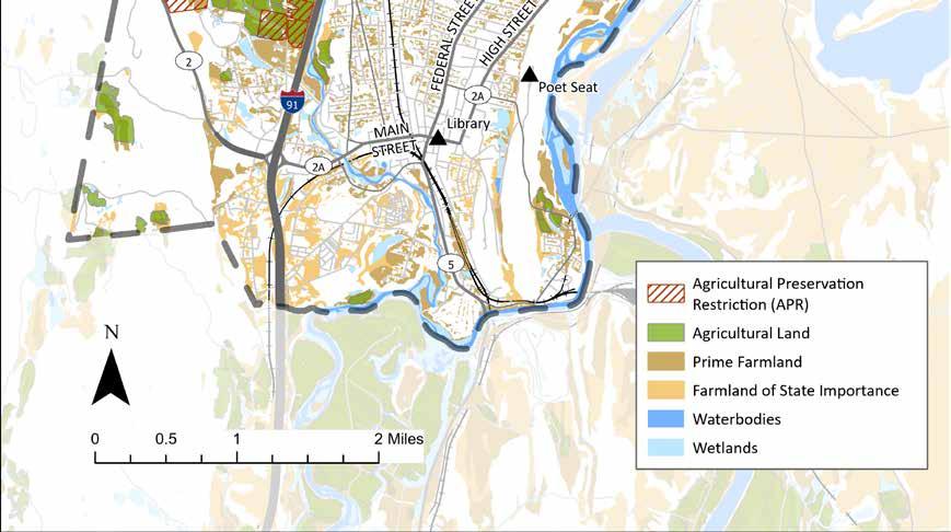

The story of pre-colonial Ct river valley. And the industrial era put into perspective, in that a bright incredible future can be envisioned for this community if we get creative about how to live here in appreciation of the land, awareness of its gifts and history (industry may not have been the "good old days" after all), and bold vision for how people can take part/take pride, be healthy and happy in this very special place. Finally, we need to move towards that "healthy" community by doing things like get rid of lead in the housing stock, generally engage in housing justice, and give voice/access to all ages, all incomes, all backgrounds, all genders. The “industrial heritage” has a glow around it that I think is overdue for reassessment. It’s good to understand history in its fullness, and we seem eager to celebrate the olden days of factories and mills without considering that people ran roughshod over the environment and that labor standards were often abysmal. New industry in town could be a boon, but only if they are properly regulated and labor is respected, preferably unionized.
Greenfield LU/NHC Update 66
Historic Resources and Tools for their Protection
The place now known as Greenfield has not always been defined by its current political borders. During the nineteenth century, it was part of the neighboring town of Deerfield. And before those colonial divisions, when boundaries were matters of social relationships rather than lines on maps, this land was traversed, cultivated, and hunted upon by a broad network of Algonquin peoples including the Pocumtuck.
The Pocumtuck and other Native peoples were driven from their homes in present-day Greenfield and Deerfield during the late seventeenth-century conflict that has come to be known as King Philip’s War. During this period, Native peoples throughout the northeast banded together in attempts to resist their displacement by the English, and many became refugees and exiles. According to Jennifer Lee, the Pocumtuck and other peoples of the Connecticut River Valley “ blended into the Abenaki, Nipmuck, and Mohican tribes” and “[w]hen danger passed, some came back to their homeland” (3).
The existence of Native Americans has been largely ignored for generations, yet Native peoples managed to survive in North America for thousands of years. In both of the community engagement events facilitated by the Conway team, participants expressed a desire to acknowledge and celebrate the long history of human settlement in the area now known as Greenfield:
I would encourage that this not just be thought about as history but as a contemporary issue. Indigenous people remain involved in the stewardship of this land. There’s an opportunity for communities and organizations to coalesce around providing long term support and funds to Tribal governments and Indigenous-led organizations. Starting with Indigenous Cultural Revitalization will lead to better social and ecological outcomes for us all.
Greenfield’s colonial history began with the arrival of European settlers in the late seventeenth century. After the American Revolution, Greenfield became a vital economic and cultural center in Franklin County, thriving in agriculture and industry due to its location. Cheapside, a port on the Connecticut River, was annexed from Deerfield in the 1890s. By the early nineteenth century, textile mills and sawmills on the Green River and Fall River spurred growth. Precision metalworking industries were later established, producing innovations like the first Bowie knife, cutlery and thread-cutting dies. The arrival of the north/south Connecticut River Railroad in 1846 bolstered Greenfield’s role as a transportation hub, leading to Cheapside’s decline.
Through the nineteenth and twentieth centuries, Greenfield grew into a vibrant center, with agriculture central to its identity, shifting from dairy and tobacco to a more diverse range of crops. The main agricultural area, the Meadows along the Green River, still showcases many eighteenth-century farmhouses and farms. Downtown Greenfield, particularly at Main and Federal Streets, reflects its history as the first Franklin County Courthouse location and county seat, with architectural styles ranging from Early Republic to Art Deco. Notable buildings include the Garden Theater Block (1928) and the Second Congregational Church (1868), present and former Town Halls, and the former Library designed by Asher Benjamin.
During the Early Industrial period, Greenfield experienced significant population growth, reaching 3,589 by 1870 and becoming the largest town in the county by 1895. In 1855, it had the highest foreign-born population in Franklin County, with a majority being Irish immigrants. The town’s population fluctuated due to industrial changes, booming during wartime and declining post-war. By 1940, Greenfield had a population of 15,672, making it the largest town in the county again, with a thriving downtown featuring a department store as well as clothing, stationery and other such stores. Throughout this period, immigrants, particularly Irish and German populations, played a significant role in shaping Greenfield’s demographic landscape (MHC, “MHC Reconnaissance Survey Town Report”).

Partner with Indigenous Tribes to identify ways land can be returned to Indigenous stewardship.

Indigenous History all over the city!
Greenfield LU/NHC Update 67
In Massachusetts, there are two main types of historic districts: National Register Districts and Local Historic Districts. The National Register of Historic Places is a federal listing that recognizes significant buildings and areas, providing formal recognition and potential tax incentives. Being on the National Register does not restrict an owner’s use of the property unless there is state or federal involvement. “Inventoried” means the property or area has been documented for historical significance, including architectural style, age, and historical use. This documentation is a step towards potential listing on historic registers like the National Register of Historic Places (National Park Service).
A Local Historic District is established at the local level and involves a regulatory review process for changes visible from public areas. It aims to preserve the historic character and architectural integrity of the area. Properties within a Local Historic District are subject to regulations on renovations, additions, and new construction to maintain the district’s historic character (MHC, “Establishing Local Historic Districts”).
Both National Register Districts and Local Historic Districts in Massachusetts are listed on the State Register of Historic Places. This listing allows properties owned by municipalities or non-profit organizations within these districts to qualify for grants from the Massachusetts Preservation Projects Fund when funding is available.
Twenty-six historic areas have been surveyed in Greenfield, resulting in approximately 500 individual properties being documented and inventoried. Five districts and around 594 individual properties have been listed on the National Register of Historic Places.
One notable district is the Main Street Historic District (GRE.A), featuring fifty-six properties, monuments, and structures along Main Street and Bank Row from Chapman Street to Franklin Street. This district encompasses elements of the city’s history and architecture as well as statues that commemorate local historical events.
There are also two nationally significant Asher Benjamin buildings included in the National Register: the LeavittHovey House (1797) and Coleman-Hollister House (1797). Asher Benjamin was an influential American architect and author in the late eighteenth and early nineteenth centuries. Born in Greenfield, Massachusetts, he brought attention to the Federal style of architecture in the United States.
The East Main/High Street Historic District (GRE.B) comprises fifty-eight significant properties situated in the eastern part of Main Street, the southern portion of High Street, and the residential neighborhoods of Church Street, Park Street, and Franklin Street. Reflecting a prosperous era in Greenfield’s history, the district is bordered by landmarks like the Weldon Hotel (1905) to the north, St. James Episcopal Church to the west, and numerous elegant residences along Main Street.
Furthermore, there are thirteen other designated areas with state-recognized properties outside downtown Greenfield, such as the Franklin County Fairgrounds. The Franklin County Fairgrounds represents the agricultural history of the city and is the site of one of the oldest continuously operating county fairs in the country.
For a complete list of properties in the State Register of Historic Places, refer to the Massachusetts Cultural Resource Information System. Various public and private entities actively participate in preserving Greenfield’s rich history (“Greenfield Reconnaissance Report”).
Recently, Greenfield was awarded a $20,000 matching grant by the Massachusetts Historical Commission to update its historic properties survey. The survey connects cultural resources to historic patterns of architecture, land use, economic development, social and demographic history, and impactful events.
This Survey and Planning Grant will support a $40,000 study, which involves reviewing documentation for over 550 properties already identified by the city, as well as assessing and documenting an additional 140 cultural and architectural resources. One example of the review is the update of the existing documentation for the Green River Industrial Heritage Area, encompassing River, Mill, and Deerfield streets. Additionally, the survey aims to recognize the community’s ethnic and cultural diversity, identifying resources tied to underrepresented minority groups’ history. This will include updating or adding inventory forms for African American history in Greenfield, acknowledging their contributions to the community’s history (Byrne).
Greenfield LU/NHC Update 68
Registered Historical Districts and Inventoried Historic Areas
Registered districts and inventoried areas alongside priority heritage landscapes including: Town Common, Franklin County Fairgrounds, Mohawk Trail, Rocky Mountain, and the Meadows.


Inventoried Historic Areas
National Register Historic District
Priority Heritage Landscape
Greenfield LU/NHC Update 69
Town Common
Franklin County Fairgrounds
Mohawk Trail
Rocky Mountain
The Meadows
Significant Historic Resources
According to Sustainable Greenfield, the Riverside Archaeological District was the site of Native American encampments as well as the location of a military encounter between colonial forces and Native Americans during King Philip’s War in 1676 (163). In addition to the Riverside Archaeological District, there are six historic-period and 25 prehistoric-period archaeological resources within the boundaries of the city (MACRIS Maps 2013).
Scenic Byways are special roadways that meet specific criteria set by the Federal Highway Administration (FHWA), considering natural, cultural, archaeological, historic, scenic, and recreational qualities. In Massachusetts, statedesignated scenic byways align with the National Scenic Byways Program, established by the Intermodal Surface Transportation Efficiency Act of 1991. This program provides grant opportunities to states for preserving existing resources (MassDOT 2013). So far, 915 acres of landscapes that are important to the Mohawk Trail, Connecticut River, and Route 112 Scenic Byways have been permanently preserved.
Greenfield is home to a portion of the Mohawk Trail, one of Franklin County’s five state-designated scenic byways (Scenic Byways – FRCOG). The Mohawk Trail, Route 2, is an east-west state highway in Massachusetts, cutting through Greenfield. This segment from Greenfield’s western border to Shelburne Road offers views of the town, highlighting the Meadows and Greenfield Community College. A Corridor Management Plan is currently in progress for the section between Greenfield and Athol. Franklin Regional Council of Governments is currently implementing several plan recommendations, including improvements to tourism and historic facilities (such as installing interpretive signs) and acquiring scenic easements (FRCOG, “Franklin County Bikeway Plan Update”).
Heritage landscapes are places shaped by human interaction with the environment, defining a community’s character and providing a sense of belonging. The Heritage Landscapes Inventory Program, sponsored by the Massachusetts Department of Conservation and Recreation (DCR), supports projects for inventorying, planning, constructing, preserving, maintaining landscapes, and educating the public about them (“Greenfield Reconnaissance Report”).
In January 2008, Greenfield collaborated with DCR to facilitate a heritage landscape identification meeting. During this session, residents and officials pinpointed and prioritized the natural and cultural landscapes that embody the town’s unique character. Thirty-three landscapes were identified, with five designated as Priority Heritage Landscapes: Town Common area, Franklin County Fairgrounds, Mohawk Trail, Rocky Mountain area, and the Meadows. These designations are illustrated on the map of Registered Historical Districts and Inventoried Historic Areas presented on the previous page.

Underground Railroad, Historical buildings would like to see signage at each especially downtown to make a walking tour of these.
Greenfield LU/NHC Update 70
Preservation Goals
The previous comprehensive plan’s recommendations for conserving historical resources included updating the city’s inventory of historic properties and sites, developing a Historic Preservation Plan, supporting the creative reuse of historic buildings, assisting in the acquisition of threatened Heritage Landscapes, and preserving historic artifacts and documents in an accessible format.
The Historical Commission and community members are interested in creating a local historic district in Greenfield, which would involve regulations for preserving the exteriors of significant buildings. Once established, Greenfield would qualify as a Certified Local Government (CLG). The Certified Local Government Program, described on the MHC website, provides a partnership for federal, state, and local preservation efforts. Communities with historic preservation legislation can apply for CLG certification, allowing them to directly participate in reviewing and approving National Register nominations. CLGs are also eligible for at least 10% of the federal funds allocated to MHC. This achievement would position Greenfield in a smaller, more favored group for preservation funding opportunities.
The Massachusetts Community Preservation Act (CPA) allows municipalities to add a property tax surcharge of up to 3%, which is then matched by state funds. This initiative aims to fund projects in community housing, historic preservation, open space conservation, and outdoor recreation. In 2020, Greenfield residents voted for a 1% local surcharge under the CPA. This means Greenfield property owners pay an extra 1% on their property tax bill, matched by state funds for community preservation projects (Community Preservation Committee).
Regulatory Tools
Current regulatory tools aimed at preserving its historic properties include the authority of the Greenfield Historical Commission, the Demolition Delay Ordinance, preservation restrictions, and adherence to federal and state regulations such as Section 106, Chapter 254, and MEPA. These measures are briefly outlined below.
The Greenfield Historical Commission, established in 1972, serves as the preservation planning arm of the city’s government. It identifies, preserves, and develops Greenfield’s historic assets in collaboration with the Historical Society of Greenfield, which maintains and communicates the town’s diverse history through archival collections, exhibitions, educational resources, and programs.
The Commission has three primary responsibilities:
• Participating in research, advocacy, survey, and public education programs to preserve the town’s historic and cultural assets.
• Hearing and deciding on cases of demolition according to the Demolition Delay Ordinance, Chapter 58 of the Town Code.
• Investigating the feasibility of establishing Local Historic Districts, proposing changes to district boundaries, reporting on historical and architectural significance, holding public hearings, and submitting final reports with recommendations to the Town Council (Town of Greenfield 2011).
The Demolition Delay Ordinance, outlined in Chapter 58 of the Town Code, was put in place by Greenfield to protect and preserve buildings that are historically important. This ordinance allows the public to provide input on applications for demolition permits for buildings deemed “significant” to Greenfield’s architectural, cultural, political, economic, or social history. A building is considered “significant” if it is listed or eligible for listing in the National Register of Historic Places (NRHP), in the State Register of Historic Places, or if recommended by the Historical Commission and approved by the Town Council. Despite being available, the Town has not yet used the Demolition Delay Ordinance.
Greenfield LU/NHC Update 71
Demolition Delay Ordinance
Greenfield Historical Commission
Preservation restrictions are legal contracts where property owners agree to preserve the historic and architectural integrity of their property. These agreements are customized for each building, protecting elements like the facade, interior, architectural details, or landscapes. In Greenfield, four properties in the State Register of Historic Places have preservation restrictions:
• First Franklin County Courthouse
• First National Bank and Trust of Greenfield
• Franklin County Fairgrounds Roundhouse Barn
• Leavitt-Hovey House (MHC 2013)
Section 106 of the National Historic Preservation Act requires projects with federal funding or permits to be reviewed for impacts on historic properties. If a property is eligible or listed in the National Register of Historic Places (NRHP), the project’s impact must be assessed and approved by the Massachusetts Historical Commission (MHC). The federal agency consults with the MHC for mitigation options if there is an adverse effect. This applies to projects like U.S. Army Corps of Engineers permits and Federal Highway Administration-supported road improvements.
• Chapter 254 of Massachusetts General Laws requires state-funded projects to be reviewed for impacts on properties listed in the State Register of Historic Places. If there is an adverse effect, the state agency and project proponent consult with the MHC for mitigation measures. This also applies to properties eligible for the NRHP in the Inventory of Historic and Archaeological Assets of the Commonwealth. It is relevant for town projects needing state permits or funding.
• MEPA, the Massachusetts Environmental Policy Act, mandates a review process for state-supported projects. It includes evaluating impacts on historic properties listed in the State Register of Historic Places or the Inventory of Historic and Archaeological Assets of the Commonwealth since 1998. MEPA requires developing feasible mitigation options for environmental impacts, including those on historic properties.
Preservation restrictions
Federal and State Regulations

Greenfield LU/NHC Update 72
Cultural Resources
Greenfield hosts a diverse range of artists, including painters, sculptors, musicians, and performers who showcase their work in various galleries, live music venues, and performance spaces such as Hawks & Reed Performing Arts Center, 10 Forward, the Energy Park, Greenfield Gallery, and The Local Access to Valley Arts ( LAVA Center). These venues offer platforms for local, regional, and national artists to share their talents and creative endeavors.
The city also places a strong emphasis on sustainability and environmental awareness. Initiatives like the community garden at the John Zon Community Center and farmers’ markets at Court Square demonstrate Greenfield’s commitment to green living. This focus extends to the preservation of green spaces and outdoor recreation areas like Energy Park, which provides opportunities for residents and visitors to connect and participate in community events.
Greenfield’s historical heritage is evident in landmarks such as Poet’s Seat Tower, reflecting the city’s past and evolution over time. Museums, historic buildings, and archaeological districts offer insights into Greenfield’s history and cultural significance. The Pocumtuck indigenous peoples play a significant role in the cultural and historical landscape of the area through oral tradition, passing down stories, legends, and cultural practices through generations. Many Greenfield residents have voiced their desire to do more to acknowledge and respect historical and living Indigenous peoples.
Public events such as the Franklin County Fair, Green River Festival, and the Bee Fest are important elements of Greenfield’s culture, bringing residents together to celebrate local traditions. The city’s support for local businesses, including numerous locally-owned shops, eateries, breweries, and galleries, contributes to a strong sense of community.
Overall, Greenfield’s culture is characterized by its diverse artistic community, commitment to sustainability, rich historical heritage, and strong sense of community spirit.


Overview
Greenfield’s downtown features bee sculptures, while murals and crosswalks by community members adorn Veterans Mall, Court Square, Wilson’s and Green Fields Market. Utility boxes and parking meters also display artistic touches, adding character to the town. Greenfield embraces the arts and music scene, fostering a unique culture of craftsmanship and entertainment. Some of the town’s cultural institutions include:
Crossroads Cultural District
Greenfield's Crossroads Cultural District, designated in 2016, is nestled at the junction of Route 2 and Interstate 91, with the Mohawk Trail (2A) and scenic Routes 5 & 10 running through it. This district, a product of the Mass Cultural Council's initiative launched in 2011, aids in supporting economic growth, enhancing local character, and enriching the lives of visitors and residents alike. Originally a crossroads for eighteenth and nineteenth century travelers on routes like the Boston-Albany and Montreal-New York trains, today Greenfield's Cultural District is visited by cross-country skiers, cyclists, and leaf-peepers, offering a diverse array of cultural experiences for both residents and visitors.
Greenfield LU/NHC Update 73
The Greenfield Local Cultural Council (GLCC), an official city committee composed of volunteers, prioritizes funding for artistic projects held in Greenfield that are open to the public. The GLCC is dedicated to supporting local artists, performers, and venues that enrich the cultural life of the community. This council supports heritage and natural history, performing and visual arts, as well as participatory other events and activities in Greenfield. As a member of the Massachusetts Cultural Council’s Local Cultural Council program, the council is a part of the nation’s largest grassroots cultural funding network. This program supports thousands of community-based projects in the arts, humanities, and sciences each year. Statewide, local councils like Greenfield’s award over $2 million in grants to more than 5,000 cultural programs annually. The Greenfield Local Cultural Council was recently granted $19,400 for FY2024 to fund 59 projects.
Situated on Mead Street along the Green River, is dedicated to celebrating industrial heritage, with a particular focus on Franklin County and Athol, Massachusetts. Its mission, as stated on the museum’s website, is to “celebrate industrial heritage through preserving, collecting, and educating the public.” The museum highlights technology, transportation, and trade in and around Greenfield, emphasizing its own neighborhood to tell a broader national story (CPC). The organization offers on-site exhibits that display artifacts from the area’s factories and mills. It also provides walking tours of the Green River, the site of waterpowered mills that helped spur local industrial activity. In 2020, the Museum acquired a Wiley & Russell bolt threading machine from a small blacksmith shop in New Hampshire.
The park stands proudly in downtown Greenfield. This park offers a blend of attractions, including a caboose museum, native plants and gardens, interpretive signage, solar panels, and a performance stage. Throughout the summer, the Recreation Department organizes concerts featuring a mix of local and national musicians such as Catie Curtis, Lucy Kaplansky, Rani Arbo & Daisy Mayhem, Lori McKenna, Jay Ungar & Molly Mason, the Franklin County Musicians CoOp, and the Greenfield Military Band. Spanning one and one-quarter acres, the park’s mission is to serve as an inviting gathering place for lunches, concerts, workshops, and public education on sustainable energy issues in a friendly, approachable atmosphere. Funding for this community gem came from grants, foundation gifts, and individual contributions. Owned by the City of Greenfield, the Energy Park is a collaborative effort with NESEA, a not-for-profit organization. NESEA continuously organizes clean energy exhibits and programs at the park, fostering community engagement and providing opportunities for visitors to learn more about renewable energy firsthand.

What from Greenfield’s past would you like to see preserved?
I love the way the town comes together around events that support town history, like the Winter Carnival, and the Bee thing that happens in summer (I forget the name).
Greenfielders take great pride in the area’s innovations and traditions, and I think that’s really special and draws community together.
Greenfield LU/NHC Update 74
Greenfield Local Cultural Council
The Museum of Our Industrial Heritage
Energy Park
energy park concert
M. Chicoine, 2019
The triathlon is held annually and recognized as the longest-running triathlon in New England. The race takes participants through the scenic back roads of Greenfield, passing landmarks such as the Historic Eunice Williams Covered Bridge, and includes a swim portion in the Green River. Participants in the Greenfield Triathlon can choose between International and Sprint distances for individual athletes, as well as options for two- and three-person teams. This makes the event suitable for both beginners and seasoned triathletes. All race proceeds go to benefit the Greenfield Recreation Department, helping to fund programs and events for families in the Greenfield community. This blend of competition and community support has made the Greenfield Triathlon a significant tradition in the area.
The parade is a cherished tradition in Greenfield, where both adults and children dress in Halloween costumes to enjoy trick-or-treating at local businesses. Coordinated by the Recreation Department and Greenfield Business Association, with support from various organizations, highlights include a Rag Shag Parade, Costume Contest, giant pumpkin carving, and a free movie at the Garden Cinema. This annual event brings together the community for a fun and festive celebration of Halloween, providing a safe and enjoyable experience for all ages.
Bee Fest launched in 2010 by the Second Congregational Church, to celebrate bees and pollinators inspired by Reverend Lorenzo L. Langstroth, “Father of Modern Beekeeping.” The festival features games, crafts, lectures, music, and a costume parade, all emphasizing the role of bees in our food supply and environment. Attendees learn about creating pollinator-friendly habitats, reducing pesticides, and receive free seeds and seedlings.
A regional theater company founded in 2010, aims to produce thoughtful, engaging, and artistic theater for the Pioneer Valley community and beyond. They focus on presenting a wide range of theatrical works, from classic plays to contemporary pieces, often with a social or political message. Silverthorne Theater Company has performed at various venues in the past, including the Hawks & Reed Performing Arts Center mentioned previously. The company offers educational programs, workshops, and outreach activities to engage with the community. Now located downtown.
The Green River Festival had its beginnings as two separate events held a week apart in 1986 at Greenfield Community College. Initially, the Franklin County Chamber Of Commerce sponsored the Upcountry Balloon Fair on one weekend, followed by a fifth anniversary celebration of local radio station WRSI on the next, featuring various artists. These two events eventually merged to form what is now known as the Green River Festival. Initially centered around hot air ballooning, the festival began to evolve in 1990 with a performance by New Orleans music legend Dr. John and an expanded lineup of nationally renowned acts. Throughout the 1990s, the festival showcased emerging and established talent in the roots music genre, including artists like Alison Krauss & Union Station, Taj Mahal, Gillian Welch & David Rawlings, among others.
By 2001, the festival rebranded as The Green River Festival, broadening its musical offerings to include more artists and multiple stages. Since then, the festival has hosted a diverse array of music icons, from artists like Emmylou Harris, Buddy Guy, and Lucinda Williams, to The Avett Brothers, Deer Tick, Neko Case, and many others.
Greenfield Historical Society The Historical Society of Greenfield, Massachusetts, operates as a nonprofit organization dedicated to preserving and sharing the rich history of Greenfield. Through the promotion of archival collections, cultural exhibitions, educational materials, and diverse programs, it aims to engage local residents, the broader community, and learners of all ages in exploring the heritage of the region.
Greenfield LU/NHC Update 75
Greenfield Triathlon
The Halloween Downtown Trick-orTreat and Rag Shag Parade
Bee Fest
Silverthorne Theater Company
Green River Festival
The Wormtown Music Festival is an annual event held at Camp Kee-wanee, an arts-focused summer day camp. This festival spans three days of music and includes two nights of camping in the woods, along with various other activities (Wormtown Trading Co. 2013a). Sponsored by Wormtown Trading, the festival is part of their yearly lineup, which also includes the StrangeCreek Campout, another event held at Camp Kee-wanee featuring musical entertainment and wooded camping (Wormtown Trading Co. 2013b).
Established in 1973, Artspace is Franklin County’s creative hub located near downtown. Artspace’s mission is to provide accessible arts and music education to the community. It offers a wide range of services, including art shows, music lessons, free community events, and more. One of its initiatives is the Strings For Kids program, developed in partnership with Greenfield public schools, offering all young students the chance to learn and play a stringed instrument. Operating as a 501(c)(3) nonprofit organization, it does its best to ensure financial accessibility for students by providing grants through community-supported fundraising. Additionally, Artspace runs an outreach program advocating for the arts in the community. Recently, Artspace was awarded the 2023 Massachusetts Cultural Council’s Cultural Facilities Fund grant, which will support the planning of an inclusive and affordable community ceramics studio and program.
The Pioneer Valley Symphony Orchestra (PVS), established in 1939, is one of the oldest community orchestras in the US. With over 200 volunteer musicians, PVS presents six symphonic concerts each year, offering diverse programs including family-oriented and educational shows. While most performances are in Greenfield, concerts also happen in Northampton and Amherst. Recently, PVS expanded its offerings to manage Strings for Kids (in partnership with Greenfield Public Schools), private lessons, and group music instruction. These additions complement existing educational programs like the Youth Orchestra (since 2013) and Education Concert (since 1994). These new programs were previously run by Artspace Community Arts Center of Greenfield. In January 2023, Artspace sought a new steward for their music school, and PVS stepped in. The organization now operates activities at Artspace and various Greenfield locations, supporting the local music scene and ensuring accessible music education for the community.

Greenfield LU/NHC Update 76
Wormtown Music Festival
Artspace
Pioneer Valley Symphony Orchestra
street art on Recorder building
City of Greenfield
In 2017, the Arts Block building was renamed the Hawks & Reed Performing Arts Center. The center presents music and the arts in an accessible, compelling, and hospitable manner, benefiting the social and economic well-being of the community. This multi-venue arts and entertainment space serves as a hub for various performances, including music concerts, theatrical productions, comedy shows, and more. For the latest updates on upcoming events and performances, it’s recommended to check the center’s official website or social media pages, as details may change regularly.
The Greenfield Winter Carnival, a tradition dating back to 1922 and organized by the Greenfield Recreation Department, takes place on the first weekend in February. This three-day celebration offers a host of indoor and outdoor activities. Events like the Sleigh Bell Run, Breakfast with Frosty, K9 Keg Pull, chili cook-off, and Cardboard Sled Race are just some of the activities hosted by the festival. This annual community event brings together residents to celebrate the winter season with live music, parades, outdoor games, and delicious food vendors, creating a fun-filled weekend for all.
The LAVA Center, opened in early 2020 downtown, serves as a community arts space, arts incubator, and black box theater. Its mission is to provide a platform for all voices, particularly those of marginalized communities, to be heard and celebrated. The Center offers various opportunities for creatives to develop and showcase their work. The center’s programming focuses on local history, social justice, and environmental themes.
The HIVE is a community workshop (storefront downtown) dedicated to empowering individuals through access to tools and collective action. The mission is to foster community resilience, skill-sharing, collaborative learning, and creativity. At The Hive, members have access to a range of prototyping and production equipment, including 3D printers, a 3D scanner, design workstations, a 3-axis CNC mill, manual 3-axis mills, a metal lathe, soldering stations, industrial sewing machines, and an array of hand and power tools.

Greenfield LU/NHC Update 77
LAVA Center
HIVE
Hawks & Reeds Performing Arts Center
Greenfield Winter Carnival
City of Greenfield

LU/NHC Update 78
Greenfield
Downtown Fiske Ave pocket park utility box art
Mary Chicoine, 2022
Conclusion
Greenfield’s Natural, Historic, and Cultural resources are fundamental to its identity as a community. These elements aren’t just assets; they’re the organs of Greenfield and Franklin County. The residents of Greenfield are clear in their desire to steward and preserve the land and its heritage.
By embracing initiatives led by local groups such as Greening Greenfield and the Nolumbeka Project, the community is strengthening its connection to the land and its stories. As Greenfield faces challenges like climate change and globalization, the value of protecting these resources is acutely felt.
Greenfield’s water resources in particular are central to the community’s identity and culture. Beyond their recreational and ecological value, these rivers, streams, ponds, and wetlands shape Greenfield’s character. Residents are dedicated to conserving these resources, reflecting the town’s commitment to sustainability in a deep sense.
Beyond preserving the best of its past, Greenfield is motivated to create a future where its natural, historic, and cultural assets can flourish. Through collective effort and dedication, Greenfield will continue to build a resilient and vibrant community for generations to come. The following section offers a necessarily incomplete list of recommendations that may aid in this effort.
Greenfield LU/NHC Update 79
Recommendations
The following list of recommendations is based on research, spatial analyses, two community engagement events, and discussions with Greenfield residents. It includes items from previous planning documents that are yet-to-be completed or are ongoing as well as new items. Recommendations that are carried over from previous planning documents are indicated with a plus sign (+). The list is organized into Goals, Strategies, and Action Items. Goals describe general aspirations or desired states, Strategies specify focus areas within Goals, and Action Items name specific steps that may contribute to the realization of Strategies or Goals.
The City of Greenfield is the implied subject of most but not all of the items on this list. Some of the items are ideas that city officials may choose to act on during the ordinary course of their duties. Others are policy suggestions that would need to be formally proposed and voted on. Some of them are projects that may only be achievable should a particular source of funding (CPA, MassDOT, MVP, etc.) become available; others pertain to projects the city may already have planned. Still others urge communication and coordination between the city and residents or groups of residents to achieve specific results.
Goal Strategy Action Item
+ Existing Goal, Strategy, or Action Item
Land Use
Downtown
Cultivate a lively, attractive, and accessible downtown environment.
Promote development and redevelopment in the downtown area to encourage a livelier downtown and help curb the loss of open space.
+ Investigate whether an infill development ordinance and/or adaptive reuse overlay district could make it easier to redevelop vacant and underused spaces in non-conforming lots.
Provide inspirational public education on planned development using form-based codes or other mechanisms to help Greenfield residents envision the full spectrum of possibilities for their community.
Increase the functionality of existing community gathering spaces and create new gathering spaces where possible.
+ Work with DPW and Main Street property owners to ensure good snow and ice removal for safe and universal access to sidewalks, parking meters and stores.
Work with area businesses to revisit configurations of Court Square that encourage events and gathering.
+ Encourage more outdoor dining spaces and food trucks.
+ Encourage cooperation between the town and businesses to transform underutilized areas such as alleys, rear entrances, and parking lots into welcoming environments (courts, patios, plazas) for everyone.
Clean up, repair, and beautify vacant storefronts.
Provide more funding from the Community Development Block Grant program (CDBG) or the Regional Economic Development Organizations (REDO) grant to the Facade Improvement Program to aid building owners in making facade improvements.
Greenfield LU/NHC Update 80
Work with the Local and/or Crossroads Cultural Councils to award funds to artists for storefront improvements for willing property and/or business owners.
Invite volunteers to help with downtown maintenance.
Seek funding to hire a volunteer coordinator for downtown cleanup and garden and greenspace maintenance.
Organize a volunteer group that would help to clean up downtown.
Work with existing groups that maintain gardens and green spaces to support and expand their efforts.
Attract new businesses and support existing businesses.
Strengthen the partnership between the city’s Community and Economic Development Department and the Greenfield Business Association to attract and retain businesses on Main Street and elsewhere.
Widely promote visitgreenfieldma.com to potential business owners and work to ensure existing businesses are included on the website.
+ Streamline permits, licensing, and zoning processes for creative enterprises.
Improve and expand pedestrian and bicycle access, and public transportation, downtown.
Improve bicycle safety to encourage the use of bikes to access downtown.
Explore whether Deerfield would be interested in collaborating on a safe bike trail between Greenfield and Deerfield along Route 5/10.
Increase bicycle racks and other infrastructure in downtown.
Seek creative solutions to build a safe pedestrian and bicycle path along or near Turners Falls Road to increase non-motorized travel to and from Turners Falls.
Housing
Increase housing stock and accessibility of housing units.
Revise zoning ordinances to allow greater density of housing downtown and in the greater downtown area.
Allow multifamily dwellings by right (with site plan review) in Semi-Residential zone.
Raise the maximum number of units allowed in new multifamily dwellings.
Amend zoning ordinance 200-7.10 to allow first-floor dwellings in mixed use lots.
Look for ways to encourage single- to two- or three-family conversions.
Revise dimensional regulations to allow row houses in the Central Commercial, General Commercial, Semi-Residential, and Urban Residential zones.
Consider allowing detached accessory dwelling units by right in all zones.
Revise open space development ordinance to provide density bonuses for affordable housing and/or increased protection of open space and to reduce lot size minimums.
Address the dire need for barrier-free housing.
Advocate for a state or local program to incentivize rental property owners to retrofit existing properties with accessible features such as step-free entry, grab bars, ramps and other barrier-free features.
Increase public awareness about the need for barrier-free housing.
Continue to work with Housing Greenfield and other organizations to proactively address the need for housing.
Increase resources and programs to support the houseless population.
Greenfield LU/NHC Update 81
Citywide
Promote the growth of industry in Greenfield.
Develop additional properties that will accommodate industrial uses within areas currently zoned for these uses.
Ensure public health assessments are conducted prior to approving siting of industrial uses, particularly in properties that are in or adjacent to residential neighborhoods.
Work with the Franklin County Community Development Corporation and area farmers to determine which types of industry would complement or help to grow the food processing ecosystem in Greenfield.
Ensure that Greenfield’s water infrastructure meets residents’ existing needs, allows for the possibility of development, and can handle climate change-related stresses such as flooding in ways that are environmentally sound.
Continue to repair and renovate the city’s sanitary sewer system to ensure reliable service for residents and prevent overflows during heavy rain events.
Continue to pursue and maximize benefits from state and federal grant opportunities to fund sanitary sewer maintenance.
Ensure that rates charged for municipal sewer services keep pace with the need for repairs and maintenance.
Require that new residential sump pumps be inspected and registered to reduce illicit connections.
+ Incorporate Green Infrastructure and Low Impact Design (LID) strategies into all municipal projects.
Conduct an analysis of impervious surfaces, slopes, and stormwater drains to determine where the heaviest flows of stormwater enter storm drains, streams, and rivers and where rain gardens or rain garden-integrated storm drains could most effectively intercept and infiltrate rainfall.
Require that proposals for all major projects include a quote for green infrastructure aimed at slowing, retaining and promoting infiltration of stormwater. Explore different avenues for financial assistance for implementation. If green infrastructure is determined to not be feasible due to cost, an explanation of cost and funding options explored should be presented to SGIC.
+ Upgrade all municipal parking lots using Low Impact Development principles, with consideration of the 2012 Conway School study as a model.
Train DPW staff on green infrastructure installation and maintenance.
Conduct a study of the Maple Brook Culvert system with plans for phased implementation of green infrastructure within its catchment area to reduce flooding and improve the health of adjacent water bodies. Areas that could be addressed in such a study include the mouth of the culvert at Miller’s Meadow, any easements or city-owned land between Chapman Street and Davis Street, 34 Riddell Street, and opportunities to capture stormwater upstream. The study should also describe the maintenance needs of any proposed interventions.
Apply for MVP and other funding to include green infrastructure in stormwater system upgrades.
Encourage developers and landlords to employ best practices for stormwater management.
+ Remove or reduce parking requirements, or implement parking maximums, to reduce impermeable surfaces outside of downtown.
Establish LID ordinances for commercial, industrial, and redevelopment projects.
Educate residents about the stormwater system in Greenfield and what they can do to help take care of it.
Greenfield LU/NHC Update 82
Create a demonstration site on municipal or partner property with examples of green infrastructure such as rain gardens, permeable pavement, bioswales, etc.
Use existing toolkits for rain gardens and other residential-scale green infrastructure to build awareness of residential options.
+ Provide incentives to homeowners to reduce the area of hardscapes and lawns and increase areas of productive landscapes such as food gardens, rain gardens and gardens for biodiversity.
Establish conservation corridors to maintain biodiversity and ecosystem services.
Identify and protect existing wildlife corridors.
Work with land trusts, conservation organizations, and other groups to acquire or otherwise protect parcels along the Green River and Mill Brook as well as along ridgelines in the west and on the Pocumtuck Ridge/Rocky Mountain.
Develop conservation overlay districts for critical terrestrial habitats.
Adopt a River Corridor Protection Zoning Overlay District based on the map delineated for The Green River Corridor Mapping and Management Report and the accompanying model legislation.
Increase the town’s solar energy production, especially on roofs and parking lots.
Minimize the impact of new solar development on forests and farmland.
Conduct a weighted analysis to identify desirable sites for ground-based solar. Prioritize impermeable surfaces, grayfields and other human-disturbed sites, and avoid essential wildlife habitat or prime farmland. Analysis factors could include: aspect, BioMap, NHESP, prime soils, land cover, and interconnection sites. Look for opportunities to install PV with meadows planted underneath.
Increase solar production on city-owned properties.
Work with the Department of Energy and Sustainability to install PV on municipal buildings that have already been identified as being PV-ready.
Install panels over city-owned parking lots.
Make good use of, and support, programs to promote solar installation by municipalities, businesses, and individuals.
Stay abreast of, and participate in, statewide programs to promote solar.
Advocate for the Massachusetts Department of Public Utilities (DPU) to support communityowned solar projects.
+ Support local solar installers to increase residential, business, and municipal investment in solar.
Natural, Historic, and Cultural Resources
For a complete list of recreation-related recommendations, see the Open Space and Recreation Plan.
Natural Resources
+ Establish a standing open space committee for the purpose of prioritizing and guiding land protection and implementing Greenfield’s Open Space and Recreation Plan (OSRP).
Increase urban tree canopy and expand urban green space.
Increase the city’s ability to plant and care for trees, and make tree-planting a regular part of city operations.
Greenfield LU/NHC Update 83
Increase municipal funding for DPW to conduct more tree planting and maintenance.
Increase the staffing and capacity of DPW’s Forestry Division to provide season-long watering of new trees and preventative tree maintenance to avoid more costly tree maintenance or removal in the future.
Update practices and procedures for sidewalk and street construction and/or replacement to include street trees as a standard component.
Include funding for tree planting in grant applications for sidewalk and street projects.
Coordinate tree-planting efforts by the city and volunteer groups in ways that are strategic and sustainable.
Plant primarily native trees throughout the city, following the List of Approved Trees (Greenfield Code Chapter 400, Appendix C) for Town Street Planting.
Review the List of Approved Trees and make changes as needed. Continue to update the list to accommodate the warming climate.
Prioritize tree-planting in spaces where trees are likely to flourish rather than where they may fail to thrive.
Minimize the planting of small-stature trees in sites where a shade tree can be accommodated.
Publicize and educate the public about the benefits of street trees and involve them in caring for trees and green spaces.
Acquire or otherwise conserve land deemed to be of critical importance to wildlife and/ or ecosystem services.
Identify parcels of critical importance.
+ Develop a prioritized inventory of natural resources in Greenfield, including open space, wildlife habitat, view corridors, heritage landscape, water resources, and agricultural land. Use the inventory to prioritize the preservation of these resources in all decision-making processes.
Create a Biodiversity Conservation Plan that identifies existing natural habitats and communities in Greenfield and prioritizes conservation and restoration areas.
Develop the city’s ability to conserve parcels of critical importance when opportunities arise.
Set goals for land acquisition and/or protection efforts while encouraging private land stewardship and protection.
Focus resources and efforts on the prioritized inventory and/or most threatened/critical areas.
Strategize about how CPA funds may be used to acquire and/or conserve high-priority parcels in partnership with other organizations.
Ensure that residents can access the town’s parks, rivers and waterbodies for recreation.
Increase community members’ access to the Green River and Fall River.
+ Identify waterfront areas along the Green River to prioritize for acquisition and/or protection.
Explore more low-maintenance site-design options to address frequent and damaging flooding of the Green River Swimming and Recreation Area.
Ensure just and equitable access to green spaces.
Assess whether residents in Environmental Justice areas are within walking distances of parks and/or green spaces.
Prioritize any development or improvement of parks, green spaces or recreational facilities within Environmental Justice neighborhoods, incorporating universal access throughout.
Greenfield LU/NHC Update 84
Conserve and restore Greenfield’s rivers, wetlands, and other water bodies.
Restore native vegetation around rivers and connectivity of river habitats where possible. Remove, partially remove, or repair the Wiley-Russell dam to prevent an uncontrolled dam failure and begin restoring connectivity in the Green River. Explore ways of memorializing the neighborhood’s industrial heritage beyond or apart from the dam.
Assess and prioritize riverbank sites on municipal land for invasive removal and native species restoration.
Conduct invasive plant species removal and native species restoration, coordinating with existing efforts.
Look for opportunities to plant or expand vegetated buffer strips around rivers and other water bodies on municipal lands. Set a goal of 100 foot buffers.
Continue to protect wetlands and educate people about their importance.
Ensure that the city’s inventory of vernal pools is up-to-date.
Install educational signs about wetlands and vernal pools near certified vernal pools. Potential locations include between Sunrise Avenue and the Connecticut River, the southwest corner of the Shelbourne Conservation Area, and Bear Den Road.
Update and revise Chapter 423, the city’s Wetland Protection Ordinance, with language that advocates for the planting and care of recommended beneficial plants in jurisdictional areas; or, consider a broader ordinance that permits and encourages citizen stewardship of public lands.
Develop a plan for ecological restoration of Highland Pond.
Ascertain the pond’s current and potential ecosystem function including the feasibility of dam removal.
Protect Greenfield’s drinking water supply.
Work with Planning Boards and Boards of Health to manage new residential developments in the water supply protection areas and to inform the boards of the resource areas.
Promote BMPs for stormwater management and pollution control in water supply protection areas.
Conserve Greenfield’s agricultural lands, support its farming community, and develop its status as a “food hub.”
+ Continue to work with landowners to conserve prime farmland and working farms.
Work with area land trusts when farmland is put up for sale to assess opportunities for permanent protection from development.
+ Pursue preservation options that include affordable “whole farm” preservation, including buildings.
+ Match owners of idle farmland, or those trying to identify a successor, with new or existing farmers looking for land.
Ensure a robust local support-system for farmers that includes multiple venues for conversations about financial stability and sustainability, retirement/succession plans, and programs that support agriculture such as Chapter 61 and APR.
Ensure the agriculture commission is focused on supporting farms and food processing businesses in Greenfield.
Help protect farmland by working with organizations such as American Farmland Trust, Land for Good, and the Community Conservation Program at Mount Grace Land Conservation Trust (MGLCT) to provide support to farmers on topics such as farm succession planning.
Install signs stating that Greenfield is a right-to-farm community.
Consider an agricultural overlay district that would permit certain accessory on-farm businesses by right.
Greenfield LU/NHC Update 85
Support food processing and distribution industries within Greenfield.
Promote the Franklin County Community Development Corporation’s Venture Center to attract more food businesses to the area.
Encourage the Greenfield’s Community and Economic Development Department to work on increasing the city’s capacity as a food processing hub.
+ Work with GCC to train individuals for employment in areas of food production, distribution, and processing.
+ Work with neighborhood groups to identify town-owned land that could be used for additional community food and flower gardens.
Cultural and Historical Resources
Acknowledge and celebrate the long history of human settlement in the place currently known as Greenfield.
Identify opportunities to acknowledge indigenous history in the landscape and in town programming.
+ Partner with Native American tribes to preserve strategic Native American sites. Develop informative signage and other ways of making native history visible.
Work with Native American tribes to develop programs or projects that showcase present day Native cultural practices and educate the general public on present day Native peoples.
Continue to look for ways to celebrate the city’s role in the Underground Railroad.
+ Continue to prioritize public arts programs to foster lively and attractive streetscapes through public/private partnerships.
+ Develop and implement a plan for historic preservation that includes creative reuse of historic buildings, the creation of local historic districts, and the nomination of additional National Register historic districts and individual properties.
+ Complete and publish an inventory of natural, historic, and cultural areas, and make information readily available to the public.
+ Institute residential and commercial historic plaque program.
+ Revitalize the Historic Commission with better marketing materials both online and in print, and develop an independent website including digital historic building inventory to increase citizens’ knowledge and interest.
Greenfield LU/NHC Update 86
Map Data
Introduction
REGIONAL CONTEXT
Esri: US State Boundaries
MassGIS: Massachusetts Municipalities
USGS: National Hydrography Dataset
Land Use
LAND COVER
MassGIS: Massachusetts Municipalities, Land Cover/Land Use (2016)
LAND USE
MassGIS: Massachusetts Municipalities, Land Cover/Land Use (2016), MassGIS-MassDOT Roads
TREE CANOPY
MassGIS: Building Structures (2-D), MassDEP Hydrography (1:25,000), MassDEP Wetlands
MRLC: NLCD 2021 USFS Tree Canopy Cover (CONUS)
NOAA: CCAP Impervious (2021)
TREE CANOPY AND ENVIRONMENTAL JUSTICE AREAS
MassGIS: Building Structures (2-D), MassDEP Hydrography (1:25,000), 2020 Environmental Justice Populations (2022), MassDEP Wetlands
MRLC: NLCD 2021 USFS Tree Canopy Cover (CONUS)
NOAA: CCAP Impervious (2021)
STORMWATER INFRASTRUCTURE AND WATER QUALITY
City of Greenfield: Drains, Drain Outfalls, FEMA 100-year Floodplain
MassGIS: Massachusetts Municipalities, MassGIS-MassDOT Roads, MassDEP Hydrography (1:25,000), MassDEP 2022 Integrated List of Waters (305(b)/303(d))
Natural, Historic, and Cultural Resources
GEOLOGY, AQUIFERS, AND SOILS
MassGIS: Massachusetts Municipalities, MassDEP Hydrography (1:25,000), Elevation Contours (1:250,000), MassGIS-MassDOT Roads, Surficial Geology (1:250,000), Aquifers, Public Water Supplies, Soils SSURGO-Certified NRCS, MassDEP Wetlands
PRIME SOILS/AGRICULTURAL USE/APR
MassGIS: Soils SSURGO-Certified NRCS, Land Cover/Land Use (2016), MassDEP Hydrography (1:25000), MassDEP Wetlands, Protected and Recreational OpenSpace (2024)
OPEN SPACE
MassGIS: Protected and Recreational OpenSpace (2024)
BIOMAP/PROTECTED LAND
MassGIS: BioMap: The Future of Conservation (2022), MassDEP Hydrography (1:25000), MassDEP Wetlands, Protected and Recreational OpenSpace (2024)
Greenfield LU/NHC Update 87
Works Cited
Berry, Wendell. “A Forest Conversation.” Our Only World. Counterpoint, 2015, 21-52.
Bhat, Tanisha. “Greenfield seniors ‘woefully in need’ of accessible, affordable housing.” The Recorder, 22 March 2024, https://www.recorder.com/Greenfield-seniors-woefully-in-need-of-accessible-affordablehousing-54471230.
Britannica. “Patch Dynamics.” https://www.britannica.com/science/patch-dynamics.
Bruchac, Marge. “The Geology and Cultural History of the Beaver Hill Story.” Pocumtuck Valley Memorial Association (PVMA), http://1704.deerfield.history.museum/voices/transcripts/wob_creation_essay.html.
Byrne, Mary. “$20K matching grant will help update Greenfield historic properties survey.” The Recorder, 3 March 2022, https://www.recorder.com/$20K-matching-grant-will-help-update-Greenfield-historic-propertiessurvey-50595389.
Catanzaro, Paul, and Anthony D’Amato. Forest Carbon: An essential natural solution for climate change. The University of Massachusetts at Amherst, 2019, http://masswoods.org/caring-your-land/forest-carbon.
Chicoine, Mary. Greenfield Tree Committee 2020 Greenfield Tree Inventory Report and Action Plan. Greenfield Tree Committee, 2020, https://6dff8875-db8b-4c79-96a1-d3e91a8f1b76.filesusr.com/ugd/6710bd_ e365be327a9f40f0a99506d37a6d573b.pdf.
City of Greenfield. “Greenfield Spotlights Energy Progress And Goals In Net-Zero Operations Plan.” https:// greenfield-ma.gov/news_detail_T4_R138.php.
——. MVP Resiliency Plan. Facilitated by the Franklin Regional Council of Governments, June 2021, https:// greenfield-ma.gov/Document_Center/Department/Planning%20&%20Development/MunicipalVulnerability-Preparedness-Plan-Report-to-EEA-2021.pdf.
City of Greenfield, Department of Housing and Community Development, and Stantec. Downtown Greenfield Parking Study. 2023.
Crimmins, A.R., C.W. Avery, D.R. Easterling, K.E. Kunkel, B.C. Stewart, and T.K. Maycock, Eds. USGCRP, 2023: Fifth National Climate Assessment. U.S. Global Change Research Program, Washington, DC, USA, https://doi. org/10.7930/NCA5.2023.
Environmental Protection Agency. “Climate Change Impacts on Forests.” https://www.epa.gov/climateimpacts/ climate-change-impacts-forests.
——. “Soak Up the Rain.” https://www.epa.gov/soakuptherain/soak-rain-permeable-pavement.
——. “Using Green Roofs to Reduce Heat Islands.” https://www.epa.gov/heatislands/using-green-roofs-reduceheat-islands.
——. “Environmental Justice?”https://www.epa.gov/brownfields/environmental-justice
——. “What is Green Infrastructure?” https://www.epa.gov/green-infrastructure/what-green-infrastructure.
Fox, Coleen A., Francis J. Magilligan, and Christopher S. Sneddon. “‘You kill the dam, you are killing a part of me’: Dam removal and the environmental politics of river restoration.” Geoforum 70, Mar. 2016, 93-104, https://www.sciencedirect.com/science/article/pii/S0016718516300720. Elsevier ScienceDirect.
Franklin Regional Council of Governments. Franklin County Bikeway Plan Update. 2009.
——. Planned Industrial Park Inventory Update for Franklin County, MA. February 2018.
——. “Redefining Our River Corridors.” https://frcog.org/redefining-our-river-corridors/.
Gildea, James. “History of the Franklin County Fair.” https://fcas.com/p/17/History-of-the-Franklin-County-Fair.
Greenfield LU/NHC Update 88
Greenfield Community Preservation Committee. City of Greenfield Community Preservation Plan, 2023-24. 4 Aug. 2023, https://greenfield-ma.gov/Document_Center/Government/Community%20Preservation%20 Committee/GFLD%20CPC%20Plan%202023-24%20FINAL.pdf.
Greenfield Department of Energy & Sustainability and Franklin Regional Council of Governments. Greenfield Municipal Net-Zero Operations Plan. 2023, https://cms5.revize.com/revize/greenfield/_news/ Greenfield%20Municipal%20Net-Zero%20Operations%20Plan%20and%20GHG_Final_101023%20(3).pdf.
Greenfield Housing Authority. https://www.greenfieldhousing.org/.
Greenfield Tree Committee. https://www.greenfieldtreecommittee.org/.
Greenfield Multi-Hazard Mitigation Plan Update Committee and Franklin Regional Council of Governments. City of Greenfield Hazard Mitigation Plan. City of Greenfield, Apr. 2020, https://greenfield-ma.gov/Document_ Center/Department/Planning%20&%20Development/Hazard_Mitigation_Plan_2020.pdf.
Greenfield Open Space Planning Committee. Greenfield Open Space and Recreation Plan: 2021 - 2018. City of Greenfield, Jan. 2022, https://greenfield-ma.gov/Document_Center/Department/Planning%20&%20 Development/Open-Space-and-Recreation-Plan-2021-DCS-approved.pdf.
Groundwater Foundation. “Rain Gardens.” https://groundwater.org/rain-gardens/.
Harvard Forest. Report: New England Forests Can Do More to Combat Climate Change. https://harvardforest. fas.harvard.edu/news/report-informs-policy-making-process-detailing-how-forests-contribute-climatechange-mitigation.
i-Tree. “OurTrees Benefits: Trees in Greenfield Town, MA.” https://ourtrees.itreetools.org/#/report?longitude=72.5994104&latitude=42.587915.
Jackson, S. D., D. J. Henson, D. Hilgeman, M. McHugh, and L. Rhodes. Massachusetts Handbook for Delineation of Bordering Vegetated Wetlands, Second Edition. Massachusetts Department of Environmental Protection, Bureau of Water Resources, Wetlands Program, 2022.
Just Roots. “Impact.” https://justroots.org/impact/.
Lee, Jennifer. Indigenous Voices: A Resource Guide for Teachers and Lifelong Learners. The Nolumbeka Project, https://nolumbekaproject.org/indigenous-voices-resources/.
MacLean, Duncan. “Affordable homes are in short supply in western Massachusetts.” WWLP.com, 6 Dec. 2023, https://www.wwlp.com/news/local-news/affordable-homes-are-in-short-supply-in-westernmassachusetts/.
Manion, Michelle, Jonathan R. Thompson, Katie Pickrell, Lucy Lee, Heidi Ricci, Jeff Collins, Joshua Plisinksi, Ryan Jones, Gabe Kwok, Drew Powell, & Will Rhatigan. Growing Solar, Protecting Nature. Mass Audubon and Harvard Forest, 2023, DOI:10.5281/zenodo.8403839.
Massachusetts Department of Conservation and Recreation, Franklin Regional Council of Governments, and Pioneer Valley Planning Commission. “Greenfield Reconnaissance Report: Connecticut River Valley Reconnaissance Survey.” 2009.
Massachusetts Historical Commission. “Establishing local historic districts.” 2021, https://www.sec.state.ma.us/ mhc/mhcpdf/establishinglocalhistoricdistricts.pdf.
——. “MHC Reconnaissance Survey Town Report: Greenfield.” 1982, https://www.sec.state.ma.us/mhc/mhcpdf/ townreports/CT-Valley/gre.pdf.
Mass Audubon. “Growing Solar, Protecting Nature.” https://www.massaudubon.org/our-work/publicationsresources/growing-solar-protecting-nature.
——. “Important Bird Area: Montague Sandplains.” https://www.massaudubon.org/our-work/birds-wildlife/birdconservation-research/massachusetts-important-bird-areas/iba-sites/montague-sandplains.
——. Losing Ground: Nature’s Value in a Changing Climate. 2020.
Greenfield LU/NHC Update 89
——. “Vernal Pools.” https://www.massaudubon.org/nature-wildlife/reptiles-amphibians/vernal-pools.
MassGIS. “MassGIS Data: MassDEP 2022 Integrated List of Waters (305(b)/303(d)).” https://www.mass.gov/infodetails/massgis-data-massdep-2022-integrated-list-of-waters-305b303d.
——. “MassGIS Data: NHESP Potential Vernal Pools.” https://www.mass.gov/info-details/massgis-data-nhesppotential-vernal-pools.
Mass.gov. “Vernal Pools.” https://mass.gov/vernal-pools.
Mass.gov. “Vernal Pool Protection.” https://www.mass.gov/info-details/vernal-pool-protection.
Morse, Susan. “Wildlife Corridors.” US Fish and Wildlife Service, https://www.fws.gov/story/wildlife-corridors.
National Association of City Transportation Officials. Urban Street Design Guide. https://nacto.org/publication/ urban-street-design-guide/street-design-elements/stormwater-management/bioswales/.
National Park Service. “National Register of Historic Places.” https://www.nps.gov/subjects/nationalregister/index. htm.
Patterson III, William A., and David W. Crary, Jr. “Montague Plains Wildlife Management Area.” Managing Fuels in Northeastern Pine Barrens, Joint Fire Science Program, Department of Ecological Conservation, University of Massachusetts, Amherst, https://www.umass.edu/nebarrensfuels/ma_barrens/montague/index.html.
Rural Development, Inc. “Wells Street Permanent Supportive Housing and Shelter.” https://ruraldevelopmentinc. org/development-projects/60-wells-street/.
Sloan, Peggy, Kimberly Noake MacPhee, Helena Farrell, Tamsin Flanders, and Ryan Clary. Identifying and Expanding Wild Pollinator Habitat in the City of Greenfield. Franklin Regional Council of Governments, 2021, https:// greenfield-ma.gov/Document_Center/Department/Planning%20&%20Development/Pollinator-ActionPlan-2021.pdf.
Town of Greenfield. Sustainable Franklin County Green Infrastructure Implementation Project: MA Baseline Tree Inventory, February 2014. https://greenfield-ma.gov/Document_Center/Department/DPW/Parks%20 &%20Forestry%20Division/Greenfield_Tree_Inventory_2014.pdf.
UMass Amherst Extension. “Frequently Asked Questions About River Corridors.” https://extension.umass.edu/ riversmart/.
U.S. Army Corps of Engineers, New England District. Somerset & Searsburg Dams, Deerfield River Watershed Study, General Investigation: Green River Fish Passage. Dec. 2007.
U.S. Government Accountability Office. “The Affordable Housing Crisis Grows While Efforts to Increase Supply Fall Short.” 12 Oct. 2023, https://www.gao.gov/blog/affordable-housing-crisis-grows-while-efforts-increasesupply-fall-short.
Vanasse, Hangen, Brustlin, Inc. Sustainable Greenfield. Prepared for the Town of Greenfield and the U.S. Department of Housing and Urban Development, Jan. 2014, https://greenfield-ma.gov/Document_Center/ Government/Sustainable%20Greenfield%20Implementation%20Committee%20(SGIC)/SustainableGreenfield--Master-Plan-2014.pdf.
Watershed Planning Program, Division of Watershed Management, Bureau of Water Resources, Massachusetts Department of Environmental Protection. Final Massachusetts Integrated List of Waters for the Clean Water Act 2022 Reporting Cycle. May 2023, https://www.mass.gov/doc/final-massachusetts-integratedlist-of-waters-for-the-clean-water-act-2022-reporting-cycle/download.
Williams, Ted. “Long Reviled as ‘Ugly,’ Sea Lampreys Finally Get Some Respect.” Yale Environment 360, 25 Apr. 2023, https://e360.yale.edu/features/sea-lampreys-pacific-lampreys-american-rivers-dams.
Zaltzberg-Drezdahl, Keith, Sebastian ‘Bas’ Gutwein, Genevieve Lawlor, Laura KrokHorton, Rachel Lindsay, Jim Newman, Ian Johnson, Eric Toensmeier, Caro Roszell, and Marty Dagoberto. The Massachusetts Healthy Soils Action Plan. Executive Office of Energy and Environmental Affairs, Jan. 2023, https://www.mass.gov/ doc/healthy-soils-action-plan-2023/download.
Greenfield LU/NHC Update 90
In response to current development trends and recognizing the pressing issues of climate change and biodiversity loss, the City of Greenfield partnered with the Conway School to update the “Land Use” and “Natural, Historic, and Cultural Resources” chapters of Greenfield’s 2014 Master Plan. This project weaves together analysis of existing conditions, additional research, and input from engaged and concerned community members. It aims to embody sustainable development principles and articulate ways in which decisions about land use and future growth may consider the health of the landscape and its ecosystems. It is intended to guide decisions about development in ecologically responsible ways that improve residents’ quality of life while conserving its historical and cultural heritage and restoring and protecting its natural environment.
The Conway School is the only institution of its kind in North America. Its focus is sustainable landscape planning and design and its graduates are awarded a Master of Science in Ecological Design degree. Each year, students from diverse backgrounds are immersed in a range of real-world design and planning projects, ranging in scale from sites to cities to regions.

