Petersham, Massachusetts
OPEN SPACE AND RECREATION PLAN
Leah Stanton, and Eric Rose The Conway School, Winter 2024
2024
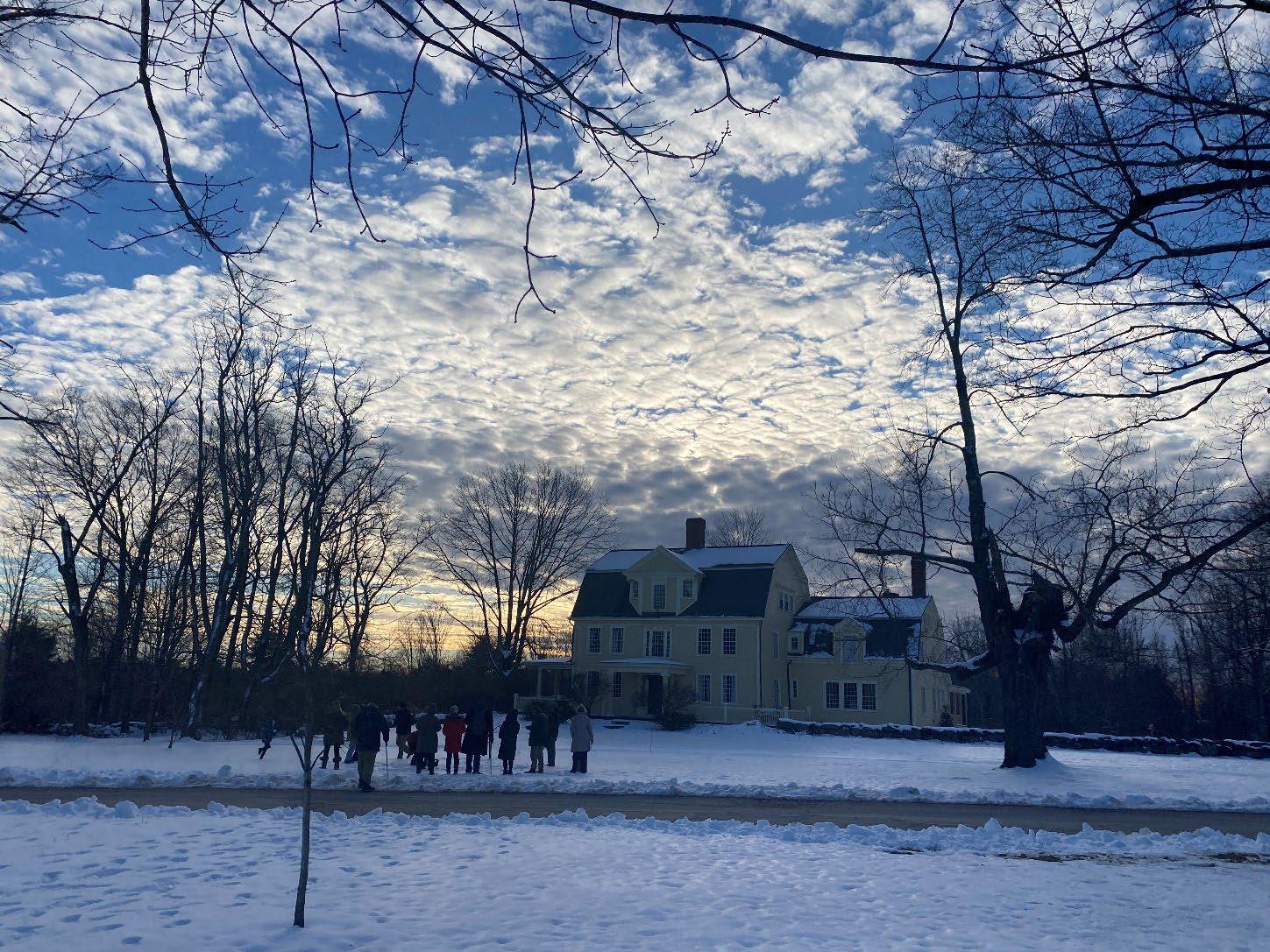
A small gathering, Petersham, Massachusetts.
Gina Quattrochi,
We would like to thank the following for their contributions in drafting this document:
Director of Land Policy and Planning
Executive Office of Energy and Environmental Affairs
Kurt Gaertner
Petersham OSRP Core Team
Anne Cavanaugh
Henry Woolsey
Ari Pugliese
Carly Hutchinson
Tyson Neukirch
Bob Clark
Jennifer Albertine, Kim Tomey, Clarisse Hart
Rich Cavanaugh, Ann Lewis, Clint Shaw, Emery Boose
Aaron O’Connor, Justin Liveresidge
Fraser Sinclair, Ellen Anderson, Andrea Gale
Brian Hall, Aaron Nelson, Glenn Motzkin
Sue Dougherty, Greg Waid, Mary Ann Reynolds
Faculty, staff, and students at the Conway School
John O’Keefe, Jamie Pottern, Chris Company
The residents of Petersham.
A note on maps:
The maps in this document are made with Geographic Information System data from MassGIS and other sources as noted. Map information is believed to be accurate, but accuracy is not guaranteed. Viewers are encouraged to examine the source’s associated documentation or metadata for information related to its accuracy, currentness, and limitations. These maps are for informational and planning purposes only and should not be construed as legal descriptions.

The Conway School is the only institution of its kind in North America. Its focus is sustainable landscape planning and design, and its graduates are awarded a Master of Science in Ecological Design degree. Each year, students from diverse backgrounds are immersed in a range of real-world design and planning projects, ranging from sites to cities to regions.
Table of Contents
1. Plan Summary
2. Introduction
3. Community Setting
4. Environmental Inventory & Analysis
5. Inventory of Lands of Conservation and Recreation Interest
6. Community Vision
7. Analysis of Needs
8. Objectives & Goals
9. Seven-Year Action Plan
10. Public Comments
11. References
Appendix A: 2023 OSRP Community Survey Results
Appendix B: Community Engagement Meeting Agendas
Appendix C: Community Engagement Meeting Results
Appendix D: Core Team Center School Visit
Appendix E: Conservation Strategies and Resources
Appendix F: Quabbin Reservoir Watershed System Public Access Policies
Section 1 Plan Summary
Section 1 Petersham 2024 OSRP pg. 1
Town Common and First Congregational Parish Unitarian, Petersham, Massachusetts
Petersham, Massachusetts, is a rural town with a population of about 1,200 people. It abuts the Quabbin Reservoir, which supplies clean drinking water to three million people, and is almost entirely within its watershed. Because of conservation efforts to safeguard the water quality of the Quabbin, the Commonwealth of Massachusetts owns a large, forested portion of Petersham along the Quabbin shoreline. While the Quabbin Reservoir and the state-owned forest buffer, two miles wide in some areas, offer beautiful scenic views, hiking, and mountain biking trails, Petersham has several other conservation lands that offer additional ecosystem benefits and recreational opportunities to the community, region, and state.
Over 70% of land in Petersham is protected from development, either permanently or temporarily through the Chapter 61 program. Mixed hardwood forests dominate the landscape, while agricultural fields and a few critical wetland and vernal pool habitats are interspersed throughout. Residents value the conservation land in Petersham because it offers scenic views and preserves their rural character, and they also have strong desires to protect the environment and rare species and maintain wildlife corridors. Conservation organizations are very active in the town and in the region and are supported by the community.
This 2024 Draft Open Space and Recreation Plan continues the work of Petersham’s 2014 OSRP, weaving in feedback from a town-wide survey conducted in late 2023, as well as two community engagement sessions hosted by the Conway School team. The vision for Petersham that prevails is one of strong rural character, community and civic engagement, recreation, and a continued appreciation for the open space that Petersham has to offer and its ecological value.
The following four goals summarize Petersham’s open space and recreation ambitions:
1. Petersham will retain its beauty, unique sense of place, and rural character by protecting the health and integrity of its natural assets, including but not limited to its air, drinking water, wetlands, soils, scenic views, working farms, fields, and forests, large blocks of connected forestland, and the diversity of its native flora and fauna.
2. Petersham will enhance the quality, variety, and accessibility of its open spaces and recreational offerings for the health, well-being, safety, and enjoyment of all residents and visitors.
3. Petersham will increase climate-resilient land practices and active community stewardship of its open spaces, public byways, and private lands.
4. Petersham will improve communication among Town departments, committees, and residents to increase public awareness about open space access, inclusive cultural and recreational uses, land conservation, and stewardship.
Section 1 Petersham 2024 OSRP pg. 2
Section 2 Introduction
Section 2 Petersham 2024 OSRP pg. 3
Town Hall, Petersham, Massachusetts.
A. Statement of Purpose
In the winter of 2024, a team of graduate students from the Conway School (the Conway team) was tasked with updating the 2014 Petersham Open Space and Recreation Plan. Towns in Massachusetts must update their OSRPs every seven years to remain eligible for grants from the Division of Conservation Services. Since the last OSRP, there has been close cooperation between Petersham’s Open Space & Recreation Committee (OSRC) and Conservation Commission (CC) to conserve priority open space and accomplish other goals identified. Below is a summary of progress made on the action items identified in the 2014 OSRP.
Conservation Actions
In 2014 a LAND grant conserved 100 acres of the former King property on South Street abutting the Babbitt Wildlife Sanctuary; the land contains 8 acres of prime agricultural soil.
In 2015 the Conservation Commission was awarded a LAND grant in the amount of $242,336 for the 235-acre Gross Farm CR Acquisition Initiative Project on East Street. The property borders Moccasin and Cardinal Brooks, with 30 acres of prime agricultural soils and prime forestland soils. The property provides protection for a critical watershed for the Quabbin Reservoir. Subsequently, a $10,000 grant for incidental expenses was awarded by the Quabbinto-Cardigan Partnership (Q2C).
In 2016, Mount Grace, through its work with the North Quabbin Heritage Landscape Partnership and the federally funded Quabbin-to-Wachusett Forest Legacy Program, conserved the 104-acre Feldman property in Athol, Petersham, and Phillipston, the Hutchinson 51-acre property in Petersham, the 646-acre Chimney Hill Farm (CHF) in Petersham, which abuts Mass Audubon's Rutland Brook Wildlife Sanctuary (CHF is also protected with a Watershed Preservation Restriction held by DCR's Division of Water Supply Protection), and Harvard Forest's 646-acre Tom Swamp Research Forest in Petersham. Tom Swamp is protected with a Watershed Preservation Restriction held by DCR, marking the first time Harvard Forest put a conservation restriction on property it owns in town.
In 2016 East Quabbin Land Trust purchased the 7.2-acre Wilder property now called "Seven Acre Preserve" in Petersham and donated the CR to the Town's Conservation Commission. EQLT says "Management of this land is focused on agriculture and pollinator habitat. The Land Trust hopes to restore the organic matter in the soil to establish healthy nutrient cycling on site for small-scale vegetable farming. In addition, volunteers established a 100’x100′ pollinator meadow near the kiosk in 2019. This is a multi-year process focused on seeding native grasses and wildflowers to support declining pollinator populations." (Seven Acre Preserve)
The Town does not have the resources to pursue every action item suggested in the last OSRP, but it has continued to work with existing organizations. For example, the Town collaborated with the North Quabbin Regional Landscape Partnership, local and statewide land trusts, Harvard Forest, and State agencies to encourage private forest landowners who are not enrolled in Chapter 61 or 61A or have Conservation Restrictions to prepare forest management and stewardship plans.
Section 2 Petersham 2024 OSRP pg. 4
Recreation Actions
There were also some efforts to connect trails in town; begun in 2015, The Bob Marshall Trail in Petersham "is a little over two miles long connecting the Gould Woodlot at Harvard Forest to the Harvard Pond/Tom Swamp Tract. The section of the trail through Petersham State Forest remains to be completed as a memorandum of understanding is required from the DCR before work can begin. The State archeologist reviewed the section of trail through Petersham State Forest and a determination as to possibly changing the route is necessary before a memorandum of understanding from DCR can be obtained before work can begin” says the OSRP committee in annual reports.
In 2016 a footbridge over Nelson Brook was installed, opening access through the northern portion of the trail.
Some volunteer maintenance happened at the Babbitt Wildlife Sanctuary several years ago, but parking and trail construction have not been addressed. At the Davenport Property, the CC is currently tackling work on the Davenport Pond Dam and discussing improving the entrance, parking area, and trails. Equestrian use at the Davenport Property has since been discouraged due to wetlands and wetland trail crossings on the property.
Residents still say they would like places to swim in town and because of the last OSRP the OSRC explored a swimming option in Athol at the 500-acre Morgan Memorial Goodwill Industries' Fresh Air Camp Site (Mount Grace has conserved 330 acres of the site), but it wasn't pursued. The OSRC also explored a swimming option at Brown's Pond in Petersham. The DCR, which has jurisdiction over waterbodies in the Quabbin Watershed, was willing to allow swimming in the pond (which is privately owned) if there were no structures or facilities built. While owners allowed swimming in the pond many years ago, safety and other concerns have disinclined the owner to allow it again. Devoted residents monitor and maintain Harvard Pond for safe skating each winter, temperature and weather permitting.
Planning, Policy, & Programming Actions
Currently the Conservation Commission is discussing developing a local wetlands bylaw. The Town is also continuing to certify vernal pools in Petersham through the Massachusetts Natural Heritage and Endangered Species Program so that they may be protected by state regulations. There are 14 certified vernal pools in town. In 2017 the Town certified one vernal pool on the Selden property. A pair of vernal pools were certified at the Women's Federated Club State Forest in 2018.
Petersham has continued to prepare and adopt a set of guidelines for the future management and maintenance of town historic scenic roads that addresses issues such as the paving of roads; the planting, thinning, and pruning of street trees; and the placement of utility poles.
Lastly, Petersham has ensured the continuation of the Natural History Programs at the Petersham Center School.
Section 2 Petersham 2024 OSRP pg. 5
B. Planning Process and Public Participation
The Town of Petersham received a Planning Assistance Grant from the MA Executive Office of Energy and Environmental Affairs to draft a new Open Space and Recreation Plan. The Town used the grant funds to contract with the Conway School to draft the plan.
The plan has been created in collaboration with Petersham’s Open Space and Recreation Committee and interested Petersham residents. The OSRP committee and core team working with the Conway students included Anne Cavanaugh (Chair); Henry Woolsey, who has lived in Petersham for thirty years and formerly managed MassWildlife's Natural Heritage and Endangered Species Program (Conservation Commission); Ari Pugliese, former owner of the locally iconic Country Store; Carly Hutchinson, recently returned Petersham native who has conducted research on the impacts of climate change on marginalized communities in Puerto Rico (Zoning Board of Appeals); and Tyson Neukirch, Petersham farm owner and Conway School alum from the Class of 2023 (Tyson is not on the OSRP committee but was part of the core team). The Conway team included Conway School graduate students Gina Quattrochi, Leah Stanton, and Eric Rose.
In the fall of 2023, before Conway students were involved in the project, the core team sent out a town-wide survey about open space and recreation opportunities and goals for the future. The survey received 209 responses, which is a large response rate for a town of 1,200 people. In January 2024, the Conway team began work on the project. The Conway team and core team met weekly and planned two community engagement meetings to receive further feedback from residents on their goals and desires for the updated OSRP. The first meeting was held at Town Hall and had 70 attendees in person and 11 by Zoom. The second meeting was held in the Center School and had around 30 attendees in person and six on Zoom. Both meetings were held on Saturday afternoons. The meetings were advertised through Petersham’s robust Facebook network, as well as on the town website and through fliers posted all over town.
The first meeting asked attendees to divide into small groups and discuss their concerns and desires regarding conservation and recreation. The second meeting included several activity stations and aimed to elicit feedback related to trail access and connectivity, open space and recreation goals, a shared vision statement, ideal forms of development, and desired recreation activities. After the meetings, the Conway students carried out the research and writing of the report with the support of the core team, Conway faculty, and interviews with relevant stakeholders and Petersham residents. Results from the meetings can be found in Appendix C.
Section 2 Petersham 2024 OSRP pg. 6
Section 3
Community Setting
Section 3 Petersham 2024 OSRP pg. 7
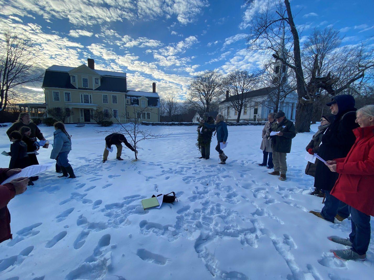
Apple Howling event, Petersham, Massachusetts.
A. Regional Context
Petersham is a proudly rural community abutting the eastern portion of the Quabbin Reservoir in north-central Massachusetts. The town is almost entirely within the Quabbin Reservoir Watershed. Water tends to move southwest to the Quabbin, then down the Swift River to the Chicopee River and then to the Connecticut River. Just a small area near the town’s northern corner drains to the Miller’s River, which bypasses the Quabbin on its way to its confluence with the Connecticut River, well north where the Chicopee River meets the Connecticut.
The physical characteristics of Petersham are in keeping with those of its immediate neighbors, and many other towns in Massachusetts. The rolling hills are mostly covered by forest cut through with streams and punctuated by scattered wetlands. The elevation ranges from 476 to 1,365 feet above sea level, with an average of 823 feet above sea level (Topographic Maps). The town center is located on a ridge in the center and the lowest elevations are to the west, near the Quabbin.
What truly sets Petersham and its immediate neighbors apart from the rest of the state is their relationship to the Quabbin. The Quabbin Reservoir, through the Massachusetts Water Resource Authority, supplies water to over 3 million people in the greater Boston area. Chicopee, South Hadley Fire District #1, and Wilbraham, all southwest of the Quabbin, all receive Quabbin water via the Chicopee Valley Aqueduct (Mass.gov DCR Watershed Plans; see Regional Context Map 3-1: MWRA Water Service). The protection of this watershed is of great importance because it directly affects the quality of drinking water for so many people. Consequently, the Massachusetts Department of Conservation and Recreation owns and regulates a great deal of the land throughout the watershed. Other state and non-state agencies are also involved in protecting this critical resource for the sake of core habitat preservation as well as safe-guarding one of the largest unfiltered drinking water sources in the United States. Because of these efforts Petersham and its neighbors are part of a massive stretch of relatively intact forest that reaches from Massachusetts into the mountains of Vermont and New Hampshire.
Petersham, by area, is the third largest town in Massachusetts (MassGIS Data: 2020 U.S. Census Towns) Of Petersham’s 43,675 acres (68.2 square miles) over 70% are in some form of conservation protection; of the 54.9 square miles of land (35,123 acres) in Petersham, the Quabbin itself covering the remaining 8,552 acres (13.4 square miles), 87% (30,414 acres) is forested or shrubland (MassGIS Data: 2016 Land Cover/Land Use). The forest is a major component of Petersham’s rural character, visible along most of the roads, which radiate out from the hub of municipal buildings, residences, businesses, and schools that are in the town center. Small, local, and home-based businesses are scattered throughout the town while farmland and residences line the main radials with mainly residences spread along the smaller in-between roads. Development has been concentrated in these areas because so much of the town is conserved (See Map 3-2: Land Cover in Petersham, MA 2016)
Section 3 Petersham 2024 OSRP pg. 8
Map 3-1 Regional Context: MWRA Water Service
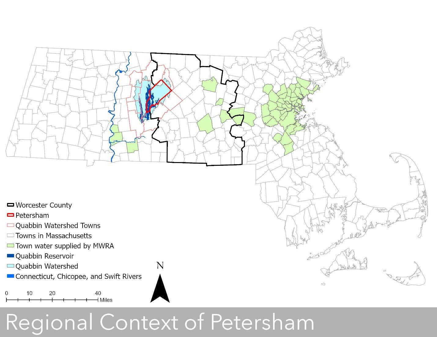
Petersham (red outline) lies almost entirely in the Quabbin Reservoir Watershed (light blue). The Quabbin Reservoir (dark blue within the light blue) supplies drinking water to forty-eight of the most densely populated towns and municipalities in Massachusetts (See Map 3.6: Population Density of Massachusetts Towns) Sources: MassGIS Data: 2020 Census Towns, Counties, MWRA Water/Sewer Service Areas, NRCS HUC Basins (8, 10, 12), MassDEP Hydrography (1:25,000).
Section 3 Petersham 2024 OSRP pg. 9
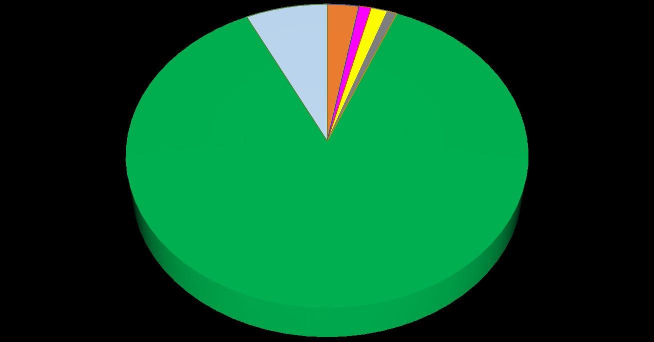
Chart 3-1: Petersham 2016 Land Cover, Total Acreage = 43,675 acres


LAND COVER IN ACRES
Charts 3-1 and 3-2 summarize land cover data from MassGIS 2016 Land Cover/Land Use. Forest, forested wetlands, and low tree-cover shrublands are grouped together within the forest category. Bare land in Petersham, according to satellite imagery, is most often farm fields and has been grouped with cultivated and pasture/hay as agricultural. Whereas Chart 3-1 considers the coverage in relation to the entire town, Chart 3-2 considers coverage of just the land mass of Petersham (See Map 3-2: Land Cover in Petersham, MA 2016).
Chart 3-2 Petersham 2016 Land Cover, Excluding Water, Total Acreage = 35,123 acres


LAND COVER EXCLUDING WATER
Section 3 Petersham 2024 OSRP pg. 10
2% Agricultural 978.6 acres <1% Developed 379.1 acres 1% Grassland 510.6 acres <1% Impervious 309.6 acres 70% Forest 30413.7 acres 19% Water 8552.4 acres 6% Wetland 2531.4 acres
3% Agricultural 978.6 acres 1% Developed 379.1 acres 1% Grassland 510.6 acres 1% Impervious 309.6 acres 87% Forest 30413.7 acres 7% Wetland 2531.4 acres
Map 3-2: Land Cover in Petersham, MA 2016
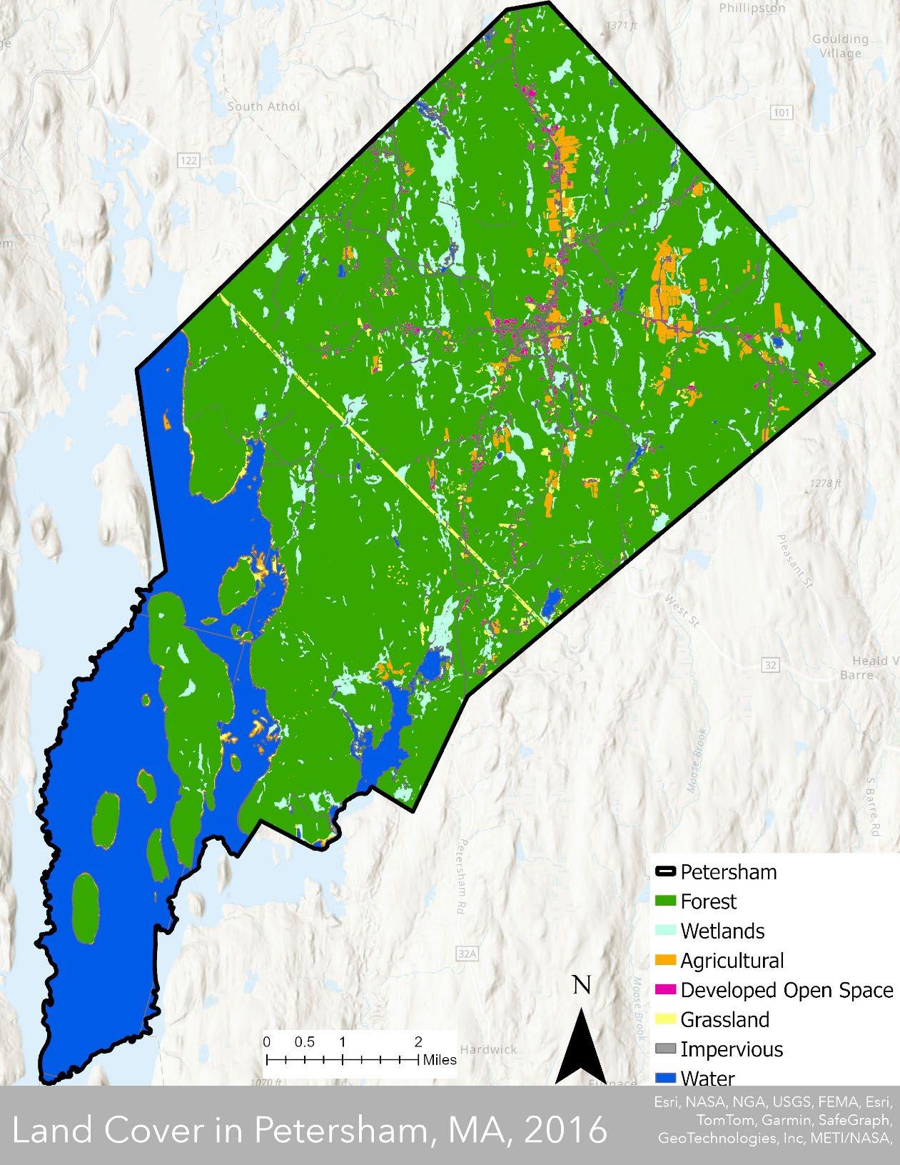
Forest, forested wetland, and low tree-cover-like shrublands are categorized as forest. Bare land, according to satellite imagery, is most often farm fields and has been grouped with cultivated and pasture/hay as agricultural. Nearly a fifth of Petersham is covered by water and nearly 90% of the remainder has tree cover. This provides a remarkable amount of open space in Petersham. The straight yellow line that runs northwest to southeast is the grasslands resulting from a utility right-of-way. Pockets of orange along the Quabbin are exposed shoreline.
Sources MassGIS: 2020 U.S. Census Towns, 2016 Land Cover/Land Use.
Section 3 Petersham 2024 OSRP pg. 11
State Routes 32, 32A, and 122 pass through the town center and connect Petersham to larger population centers such as Ware, Barre, Orange, and Athol, all within a half-hour drive of the town center. State Route 101 extends from Route 32 just north of the town center to nearby Gardner, about a twenty-minute drive. Many residents drive to these nearby communities for groceries, gas, and work Orange, Athol, and Gardner lie on State Route 2 which runs west-east from North Adams, MA, near the New York border, to Boston (See Map 3-3: Massachusetts Cities Near Petersham)
Map 3-3: Massachusetts Cities Near Petersham
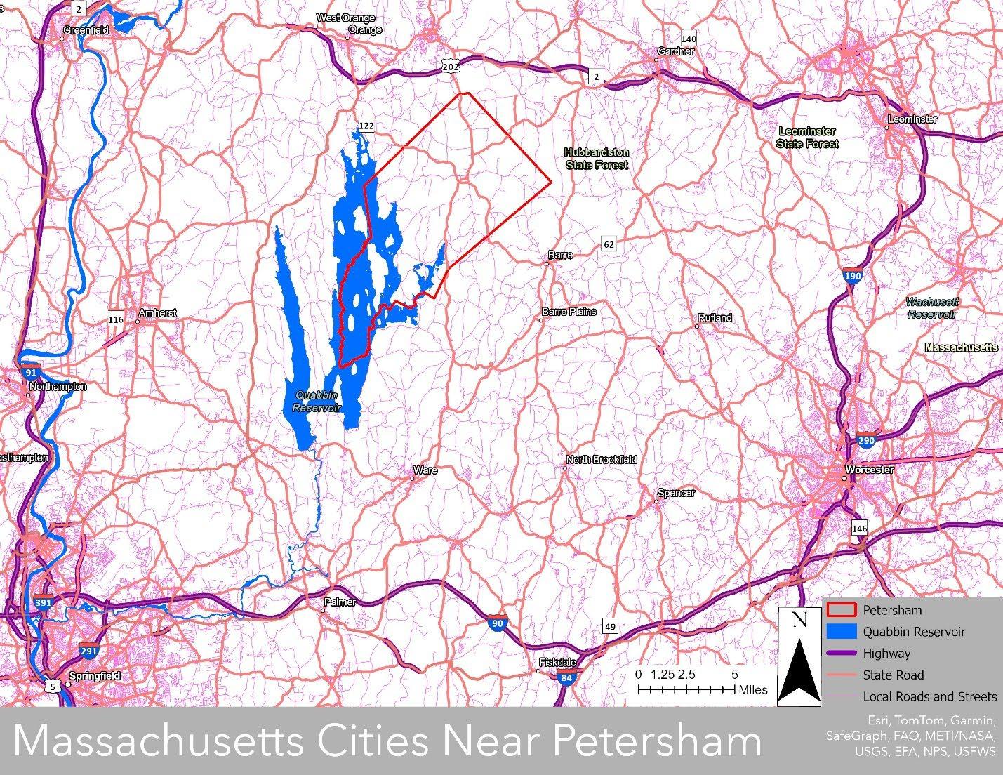
Sources: MassGIS Census Towns, MassGIS-MassDOT Roads, 2020 Census TIGER Roads, MassDEP Hydrography (1:25,000)
While Petersham itself lacks some of the conveniences and necessities of a larger population center such as a large-scale grocery store, movie theater, or gas station, these amenities exist in the neighboring communities. But Petersham does boast a vibrant and historic Country Store. Owned by East Quabbin Land Trust and protected in perpetuity as a country store since 2013, the Country Store has plenty of grocery items on the shelves for town residents as well as recreational bicyclists and hikers visiting Petersham. The Petersham Memorial Library hosts movie nights. Residents can enjoy live music on the open green of the Town Common. Hiking, walking, biking, birdwatching, gardening, boating, cross-country skiing, lawn games, fishing,
Section 3 Petersham 2024 OSRP pg. 12
and skating are all popular recreational activities in Petersham. The abundant natural resources and recreational opportunities are attractions for people living outside of Petersham as well.
The most popular recreational activities are walking and hiking on the town’s scenic roads and trails. Route 122 is one of fourteen Massachusetts Scenic Byways, a designation reserved for roads with scenic, historic, or cultural importance. But many Petersham roads feature the type of historic homes, stone walls, cemeteries, pastureland, and forest which make Route 122 so special. There are trails at Harvard Forest, Petersham Town Forest, Petersham State Forest, Brooks Woodland Preserve, Federated Women’s Club Forest, Swift River Reservation, to name a few. Much of the land these trails are on is conserved open space held or managed by state, non-profit land trusts, and other organizations dedicated to protecting the region’s natural ecosystems. These entities include some of the biggest landholders in the town.
Table 3-1: Largest Landowners in Petersham
David M. Trustee
Society, Inc.
Hill Farm, LLC
John K. & Maniha Barbara B.
Total Area of Petersham: 43,673
Total Land Area of Petersham: 35,123
Source: MassGIS Data: Property Tax Parcels
The town of Petersham lies within a large network of conserved land and habitat corridors in the northeastern United States. Many organizations work collectively and separately towards protecting the open spaces of this network, including Massachusetts Department of Conservation and Recreation, Massachusetts Department of Fish and Wildlife, United States Forest Service, Harvard Forest, East Quabbin Land Trust, Mass Audubon, Mount Grace Land Conservation Trust, Mass Land Trust Coalition, and the Trustees of Reservations. All have vested interests in managing and stewarding the land for the well-being of the land, water, plants, animals, people, and ecosystems that they all share.
Section 3 Petersham 2024 OSRP pg. 13
Owner Acreage % Total Area % Land Area Commonwealth of Massachusetts 21,870 50% 62% President & Fellows of Harvard College 3,232 7% 9% Trustees of Reservations 1,165 3% 3% Desmarais,
842 2% 2% Mass Audubon
805 2% 2% Chimney
678 2% 2%
1% 2% Township
505 1% 1%
Maniha,
533
of Petersham
B. History of the Community
Before the Quabbin Reservoir or the community of Petersham were created, the lands that they now occupy were the homeland of the Nipmuc or Fresh Water people. Historically and still today the Nipmuc people are represented by several bands including Hassanamisco and Chaubunagungamag who possess deep and historical cultural and kinship ties. The Nipmuc people moved seasonally between homeplaces hunting, gathering, and actively practicing forms of agriculture connected to seasonal cycles. They, as with most northeastern woodland tribal nations, were highly engaged in a symbiotic relationship with the land that sustained them (History Hassanamisco Indian Museum)
As Europeans arrived in the Americas, they brought a variety of diseases new to Indigenous peoples. Those diseases spread through the native population even faster than the Europeans traversed the lands. It is possible that as much as 95% of the indigenous population died as a result (Ehrenpreis and Ehrenpreis). There were an estimated 5,000 to 6,000 Nipmuc people left alive as the Europeans invaded their homelands (Holley).
The history that follows draws from the 2014 OSRP which in turn “paraphrased from the 1952 study entitled Planning One Town: Petersham – A Hill Town in Massachusetts, with more recent history gleaned from various local source,” Petersham historical Society’s Petersham, Massachusetts: A Concise Timeline, and Mabel Cook Coolidge’s The History of Petersham, Massachusetts
The Massachusetts General Court in 1733 granted land to former soldiers as recompense for engaging in Lovewell’s War, a genocidal campaign against the native population wherein “the General Court of Massachusetts offered a bounty of one-hundred pounds, for every Indian Scalp which should be brought in” (Coolidge 23). The land they were granted included Nichewaug, a homeplace of the Nipmuc people. The colonizers established a central village high on the ridge and it was initially known as the Settlement at Nichewaug, appropriating the Nipmuc name. Coolidge reports “the supposition” that the Nipmuc people lived in areas of lower elevation with the two groups coexisting “in harmony” (Coolidge 22). The addition of ten men to the settlement garrison at “Nichiwoag [sic]” indicates that relations were not harmonious (Lord). The payment of even more scalp bounties into the 1750s is even further evidence of the bloody violence directed towards Indigenous peoples (Bounty Teachers Guide). The Settlement at Nichewaug, combined with other land grants rewarding the pursuit of scalp bounties to other campaigners, was eventually incorporated as the Town of Petersham.
Section 3 Petersham 2024 OSRP pg. 14
Map 3-4: Homelands of the Nipmuc People
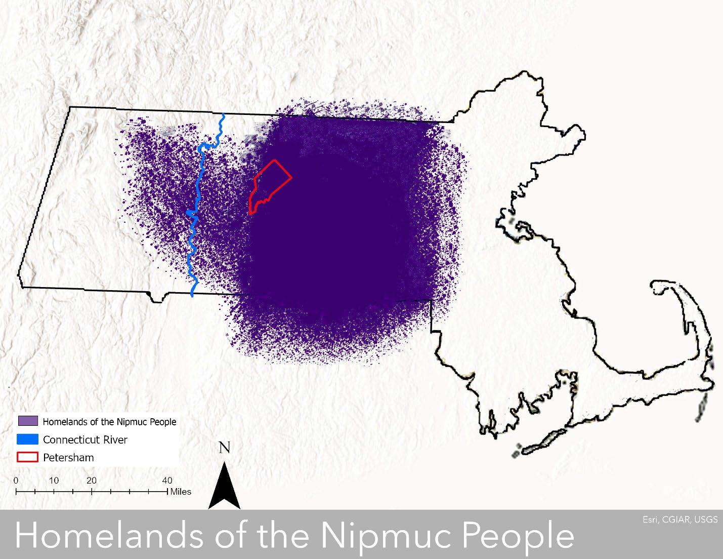
Homelands of the Nipmuc People was created using other maps, listed in Section 11, delineating Nipmuc territory prior to colonization. Purple coloring was added to an outline of Massachusetts wherever a map indicated the presence of the Nipmuc so that where the maps coincided is colored solidly and where the maps did not coincide there is a spattering of color. One flaw inherent in the process is that some of these maps may have been source material for the others. The intent is to acknowledge the presence of the Nipmuc in all these places because municipal and state borders are a colonial imposition and because the territory shifted over time, especially as colonizers pushed Native peoples from their homelands. Sources: MassGIS Census Towns, MassDEP Hydrography (1:25,000)
Section 3 Petersham 2024 OSRP pg. 15
European-style agriculture was slow to develop in Petersham because there was better farmland in the Connecticut River valley and elsewhere. Nonetheless, 80% of the town’s land was in agricultural use by the middle of the nineteenth century, meaning that most of the forest cover had been removed. In its place were grazing lands, small saw- and gristmills, and other smallscale cottage industries. But the railroad never came to Petersham, skirting it on all sides. Consequently, Petersham’s industries became less competitive and dwindled. People began leaving to find work elsewhere, so that a peak population of 1,775 people in 1840 dropped to a low of 642 in 1920. Much of the farmland reverted to forest and the artifacts of the colonial settlers can be found throughout the town in the form of walls, cemeteries, foundations, and cellar holes. But the railroads were close enough that Petersham was accessible to the wealthier residents of Boston and other cities. They began to establish summer homes in the cooler countryside to escape the heat islands of the time. The Nichewaug Inn was an iconic stop for summer visits to Petersham.
Meanwhile, nearby towns Athol and Gardner, on the railroad line, began to develop as industrial hubs, providing jobs to nearby communities, including Petersham. Whereas Petersham, Athol, and Gardner each had a population between 1,000 and 2,000 people in 1840, by 1940 Petersham had just 923 residents compared to 11,180 in Athol and 20,206 in Gardner. Some Petersham families continued to farm, supplementing their income with jobs in places like Athol and Gardner. Some urban families moved into Petersham farmhouses that were being abandoned. By the early 1900s, a new demographic had begun to appear in the shrinking community the urban-employed. The automobile accelerated the trend and began the age of the commuter.
A new era for Petersham began in 1930 when the construction of the Winsor Dam and Goodnough Dike, both along the Swift River, commenced. Four towns Dana, Enfield, Greenwich, and Prescott were in the path of the planned reservoir so they were disincorporated and absorbed by the surrounding towns. The process displaced 1,500 people. The completion of both Dike and Dam in 1939 ushered in the existence of the reservoir as the Swift River slowly filled the valley it had once freely flowed through. Most of Dana, about 10,000 wooded acres now owned by DCR and managed by the Office of Watershed Management, was annexed to Petersham. Even more agricultural land successioned to forest. Scenic Route 22 around the Quabbin Reservoir saw its first use in 1937.
The number of summer residents declined rapidly in the middle of the twentieth century prompting the Planning One Town report of 1952 to declare that “Petersham summer houses on the market are selling at depression-prices if at all.” The Sisters of Maria Assumpta converted the iconic Nichewaug Inn into the Academy of Maria Assumpta, a high school for girls in 1951 but it closed in 1972. The former Nichewaug Inn then changed ownership but remained unused. The Town acquired the property in 2007 and later commissioned the Nichewaug Inn Market and Feasibility Analysis for housing on the site. All buildings except for a brick garage were demolished in 2022 and the 6.6-acre site is now mainly turf. The site’s future use is a topic of frequent discussion.
Section 3 Petersham 2024 OSRP pg. 16
Section 3 Petersham 2024 OSRP pg. 17
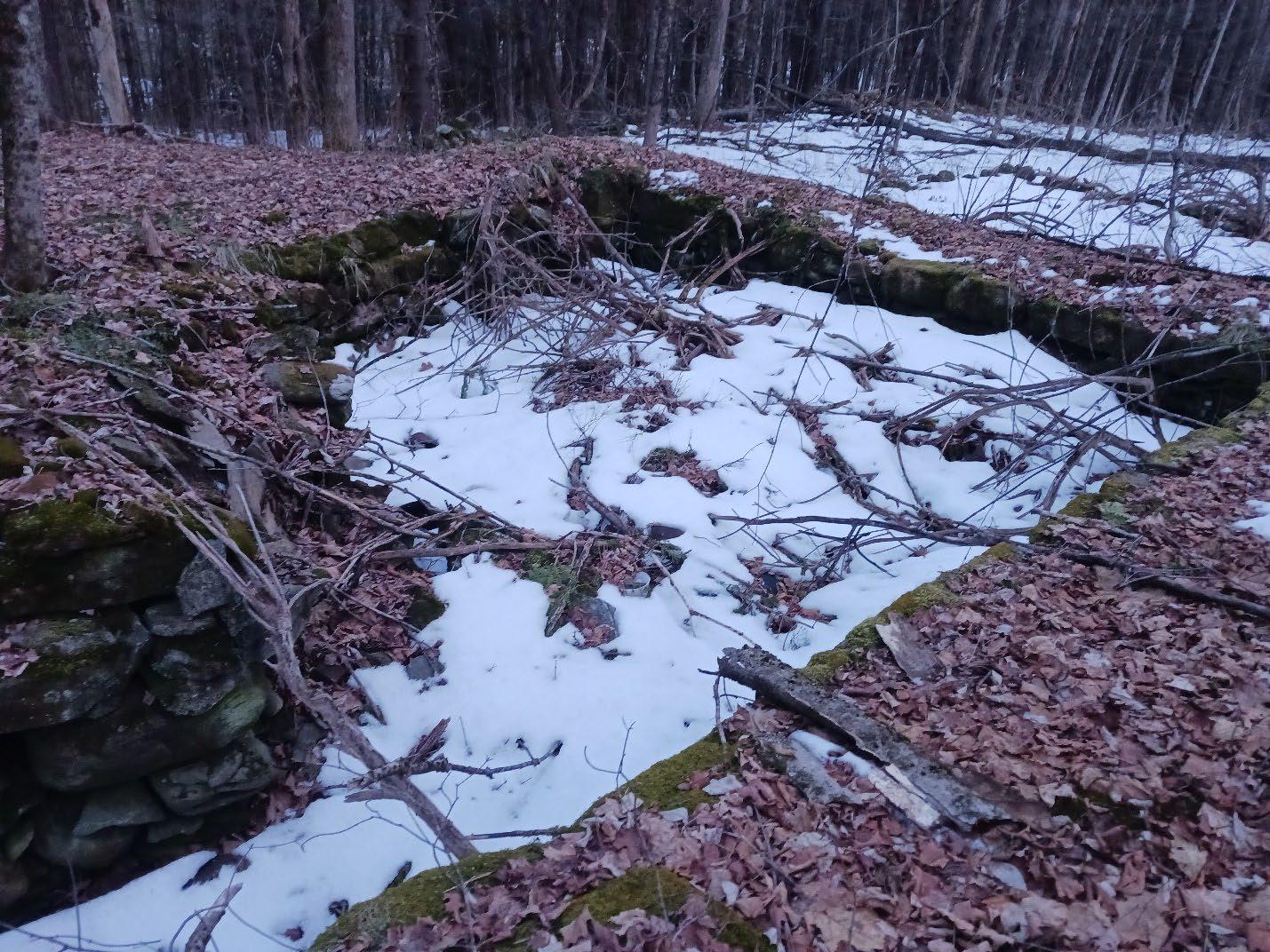
An abandoned cellar hole surrounded by woods, Petersham, Massachusetts.
C. Population Characteristics
Petersham’s 2020 population of 1,194 is well below its 1840 peak of 1,775 and well above its 1920 low of 642 (U.S Census Data, Coolidge). The peak and low figures are pre-Quabbin, when Petersham was about 10,000 acres smaller. While Petersham’s population has increased by nearly 18% over the last fifty years, it has done so at an average rate of less than 1% per year. At no point since 1970 did the ten-year population-change exceed a rate of 5%, and between 2010 and 2020 it decreased by 3%. The accompanying table shows populations for towns within the Quabbin watershed or within four miles of Petersham. Although many of them have experienced dips throughout the last fifty years there is no clear pattern. It remains to be seen whether Petersham’s population will increase or decrease in the future If these trends continue, however, the rate of change is likely to be small and there is not likely to be a shift in open space or recreation needs. Subsection D explores variables that may significantly increase development pressure and increase the town population.
Source: MassGIS Data 2020 U.S. Census Towns
Section 3 Petersham 2024 OSRP pg. 18
Town 1960 1970 1980 1990 2000 2010 2020 Wendell 292 405 694 899 986 848 924 New Salem 397 474 688 802 929 990 983 Petersham 890 1014 1024 1131 1180 1234 1194 Pelham 805 937 1112 1373 1403 1321 1280 Shutesbury 265 489 1049 1561 1810 1771 1717 Phillipston 695 872 953 1485 1621 1682 1726 Hardwick 2340 2379 2272 2385 2622 2990 2667 Hubbardston 1217 1437 1797 2797 3909 4382 4328 Barre 3479 3825 4102 4546 5113 5398 5530 Orange 6154 6104 6844 7312 7518 7839 7569 Templeton 5371 5863 6070 6438 6799 8013 8149 Ware 7517 8187 8953 9808 9707 9872 10066 Athol 11637 11185 10634 11451 11299 11584 11945 Belchertown 5186 5936 8339 10579 12968 14649 15350
Table 3-2: Populations of Towns near Petersham, 2020 See Map 3-5
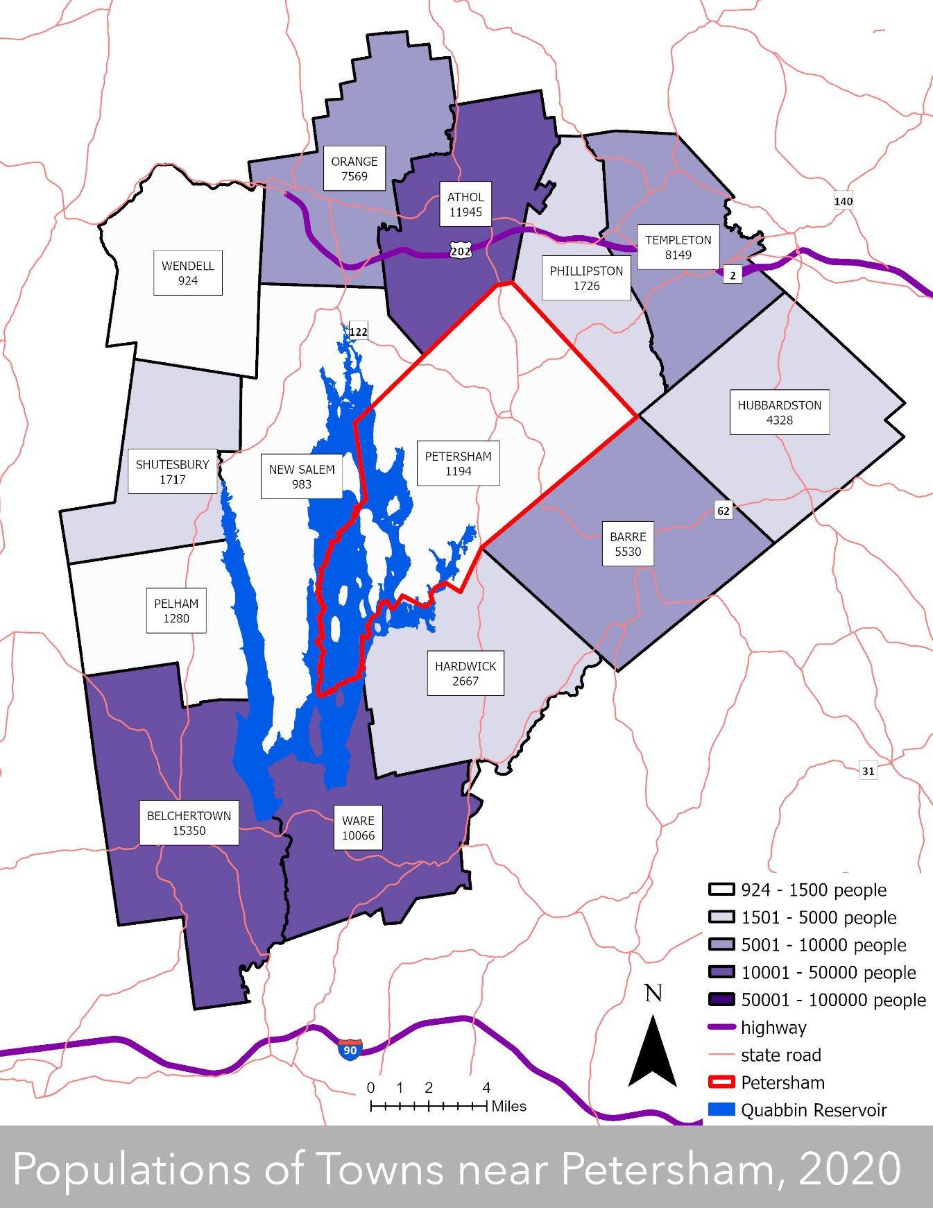
Petersham is one of Massachusetts’ largest towns by area and has one of the lowest populations in the state. Populations of nearby towns vary significantly, making direct comparisons between neighboring towns more difficult. Sources: MassGIS Census Towns, MassGIS-MassDOT Roads, 2020 Census TIGER Roads, MassDEP Hydrography (1:25,000)
Section 3 Petersham 2024 OSRP pg. 19
Map 3-5: Populations of Towns near Petersham, 2020
Only thirty-two Massachusetts towns have smaller populations than Petersham, yet it has the third largest area in the state. Only seven other towns have a less dense population, and it has the same density as neighboring New Salem (See Map 3-6: Massachusetts Population Density) Over half ($2,263,256) of the Town’s Fiscal-Year-2022 General Fund Revenues was derived from property taxes (FY22 Town of Petersham Annual Reports, 41). Just over five-hundred thousand dollars (12%) of town revenue came from state PILOT (Payment-In-Lieu-Of-Taxes) payments. The state owns 21,870 acres of Petersham’s 43,675 acres, which is almost exactly half of the surface area of Petersham (MassGIS Data: Property Tax Parcels). Over 70% of Petersham is under some form of conservation protection and is either exempt from property taxes or has reduced rates. The implication is that a relatively small population is responsible for providing services over a large area with a reduced tax base. But the presence of conserved land affords residents the potential of recreational access, a high degree of protection for natural ecosystems, and a reduced maintenance burden since much of the conserved land does not require the same level of infrastructure as developed areas do.
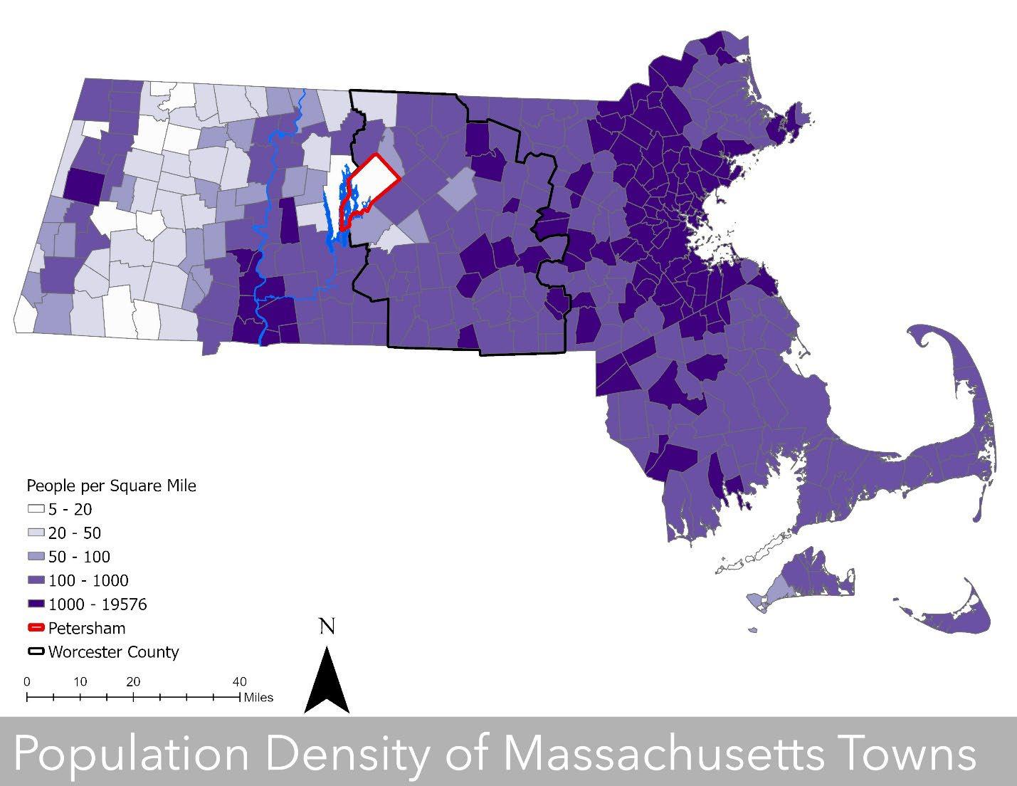
Petersham’s population density is among the lowest in the state. This is partly the result of major transportation routes bypassing it and conservation efforts around the Quabbin Reservoir. Sources: MassGIS Census Towns, MassGIS Counties, MassDEP Hydrography (1:25,000)
Section 3 Petersham 2024 OSRP pg. 20
Map 3.6: Population Density of Massachusetts Towns
Employment statistics indicate a labor force of 680 and an unemployment rate of 4.7% as of December 2023 (Mass.gov Labor Market Information). Petersham has a median household income of $104,205 and a per capita income of $44,519. A relatively high median income and low poverty rate indicate that it may be reasonable to believe that some residents have disposable income to spend on recreation. It could also be inferred that the people who are not part of the labor force might have more time for recreation.
The poverty rate in Petersham is 6.5%. That compares to 10.4% in Massachusetts and 10.6% in Worcester. With a majority white population and no concentrated areas of inequity, Petersham has no designated Environmental Justice population. Despite this, and a relatively low poverty rate, there are nonetheless over seventy people living below the poverty line. In 2023, an individual would be living on less than $15,000 per year and a family of three on less than $25,000 per year (HHS Poverty Guidelines).
As of 2020, the percentage of Petersham residents over 65 is higher than that of many of its comparably sized neighbors, and substantially higher than that of the state or Worcester County. A relatively low percentage of those individuals are living alone, though. As evidenced by the percentage of individuals over 16 years old, Petersham has a smaller percentage of young people than the state or county, but a higher percentage than some comparably sized neighboring towns. Individuals under 16 or over 65 account for 42% of the population, which is about the same as the portion of residents not in the labor force. The younger and elder populations may have more time for recreation when school is not in session (for the young) or during retirement (for the older people). Individuals in these two age groups might have a greater need for recreational opportunities. The aging population may have greater accessibility needs and they may shift from participating in active recreation to more passive activities (U.S. Census Bureau).
Chart 3-3: Age Demographics in 2020
Chart 3-3 compares Petersham’s demographic percentages to those of neighbors with similar population sizes, as well as the state and Worcester County. Source: U.S. Census Bureau
Section 3 Petersham 2024 OSRP pg. 21
MA Worcester County Petersham town, Worcester County New Salem Shutesbury Pelham Hardwick Phillipston Demographic % % % # % % % % % Total population 7,029,917 862,111 1,194 983 983 1,717 1,280 2,667 1,726 Selected Age Categories 16+ 83.0% 81.9% 84.3% 854 86.9% 85.4% 86.6% 83.7% 83.0% 18+ 80.6% 79.3% 82.3% 825 83.9% 82.6% 84.6% 81.0% 80.1% 21+ 76.2% 74.9% 80.2% 794 80.8% 80.6% 81.6% 77.6% 77.1% 62+ 21.4% 20.4% 31.9% 324 33.0% 29.3% 34.1% 26.8% 23.1% 65+ 17.5% 16.4% 26.0% 240 24.4% 23.9% 28.9% 21.1% 17.3%
TYPE Total households 100.0% 100.0% 100.0% 427 100.0% 100.0% 100.0% 100.0% 100.0% Living alone 16.4% 14.6% 10.6% 63 14.8% 12.4% 12.3% 13.6% 9.3% 65+ Living Alone 8.3% 7.4% 6.9% 32 7.5% 7.9% 7.9% 9.2% 4.7% Households with individuals <18 28.0% 29.9% 23.2% 88 20.6% 26.1% 24.4% 25.7% 30.0%
with individuals 65+ 32.0% 30.4% 48.4% 179 41.9% 42.4% 48.9% 36.4% 34.7%
HOUSEHOLDS BY
Households
D1. Growth and Development Patterns
Petersham is a quintessential New England village. It began on land wrested by settlers from the Nipmuc, growing into a small town center with spired churches, an open-floored town hall, a country store, a library, a town common, and large historic homes. Half of the homes in town were built before 1939 (U.S. Census Bureau), with many in the center of town being older yet.
Most of the countryside was denuded of vegetation for the timber industry, sheep and cattle grazing, and growing crops in the late eighteenth- and early nineteenth-centuries. Transportation shifted to new avenues like canals and barges as the nineteenth century progressed, increasing access for more metropolitan areas to cheaper goods from other parts of the country. Clearcutting stalled logging by the 1850s. Petersham, without access to these new means of transportation, became a less profitable place to make a living through agriculture or forestry or the mills that processed the products for these industries. As many people began to work outside Petersham or leave entirely, the forests outside of the town center began to grow back, swallowing stone walls, buildings and other artifacts of the larger Petersham community. Petersham’s agriculture did persevere, albeit on a smaller scale, where there was better soil and proximity to roads. Abandonment of the other agricultural lands in the early to middle of the 1800s allowed forests to re-establish. As the trees returned, so did logging, but at a more measured pace. In the early 1900s Harvard University established Harvard Forest in part as “a demonstration of practical sustained forestry” (History| Harvard Forest).
Agriculture and forestry are still important aspects of Petersham’s identity. Pastures, hayfields, and some crop fields line many of the roads leading into the town center. Private forest interests, the state, and Harvard Forest have all taken advantage of the regrown forest as a source of timber. The focus of forest management has been shifting, though, as the importance of forested landscapes have become clearer and more valued in the face of climate change. Harvard Forest and Massachusetts both conduct critical research about how to help forests sequester carbon (New England Forests, Harvard Forest; Managing Forests, Mass.gov). The results are a shift to forest management which prioritizes forests as ecosystems instead of commodities, with less logging.
D2. Infrastructure
Petersham has approximately seventy miles of roads with main routes radiating from the town center and smaller roads and streets connecting them. Some of these roads are unpaved. Roads, or portions or roads, without homes or the need for access to homes are closed for the winter to reduce winter plowing and sand and salt use. This reduces non-point-source pollution and wearand-tear on the road. Many of the non-state roads are covered under the Town’s Scenic Roads By-law aimed at protecting the viewshed, shade trees and stone walls along the roadsides. It does not address the road surface and it has been described by residents as having little by way of enforcement mechanisms. There is neither bus service to Petersham nor public transportation within town. Transportation is primarily by private vehicles and some people use bicycles. There are no bicycle lanes in the town.
Section 3 Petersham 2024 OSRP pg. 22
Nevertheless, organized bicycle groups frequently use the main highways, especially Routes 32, 32A, Scenic Byway 122. There are tours on highways surrounding the Quabbin Reservoir. There are no bicycle lanes on these highways and Route 122 has no shoulders. This can present dangerous circumstances when automobiles vie with bikers for space on the roads. Petersham Common has become a destination for bicyclists to rest and enjoy lunch and refreshments at the Country Store.
Universal access sidewalks extend from the Common along Route 32 approximately one-half mile north to the beginning of North Street, and south approximately one-quarter mile to the intersection of Route 122. A sidewalk also extends from the Common along the north side of West Street to the junction of Hardwick Road, approximately one-third mile. Improvements and expansion of sidewalks would provide increased, safer mobility for an ageing population.
Petersham does not have municipal water supply or wastewater systems. There are public water supplies in the form of drilled wells at the Petersham Center School and in town at the Town Office Building and Town Hall. All public facilities and private residences have individual wells and septic systems.
There is a stormwater system of just over one hundred catch basins and drop inlets. Some are in the center of town and along Routes 122, 32, and 32A. It is possible that they daylight individually or connected to isolated groups of fewer than five, although that is uncertain. Storm drains are possible sources of non-point-source-pollution in the form of de-icing agents used on the roads as well as other contaminants which might be deposited on the roads by automobiles. These can damage aquatic and non-aquatic habitats as well as interfere with water quality in the Quabbin.
There are twelve dams within Petersham and another seven immediately adjacent. (See Map 37: Dams within 2,000 feet of Petersham, MA) Of these, three inside and one just outside of Petersham would pose a significant threat if they were to fail as per their hazard code designation by the Massachusetts Office of Dam Safety (MassGIS Data: Dams). The hazard code represents the potential loss to life and property if the dam were to fail. Damns are categorized as having a High, Significant, or Low Hazard Code. This is not a designation of the dam's structural soundness. The Condition Assessment does represent the structural soundness of the dam. Dam condition is categorized as Satisfactory, Fair, Poor, Unsatisfactory, Not Rated, or Not Available. The Davenport Dam and Brown Pond Dam are listed as being in poor condition by the National Inventory of Dams. Gavco Dam is listed as being in unsatisfactory condition. Further assessment of these dams is warranted.
Petersham acquired broadband access in 2021 and as a result it is probable that the number of people working remotely will increase.
Section 3 Petersham 2024 OSRP pg. 23
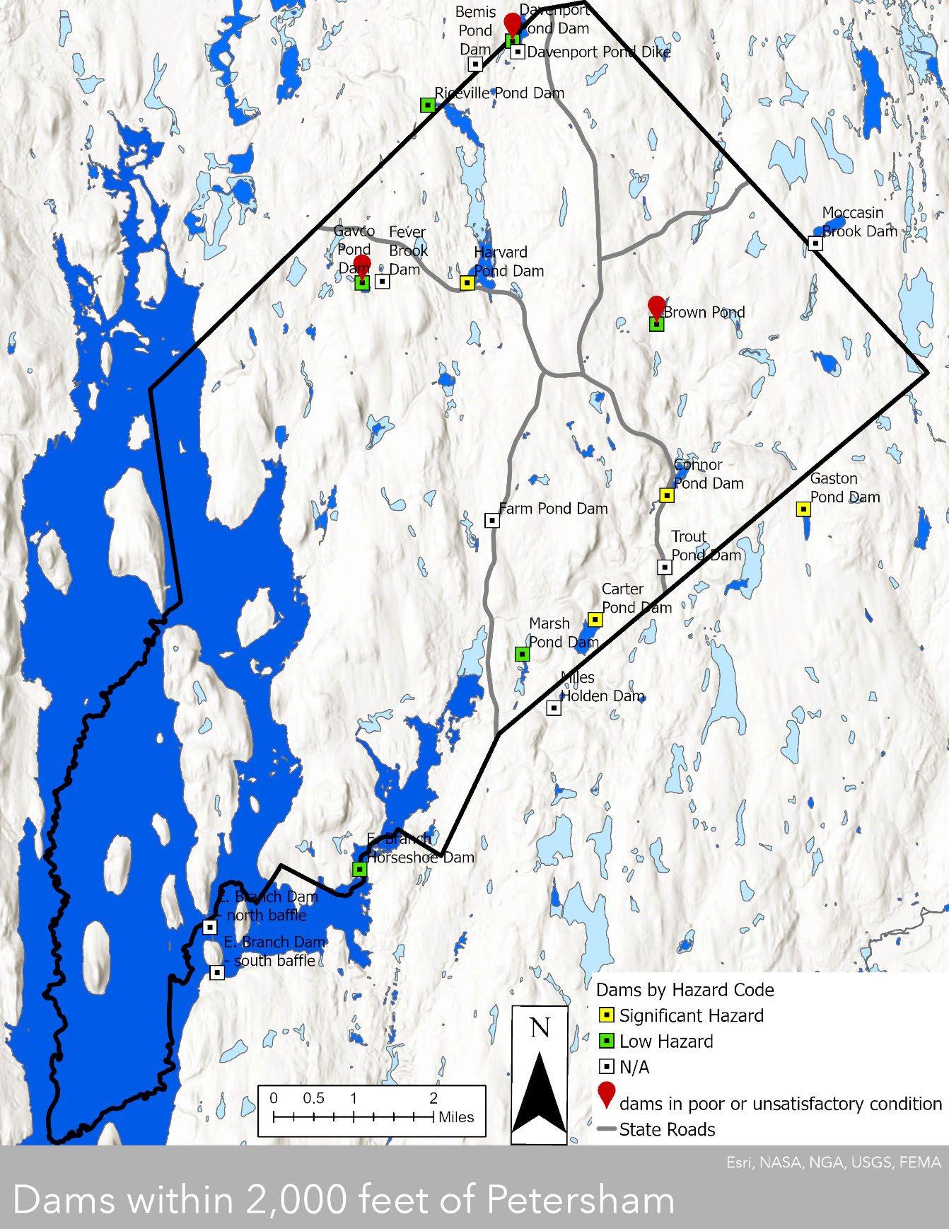
Dam locations within Petersham are shown by hazard code, which indicates the threat level if the dam were to fail.
Dams in poor or unsatisfactory condition have red pins (See Table 3-4: Dam Hazard and Risk Condition). Sources: MassGIS Census Towns, MassDEP Hydrography (1:25,000), Dams
Section 3 Petersham 2024 OSRP pg. 24
Map 3-7: Dams within 2,000 feet of Petersham, MA
Table 3-4: Dam Hazard Risk and Condition
Dams within Petersham
Dam Name Owner Town Regulating Authority Hazard Code Risk Condition Last Inspection
Connor Pond Dam Private Petersham ODS Significant Fair 3/2/17
Brown Pond Private Petersham ODS Low Poor 6/8/09
Carter Pond Dam Private Petersham ODS Significant Satisfactory 11/11/17
Harvard Pond Dam Private Petersham ODS Significant Fair 12/2/13
Gavco Pond Dam Dept. of Fish & Game Petersham ODS Low Unsatisfactory 12/11/09
Farm Pond Dam Private Petersham non/other N/A
Trout Pond Dam Private Petersham non/other N/A
Davenport Pond Dam Town of Petersham Petersham ODS Low Poor 10/8/09
Davenport Pond Dike Town of Petersham Petersham non/other N/A
Fever Brook Dam Private Petersham non/other N/A
Marsh Pond Dam Private Petersham ODS Low Not Listed Not Listed
E. Branch Horseshoe Dam DCR Hardwick ODS Low Fair 8/21/2009 Dams within 2,000 feet of Petersham
Riceville Pond Dam DCR Athol ODS Low Fair 12/7/2010
Gaston Pond Dam Private Barre ODS Significant Fair 4/12/218
Miles Holden Dam Private Barre non/other N/A
Bemis Pond Dam Private Athol non/other N/A
Moccasin Brook Dam Private Phillipston non/other N/A
E. Branch Dam - south
baffle DCR Hardwick non/other N/A
E. Branch Dam - north
baffle DCR Hardwick non/other N/A
Several dams in Petersham which pose a low risk are in poor or unsatisfactory condition and have not been inspected since 2009. Inspections should occur every decade for Low Hazard dams and every 5 years for dams with Significant hazard potential (Mass.gov Dam Safety). National Inventory of Dams conditions rankings are defined as:
Satisfactory – No existing or potential dam safety deficiencies are recognized.
Fair – No existing dam safety deficiencies are recognized for normal loading conditions. Rare or extreme hydrologic and/or seismic events may result in a dam safety deficiency.
Poor – A dam safety deficiency is recognized for loading conditions which may realistically occur. Remedial action is necessary. Poor may also be used when uncertainties exist as to critical analysis parameters which identify a potential dam safety deficiency. Further investigations and studies are necessary.
Unsatisfactory – A dam safety deficiency is recognized that requires immediate or emergency remedial action for problem resolution.
Not Rated – The dam has not been inspected or has been inspected but, for whatever reason, has not been rated. Remediated – The number of state-regulated high hazard potential dams that have been remediated (that is construction has been completed) in the calendar year because of hydraulic/ structural deficiencies. (Association of State Dam Safety Officials).
Section 3 Petersham 2024 OSRP pg. 25
D3. Long-Term Development Patterns
An expanded highway system and faster, safer, more reliable automobiles enabled summer vacationers to travel farther afield and pass by Petersham. But the same transportation changes made commuting easier. Destinations such as Northampton, Springfield, and Worcester are within an hour’s drive (See Map 3.3: Nearby Massachusetts Cities) Boston is only an hour-anda-half away. The average travel time to work for Petersham residents in 2022 was 38 minutes with 77% of the workforce driving alone, 9% carpooling, 5% walking, and 9% working at home. (U.S. Census Bureau). The number of people working from home in metropolitan areas nearly tripled during the height of the COVID-19 pandemic (2019-2021) with nearly a quarter (23.7%) of Massachusetts doing so (U.S. Census Bureau) There is a strong possibility that the number of employees who work remotely or work in a hybrid on-site/remote model will increase. Petersham’s proximity to metropolitan areas coupled with its rural character and recreational potential may make it very attractive as a place to live, which could increase the potential of development in Petersham.
There is a long-term likelihood that populations will move inland as sea level rises and coastal habitation becomes more unstable. Nearly a third of the United States population lives in areas subject to associated flooding, shoreline erosion, and storm hazards (Global Center on Adaptation) As frequency and intensity of these conditions increases, people may move to more stable areas inland. Petersham may seem especially attractive to people who have been dealing with saltwater intrusion into freshwater aquifers because of its proximity to freshwater drinking sources, even though Petersham does not currently draw its drinking water from the Quabbin.
Although the number of residents in Petersham only grew by fourteen since 2000, the number of housing units increased from 474 in 2000 to 558 in 2020, an increase of 84 units or 18% (Petersham Affordable Housing Plan, U.S. Census Bureau). Of those 84 units, 32 were residences built after 2010 (MassGIS Data: Property Tax Parcels). (See Map 3-8: New Homes Built 2000-2023) Petersham has relatively few single-occupant households or second homes in comparison to the state, the county, and its nearby population-peers. Since 14% of housing units are vacant it is not clear why there is such a discrepancy between population growth and new residential development (See Table 3-5: Housing in Petersham). But new development can impact a community’s rural character through its impact on the viewshed and presence of open space.
Section 3 Petersham 2024 OSRP pg. 26
Map 3-8: New Homes Built 2000-2023
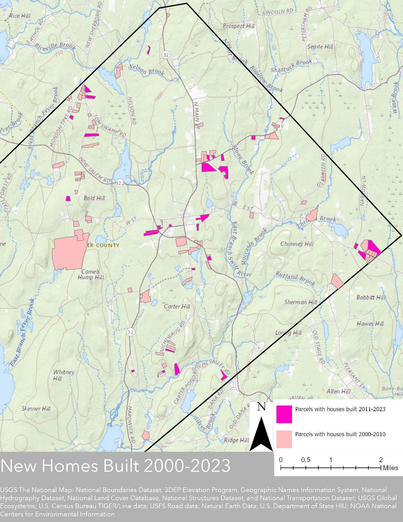
There were 78 new houses built between 2000 and 2010, and another 32 built between 2011 and 2023. The slowdown is likely a combination of after-effects of the 2008 housing bubble and recession and the permit restrictions in the 2010s. Construction is generally within the areas of development potential shown by the build out map. (See Map 3-9: Limited Build Out: Main Roads Only ) This is to be expected since so much of Petersham is otherwise conserved. Sources: MassGIS Census Towns, Property Tax Parcels
Section 3 Petersham 2024 OSRP pg. 27
Table 3-5: Housing in Petersham
Source: U.S. Census Data
While the slow-down in housing starts after 2010 may have been influenced by the housing bubble and recession of 2008, it was also impacted by the Petersham’s Zoning Bylaws Section 20, which was intended to slow residential growth, defined in Section 20 as “building permits issued for new dwelling units.” Permits for residential units were limited to six per calendar year from 2015 through 2020. According to the Petersham Building Inspector’s Annual Reports, the six-permit-limit was never reached while Section 20 was in effect. This was the case before and during the pandemic, so it is unclear if the pandemic had any effect on the number of building permits. In the fiscal year 2020 (July 2020-June 2021) there were only three permits issued. But in fiscal year 2022 there were seventeen building permits issued. While there is some question as to whether these were all for new housing, it is still a marked increase over the prior years. There is a very distinct possibility that there will be more desire for housing development.
Petersham’s Zoning By-Laws, without the permitting limitation of Section 20, will continue to guide that development. The entire town is zoned as a Residential-Agricultural District. Oneand two-family dwellings and many agricultural operations are permitted by right. Businesses
Section 3 Petersham 2024 OSRP pg. 28
MA Worcester County Petersham New Salem Shutesbury Pelham Hardwick Phillipston # % Total population # 7,029,917 862,111 1,194 100% 983 1,717 1,280 2,667 1,726 HOUSEHOLD
TYPE Total households # 2,749,225 331,797 479 100.0% 427 724 544 1,107 674 Living alone % 16.4% 14.6% 51 househ olds 10.6% 14.8% 12.4% 12.3% 13.6% 9.3% HOUSING OCCUPANCY Total housing units # 2,998,537 351,764 558 units 100% 460 853 574 1,242 808 Occupied housing units % 91.7% 94.3% 479 units 85.8% 92.8% 84.9% 94.8% 89.1% 83.4% Vacant housing units % 8.3% 5.7% 79 units 14.2% 7.2% 15.1% 5.2% 10.9% 16.6% For rent % 1.9% 1.6% 0 units 0.0% 1.3% 1.2% 0.3% 3.0% 0.6% Rented, not occupied % 0.3% 0.2% 7 units 1.3% 0.0% 0.4% 0.3% 0.5% 0.0% For sale only % 0.5% 0.6% 8 units 1.4% 0.0% 0.8% 0.7% 1.0% 0.4% Sold, not occupied % 0.3% 0.3% 9 units 1.6% 1.5% 0.0% 1.0% 0.4% 0.1% Seasonal, recreational, occasional % 3.6% 1.0% 26 units 4.7% 2.6% 10.6% 0.7% 2.2% 14.1% All others vacant % 1.7% 2.0% 29 units 5.2% 1.7% 2.2% 2.1% 3.9% 1.4% HOUSING
Occupied housing units # 2,749,225 331,797 479 units 100.0% 427 724 544 1,107 674 Owneroccupied unit % 60.4% 63.8% 414 units 86.4% 88.3% 84.0% 82.0% 70.6% 91.8% Renteroccupied unit % 39.6% 36.2% 65 units 13.6% 11.7% 16.0% 18.0% 29.4% 8.2%
BY
TENURE
and other uses may be allowed by Special Permit. The minimum lot area for a pre-existing frontlot new residence is one-and-a-half acres with a one-hundred-and-fifty-foot frontage minimum. Back lots are allowed with similar lot size minimums. The goal is to prevent housing from emulating an urban or suburban pattern by keeping the houses apart. In circumstances where the lots already meet the minimum frontage and size requirements, homes built along the road may create a suburban effect when viewed from the road.
Subdivisions are covered by Section 19 of the By-Laws with a stated goal “to preserve the Town’s historic rural landscape and existing pattern of low-density housing,” as well as protect environmentally sensitive areas and foster small-scale agriculture and forestry. Among other restrictions is a requirement that 80% of the total project acreage must be put into some form of conservation. There is a formula for determining the maximum number of lots as well as a mechanism for increasing the maximum number of lots by including deed-restricted Affordable Housing or by conserving adjacent frontage land. The backlot and subdivision rules were all passed in 2014.
The Planning Board adopted its Rules and Regulations Governing Scenic Roads in 1977, “for the purpose of providing protection to the environmental, aesthetic and historical values of a town’s roads.” They were intended to safeguard the viewshed, promote tree cover, and require replacement of stone walls along the roads. They do not address the road surface and it has been described by residents as having little by way of enforcement mechanisms.
One means of examining the effects of future development is a build-out map (Map 3-9: Limited Build-Out: Main Roads Only) which shows possible development patterns if development were to occur to the fullest extent of the parameters given. This is a depiction of what hypothetically could occur, not a prediction of what will occur. Some important provisions accompany such a map. This map removes from consideration for development all permanently protected lands. It shows Harvard Forest as a separate-but-also-removed category because of the extreme unlikelihood of Harvard University abandoning the important ecological and educational work there. The Build-out Map considers all Chapter 61 land as potentially available for development because Chapter 61 is a temporary protection. It removes from consideration all parcels which do not have the minimum acreage or frontage on major roads or have already been built on. (Due to a quirk in the data layers used to build this map, the build-out only includes major roads, not smaller side streets i.e., there could be more development on parcels on side roads.) It allows the consideration of just one subdivision into two lots when parcels meet the appropriate zoning requirements. The final result is a randomized placement of potential housing structures on lots where it is permitted by conservation status and basic zoning rules. This is indicative of the general pattern of how and where development might happen but does not give actual structure or parcel locations, nor should it be construed as a recommendation for such. This map does not consider restrictions such as slopes, soil classifications and septic suitability, aquatic (i.e. river, stream, or wetland) protection buffers, the Historic District, the Solar District, scenic roads regulations, lot availability, or any other features which may restrict development. Many of the restrictions not included are merely restrictions and not preclusions: in these cases, development may be extremely unlikely but not impossible. The Build-Out map may prove most useful when viewed in the context of recent actual development (Map 3-8: New Homes Built 2000-2023) to analyze ongoing trends and potential impacts that existing zoning may have on open space.
Section 3 Petersham 2024 OSRP pg. 29
Map 3-9: Limited Build-Out: Main Roads Only
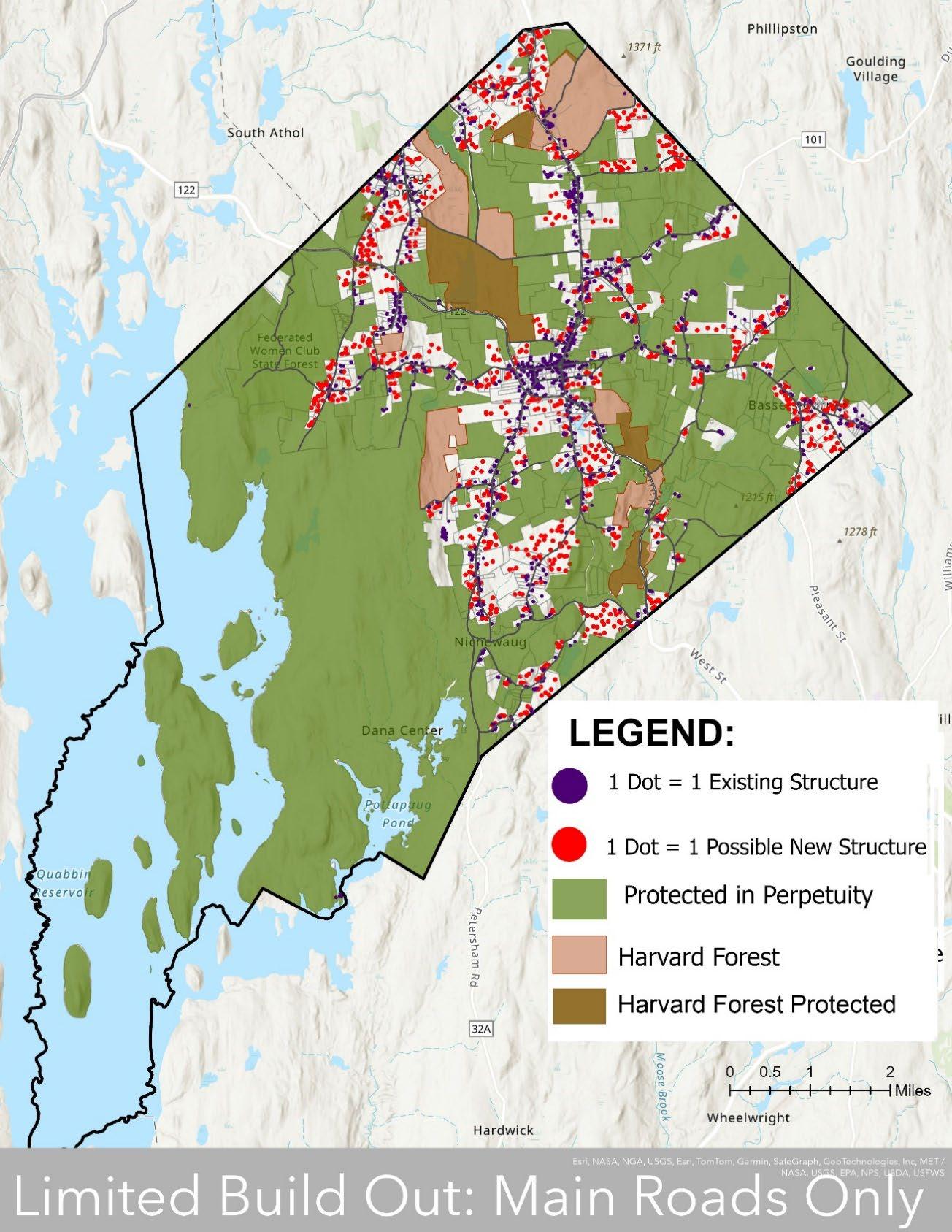
This is a depiction of what hypothetically could occur, not a prediction of what will occur. It considers zoning requirements but does not include many other factors which could restrict development. This map may prove most useful when viewed in the context of recent actual development to analyze ongoing trends and potential impacts that existing zoning may have on open space (See Map 3-8: New Homes Built 2000-202) Sources: MassGIS Census Towns, Property Tax Parcels, Protected and Recreational OpenSpace
Section 3 Petersham 2024 OSRP pg. 30
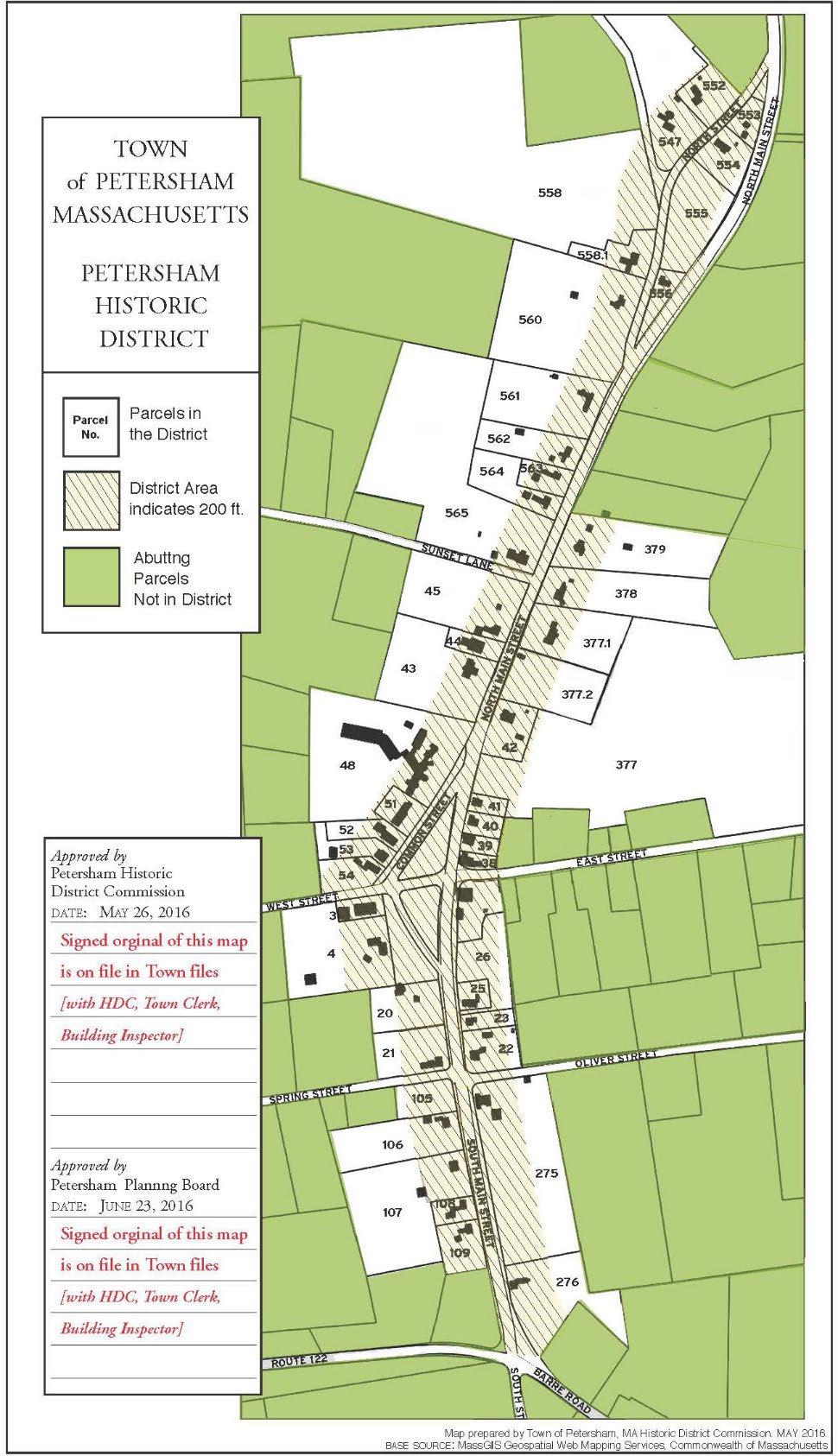
The town center is a Historic District. Any new construction, alterations to construction, or demolition must be approved by the Historic District Commission. This provides a check on creating or filling open space, and this approval was necessary for demolition of the former Nichewaug Inn. The Inn is still shown in lot forty-eight but was demolished in 2022.
Section 3 Petersham 2024 OSRP pg. 31
Map 3-10: Petersham Historic District
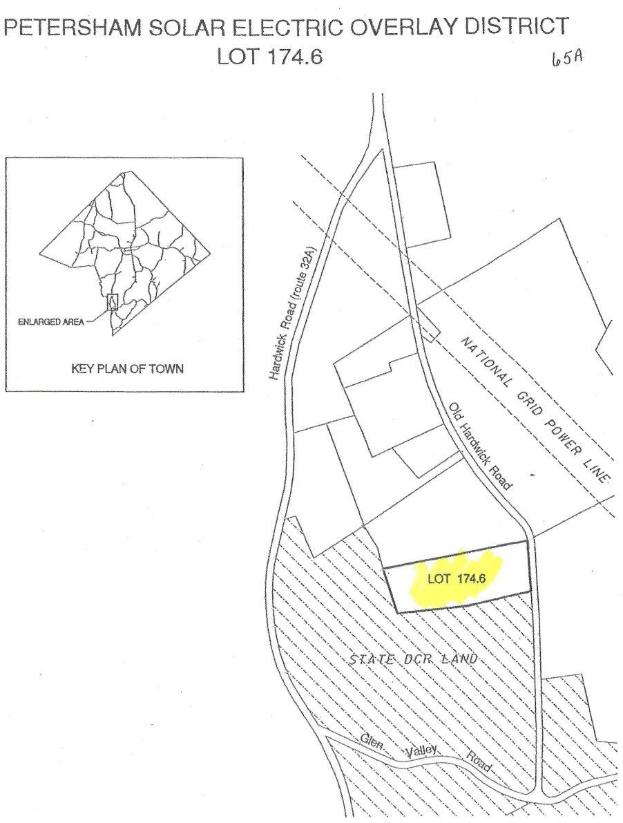
A state-mandated Solar Overlay District includes exactly one parcel (174.6) near the middle of Petersham’s southeast border, between Hardwick Road (Route 32a) and Old Hardwick Road. The parcel is adjacent to state DCR land and located near transmission lines. Building-mounted solar installations are allowed outside of the district with a building permit. Small-scale (10 kilowatts or less) installations are allowed in the district if they adhere to regulations laid out in the zoning code, such as adhering to building code and size and siting requirements. Solar installations with a capacity of more than 10 kilowatts are only allowed within the one-parcel district or elsewhere by special permit. While solar arrays can mitigate climate change by shifting energy use patterns from fossil fuels to renewable energy, ground-mounted systems are typically installed on agricultural land, forest land, or some other form of open space. Petersham successfully defended a lawsuit appealing a denial of a special permit for a large-scale solar installation. The defense was based on state guidelines and Zoning By-laws which discourage clearing woodlands for solar projects (Sunpin v. O’Neil).
Section 3 Petersham 2024 OSRP pg. 32
Map 3-11: Solar District
Section 4
Environmental Inventory and Analysis
Section 4 Petersham 2024 OSRP pg. 33
Beaver pond north of East Street Cemetery, Petersham, Massachusetts
Section 4A. Geology, Soils, and Topography
Petersham can be generally characterized by north-south running ridges and hills, with a general sloping downward as one moves from north to southwest. A central ridge that roughly parallels North Main Street runs from the northern corner of town to the town center. A large stretch of dramatic elevation changes runs northeast to southwest along the Swift River Valley in the southeastern quarter of town. The bedrock underlying the land area of town is largely mafic rock to the east and acidic bedrock types to the west, which is mostly overlain by an unsorted mix of rocky, gravelly, and sandy till that was left behind by glaciers thousands of years ago. While the bedrock determines the overall topography of the landscape, it is this glacial till that shapes most of its soils, and their rocky composition makes them mostly unsuitable for agriculture. However, small pockets of prime agricultural land occur in the center and eastern areas of town.
Topography
Petersham sits towards the center of the hilly, rocky landscape of Central Massachusetts’ Worcester Plateau. It consists primarily of rolling hills interspersed with ponds and rivers, most of which are in the Quabbin Reservoir watershed. In general, the terrain slopes downward as one moves from north to south or northeast to southwest, with elevations ranging from about 1,279 feet in the northern corner of the Town to about 574 feet along the Quabbin Reservoir. A central ridge that roughly parallels North Main Street runs from the Athol border south to the town center, and ranges in elevation from more than 1,200 feet at the Athol border to about 1,080 feet at the town common Most current human settlement and infrastructure is in the uplands along this central ridge.
The southeastern quarter of town features steep terrain with ledges and ravines of the Swift River Valley the largest tributary of the Quabbin reservoir. A network of ridges with long stretches of 15 to 25% grades runs northeast to southwest roughly parallel to the town’s southern boundary line before reaching the lowlands around the Quabbin and what used to be the town center of Dana.
The western portion of Petersham abutting the Quabbin is a couple hundred feet lower in elevation than the northern uplands. Another ridge punctuated by small mountains (Bald Hill, Camel’s Hump Hill) with peak elevations in the 600- to 800-foot range runs from north to south. Former mountains with similar elevations were transformed into islands and peninsulas with the filling of the reservoir.
Petersham’s hilly and rocky landscape has, like much of New England’s uplands, reforested since agriculture moved to the fertile west in the late 1800s. Its upland position relative to the Quabbin-flooded valley meant that it was not only spared by the creation of the reservoir, but its boundary was expanded to the southwest across three disincorporated towns, much of which was acquired by the Department of Conservation and Recreation and put into permanent protection from development. The result is a thickly wooded upland landscape that is a hotspot for outdoor recreation, and some of the most intact forest habitat within the state of Massachusetts.
Section 4 Petersham 2024 OSRP pg. 34
Geology (Bedrock and Surficial Materials)
Underlying the eastern half is mafic rock, which has a higher pH and overall nutrient richness than the western, acidic bedrock found in the western half of town. These acidic bedrocks (granite, sulfidic schists, and pelitic rocks) are typical of Massachusetts uplands, but a few pockets of ultra-mafic bedrock outcroppings contribute greatly to the geologic diversity in town. As bedrock is a major driver of species richness, Petersham’s bedrock diversity contributes to its diversity of wildlife and vegetative species. Mafic bedrock in particular tends to support rare and endemic species. Further discussion of bedrock’s influence on Petersham’s wildlife and vegetation is in sections 4D and 4E.
Section 4 Petersham 2024 OSRP pg. 35
Map 4-1: Soils and Geologic Features – Bedrock
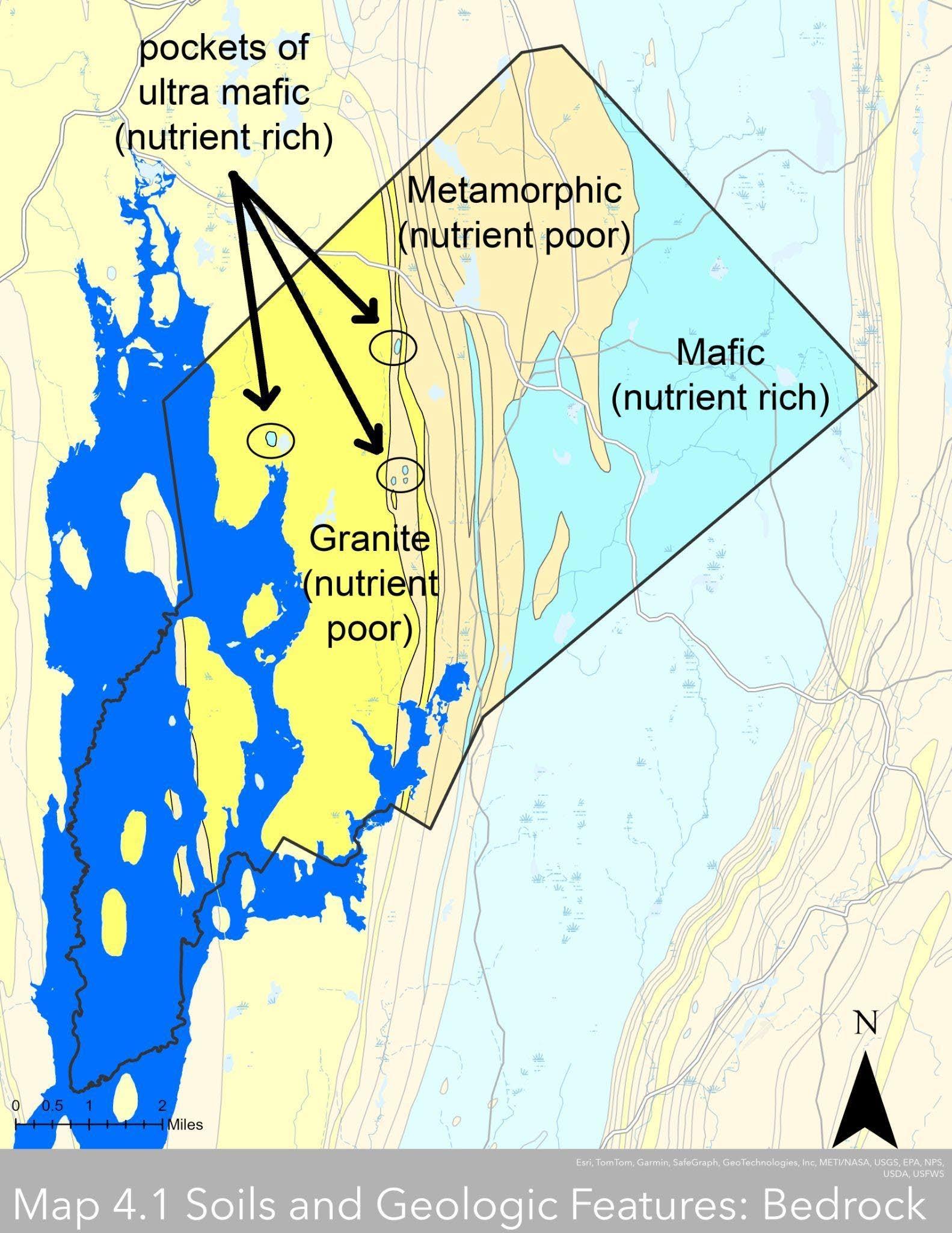
The eastern half of Petersham’s bedrock is mafic rock (blue) that has a slightly higher pH than the acidic granite and metamorphic schists (yellows) to the west. However, a few pockets of higher pH ultra-mafic bedrock occur within the acidic types. This distribution of different bedrock types is one significant influence of the wildlife and vegetation present in Petersham, as discussed in Sections 4D and E
Data source: Mass GIS Data Layers Bedrock Lithology Poly Group B Detailed, Quabbin Reservoir Bathymetry
Section 4 Petersham 2024 OSRP
pg. 36
Surficial materials are the looser materials that sit on top of bedrock and form the base for the soils seen at the surface. Petersham’s surficial materials are distributed in much the same way as they are in the uplands throughout Massachusetts. Sorted glacial deposits of sands and gravel lie in the lowlands between monadnocks and hills. These sand and gravel deposits are relatively well-sorted (meaning that grain size tends to be relatively consistent) and porous and are the most likely places to find productive groundwater aquifers.
Often found near the sand and gravel deposits are narrow bands of silt-rich alluvial deposits along riparian systems, and pockets of highly organic and mucky swamp deposits. These surficial types often produce hydric soils – soils that transmit groundwater poorly and are where wetlands occur in town. Few structures and roads are built on these deposits in Petersham, as most infrastructure and development has taken place on the upland glacial till soil types as noted above, so septic system failure due to poorly draining muck soils is not a major issue in this community.
However, most of Petersham’s bedrock is largely covered with a layer of unsorted material that glaciers picked up and deposited 10,000 years ago – an acidic, granitic jumble of sand, pebbles, gravel, cobbles, and boulders, with a bit of silt and clay, called glacial till. Glacial till is common in the uplands of Massachusetts, and the effects it has on soils and vegetation are well understood: there are few areas fit for growing crops, makes great forestland, is not a typical source of aquifers, and can often limit the functioning of traditional septic systems via restrictive layers.
Soils: Restrictive Features
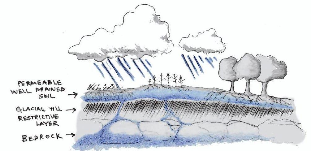
Although glacial till makes for sandy soils that drain well at the surface, it can come with a horizontal “restrictive layer” of dense material. So, while the soil texture at the top may be well drained, with a restrictive layer close enough to the surface, even well drained soils can remain wet long after a rain. Petersham’s surficial material and soils match Massachusetts’ upland geologic pattern – 70% of its land area is covered in glacial till, and just over 60% of it pairs well-draining soil texture with a restrictive layer lying within 60” of the soil’s surface, resulting in soils that hold a lot of water.
Figure 4-1
Petersham’s permeable and welldraining soil sits on a restrictive layer that can hold water within reach of vegetation. Some water percolates through to deeper bedrock layers that private wells access.
Table 4-1: Soils in Petersham
Section 4 Petersham 2024 OSRP pg. 37
Montauk-ScituateCanton association, 3 to 15 percent slopes, extremely stony
Woodbridge-Paxton association, 3 to 15 percent slopes, extremely stony
Charlton-ChatfieldHollis association, 15 to 45 percent slopes, very rocky
Peru-Marlow association, 3 to 15 percent slopes, extremely stony
Montauk-Canton association, 15 to 35 percent slopes, extremely stony
Charlton-Paxton association, 15 to 45 percent slopes, extremely stony
Charlton-Chatfield association, 3 to 15 percent slopes, extremely stony
Catden and Natchaug mucks, 0 to 2 percent slopes
Montauk 17% Well drained Not prime farmland yes
Woodbridge 12% Moderately well drained Not prime farmland yes
Charlton 11%
drained Not prime farmland
10% Moderately well drained Not prime farmland yes
Montauk 7% Well drained Not prime farmland yes
Charlton 6%
drained Not prime farmland
Charlton 5% Well drained Not prime farmland
Catden 4% Very poorly drained Not prime farmland
Ridgebury-Whitman association, 0 to 8 percent slopes, extremely stony Ridgebury 4% Poorly drained Not prime farmland yes
Three of Petersham’s four main soil groups feature restrictive layers within 60” of the soil’s surface. While technically well-draining because of their texture, these soils may remain wet during seasons with heavy rains because the restrictive layer holds water near the surface. Sources: Mass GIS Data Layer SSURGO-Certified NRCS
Section 4 Petersham 2024 OSRP pg. 38 Soil Group Dominant Component % land area (34,688 total acres) Drainage Prime Farmlan d Restrictive layer within 60" of soil surface
Well
Peru
Well
Other 24%
Map 4-2: Soils and Geologic Features – Wet Soils
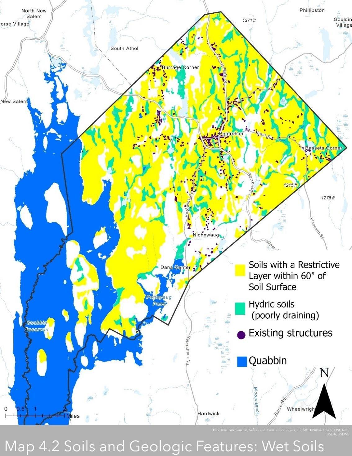
Very little development has occurred on hydric soils (seafoam green), so septic system failure due to poorly draining muck soils is not likely a major concern for this community. However, most of the development is on soils with shallow restrictive layers that can hold water close to the soil surface. In heavy periods of rain these soils may remain saturated long enough to limit the functionality of traditional septic systems and potentially contaminate groundwater. Sources: Mass GIS Data Layers: SSURGO-Certified NRCS, Building Structures (2-D), Quabbin Reservoir Bathymetry
Petersham 2024 OSRP pg. 39
Section 4
Saturated soils can have implications for a range of modern human activity on the landscape, including compaction, erosion, and effects on crops and vegetation. Furthermore, wet soils may more frequently affect human activity in the coming decades given the region’s climate predictions for more severe storms and droughts paired with an overall increase in precipitation.
One side effect of human activity on wet soils is compaction. Heavy machinery such as those used for construction, farming, or forestry operations can compact saturated soils, but even hiking and biking use can damage and erode wet trails, increasing maintenance needs and negatively impacting the health of nearby vegetation via compacted root zones. By elimination of pore spaces between soil particles compaction also negatively impacts the soil’s ability to absorb and infiltrate water, thereby increasing ponding, erosion, runoff, sediment and nutrient accumulation in streams, and an overall decrease in water supply to plants (Bryant 2015). Additionally, compaction, soil saturation, and high winds all increase the risk of blowdowns within a forest (Brodbeck and Rowe 2019) as the severity of storms is already increasing due to climate change.
Implications for vegetation are also mixed. In a heavy season of rain, prime agricultural soils with a densic layer could remain too wet for annual crops to grow well, but under drought conditions the densic layer could keep needed water within reach for annual crops and forests. This ready access to water in droughts increases the region’s resilience to drought (Cates 2020).
Saturated soils can cause traditional private septic and leach field systems to fail, affecting water quality and contributing pollutants to watershed systems. All of Petersham is on private septic and wells. While there is no current evidence that directly points to septic pollution or widespread septic failure, the combination of individual septic systems on soils with restrictive layers in a region that is likely to see an increase in precipitation over the coming decades could become problematic for the community in the future. Not only the quality of the community’s private well water would be affected, but also the Quabbin reservoir could be affected by largescale septic failure.
While the potential for saturated soils does not rule out the use of traditional septic systems in town, alternative systems designed for saturated soils may be better suited. Another approach many neighborhoods take to protect water quality is to site a shared septic system on the most suitable soils in each area, rather than relying on individually installed systems across soils with varying septic suitability.
Section 4 Petersham 2024 OSRP pg. 40
Soils: Prime Farmland
Prime agricultural soils in Petersham are concentrated towards the town center along North Main Street (Route 32) and east of town center along East Street. Colonial settlement of the region occurred primarily along these concentrated areas of prime agricultural land, and many of these early structures remain and are inhabited by Petersham residents today.
“Prime farmland is land that has the best combination of physical and chemical characteristics for producing food, feed, forage, fiber, and oilseed crops and that is available for these uses. It has the combination of soil properties, growing season, and moisture supply needed to produce sustained high yields of crops in an economic manner if it is treated and managed according to acceptable farming methods.”
-USDA Natural Resources Conservation Service
Table 4-2: Prime Agricultural Soils in Petersham
Marlow fine sandy loam, 3 to 8 percent slopes
Merrimac fine sandy loam, 3 to 8 percent slopes
Paxton fine sandy loam, 3 to 8 percent slopes
Peru fine sandy loam, 3 to 8 percent slopes Peru 0.55
Sudbury fine sandy loam, 0 to 3 percent slopes Sudbury 0.36
Woodbridge fine sandy loam, 3 to 8 percent slopes
Woodbridge 0.25
Canton fine sandy loam, 3 to 8 percent slopes Canton 0.04
Merrimac fine sandy loam, 0 to 3 percent slopes Merrimac 0.001
Somewhat excessively drained All areas are prime farmland
drained All areas are prime farmland yes
Moderately well drained
Moderately well drained
All areas are prime farmland yes
All areas are prime farmland
Moderately well drained All areas are prime farmland yes
are prime farmland yes
Somewhat excessively drained
All areas are prime farmland
Prime agricultural soils cover less than 5% of the town’s total land area. Prime soils are a limited resource that requires protection from development to retain its ability to produce food.
Data source: Mass GIS Data Layer SSURGO-Certified NRCS
Section 4 Petersham 2024 OSRP pg. 41
Soil Group Dominant Component % land area (34,688 acres total) Drainage Prime Farmland Restrictive layer within 60" of soil surface
All
Marlow 2 Well drained
areas are prime farmland yes
Merrimac 1
Well
Paxton 0.58
Well drained All areas
The Petersham community is determined to protect local farming operations, with special emphasis on supporting farms producing food for local residents. However, prime agricultural soils, those that the USDA has identified as best for producing food, make up less than 5% of Petersham’s area. A significant portion of the prime agricultural soils in the Eastern Agricultural District are in active agricultural use and are under permanent protection from development, which goes a long way to ensure this precious resource is available for generations to come. A minority is under temporary protection of Chapter 61 enrollment, and an even smaller group has no protection.
However, the Prime Agricultural Soils and Soils of Statewide importance along the adjacent southern half of North Main Street (Route 32) in the town center are some of the most heavily developed lands in town (see Map 4-3). Because of the concentration of development, these prime soils may not be best suited for large-scale agricultural operations, but some areas may be suitable for small-scale food production by homeowners. However, the soils of developed parcels have been disturbed and potentially degraded enough that they may not be suitable for growing food at all, and potential lead contamination around the many historic structures in town center would be an additional barrier.
Section 4 Petersham 2024 OSRP pg. 42

Much of the prime and state important agricultural soil within the Eastern Agricultural district is farmed and protected in perpetuity, ensuring that this limited resource so highly valued by the community remains available for generations to come. However, the prime and state important soils that lie in the town center and northwards along North Main Street are the most densely built areas in town. In developed parcels soil has potentially degraded enough that it may not be suitable for farming anymore. Additionally, the remaining prime and statewide important soils that are used for farming in the town center and along North Main Street are unprotected.
Data source: Mass GIS Data Layers: SSURGO-Certified NRCS, Building Structures (2-D), Protected and Recreational Open Space
Section 4
Petersham 2024 OSRP
pg. 43
Map 4-3: Farmed Prime Soils
Section 4B. Landscape Character
Petersham is distinguished by its vast landscape of forests, which cover almost 90% of the town’s land area. Within this forested matrix, the town’s fields, water bodies, and wetlands provide visual interest and landscape diversity. For example, farms and open fields are visible from North Main Street, East Street, South Street, and Hardwick Road, and other open lands provide a beautiful perspective on the landscape as one travels through the town. Further south, the land slopes down toward the Quabbin Reservoir. Here, the landscape is virtually entirely wooded, and much of the land is under DCR ownership.
Throughout the town, the sense of historic rural character is reinforced by numerous landscape details: the stone walls that parallel the roads and crisscross the forests, the rows of old sugar maples along a country lane, or the nineteenth-century farmhouse with a stone foundation and lilacs out front.
The fingerprint of human activities can be seen throughout the town if one looks closely but is most apparent in the town center. The Petersham Historic District contains the greatest concentration of historic buildings in the town some 45 historic buildings, mostly built in the early nineteenth century. As was the case centuries ago, the town center is still the place where residents gather and is still ringed by forests and fields. Residents still shop at the country store and take in the views across the North Common.
Potential Impact of Development on Landscape Character
Development in accordance with current zoning regulations could impact the scenic character of the community. Continued piecemeal single-family home construction along scenic roads outside of the town center will increasingly obstruct views of stone walls, forests, hay and farm fields, and water bodies. Most lots large enough to be subdivided and developed under the current zoning requirements (Zoning Bylaws Section 4: 1.5-acre lots, 150-foot frontage) are along scenic roads (see Maps 3-8 New Homes Built, 3-9 Limited Buildout, and 4-4 Unique and Scenic Resources).
Subdivisions with large lot sizes would also change the scenic character, although these are unlikely to occur because of the strict subdivision zoning bylaws put in place to prevent them (Zoning Bylaws Section 19).
Possible development at the Nichewaug site in the town center could impact the historic character of the area if form is not adequately considered in site planning of projects in the town center. Projects proposed in the Town Center Historic District are subject to review by the Historic District Commission. Petersham’s bylaws allow the commission to regulate exteriors that are visible from the road, but the Town may want to explore further measures to guide development appropriately.
Development could also impact access to public open space for recreation use in town. The lots large enough to be subdivided and developed under the current zoning requirements (Zoning Bylaws Section 4: 1.5-acre lots, 150-foot frontage) are generally distributed along scenic roads outside the center of town. Continued piecemeal 1.5-acre lot construction along scenic roads
Section 4 Petersham 2024 OSRP pg. 44
outside of the town center could reduce access to both official and unofficial public trails that hikers access along these roads. In addition, the expressed desire of many residents to connect existing trails may become more difficult as more private lots are developed between the protected lands harboring trails. Many Petersham residents and visitors enjoy nature-based recreation activities like bird watching, hunting, and fishing. As more 1.5-acre lots are created along back roads, fragmentation of habitat along roads will further increase, and could have a negative impact on the wildlife populations that these recreational activities depend on.
Mapped Scenic Features in Petersham (see Scenic Features Map on following page)
1. Davenport Property
2. Harvard Forest
3. Petersham State Forest
4. Agricultural fields along North Main Street (Route 32)
5. Harvard Forest
6. North Common Meadow
7. Petersham Historic District and Country Store
8. Eastern Agricultural District
9. Brooks Woodland Preserve
10. Connor’s Pond, Rutland Brook Wildlife Sanctuary, Slab City Tract
11. Swift River Reservation, Slab City Tract
12. Babbit Wildlife Sanctuary
13. Nichewaug Village, DCR Quabbin Gate 40
14. Dana Town Common
15. Quabbin Reservoir Fishing Area 3
16. Camels Hump Hill
17. Federated Women’s Club State Forest
18. The Gorge Outlook at Soapstone Hill
Section 4 Petersham 2024 OSRP pg. 45
Map 4-4: Unique Features Map
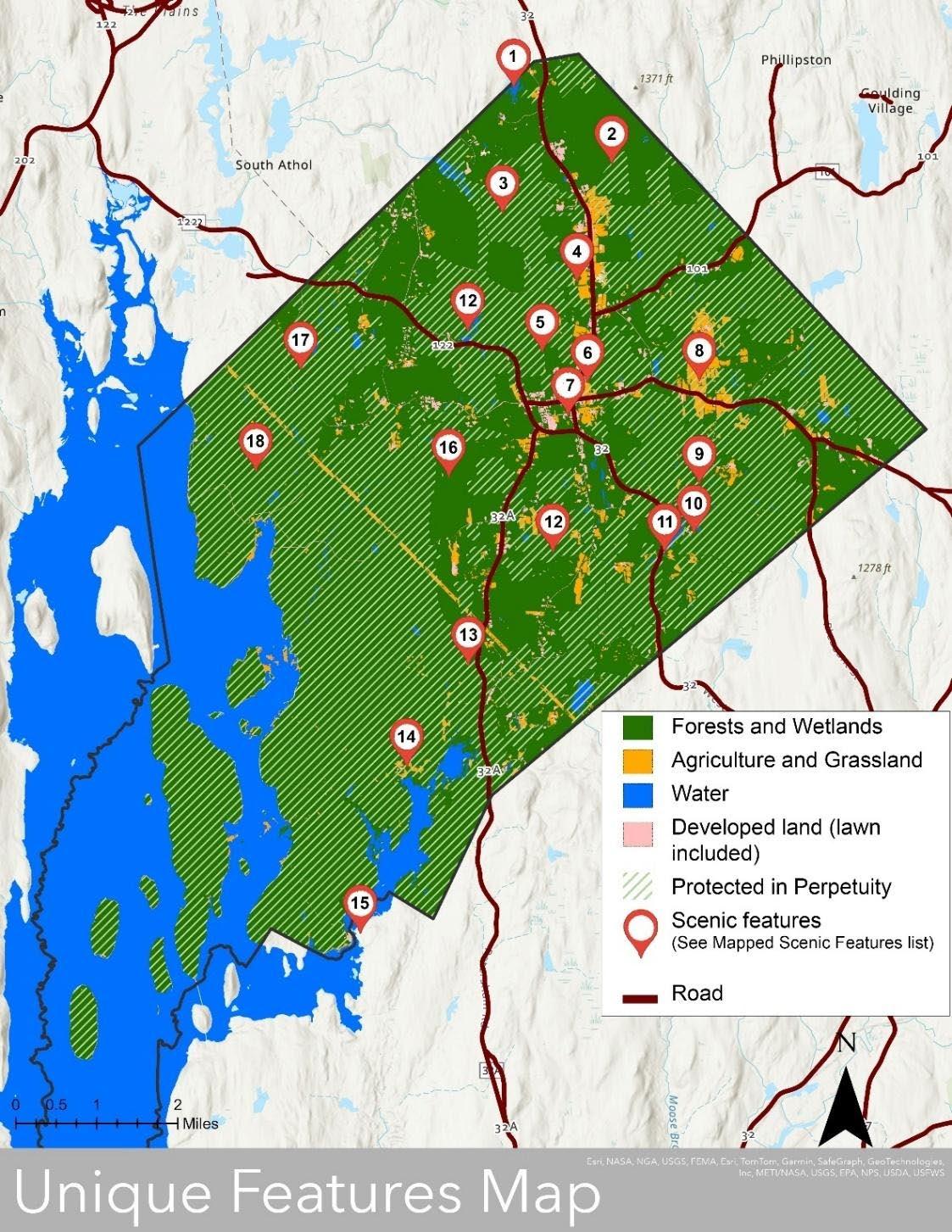
Over 90% of Petersham’s landcover is forested and many main roads are lined with agricultural land. These two characteristics give the main routes in town a notably scenic, wild, and rural feel in addition to the many scenic points of interest lying off the roads. Notably scenic main routes include gently sloped hayfields, croplands, and stone walls along the Eastern Agricultural district (Scenic feature #8) and North Main Street (#4), the forests and wetlands along Route 122 (#12), and the forested slopes on Route 32 heading southward to the Swift River (#11). Although many of the open spaces along these scenic routes are under protection in perpetuity, development in unprotected parcels could significantly impact the town’s beloved rural and scenic character (see Maps 3-8 New Homes Built, 3-9 Limited Buildout). Sources: Mass GIS Data Layer SSURGO-Certified NRCS, Building Structures (2-D), and Protected and Recreational Open Space, Land Cover Land Use (2016), MASSDOT Roads, Quabbin Reservoir Bathymetry
2024 OSRP pg. 46
Section 4 Petersham
Section 4C Water Resources
Watersheds
Major Basins (Hydrologic Unit Code 8)
Most of Petersham is located within the Chicopee River Subbasin, and a small area in the north is within the Millers River Subbasin. The Chicopee River Subbasin drains more than 720 square miles of central Massachusetts before emptying into the Connecticut River in Chicopee. As such, the Chicopee River Watershed is the largest drainage basin in Massachusetts, the largest tributary to the entire Connecticut River, and includes within its bounds the Quabbin Reservoir. This reservoir was named after the Native American chief “Nani-Quaben,” whose name translates as “place of many waters.” (SWAP).
Watersheds and Sub-watersheds (Hydrologic Unit Codes 10 and 12)
Petersham’s share of the Chicopee River Subbasin is nearly entirely within the Swift River Watershed. This watershed includes three sub-watersheds: the Quabbin Reservoir-east part to tip of Prescott Peninsula to the west (West Branch of Fever Brook), the East Branch Fever Brook in the middle, and in the east the East Branch Swift River-headwaters to the Quabbin Reservoir. As all three sub-watersheds drain directly into the Quabbin Reservoir, these brooks and streams directly impact drinking water quality for 3 million people. As such, much of Petersham’s patterns of development and use and access of open space are shaped by the regulations and policies that protect this water supply.
A tiny portion of Petersham is part of the Ware River Watershed at the easternmost corner of town, and a sliver of the southeast-facing boundary line. These watershed areas, like the Miller Basin area to the north, do not drain into the Quabbin and so are not under the same regulations as the Quabbin draining water bodies are.
Table 4-3: Watersheds
Major Basin Watershed Sub-Watershed Quabbin relationship
Miller Basin Lower Miller’s River West Brook to Orcutt Brook
Does not drain into Quabbin, directly or indirectly
Quabbin Reservoir-east part to tip of Prescott Peninsula Drains directly into Quabbin
Swift River
Chicopee Basin
East Branch Fever Brook Drains directly into Quabbin
East Branch Swift RiverHeadwaters to Quabbin Reservoir Drains directly into Quabbin
Ware River Prince River
Ware River-Barre Falls Dam to Danforth Brook
Data sources: Mass GIS Data Layer NRCS HUC 12, 2014 OSRP
Does not drain into Quabbin, directly or indirectly
Does not drain into Quabbin, directly or indirectly
Section 4 Petersham 2024 OSRP pg. 47
Map 4-5: Water Resources Map Watersheds
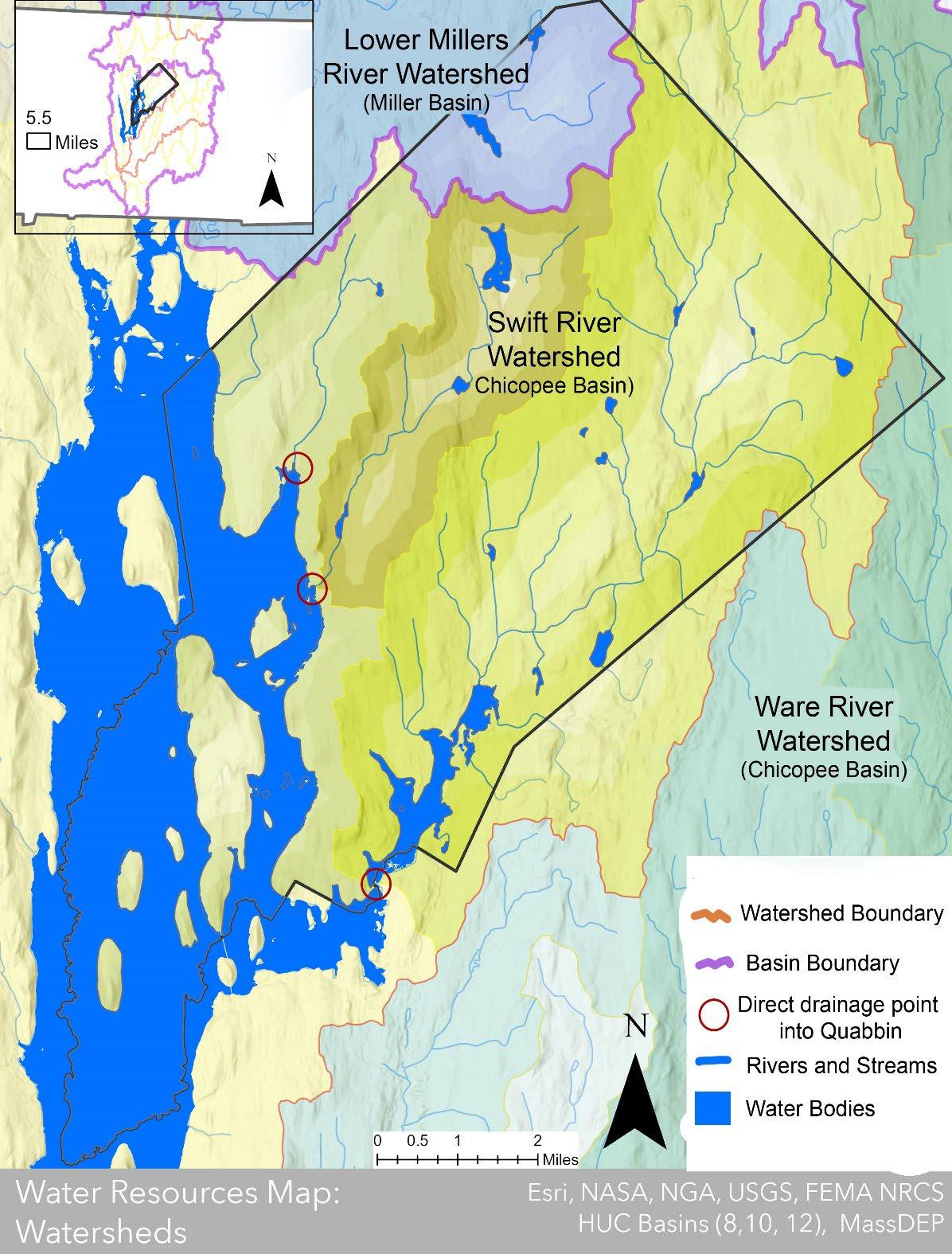
Although a small northern corner of the town is part of the Millers Watershed to the northwest, most of Petersham’s watershed drains directly into the Quabbin Reservoir in the southwest and lies within the Chicopee watershed. As all three sub-watersheds drain directly into the Quabbin Reservoir, these brooks and streams directly impact drinking water quality for 3 million people. As such, much of Petersham’s patterns of development and use and public recreational access and use of open space are shaped by the regulations and policies that protect this water supply.
Sources: Mass GIS Data Layers NRCS HUC 12, Quabbin Reservoir Bathymetry
Section 4
Petersham 2024 OSRP
pg. 48
Water Protection
The state does not test Petersham’s water quality because all its residents are on private well supply, but instead relies on residents to regularly test their own water. However, Petersham’s watershed is a major contributor to the Quabbin Reservoir–the largest public man-made drinking water supply in the world (Massachusetts Water Resources Authority) which is monitored by the Massachusetts Surface Water Assessment and Protection program (SWAP). The Quabbin’s SWAP report is combined with those of the Ware River and Wachusset Reservoir and was most recently conducted in 2002. So, it is unclear how much Petersham’s watershed is contributing to the potential contaminants listed in the report, or how they have changed in the last twenty years. Listed contaminants include microbes from aquatic and non-aquatic wildlife, overuse of fertilizer or pesticides in agriculture, chemical runoff from roads, improper use of pesticides in utility line areas, and private residential land uses such as pollutants from septic systems, lawn care, and household hazardous waste.
The Massachusetts Department of Conservation & Recreation Water Supply Protection Division (DCR DWM) owns and manages a large, protected parcel adjacent to the reservoir to protect the water supply from contamination. The DCR also works with private landowners and local authorities to minimize the risk of watershed contamination elsewhere in town through the placement of watershed protection conservation easements (WPRs), direct purchase of property, assistance with the town’s development of bylaws, and educational programs for visitors and residents, among other management strategies (Massachusetts Department of Environmental Protection). The East Quabbin Land Trust and the Mount Grace Land Conservation Trust are also involved in protecting Petersham's watershed resources.
In addition, the state has placed various levels of restrictive regulations on development and recreation within the Quabbin Watershed to limit potential sources of pollution. These regulations are in addition to statewide regulations pertaining to rivers and stream corridors and wetlands (see Sections 4C Surface Waters and 4C Wetlands).
Massachusetts Watershed Protection Act
The Watershed Protection Act (WsPA), otherwise known as the Cohen Act, is administered by the DCR Office of Watershed Management. It regulates land use and activities within the public water supply areas of the Quabbin Reservoir, Ware River, and Wachusett Reservoir watersheds for the purpose of protecting the quality of drinking water (350 MCR 11.04). Residents can use the DCR online viewer to see how these restriction zones intersect with individual parcels (see Figure 4-1).
The WsPA defines two different resource areas, each of which has a different level of protection. DCR has an online viewer of the geographic delineations of these resource areas (see Figure 4-1, also see Figure 4-2 in the 2005 Master Plan). Within the Primary Zone land within 400 feet of the Quabbin or Wachusett reservoirs or within 200 feet of tributaries and surface waters that drain to these reservoirs any alteration of land or water resources is prohibited. “Alteration” includes a variety of activities, such as construction, excavation, grading, paving, and dumping. Generation, storage, disposal, or discharge of pollutants is also prohibited in the Primary Zone.
Section 4 Petersham 2024 OSRP pg. 49
Within the Secondary Zone between 200 and 400 feet of tributaries and surface waters, on land within floodplains, over some aquifers, and within bordering vegetated wetlands certain activities are specifically prohibited. These include the storage, disposal, or use of toxic, hazardous, and certain other materials; alteration of bordering vegetated wetlands; and other activities. The density of development in the Secondary Zone is limited by a requirement that no more than 220 gallons per day of wastewater per acre may be discharged by the development. For residential development, this is the equivalent of two bedrooms per acre. In addition, development may not render impervious more than 10% of the lot or 2,500 square feet, whichever is greater.
While these protections appear to be quite strong, the WsPA regulations contain a few key exceptions. The most notable of these is that the owner of any lot pre-existing at the time the regulation was enacted (1992) is generally allowed to build a single dwelling unit on that lot, providing that other zoning, health, and environmental standards can be met. A pre-existing owner-occupied parcel may also be subdivided to create one additional building lot. Minor changes to existing structures are also exempt from the regulations. While these exceptions do not allow for the large-scale subdivision of land to accommodate new development, they do allow some development within sensitive watershed protection areas.
A complete list of the recreational restrictions within the various Quabbin Watershed areas is available in the 2018 Quabbin Reservoir Watershed System Public Access Management Plan Update (Appendix F). Among other recreational restrictions, there is no swimming allowed within the Quabbin or its regulating ponds (see Figure 4-2).
Surface Water Supply Protection Zones
Surface Water Supply Protection Zones are established under the Massachusetts Drinking Water Regulations (310 CMR 22.00) to protect active and emergency surface water supplies across the state. Three protection zones are defined in the regulations: Zone A, Zone B, and Zone C (see Map 4-7). Zone A includes land between the surface water source and the upper boundary of the bank; land within 400 feet of the upper boundary of the bank of a Class A surface water source (such as the Quabbin Reservoir); and land within 200 feet of the upper boundary of the bank of a tributary to the water source. Zone B generally includes land within one-half mile of the water source that is also within the source’s watershed. Zone C includes all land within the watershed of a Class A surface water source other than those lands designated as Zone A or Zone B.
To protect surface water sources, the Drinking Water Regulations prohibit potentially hazardous land uses within Zone A, such as underground storage tanks, storage of liquid hazardous materials, and sewage treatment or disposal works. In general, the Watershed Protection Act tends to supersede the Drinking Water Regulations with stricter land use controls within critical Zone A areas.
Section 4 Petersham 2024 OSRP pg. 50
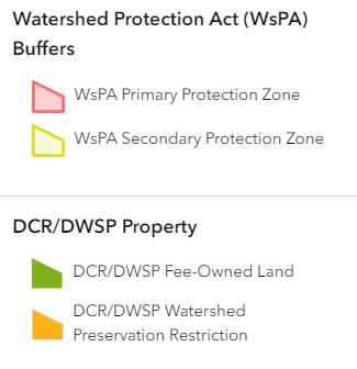
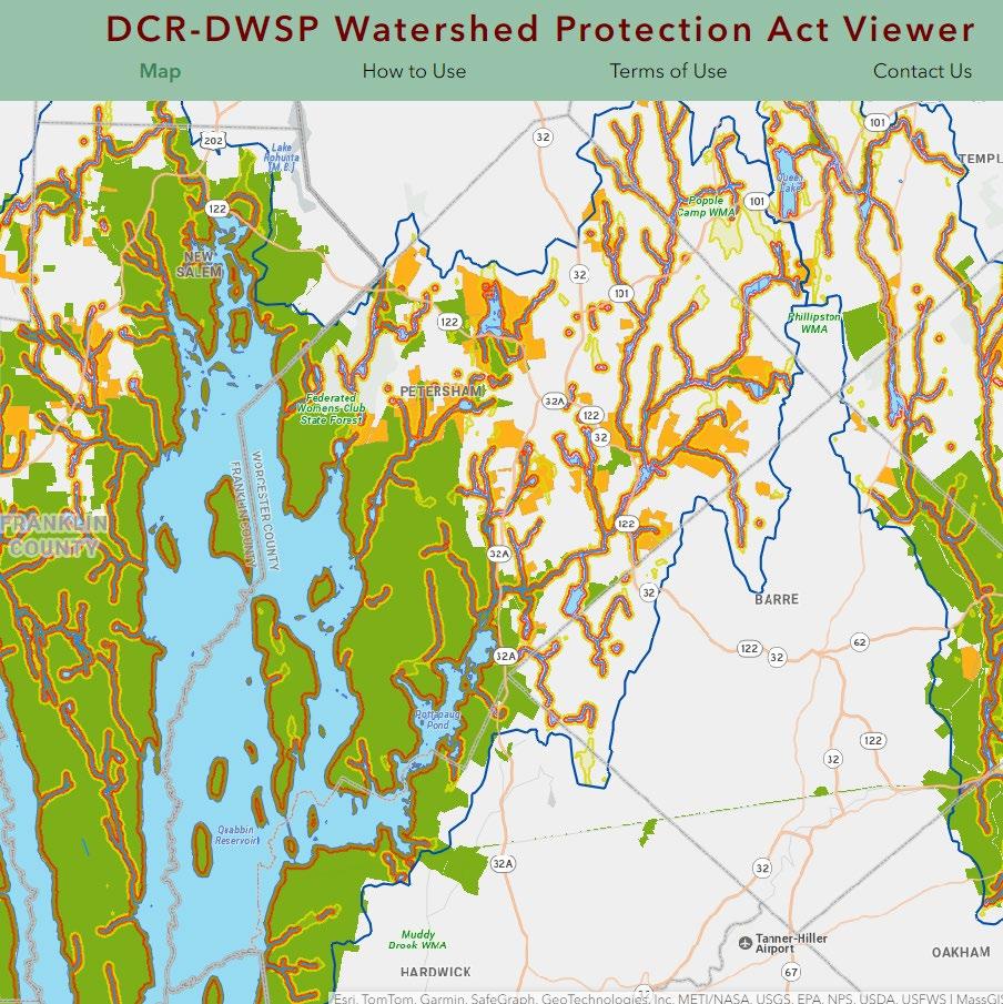
Screen shot of the DCR’s online Watershed Protection Act Viewer that residents can use to access Watershed Protection Act (WsPA) restrictions at the parcel level. These data layers are unavailable for download. The Watershed Protection Act tends to supersede the Surface Water Supply Protection Zones (see following Map 4-6) with stricter land use controls within the critical Zone A areas. Sources: Massachusetts Department of Conservation and Recreation
Section 4
OSRP pg. 51
Petersham 2024
Figure 4-1: Watershed Protection Act Viewer
Figure 4-2:
Reservoir Public Management Areas
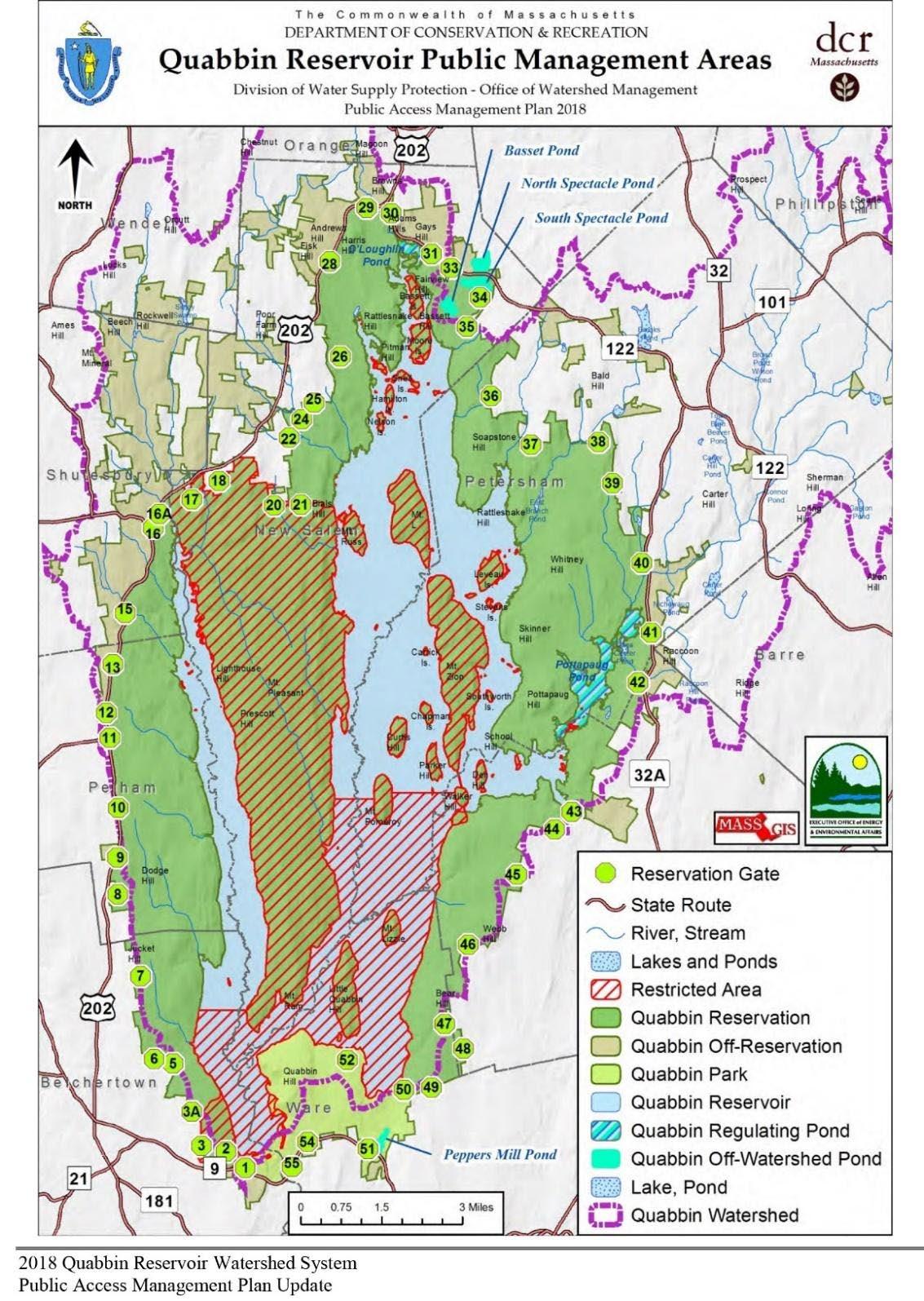
“Water, water, everywhere, and not a place to swim.” -Petersham Resident. Over 70% of the Quabbin watershed is directly owned and managed by the DCR Division of Water Supply Protection which includes a large section of Petersham. Multiple defined areas have different recreational access restrictions and bans swimming within the reservoir and its regulating ponds. To see the full accompanying list of access restrictions, please see the full report in Appendix F. Sources: 2018 Quabbin Reservoir Watershed System Public Access Management Plan Update.
Section 4
Petersham 2024 OSRP
pg. 52
Quabbin
Map 4-6:
Regulated Surface Water Supply Protection Zones
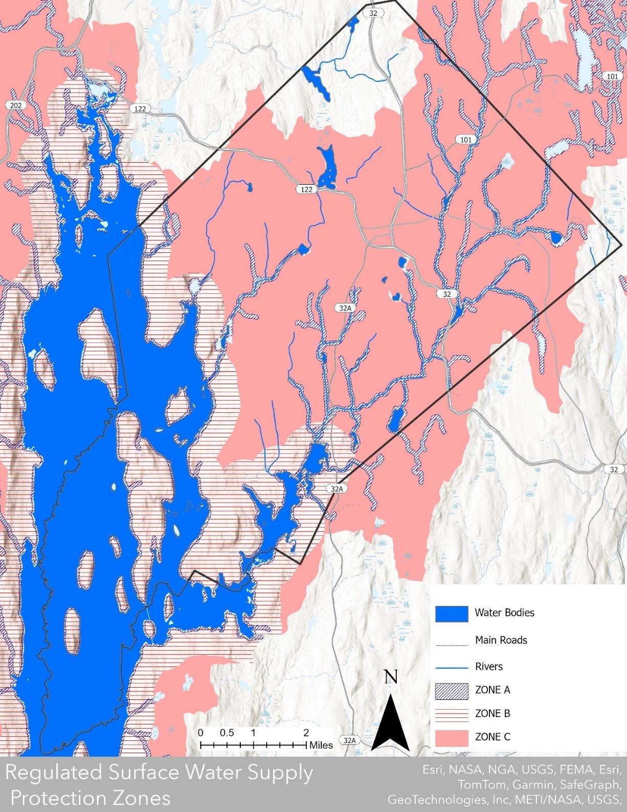
Surface Water Supply Protection Zones are established under the Massachusetts Drinking Water Regulations (310 CMR 22.00) to protect active and emergency surface water supplies across the state. In general, the Watershed Protection Act tends to supersede the Drinking Water Regulations with stricter land use controls within critical Zone A areas (see previous Figure 4-1). Sources: MassGIS Data Layers: Surface Water Supply Protection Areas (ZONE A, B, C), Quabbin Reservoir Bathymetry
OSRP pg. 53
Section 4 Petersham 2024
PFAS
Petersham’s residents are all on private wells, so the town does not have a SWAP report to describe possible contaminants to the water supply. However, because the Quabbin reservoir is partly within the town’s boundaries, Petersham was selected for testing of the Massachusetts Water Resources Authority’s (MWRA) study of per- and polyfluoroalkyl substances (PFAS) across the state’s public water supplies. Six PFAS compounds have been regulated by the state since 2020 because they have been implicated in adverse health effects.
The level of these PFAS compounds found in the town’s tested private wells has exceeded the state’s regulatory standard (Sierra Club). However, according to the same analysis, the Quabbin reservoir’s levels are below the reporting limit.
Although the full picture of how these substances affect humans is not yet clear, studies have shown that they may cause a range of health effects, including thyroid, liver, kidney, immune system, and developmental effects, as well as higher risk of cancer (Andrews et al.). Ecological impacts of these chemicals also remain unclear, but there is a growing body of evidence to suggest that the wildlife health is harmed, which may be most concerning for rare and endangered species that are already struggling with multiple adverse environmental conditions for survival (Andrews et al.).
PFAS chemicals are found in firefighting foam, landfills, manufacturing sites, and likely because of their use in many consumer products, in septic tanks. From these sources PFAS pollutants leach into the ground water supply. It is unclear where Petersham’s PFAS contaminants are from or how they fluctuate over time but given their known impact on public health and the town’s significant watershed contribution into the Quabbin reservoir, the continued monitoring of pollutant levels may be important for the health of local residents relying on private wells and people elsewhere in the state who get water from the Quabbin. Additionally, some of Petersham’s high quality habitat for rare wildlife (see Section 4.D) could face degradation by the presence of PFAS in the watershed.
Surface Water
The water resources within each sub-watershed, including streams, ponds, and wetlands, are identified below. Each water body is matched to a number on Map 4-7 FEMA Flood Zones and Water Bodies.
● The Quabbin Reservoir (#1) was created in the 1930s by the construction of two huge earthen dams. The reservoir is fed by the three branches of the Swift River, and seasonally by the Ware River. To make way for the reservoir, four former towns in the Swift River Valley were evacuated, bulldozed, or burned, and then flooded. The reservoir is 18 miles long and has 181 miles of shoreline including 61 miles along the reservoir’s 60 islands and holds up to 412 billion gallons of water when full. Water from the Quabbin is conveyed eastward to the Wachusett Reservoir to supply communities in the Boston Metropolitan area.
● The East Branch of the Swift River (#2) starts at the confluence of Bigelow, Popple Camp, and Shattuck Brooks in Popple Camp State Wildlife Management Area close to Petersham’s northeastern border with Phillipston. The East Branch of the Swift River is
Section 4 Petersham 2024 OSRP pg. 54
fed by Stony Brook from the west before it flows through Brown’s Pond (#3), joins with Moccasin Brook (#4) from the east and then into Connor’s Pond (#5) where it meets with the waters of Rutland Brook (#6). After the river leaves Connor’s Pond, it is fed by several smaller brooks before joining Pottapaug Pond (#7) and the Quabbin Reservoir.
● The East Branch of Fever Brook (#8) begins at Harvard Pond (#9) and flows southwest toward its mouth at the Quabbin Reservoir southeast of Rattlesnake Hill through the East Branch Pond (#10).
● The West Branch of Fever Brook (#11) flows through the Federated Women’s Club State Forest before draining into the Quabbin just south of Soap Stone Hill.
● Nelson Brook (#12), Davenport Pond (#13), and Riceville Pond (#14) are in the northern corner of town and drain north into the Millers River watershed.
Rivers Protection Act
The area within 200 feet of the riverbank can play an important ecological role by filtering sediment and pollutants out of runoff before it reaches the river; serving as the hydrologic recharge area for rivers; providing complementary habitat for riparian species requiring upland resources; and allowing riparian corridors to serve as wildlife migration routes. The Massachusetts Rivers Protection Act, incorporated into the Wetlands Protection Act in 1996, regulates development within 200 feet of perennial rivers and streams (defined provisionally as those streams that appear as dark blue lines on USGS topographic maps). The Petersham Conservation Commission administers this Act locally. Typically, development is allowed within 100 feet of streams only under extraordinary circumstances, but certain types of development are sometimes allowed between 100 and 200 feet of streams.
Aquifer Recharge Areas
Petersham does not have any high-yield or medium-yield aquifers mapped by MassGIS. Generally, high-yield aquifers are those capable of sustaining a pumping rate of more than 300 gallons per minute (gpm), while medium-yield aquifers can sustain a pumping rate of between 100 and 300 gpm. Smaller, less productive aquifers of alluvial and glacial origin, as mapped by the USGS, are located primarily in the riparian areas along the East Branch of the Swift River and around the Quabbin. Many of the town’s residents obtain their water from deeper wells, which tap layers of rock that are generally poorly permeable but adequate to support the relatively low water needs of single-family houses and small businesses. The lack of medium or high-yield aquifers and community dependence on wells limits the level of development feasible within the town.
Flood Hazard
Flood hazard areas shown in the FEMA Flood Data Q3 Flood Zones data layer are minimal. They occur along ponds, streams, and the East Branch Swift River with little to no development in them (see Map 4-7). The failure of beaver dams during sudden storm events causes temporary flooding (2014 OSRP).
Section 4 Petersham 2024 OSRP pg. 55
Map 4-7: Water Resources Map: FEMA Q3 Flood Zones and Water Bodies
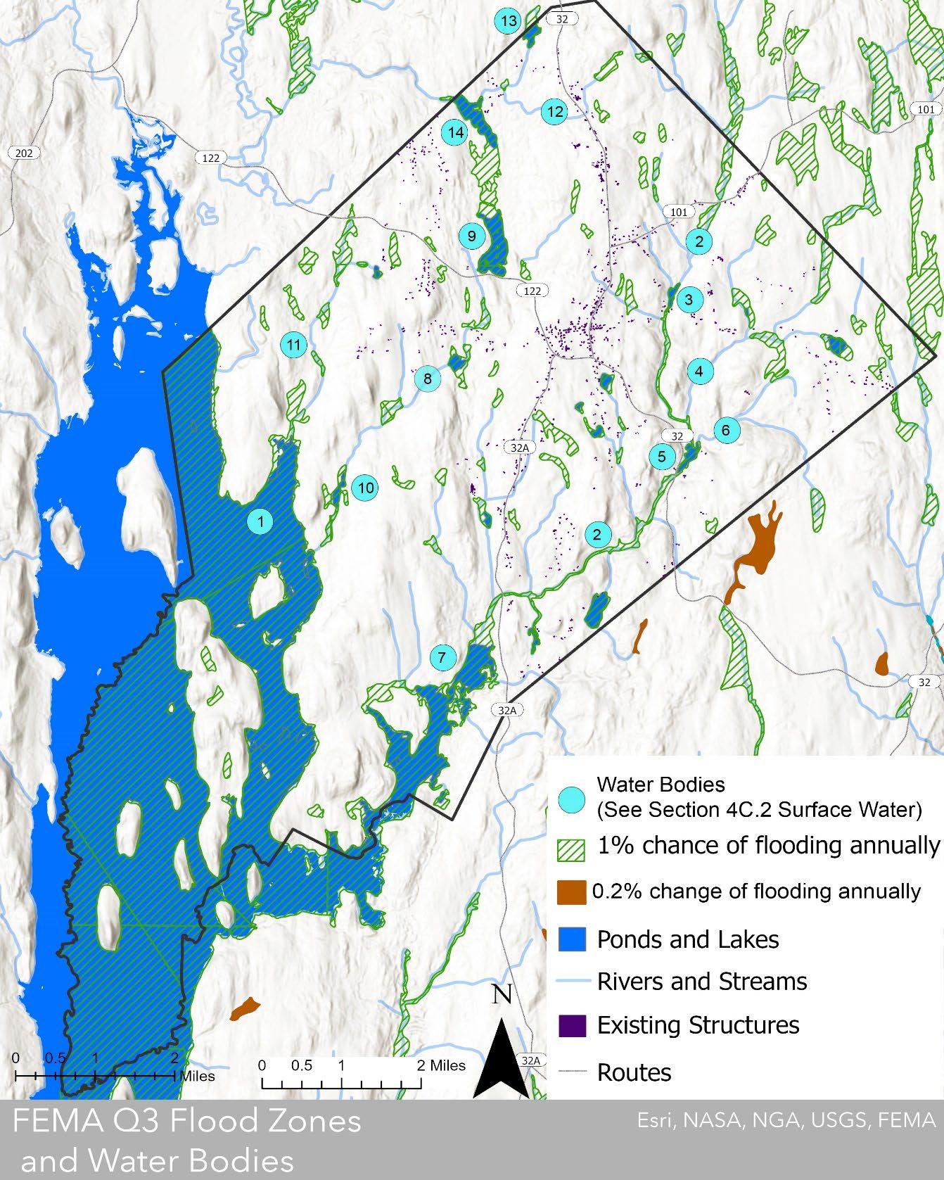
Flood hazard areas are minimal and are shown in the FEMA Flood Data Q3 Flood Zones data layer and occur along ponds, streams, and the East Branch Swift River. These flood zones do not appear to coincide with any existing structures in town. Sources: MassGIS Data Layers: FEMA Q3 Flood Zones, Hydrography 100k, Quabbin Reservoir Bathymetry
Section 4 Petersham 2024 OSRP pg. 56
Wetlands
Unforested wetlands only cover 4% of the town’s land area. Some of the most prominent wetlands are Tom Swamp and the wetlands along the East Branch of the Swift River, which fan out into a wide expanse on both sides of Popple Camp Road (Route 101) as one heads toward Phillipston. According to the 2014 OSRP, as with other parts of the town, there is considerable beaver activity in Harvard Pond bordering Tom Swamp on the south and numerous beaver ponds along the East Branch of the Swift River. Other riparian wetlands border portions of several streams and ponds in Petersham, including Harvard Pond, Riceville Pond, Pottapaug Pond, and all three major streams. Petersham does not have an official wetlands map. Numerous riparian connected wetlands evolve as the beaver population continues to develop (2014 OSRP).
Many of Petersham’s wetlands are under permanent protection from development, while some areas have limited protection from development via the Massachusetts Endangered Species Act (MESA). Three of Petersham’s largest wetlands, while somewhat protected under the ownership and care of Harvard Forest, have partial to limited levels of official protection (see Map 4-8).
Climate Change
Wetlands are a critical tool for climate change mitigation. Although only 3% of the world’s surface is wetlands, they store 30 to 50% of the world’s carbon, which is twice as much global forests (UN Environment). When wetlands are drained for development, stored carbon is released into the atmosphere. Additionally, Petersham’s wetlands harbor rich biodiversity as they include numerous rare and endangered species (see Section 4E), making them a critical landscape for the community’s mitigation and adaptation of climate change (United Nations).
Legal Protection
Wetlands have both human and ecological importance for pollution control, flood control, storm damage protection, wildlife habitat, fisheries, groundwater supply, and recreation. Wetlands in Massachusetts are regulated under the Wetlands Protection Act (310 CMR 10.00). Petersham’s Conservation Commission is currently developing a local wetland protection bylaw to supplement these state regulations.
Vernal pools are not protected by the Wetlands Protection Act by right; however, vernal pools certified by the Massachusetts Natural Heritage and Endangered Species program are protected (see Map 4-8). These certified vernal pools are also protected by the state Water Quality Certification regulations (401 Program), the state Title 5 regulations, and Forest Cutting Practices Act regulations. Many of Petersham’s potential vernal pools mapped by the NHESP are not certified and not under permanent protection.
The Massachusetts Wetlands Protection Act applies to activity within 100 feet of bordering wetlands (wetlands bordering ponds, streams, and other water features) and within certain isolated wetlands. The Wetlands Protection Act does not provide protection for many small, isolated wetlands.
The Petersham Conservation Commission administers this law and considers applications for activities in wetlands and buffer zones. According to the 2014 OSRP, wetland alteration is generally only allowed when there are no feasible alternatives and is subject to the condition that
Section 4 Petersham 2024 OSRP pg. 57
an equivalent amount of wetland must be replicated elsewhere. However, there is a growing body of evidence that suggests that wetland replication projects have variable establishment success rates and that constructed wetlands may take decades to centuries to have a net positive effect in mitigating climate change because of the methane released from their construction (Regenerative Design Group, et al., 51).
In wetland buffer zones, work is often allowed subject to an Order of Conditions from the Conservation Commission. Although the Conservation Commission has some discretion in deciding how much development to allow in wetlands and buffer zones, the MA Department of Environmental Protection has the authority to override any Conservation Commission decision.
Although national and state regulations limit development directly on wetlands, there is limited legal protection for the upland landscapes connected to them. Wetland health is critically dependent on the health of their connecting uplands (Regenerative Design Group et al.), which in Petersham is likely most effectively cultured by forests. Therefore, protecting the forested uplands that drain into wetlands from development and clear-cutting is critical to maintaining Petersham’s wetland health, which in turn protects its biodiversity and carbon storage key components of the town’s global climate change mitigation and adaptation contribution.
Section 4 Petersham 2024 OSRP pg. 58
Map 4-8 Wetlands and Protection Level Map
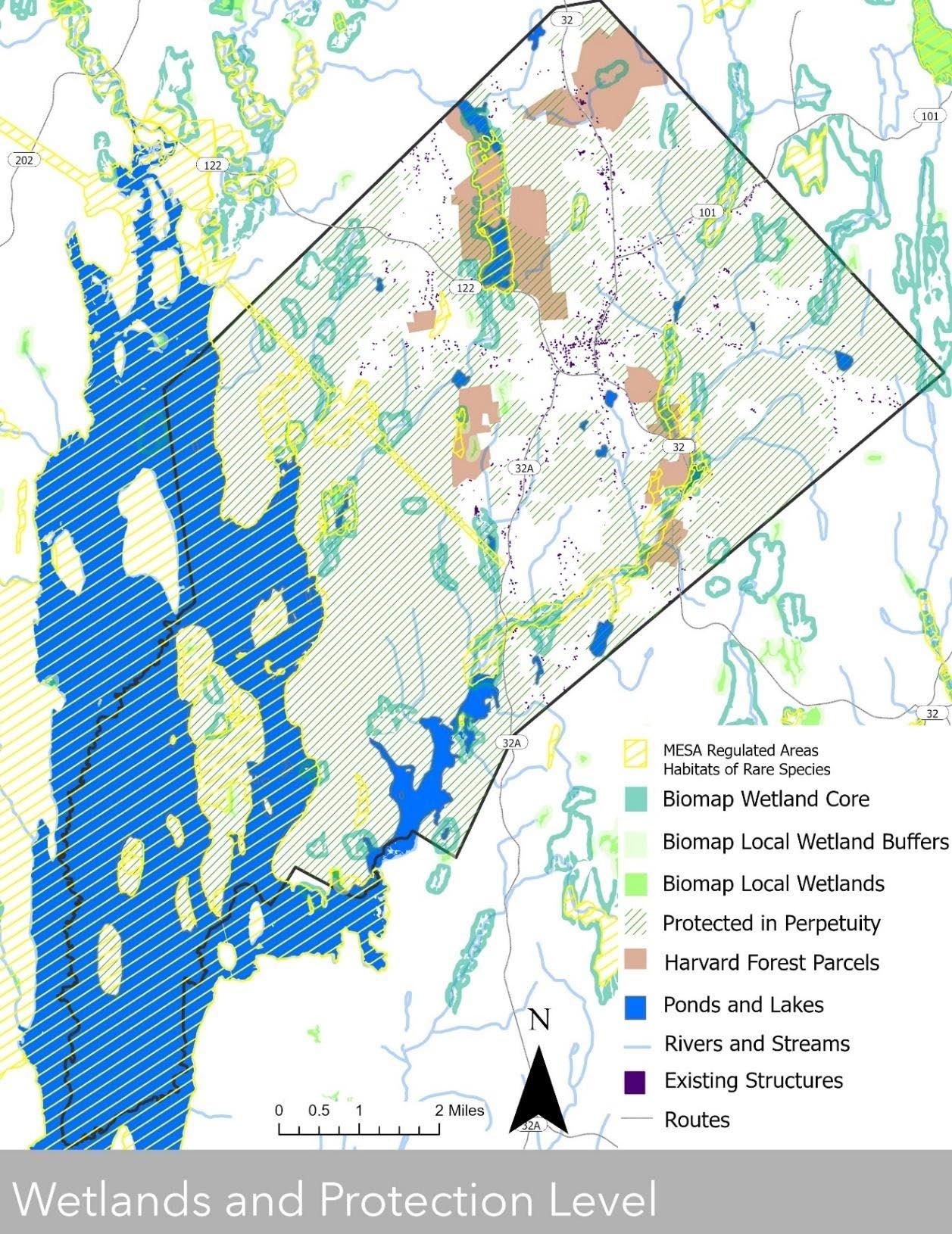
Many of Petersham’s wetlands are under permanent protection from development, while some areas have limited protection under the Massachusetts Endangered Species Act (MESA). Three of Petersham’s largest wetlands, while currently intact under the ownership and care of Harvard Forest, have varying levels of permanently protected area. Additionally, the landscapes surrounding many wetlands remain unprotected, leaving the future health of these wetlands at risk. Sources: MassGIS Data Layers: Protected and Recreational Open Space, Town Assessor’s data, Building Structures (2D), Hydrography 100k, BioMap, MASSDOT Roads, Quabbin Reservoir Bathymetry
Section 4
Petersham 2024 OSRP
pg. 59
Map 4-9: Vernal Pools and Protection Level Map
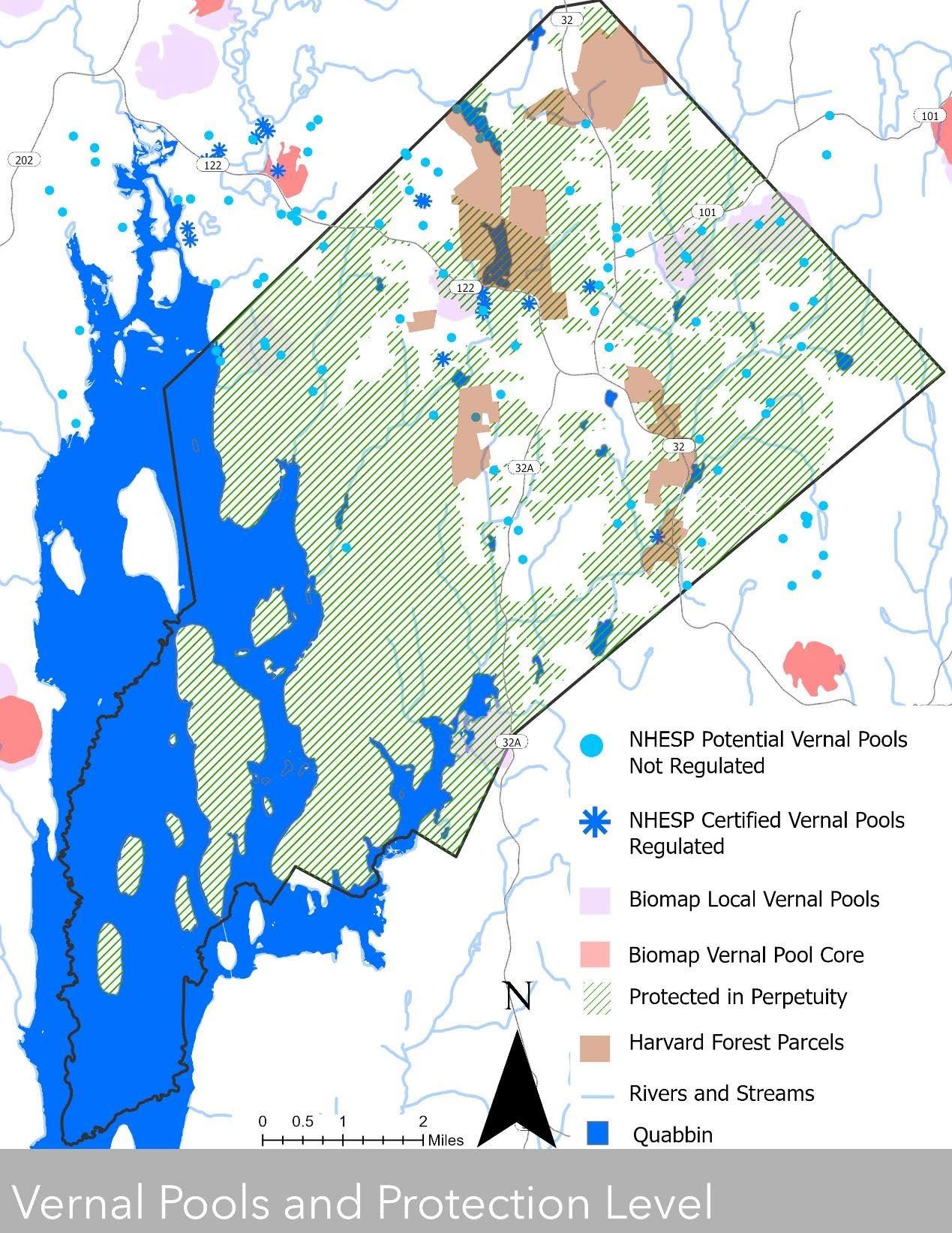
Development of areas designated as NHESP Certified vernal pools are regulated under the Wetlands Protection Act. Many of Petersham’s potential vernal pools mapped by the NHESP are not certified and not under permanent protection, so are potentially vulnerable to development and destructive forestry practices. There are no vernal pools of statewide importance (BioMap Vernal Pool Core) within Petersham, but five areas of local importance have been identified (BioMap Local Vernal Pools) These areas have clusters of pools that have intact upland habitat, which is critical to pool health, and are considered ecologically significant because of wildlife abundance or rare species presence, and all are at least partially protected in perpetuity. Sources: MassGIS Data Layers: Protected and Recreational Open Space, Town Assessor’s data, Hydrography 100k, BioMap, NHESP Priority Habitats of Rare Species, NHESP Estimated Habitats of Rare Wildlife, NHESP Certified Vernal Pools. NHESP Potential Vernal Pools, MASSDOT Roads, Quabbin Reservoir Bathymetry
Section 4 Petersham 2024 OSRP pg. 60
Section 4D Vegetation
Regional Ecosystem
A combination of soils, bedrock, and topographic characteristics put Petersham on the fuzzy boundary between two ecoregions: the Lower Worcester Plateau of the Southern New England Coastal Plains, and the Worcester Plateau of the Northeastern Highlands. The general vegetation types included in both ecoregions include transition hardwoods of maple-beech-birch, but the northern Worcester Plateau ecoregion includes northern hardwoods with pockets of spruce on the higher hilltops, while the southern Lower Worcester Plateau ecoregion features central hardwoods of oak-hickory, as well as elm-ash-red maple and white pine (Mass Audubon). However, the border between these two ecoregions is not discrete, but indicates that their natural communities gradually shift through the transition from one region to the next.
Petersham’s Forests
Research conducted in the forests of the area reveals that the vegetation today is quite different to what the colonists found when they began arriving in Petersham in the mid-1730s. The forests of the early 1700s were a two-tone quilt, with northern hardwoods on the cooler highlands and oakhickory on the warmer lowlands (Black and Brinser). Chestnut ran through both types of forest as did patches of white pine and areas of Eastern hemlock. Since that time, several changes have occurred. Most notably, about 80% of the Town’s forests were at one time cleared for farming. This not only changed the vegetation in the short term, but also resulted in changes to the soil composition, nutrient content, and seed bank such that the forests that eventually recolonized the landscape were often different from those that had existed previously.
Today, the forest canopy is more like one large piece of mottled cloth. Conifer patches of Eastern hemlock and white pine fade to areas of mixed hardwoods including maple, beech, and oak. Due to the disturbances of the 1938 hurricane, settler-colonial clearing of the landscape up through the early twentieth century, and the chestnut blight of the early twentieth century, many of the forests in Petersham are even aged and under a century old. The town’s western forests reflect the slightly warmer, lower elevation landscape of the Lower Worcester Plateau with pockets of oak-hickory central hardwoods, while its eastern half contains relatively fewer.
Rare forest communities mapped by the NHESP Natural Communities data include three Red Spruce swamps, a Sugar Maple-Oak-Hickory forest and Hickory-Hop Hornbeam woodland, an Oak-Hemlock-White Pine circumneutral (approximately neutral-pH) talus forest on ultramafic bedrock pocket, an Acidic Rock Outcrop community, and a large, relatively undisturbed OakHickory forest on Camel’s Hump Hill (see Map 4-10). These rare and endangered vegetative communities, as well as those that are unmapped, are important hotspots for biodiversity in town.
One of the many ecosystem benefits provided by Petersham’s forests is the health of the Quabbin Watershed. The vast tree cover holds soil and reduces water body eutrophication from nutrient and pollutant runoff. In fact, the DCR Division of Watershed Management states that its primary goal is to “promote healthy forest cover on the vast majority of the lands it owns and manages.” (DCR Division of Watershed Management).
Section 4 Petersham 2024 OSRP pg. 61
Petersham’s forests are also playing a big role in carbon sequestration. Data collected by the Department of Water Supply Protection indicate that the carbon dioxide storage in the DCR Quabbin watershed lands grew from an average of 85 tons per acre per year in 1970 to 153 tons per acre per year in 2010 (DCR Division of Watershed Management). Although these data are collected from the entire DCR watershed land and are not only representative of Petersham, it suggests that Petersham’s forests are part of a critical carbon sink resource.
Street Trees
The public shade trees on the common and in town cemeteries are especially prized by residents. When trees must be removed due to damage or decay, replacement trees are planted. Petersham’s roadsides are generally flanked by its vast forests, and the character of the town’s roads has become increasingly important to townspeople. Petersham’s Planning Board adopted the bylaw Rules and Regulations Governing Scenic Roads in 1977 to promote tree cover, safeguard the viewshed, and require replacement of stone walls along the roads for a number of roads in town.
The 2014 OSRP cites community interest in planting native shrub species, especially flowering shrubs, along roadsides to reduce roadside maintenance. Current roadside maintenance conducted by the Highway Department includes selective roadside mowing, and National Grid utility workers also cut back woody vegetation to maintain clear power lines.
Open Landscapes
Pockets of open, non-forested lands add critical habitat diversity in Petersham’s heavily forested landscape. Agricultural land is a major component of these open landscapes, and while it provides crops for humans, it also provides habitat for many species of conservation concern. Research at Harvard Forest’s Harvard Farm in Petersham is exploring the relationship between grazing intensity and biodiversity, and inventorying species on working landscapes, including bobolinks and woodcocks. This research can help Petersham to better understand how to encourage sustainable agricultural practices that bolster biodiversity across the community.
Another important open landscape is the utility right-of-way that runs from the northwest to the southeast. It is mapped by the NHESP as a Priority Habitat of rare and endangered species, and as such is regulated under MESA. It is unclear if encroaching woody vegetation on this landscape is chemically treated, but this may have a significant impact on the rare species depending on this landscape.
Rare Plant Species
Petersham contains fifteen rare plant species that are endangered, threatened, or of special concern according to the Natural Heritage and Endangered Species Program. Eleven of these have been observed in the last thirty years; and four have not been seen since the 1930’s. However, this list is likely an incomplete picture of the rare wildlife present within town, as rare and endangered species are in many cases difficult to find. Additionally, citizen science organizations have identified species such as the purple pitcher plant (Sarracenia purpurea), and toothed tick-trefoil (Desmodium cuspidatum).
It is well documented in ecological literature that vegetation and wildlife respond to bedrock pH and corresponding available nutrients (Searcy et al;) (Anderson & Ferree). In Massachusetts,
Section 4 Petersham 2024 OSRP pg. 62
most bedrocks are acidic, lower-nutrient types, with relatively few areas of calcareous, nutrientrich bedrock and surficial materials. Correspondingly, many of the rarer species in the state are those that are found in ecological communities that form on the rarer, calcareous bedrock. Petersham’s landscape is underlain with both acidic and calcareous bedrock, so this is likely one of the drivers of ecological diversity in the community. According to the NHESP Fact Sheets, eight of the fifteen rare plant species are dependent on nutrient-rich, calcareous or circumneutral environments that are typically driven by mafic bedrock types (see Table 4-4).
Species Spotlight: Sweet Coltsfoot
Sweet Coltsfoot (Petasites frigidus var. palmatus) has typically occurred in forested swamps and calcareous fens or seepages, often in the presence of red maple (Acer rubrum), white pine (Pinus strobus), yellow birch (Betula alleghaniensis) and balsam poplar (Populus balsamifera). This perennial wildflower rarely blooms in the state. According to its official NHESP Fact Sheet, Sweet Coltsfoot’s potential threats include “direct loss of adult plants during forestry activities and trail maintenance or development. Several invasive species, such as Coltsfoot, have colonized the remaining populations and may compete with it for space on forested hillsides. As a subarctic species at the southern extent of its range, P. frigidus may respond poorly to shifts in forest community structure caused by regional climate change” (Massachusetts Division of Fisheries and Wildlife Natural Heritage and Endangered Species Program, 2).
Section 4 Petersham 2024 OSRP pg. 63
Table 4-4: Rare and Endangered Plant Species with Abbreviated Habitat Description
Common Name Scientific Name
Sweet Coltsfoot Petasites frigidus var. palmatus
Adder's Tongue Fern Ophioglossum pusillum
Great Laurel Rhododendron maximum
Drooping Speargrass Poa saltuensis ssp. languida
Endangered 2023 calcareous
Threatened 2023 boggy meadows, acidic fens
Threatened 2022 acidic moist woods, swamps,
Endangered 2020 Calcareous
Purple Clematis Clematis occidentalis Special Concern 2020 calcareous
Climbing Fumitory Adlumia fungosa Special Concern 2019 calcareous
Appalachian Bristlefern Crepidomanes intricatum
Endangered 2018 circumneutral to high pH
Back's Sedge Carex backii Endangered 2016 dry, rocky, calcareous
Eastern Dwarf Mistletoe Arceuthobium pusillum Special Concern 2009 Peatlands
Tuckerman's Sedge Carex tuckermanii Endangered 2005 lowlands preferred
One-flowered Pyrola Moneses uniflora Special Concern 1995 woodland humus in cool, shady sites, open understory
Hairy Beardtongue Penstemon hirsutus
Endangered 1932 dry dolomitic limestone
Dwarf Rattlesnakeplantain Goodyera repens Endangered 1931 Unclear
Tiny Cow-lily Nuphar microphylla
Endangered 1931 shallow, still, or slow circumneutral waters
Long's Bittercress Cardamine longii Endangered 1923 tidal conditions
The largest group of rare and endangered plant species in Petersham depend on circumneutral conditions, which is likely driven by the presence of ultra-mafic and mafic bedrock. Two species depend on acidic bogs or peatland landscapes. Therefore, in terms of biodiversity conservation efforts, parcels on mafic bedrock types may be of greater value for the town because they are more likely to offer higher vegetative species richness than metamorphic or granitic bedrock types. Sources: Division of Fisheries and Wildlife Endangered Species Program Rare Species Viewer and Species Fact Sheets
Section 4 Petersham 2024 OSRP pg. 64
MESA Status Most recent observatio n NHESP profile habitat description
Section 4E Fisheries and Wildlife
Wildlife and Habitats
Although largely forested, Petersham contains a wide range of habitats including croplands, meadows, wetlands, vernal pools, rivers, and streams. In addition to the many private parcels protected in perpetuity by Petersham residents, DCR’s protection of the Quabbin watershed has contributed significantly to the quality of forests, wetlands, ponds, rivers, and streams within these large contiguous landscape blocks, which in turn secure homes for a range of wildlife. Common species seen throughout the town include beaver, black bear, wild turkey, moose, muskrat, mink, porcupine, bobcat, coyote, snowshoe hare, whippoorwill, musk turtles, red backed salamander, pumpkinseed fish, brook trout, tessellated darters, and freshwater pearl mussel among many others (iNaturalist). Not only does the protected land surrounding the Quabbin ensure contiguous habitat, but the reservoir itself is a large freshwater habitat that many other wildlife species depend on, including blue heron, green heron, North American river otter, yellow perch, and Eastern elliptio mussels.
Rare Wildlife Species
Petersham is home to 25 NHESP verified species that are endangered, threatened, or of special concern (see Table 4-5). Twenty-one of these have been observed in the last thirty years, but a handful have not been seen since the 1970s or 80s. However, this list is likely an incomplete picture of the rare wildlife present within town, as rare and endangered species are in many cases difficult to find. Citizen scientists on iNaturalist have identified additional rare and endangered species such as merlin falcon (Falco columbarius), golden-wing warbler (Vermivora chrysoptera), four-toed salamander (Hemidactylium scutatum), and spotted turtle (Clemmys guttata).
The largest group of MESA protected species in Petersham are those dependent on riparian habitats. The Quabbin Reservoir provides habitat for rare species that depend on large freshwater bodies, including populations of bald eagles and loons. The Swift River and the many clean brooks and streams through the town also likely provide important habitat for many of the riparian species documented (see Map 4-11).
Wetland Habitat
Although only 4% of Petersham is wetland land cover, the second largest habitat-dependent group of documented NHESP wildlife species of concern are wetland dependent species, and eight of those are specifically dependent on acidic bogs or peatlands. The Massachusetts Wetland Protection Act, enforced by the Petersham Conservation Commission, offers protection for wetlands themselves, but the uplands that drain into wetlands are not protected under this legislation. To protect the health of Petersham’s wetlands, their connected uplands must be protected (see Map 4-8).
Section 4 Petersham 2024 OSRP pg. 65
Vernal Pool Habitat
Vernal pools, also known as ephemeral pools, are the breeding grounds for many amphibians because they dry out after spring rains and do not support predatory fish species that would otherwise eat amphibian eggs. Interestingly, many vernal-pool-dependent species are pool specific, meaning that they will only return to the pool in which they were born. Without Petersham’s vernal pools, populations of species like the spotted salamanders, wood frogs, and the spatterdock darner dragonfly (three species spotted in Petersham by citizen scientists on iNaturalist) would dwindle.
Vernal pools are not protected from development under MESA unless certified by the NHESP program (see Map 4-9). Petersham currently has nine NHESP certified vernal pools and fiftynine potential vernal pools. In addition, the state has identified five BioMap vernal pool core habitat areas areas with clusters of pools that have intact upland habitat, which is critical to pool health, and are considered ecologically significant because of wildlife abundance or rare species presence. However, only two of Petersham’s thirteen pools located within the vernal pool core areas are certified, so these pools may be considered priority for certification. To protect these sensitive habitat areas, it is critical that they are NHESP certified so that recreation activities and development projects are regulated by MESA and the local Conservation Commission.
Early Successional Habitats
Some of the wildlife species listed depend on a diversity of habitat types to meet their reproductive, forage, and housing needs. Like much of New England, Petersham’s natural land cover is primarily forested (see Map 3-2) and excepting the utility strip in the western half of town and the agricultural fields, offers minimal habitat for open-landscape-dependent species. Many of the state’s listed rare and endangered species are those that depend on these early successional habitats. If Petersham wants to maintain or improve their populations of wildlife that require these habitats, the town will need to prioritize their protection and management.
Species Spotlight: Eastern Whippoorwill
The Eastern whippoorwill is an insectivorous, nocturnal, ground nesting bird. Their camouflage hides them well against the forest floor, and so they are rarely seen, but their call can be heard most easily on moonlit summer nights. Their habitat needs are not fully understood by the scientific community, but open woodlands are considered important for nesting while nearby meadows and shrublands may be used for forage. Little is known about their breeding habits, and even less about their migration patterns. Most known habitat sites support a single breeding pair, with less than twenty sites supporting multiple pairs. State conservation recommendations include protecting existing habitat and reintroducing a locally tailored disturbance regime to the landscape, such as prescribed fire.
Section 4 Petersham 2024 OSRP pg. 66
Table 4-5: Rare and Endangered Wildlife Species with abbreviated habitat description
Common Name Scientific Name
Eastern Whippoorwill
Antrostomus vociferus
Pink Sallow Moth Psectraglaea carnosa
Wood Turtle Glyptemys insculpta
Bald Eagle Haliaeetus leucocephalus
Orange Sallow Moth Pyrrhia aurantiago
Pitcher Plant Borer Papaipema appassionata
Eastern Hognosed Snake Heterodon platirhinos
Ebony Boghaunter Williamsonia fletcheri
Most recent observat ion NHESP profile habitat description
Bird Special Concern 2021 diversity: open habitat and dry, open woodlands
Butterfly/ Moth Special Concern 2020 Acidic-loving vegetation
Reptile Special Concern 2020 riparian areas with sandy banks
Bird Threatened 2020 forest shoreline habitat
Butterfly/ Moth Special Concern 2019 open woodlands and open habitats
Butterfly/ Moth Threatened 2019 acidic sphagnum bogs
Reptile Special Concern 2019 many types of habitat
Dragonfly/D amselfly Endangered 2019 sphagnum bogs
Common Loon Gavia immer Bird Special Concern 2018 highly water dependent
Ski-tipped Emerald Somatochlora elongata
Spine-crowned Clubtail Hylogomphus abbreviatus
Creeper Strophitus undulatus
Twelve-spotted Tiger Beetle Cicindela duodecimguttata
Bog Elfin Callophrys lanoraieensis
Eastern Box Turtle Terrapene carolina
Harpoon Clubtail Phanogomphus descriptus
Slender Clearwing Sphinx Hemaris gracilis
Blue-spotted Salamander Ambystoma laterale
Forcipate Emerald Somatochlora forcipata
Incurvate Emerald Somatochlora incurvata
Dragonfly/D amselfly Special Concern 2016 streams
Dragonfly/D amselfly Special Concern 2016 large streams and rivers
Mussel Special Concern 2009 small to large rivers, low to moderate water velocities
Beetle Special Concern 2009 open areas with silty or sandy soil
Butterfly/M oth Threatened 2009 black spruce swamps/peatlands
Reptile Special Concern 2004 many types of habitats
Dragonfly/D amselfly Endangered 2001 clear, cold streams with intermittent sections of rocks and rapids
Butterfly/ Moth Special Concern 2001 pitch pine-scrub oak barrens, rocky ridges, acidic bogs and swamps
Amphibian Special Concern 1999 lowlands, depressions, vernal pools
Dragonfly/D amselfly Endangered 1998 bogs and pools in small, forested streams
Dragonfly/D amselfly Endangered 1998 sphagnum bogs
Section 4 Petersham 2024 OSRP pg. 67
Taxonomic Group MESA Status
American Bittern Botaurus lentiginosus
Bridle Shiner Notropis bifrenatus
Intricate Fairy
Shrimp Eubranchipus intricatus
Grasshopper
Sparrow Ammodramus savannarum
Sedge Wren Cistothorus platensis
Bird Endangered 1997 freshwater marshes, fens, bogs dominated by emergent vegetation
Fish Special Concern 1990 clear water in slack riparian areas, lakes, ponds
Crustacean Special Concern 1985 vernal pools
Bird Threatened 1972 patchy grassland habitat, bare ground
Bird Endangered 1971 wet meadows, marshes
Nineteen of Petersham’s twenty-five NHESP rare and endangered species depend on water-rich habitats, implying that the quality of Petersham’s watershed is critical to its biodiversity. Additionally, although wetlands only comprise 4% of the total land cover, nine of the twenty-five species depend on wetland habitat for survival. Protection of the few wetlands within town will go a long way to protect species richness.
Data Sources: Division of Fisheries and Wildlife Endangered Species Program: Rare Species Viewer and Species Fact Sheets
Wildlife Corridors and Habitat Connectivity
Petersham’s large blocks of minimally developed areas provide excellent connected habitat, particularly to the west approaching the Quabbin. Roads are known to be a major restrictor of wildlife movement (Shepard et al.). Currently, Petersham’s subdivision bylaws (Zoning Bylaws Section 19) restrict the construction of new roads and subdivisions, and the minimal number of roads in town relative to other municipalities likely protects habitat contiguity
Where major roads and development do occur in Petersham, the BioMap Core and Critical Natural Landscape regions split and shrink. This is most apparent in the town center and northwards along Route 32, which are the major fragmenting areas in town that bisect otherwise relatively contiguous habitat. Development outside of these areas could significantly impact the health and quality of ecological systems in town (see Map 4-12).
Section 4 Petersham 2024 OSRP pg. 68
Map 4-10 Protected and Unprotected BioMap Elements
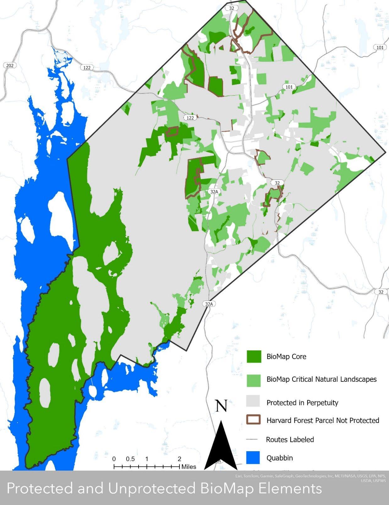
Even though Petersham has put over 70% of its land into protection in perpetuity, critical habitat areas remain unprotected. BioMap areas are not regulated. BioMap core areas are considered critical to the long-term persistence of Species of Special Concern, exemplary natural communities, and intact ecosystems. Critical Natural Landscape areas are those that are able to support a diversity of species, habitats, ecological processes and disturbance regimes. Both are critical to Petersham’s ecological health and long-term resilience. Sources: MassGIS Data Layers: Protected and Recreational Open Space, Town Assessor’s Data, BioMap, MASSDOT Roads, Quabbin Reservoir Bathymetry
Section 4
Petersham 2024 OSRP
pg. 69
Map 4-11: NHESP Estimated and Priority Habitats
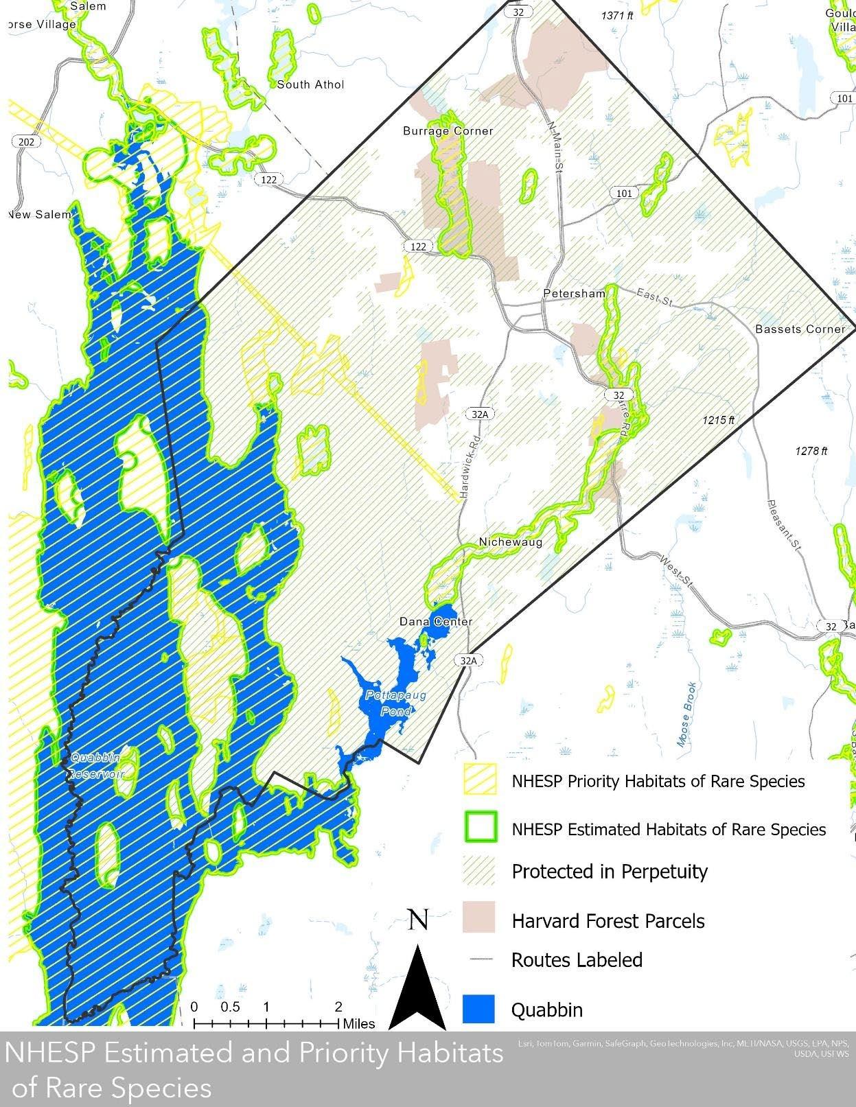
Both NHESP Priority and estimated habitat areas are regulated by the state. NHESP Priority Habitats are areas known to support state listed rare plant and animal species and they are protected from habitat alteration under MESA. Estimated Habitat areas are a subset of Priority habitats that specify areas of state-listed rare wetlands wildlife, but do not protect plants. Many of these areas critical for the health of rare wildlife are only partially protected. Also, although areas on Harvard Forest parcels are currently well stewarded and protected by the institution, they are not protected in perpetuity Sources: Mass GIS Data Layers: Protected and Recreational Open Space, Town Assessor’s data NHESP Estimated Habitats, NHESP Priority Habitats, BioMap, MASSDOT Roads, Quabbin Reservoir Bathymetry.
Section 4 Petersham 2024 OSRP pg. 70
Connectivity
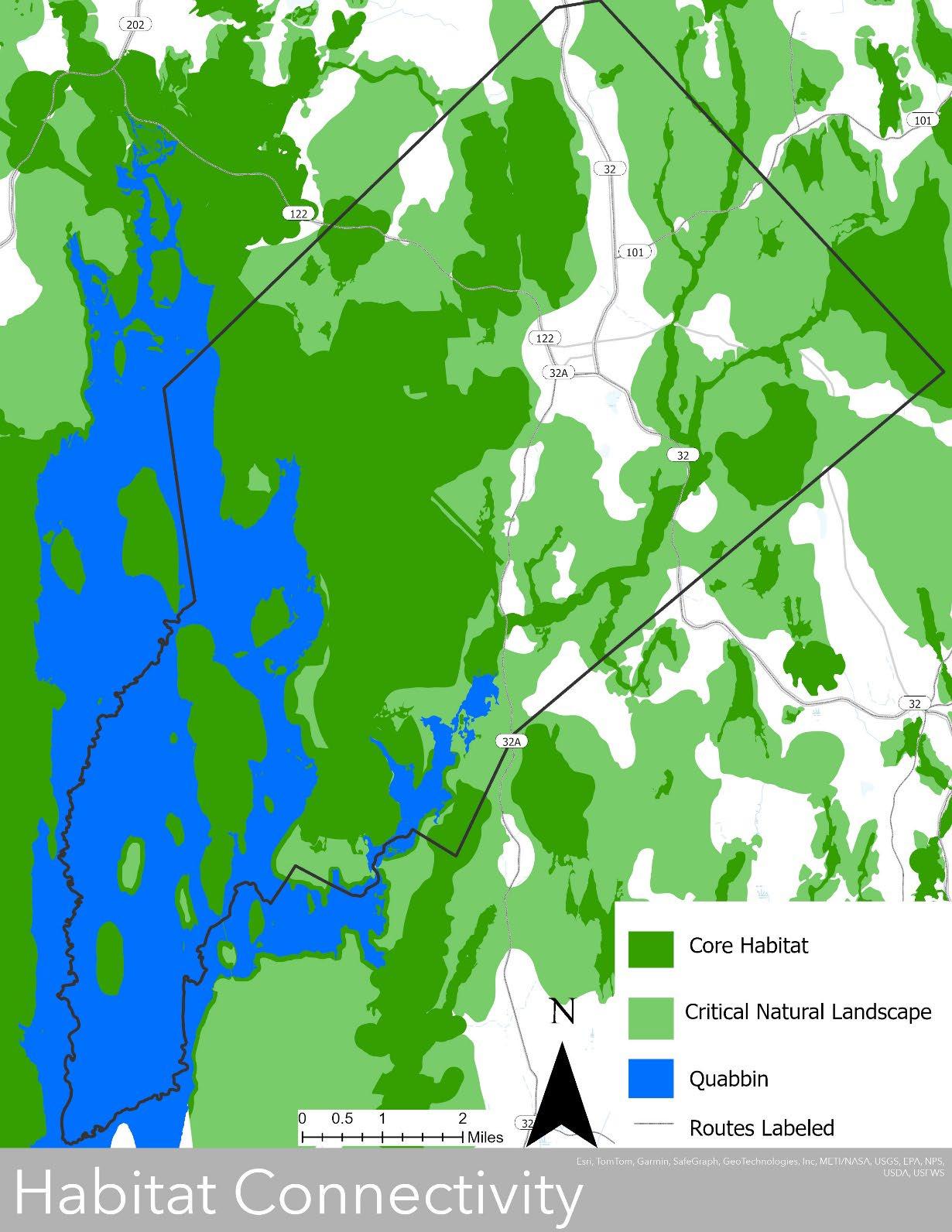
Petersham’s large blocks of minimally developed areas provide excellent connected habitat, particularly to the west approaching the Quabbin. The town center and Route 32 are the major fragmentation areas in town that bisect otherwise relatively contiguous habitat. Development outside of these areas could significantly impact the health and quality of ecological systems in town. Sources: Mass GIS Data Layers: MASSDOT Roads, NHESP Core Habitat, NHESP Critical Natural Landscape, Quabbin Reservoir Bathymetry.
Section 4
Petersham 2024 OSRP
pg. 71
Map 4-12: Habitat
Section 4F Scenic Resources and Unique Environments
Landscapes
Scenic resources and unique environments are landscape features that help define a community’s character and visual appearance. Petersham has numerous such landscape features. Most people observe Petersham’s scenic beauty as they drive, bike or walk along the Town’s roads or use the many trails, virtually all of which (except for the state highways) have been designated as Scenic Roads under the Town’s scenic roads provision (see Map 4-4).
Open fields and farmland are among the most beautiful landscape features in Petersham. These areas offer a window into Petersham’s agricultural past, and in many cases also provide sweeping vistas of the surrounding hills. The most extensive open fields are along East Street and especially on Maple Lane. Other notable open lands are located on North Main Street, off Nichewaug Road, and at the North Common Meadow in the town center. Open landscapes are increasingly rare in Petersham and are continually at risk of growing up to become forests if they are not mowed or grazed. Once these landscapes revert to forest, it is rarely economically feasible to return them to farmland again. The Conservation Commission has been very supportive of pasture reclamation.
Petersham has a wide variety of beautiful, wooded landscapes laced with brooks and streams. The Swift River Reservation and the area around Connor Pond are among the most gorgeous of these. Petersham’s landscape is fairly hilly and offers several beautiful hilltop vantages. For example, panoramic views of the Quabbin Reservoir can be enjoyed from the top of Soapstone Hill in the Federated Women’s Club State Forest, while a 360-degree view of Petersham and the surrounding towns is available from the fire tower on Prospect Hill, which is on Harvard Forest land (the tower itself is just over the border in Phillipston).
Cultural, Archaeological, and Historic Areas
The Petersham Historic District, which is listed on the National Register of Historic Places, extends along from the northern end of North Street and along Route 32 to Barre Road (Route 122) in the south, and along the full length and both sides of the Common. The district includes 32 homes and fourteen properties, many of which date from the early nineteenth-century. The district was designated as a Local Historic District in 1966 one of the first historic districts in Massachusetts. In 1982, it was expanded and listed on the National Register.
The 2014 OSRP cited A Guide to Petersham’s Historic District and Historic District Fact Sheets made by Petersham’s Historic District Commission and Historic Commission for the following:
Notable buildings within the Petersham Historic District include the Country Store, Petersham Memorial Library, Sims Property, Brooks Law Office, Winterwood at Petersham, and the Petersham Craft Center. Buildings within the district date from 1735 to 1899 and include a variety of architectural styles such as Greek Revival, Colonial, Georgian, Federal, and Victorian. In addition to the historic buildings, key properties in the district include the town common, North Cemetery, and North Common Meadow.
Section 4 Petersham 2024 OSRP pg. 72
Four buildings in Petersham are listed individually on the National Register of Historic Places: Gay Farm on Gay Drive off of Nichewaug Road; the Holland Towne House on Ward Hill Road off of Route 32; the Petersham Craft Center at 8 North Main Street; and the Prescott Town House on Route 32. The Town’s landscape, of course, is one of its most important historic resources. Stone walls, cellar holes, and other remnants of early farmstead life may be found throughout the Town, although some of these artifacts have been obscured and blended into the natural landscape with the passage of time. The Town also has eleven cemeteries, eight of which are historic cemeteries no longer in use.
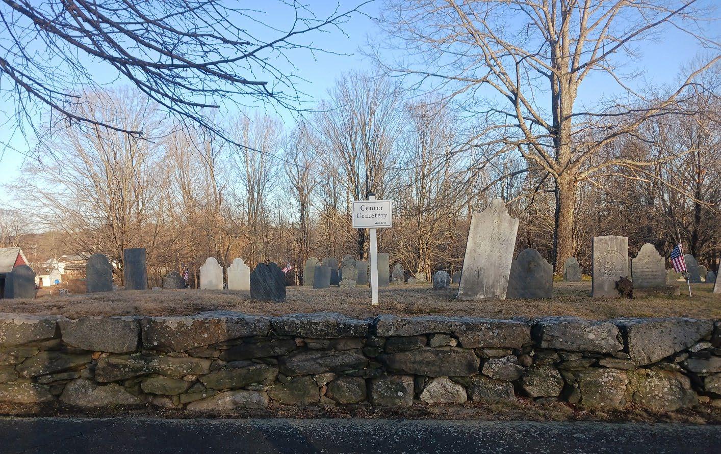
Cultural and recreational facilities in Petersham are many and varied, including the Petersham Art Center, the Historical Society with its museum, the Memorial Library, Petersham Country Club, Curling Club, the Fisher Museum at Harvard Forest, summer band concerts staged at the renovated bandstand, impressive Memorial Day ceremonies, numerous hiking and skiing trails, the Petersham Gun Club, Elizabeth Carpenter Concerts, and the antique show and other events sponsored by the American Legion, Grange, Lions Club and the Town’s three churches.
Section 4 Petersham 2024 OSRP pg. 73
Center Cemetery, Petersham Massachusetts
Special Places in Petersham
compiled January 2004 by Conservation Commission, Historical Society, and town residents
1 scenic / Tumbledown Hill - Brooks Woodland Preserve Parcel No. 288
2 aquatic / Cardinal Brook at old mill wall Parcel No. 440
3 aquatic East Branch Swift River system
4 natural / Drumlin - North of East Street just east of Quaker Drive Parcel No. 407
5 aquatic / Sputtermill Brook East of Monson Turnpike
6 open space / Orchard and corn field on Quaker Drive Parcel No. 293
7 aquatic / Beaver pond on East Branch Fever Brook "Phillips Swamp" Parcel No. 658 & 660
8 scenic / View from top of hay field at north end of Harty Drive Parcel No. 432
9 open space / Open field south of East Street opposite Maple Lane Parcel No. 353 & 355
10 natural / Strawberry Rock (glacial erratic) Parcel No. 695?
11 aquatic / Carter Pond Parcel No. 199
12 aquatic / Moccasin Brook River system
13 open space / North Common Meadow Parcel No. 377
14 aquatic /Connor's Pond Parcel No. 299
15 scenic / Sherman Hill Parcel No. 320
16 aquatic / Brown's Pond and Mill site Parcel No. 363 & 364
17 historic / Nichewaug Open Space Site (Hotel structures demolished 2022)
18 open space / Open fields along North Main Street
19 scenic / Soapstone Hill Quabbin Reservation
20 aquatic / Davenport Pond Parcel No. 504
21 historic / The Common Parcel No. 001 & 050
22 aquatic / Popple Camp Brook and headwaters Northeast portion
23 historic / Poor Farm Road (foot path) east of North Main Street
24 scenic / Glen Valley Road, Nichewaug
25 scenic / Quaker Drive - East Street to Barre Road
26 scenic / Maple Lane north of East Street
27 scenic / Oliver Street South part First Flat Iron
28 natural / Trail east of Bald Hill Parcel No. 674 & 676
29 historic / School District No. 1 - Central Parcel No. 026
30 historic / School District No. 2 - North or Bell (site) Parcel No. 543
31* historic / School District No. 3 - Second North (site) Parcel No. 487 & 519
32 historic / School District No. 4 - First East or Ledgeville Parcel No. 405
33 historic / School District No. 5 - Second East Parcel No. 417
34 historic / School District No. 6 - First South (site) Parcel No. 149
35 historic / School District No. 7 - Second South or Factory Village (site) Parcel No. 176
36 historic / School District No. 8 - Second West (site) Parcel No. 630
37 historic / School District No. 9 - First West (site) Parcel No. 667
38 historic / School District No. 10 - Northwest (site) Parcel No. 607
39 historic / School District No. 11 - Northeast or Popple Camp (site) Parcel No. 458.2
40 historic / School District No. 12 - Southeast (site) Parcel No. 306
41 historic / School District No. 13 - Southwest (site) Parcel No. 713
42 historic / Old Petersham Center School or Petersham High School Parcel No. 098
43 historic / East Street Cemetery Parcel No. 370
44 historic / The Indian Cemetery Parcel No. 425
Section 4 Petersham 2024 OSRP pg. 74
45 historic / West Road Cemetery Parcel No. 698
46 historic / Center or Village Cemetery Parcel No. 024
47 historic / North or Mann Cemetery Parcel No. 483
48 historic / Ledgeville, Second East, or Gates Cemetery Parcel No. 357
49 historic / Coolidge/Goddard or Hardwick Road Cemetery Parcel No. 137
50 historic / Nichewaug or Second South Cemetery Parcel No. 171
51 historic / Flat Rock Road or Northwest Cemetery Parcel No. 600
52 historic / Poor Farm Burial Plot Parcel No. 471
53 historic / Howe Family Plot (private) - Maple Lane Parcel No. 440
54 historic / Lincoln Cemetery (site) - south of Meadow Water Parcel No. 684
55 historic / "Indian Caves" - Glasheen Road Parcel No. 410
56 historic / Stone Water Trough - Old New Salem Road Parcel No. 568
57 historic / Stone Water Trough - east end Ward Hill Road East end Ward Hill Rd.
58 historic / Babbitt house (James Baird) - Gay Drive Parcel No. 150.1
59 historic / Negus celler hole Parcel No. 148
60 natural / Boiling spring - Lewis and Corinne Babbitt Wildlife Sanctuary Parcel No. 150
61 natural /Quabbin Reservation
62 natural / Kettle holes west of gate 41, Quabbin Reservation
63 aquatic / "Cinderella Steps" - Roaring Brook - north of East Street Parcel No. 384
64 scenic / View of Mt. Monadnock from north end of Maple Lane Parcel No. 440
65 scenic / Slab City Parcel No. 239
66 historic / Mill site on Swift River downstream from the Carruth Road Parcel No. 219
67 historic / Mill site on East Branch Fever Brook south of Route 122 Parcel No. 684
68 historic / Mill site on East Branch Fever Brook east of Camel's Hump Road Parcel No. 699
69 historic / Mill site on East Branch Fever Brook - Doubleday Village, Quabbin Reservation
70 historic / Steam Powered mill site on northwest side of Meadow Water Parcel No. 572
71 historic / Parlin's Mill site on Swift River - Factory Village - Nichewaug Parcel No. 178
72 natural / Harvard Pond/Tom Swamp Tract Parcel No. 583
73 natural / Black Rock Parcel No. 282
74 natural / Choat Ledges - Nichewaug Tract - Swift River Reservation Parcel No. 232
75 natural / Rocky hillside on Woodward Road Parcel No. 192.2 & 192.3
76 natural / East side Camel's Hump Hill Parcel No. 700
77 historic / "Petrified Man" Tomb - Carter Pond Road Parcel No. 194
78 historic / Lion's Den Parcel No. 181
79 historic / Woodward Cemetery (site) - Dana Road (Gt. 40) Parcel No. 726
80 historic / Peter Gore's Spring - Popple Camp Road Parcel No. 451
* 2 locations School District No. 3 - Second North (site)
Section 4 Petersham 2024 OSRP pg. 75
Section 4G Environmental Challenges
Because Petersham is not heavily developed and does not have a history of major industry, it is fortunate to have escaped many of the environmental problems that plague other New England communities. Nevertheless, there have been a couple of environmental problems worth noting.
The first problem pertains to the treatment and disposal of wastewater in the town center, where the low permeability of soils (see Map 4-1, Table 4-1) has led to problems associated with malfunctioning on-site wastewater systems. Septic problems have been addressed through individual system upgrades and installation of a special septic system at the Country Store.
A more general potential concern in Petersham as in every community is nonpoint-source pollution (NSP). This issue is of special importance within the Quabbin watershed, where waterborne pollutants may enter the water supply. NSP refers to pollution generated by modern human activities in the landscape, rather than pollution emanating from a specific outfall pipe. Common sources of NSP include road salt, septic systems, runoff from paved surfaces, animal wastes such as dogs along trails, residential lawn chemical and fertilizer use, and the runoff produced from agricultural fertilizer, pesticide, herbicide, and livestock waste.
Most roads in Petersham are paved, and in town center and along Routes 122, 32, and 32A there is a stormwater system of just over one hundred catch basins and drop inlets. Storm drains are possible vectors of concentrated NSPs in the form of de-icing agents and other road surface contaminants from automobiles.
The Town’s Highway Department yard is located adjacent to wetlands; however, the sand that is mixed with salt is kept in a covered shed. It is unclear if the adjacent wetlands are consistently monitored for salinity or other pollutants.
The NSP impact of new development is greatly influenced by the style and layout of the development. For example, providing narrower roadways, managing stormwater with vegetated swales and filters, and retaining native vegetation rather than replacing it with large lawns are all ways to reduce the NSP impact of new development. However, the Town does not currently have any development bylaws or private homeowner outreach around best management practices to address NSP impacts in town.
There are no known hazardous waste sites in Petersham. According to the 2014 OSRP, the former landfill was closed and monitored for a few years. Toxic materials were not found, and the site has become the Town Transfer Station.
Petersham has not historically had erosion or flooding issues as the soils are not susceptible to erosion, and most structures are built on upland areas not prone to flooding (see Map 4-7). However, according to the Conservation Commission, sedimentation accumulation along roadsides and along stream and river channels is becoming more of a problem as debris flow increases with climate-change-induced increases in precipitation and storm severity Maintaining forest and other vegetative covers along roadsides and encouraging best management practices for agriculture, forestry, and development sectors could potentially reduce sedimentation accumulation issues.
Petersham is a rural community with few roads, large areas of connected forest, much of which is protected in perpetuity from development. Harvard Forest’s world class forest management
Section 4 Petersham 2024 OSRP pg. 76
and ecological research in town gives Petersham a unique resource for ecological knowledge within town and contributes to the community’s strong sense of pride in habitat stewardship. However, suburban sprawl along roads is a present threat to the contiguity of and access to open space in town. According to the Petersham Building Inspector’s Annual Reports there were 17 new building permits in fiscal year 2022, which is a marked increase over the prior years. There is a distinct possibility that there will be more desire for housing development in town. Continued development along main roads could further fragment wildlife habitat, suburbanize the rural character of the town, and decrease access to nature-based recreational pursuits (for a full discussion of these issues see Sections 3-D3, 4B, and 4E, and Maps 3-8, 3-9, 4-4, and 4-12).
Local forests are also a valuable source of cordwood and sawtimber, and forestry remains important to the rural identity of the town. However, forestry issues such as cutting too close to wetlands and wetland buffers, and the negative effects of compaction induced by logging operations with heavy equipment on saturated soils are concerns. Due to the sensitivity of the Quabbin Reservoir Watershed, the DCR Service Foresters have worked with the town and private landholders to manage these issues, as well as the Petersham Conservation Commission (SWAP). The Conservation Commission is currently working on a local wetlands bylaw that could address forestry operations adjacent to wetlands, but there are currently no actions being taken to address soil compaction in town.
Invasive species are an issue that community members have voiced concern about. Invasive insect species present in the town that are of concern include the hemlock woolly adelgid (HWA), Asian long horned beetle, emerald ash borer, and spongy moth. As in many communities in New England, the emerald ash borer has significantly reduced ash tree population in town, and the HWA is continuing to devastate the hemlocks with little chance of recovery. The full impacts of the loss of these two trees on the forest ecology are unclear, but studies on the loss of hemlock, a key species throughout New England, are showing impacts on hydrology, nutrient cycling, and litter decomposition rates (Kim et al.) (Orwig et al.). Currently there are no treatments viable at the forest scale to address HWA or emerald ash borer.
Vegetative species present in Petersham that are listed by the state as invasive include garlic mustard, Japanese knotweed, multiflora rose, Japanese barberry, burning bush, and bittersweet, among others. The Conservation Commission has studied and the issue of the spread of Japanese knotweed in the town and conducted an informational meeting to inform residents of their findings. The Commission reported that Japanese knotweed is growing in three out of four town highway sites for holding gravel, sand, and organic debris, and are a likely a vector for spreading the species throughout town when these resources are used to repair both paved and unpaved roads. Additionally, annual flail mowing of Japanese knotweed as a roadside management technique is likely distributing live plant segments and rhizomes. Distribution of viable plant segments and rhizomes is likely occurring through disturbance along roadsides and development sites in town. The Commission identified as many as 31 roads and dumps where Japanese knotweed was growing and identified an additional 12 roads to be checked for the weed. Knotweed management strategies encouraged by the Conservation Commission included the cessation of flail mowing, disturbance of existing stands, and use of contaminated fill, as well as reducing existing stands by repeated cutting and solarization of cut vegetation and professional remediation of knotweed in contaminated fill and dump sites. The suggestion was also made to construct a hoop house on South Street for community solarizing of knotweed cuttings.
Section 4 Petersham 2024 OSRP pg. 77
These strategies would not only go a long way to remediate the spread of knotweed throughout town but could also potentially be used to address the many other invasive species present. While it is likely unfeasible to completely eradicate these species, addressing their main vectors of distribution and generating a strategic, long term maintenance plan for concerned residents to rally around is critical to addressing the issue and maintaining Petersham’s biodiversity.
Section
Petersham 2024 OSRP pg. 78
4
Petersham community members test out the viability of biochar as a component of a multi-pronged Japanese knotweed control strategy.
Section 5
Inventory of Lands of Conservation and Recreation Interest
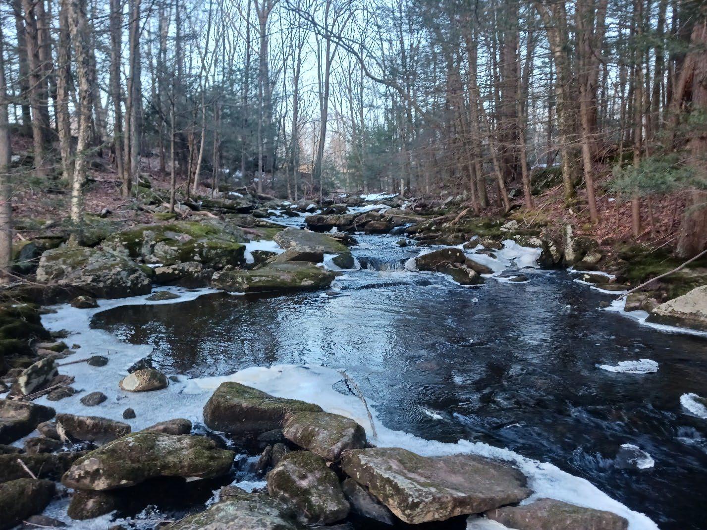
5 Petersham 2024 OSRP pg. 79
Section
Moccasin Brook, Petersham, Massachusetts
What is open space? According to the Commonwealth of Massachusetts, open space is land that is permanently protected from development through deed restriction or conservation easement, or land that is not permanently protected but is used for farming, forestry, or recreation. Open space also refers to land that is not permanently protected or used for farming, forestry, or recreation, but is nonetheless still important for conservation or recreation.
By this definition, Petersham is largely open space; there are 26,504 acres of open space, which is 76% of the town’s total 34,688 land acres excluding the Quabbin Reservoir. 24,757 acres are protected in perpetuity, which is 71% of the town’s total acreage. Chapter 61 lands cover 6,573 acres, increasing total percentage of land in Petersham that is protected open space, either temporarily or permanently, to 90%.
Type of Parcel
Open Space (includes undeveloped parcels –both protected and unprotected. Unprotected parcels include Harvard Forest and Petersham Gun Club)
of Land in Petersham
A large swath of open space next to the Quabbin Reservoir is owned by the Massachusetts Department of Conservation and Recreation for Water Supply Protection. There are also privately and municipally owned open space parcels in town, as well as open space land owned by land trusts, the State Division of Parks and Recreation, and the Department of Fish and Game.
The large amount of conservation land in Petersham protects the Quabbin Reservoir Watershed. Within the forested buffer adjacent to the Quabbin Reservoir rare plant and wildlife species thrive, and the intact forest contributes to one of the largest areas of contiguous forest in New England. Petersham is also home to wetlands and vernal pools, but the sheer amount of forestland is the town’s greatest ecological asset. Petersham’s conserved lands play a vital role in ecosystem function across the state and the region; unfragmented forests allow for large wildlife corridors and provide critical habitat. Petersham residents value this conservation function of their town, as well as the outdoor recreation opportunities, rural character, and scenic views that their open space lands provide
Section 5.1: Open Space Inventory
Petersham's open space areas have been identified using data gathered from MassGIS, the Petersham Assessor’s Office, and other sources. These areas are categorized based on ownership and the degree of protection they receive, as outlined in Tables 5-1, 5-2, and 5-3. For instance, properties owned by the Department of Conservation and Recreation or subject to conservation restrictions face legal limitations preventing their development. Conversely, lands owned by the Town of Petersham, not explicitly designated for conservation, may be developed by the Town itself or sold to other parties for potential development. The subsequent narrative offers insights into some of the town’s prominent public and private open space lands; language in the parcel descriptions is largely drawn from the 2014 Petersham OSRP.
Section 5 Petersham 2024 OSRP pg. 80
Percentage
76% Protected in Perpetuity 71% Chapter 61 + Protected in Perpetuity 90%
Map 5-1: Open Space by Owner
The large DCR-owned Water Supply Protection conservation area (turquoise) adjacent to the Quabbin Reservoir forms the basis of the forested landscape that Petersham is known for and that is integral to its rural character and outdoor recreation opportunities. Private conservation lands, such as those owned by Harvard Forest, add to the benefit of the DCR land by keeping parts of those forests intact in the center and northwestern parts of town. In the southeast, conservation lands owned by land trusts form a cluster of wildlife preserves and sanctuaries, increasing intact plant and wildlife habitat that contributes to the environmental health of the region and the state. Sources: MassGIS Data: Protected and Recreational OpenSpace, MassGIS Census Towns, MassDEP Hydrography (1:25,000)
Section 5 Petersham 2024 OSRP pg. 81
A. Private and Nonprofit Parcels
Petersham stands out due to the significant number of nonprofit organizations that either own land or actively engage in land conservation efforts within the town. These organizations include The Trustees of Reservations, Massachusetts Audubon Society, Harvard Forest, the East Quabbin Land Trust, and the Mount Grace Land Conservation Trust. Their involvement in Petersham generally stems from their recognition of the town's open spaces as crucial for advancing their respective missions. These missions may involve safeguarding wildlife populations, preserving and connecting habitats and agricultural lands, or protecting the most remarkable landscapes in Massachusetts. The descriptions below delve into the major private open space holdings in Petersham. The 2014 OSRP separated public lands (5.1B) from private and nonprofit (5.1A); the same format is replicated here.
a. Brooks Woodland Preserve: protected in perpetuity, public access, owned by The Trustees of Reservations, contains 558 acres of undisturbed forest, including red oaks, hemlocks, and white pine, which are being restored to the state they were in before colonial settlement, to the extent that that is possible. Hiking and cross-country skiing are allowed on the trails, and some fields that were once farmland have been maintained as fields within the forest. Swift River, Moccasin Brook, and Roaring Brook run through the property and beavers actively dam these streams, creating ponds throughout the preserve.
b. North Common Meadow: protected in perpetuity, limited public access, owned by The Trustees of Reservations, contains 25 acres located adjacent to the Brooks Woodland Preserve and across North Main Street from the town common. The meadow was once pastureland and, later, part of a golf course for the Nichewaug Inn. The lower meadow has a small pond covered in lilies and is full of wildflowers in the spring, while the upper meadow produces hay that is cut by a local farmer. Visitors standing next to the Petersham Historical Society building on North Main Street get a magnificent view of Mount Wachusett to the east.
c. Swift River Reservation: protected in perpetuity, limited public access, owned by The Trustees of Reservations, contains 439 acres, and includes three tracts (the Nichewaug, Davis, and Slab City tracts), which are linked together by the East Branch of the Swift River. In the late 18th century, much of the Reservation was cleared for small-scale agriculture, subsistence livestock grazing, and firewood collection. These activities, combined with local industries such as saw and woolen mills, a box company, a tannery, and a hat company, put a heavy burden on natural resources in the area. Some reclaimed fields in the Slab City tract recreate the open fields that were there around 1890. When the farms were abandoned in the early 20th century, the forest returned but was again decimated by a hurricane in 1938. The white pines and mixed hardwood forests there today date back to after the hurricane. The Nichewaug Tract includes extensive rocky ledges, ravines, open fields, a beaver-dammed swamp, vernal pools, riparian habitat, and rich ecotones along the forest edge. There are a few public hiking trails on the reservation.
d. Rutland Brook Sanctuary: protected in perpetuity, public access, owned by the Massachusetts Audubon Society, contains over 1,500 acres that extends into the
Section 5 Petersham 2024 OSRP pg. 82
town of Barre. There are 690 acres of the Sanctuary in Petersham, forming a continuous green belt that stretches from the North Common Meadow, through the Brooks Woodland Preserve and into Barre. Managed as a wildlife sanctuary, the property is open to the public but lacks advertised trails (there are two Sherman Hill Loop and Loring Hill Road according to the Montachusett Regional Planning Commission).
e. Harvard Forest: no protection, limited public access, owned by Harvard University, contains over 3,000 acres that are open to the public. Harvard Forest is a world-renowned research and education center for forest biology; professional foresters study silviculture and forest management there throughout the year. Research aims to understand historical and current changes to New England’s forests due to human influence and natural disturbance. There are two popular self-guided nature trails in Harvard Forest lands: the Natural History Trail through John Sanderson’s Farm and the Black Gum Trail. Though widely considered conserved land, most of Harvard Forests’ parcels are not legally protected and could be sold or developed in the future (there is one conservation restriction on Harvard Forest land, so that parcel is permanently protected).
f. CR lands: protected (duration depends on deed), access depends on deed. Conservation restrictions (CRs) are legally binding agreements that dictate the permissible uses of land for a specified period, sometimes indefinitely. The CRs outlined in this plan include permanent restrictions aimed at preventing further development on private lands, safeguarding over 2,000 acres of Petersham. Typically, CRs result from mutual agreements between the grantor (the landowner) and the grantee (often a state agency such as the DCR Office of Watershed Management or a nonprofit conservation organization). The DCR Office of Watershed Management, for instance, administers 27 Watershed Protection Restrictions in Petersham, covering 1,611 acres. Landowners typically receive compensation in return for placing the CR on their land. These CRs are dispersed throughout the town, with many landowners continuing to reside on or near the property or engaging in farming or logging activities.
Some notable CRs:
i. Petersham Country Club CR, protected in perpetuity, limited public access, former golf course that was purchased by Harvard Forest in 2015.
ii. St Mary and St Scholastica CR, protected in perpetuity, limited public access, owned by St Mary and St Scholastica Church Inc.
iii. Gross Farm, protected in perpetuity, limited public access, owned by Rice’s Roots, LLC. A working farm that has a conservation restriction.
iv. Two-mile Landbridge CR, protected in perpetuity, limited public access, allows for "non-commercial, non-motorized" public access for hiking, cross-country skiing, and fishing. Also enrolled in Chapter 61 and 61A.
g. Watershed Preservation Restriction (WPR) land, protected in perpetuity, limited or no public access. A WPR is a voluntary legal agreement between the Division of Water Supply Protection (DWSP) of DCR and a private landowner that permanently protects open space by restricting development and limiting certain uses to help protect water quality.
Section 5 Petersham 2024 OSRP pg. 83
i. Chimney Hill Farm LLC WPR, protected in perpetuity, limited public access, a working farm that allows passive recreation access to one trail called the "Susan Hall Beard Memorial Trail," which connects to Mass Audubon's Rutland Brook Wildlife Sanctuary trails.
h. Chapter 61 lands: temporary protection, access depends on application. Chapter 61, 61A, and 61B of the Massachusetts General Laws offer property tax relief to landowners who maintain their land for forestry, agriculture, or recreational purposes respectively for set periods of time instead of selling or developing it. To be eligible for Chapter 61 status, landowners must submit a forest management plan for approval by the DCR, with a minimum tract size of 10 acres. This status typically reduces the assessed value of the land by 95%, yielding a property tax benefit, but landowners must pay taxes on proceeds from forestry operations. Chapter 61A primarily applies to agricultural or horticultural land, though the forested portions of a farm may qualify if a forest management plan is approved. To be eligible, farm owners must have at least five contiguous acres used for agricultural or horticultural purposes. Property under Chapter 61A is assessed at varying rates depending on agricultural use, usually resulting in an 80% reduction in assessed value. Chapter 61B operates similarly but is geared toward outdoor recreational facilities like golf courses and campgrounds. The designations under Chapters 61, 61A, and 61B last for a decade, during which the landowner cannot change the land's use without facing penalties, including back taxes and interest. After the ten-year period, the owner can switch the land's use without penalties or choose to renew the reduced-property tax status. If Chapter 61/61A/61B land is put up for sale, the Town holds the right of first refusal for purchasing it within 120 days. This right can also be assigned to a nonprofit conservation organization like a land trust.
B. Public Parcels
About 85% of Petersham’s protected open space is publicly owned. This is in large part due to the protection of the Quabbin water supply, which provides clean drinking water to three million people in Massachusetts. The descriptions below delve into the major public open space holdings in Petersham.
a. DCR Quabbin Reservoir Watershed, protected in perpetuity, limited public access. The Department of Conservation and Recreation (DCR) possesses over 35% of Petersham's total land area (nearly 50% when including water bodies). The majority of DCR-owned lands in Petersham form a connected stretch situated in the southern region of the town. These lands serve as a buffer around the Quabbin Reservoir, creating a greenbelt that extends up to two miles wide in certain areas. This expanse is integral to the Quabbin Reservation, forming a continuous ring of forested green space encircling the reservoir.
b. Division of Fisheries & Wildlife (DFW): protected in perpetuity, public access. The Division of Fisheries and Wildlife (DFW) owns three distinct Wildlife Management Areas (WMAs−public areas that are protected to provide habitat for wildlife and to give people a place to explore wild Massachusetts) in Petersham:
Section 5 Petersham 2024 OSRP pg. 84
Popple Camp WMA, Phillipston WMA, and Raccoon Hill WMA. The Popple Camp WMA lies along the Petersham-Phillipston border, north of Route 101. Covering 1,284 acres and encompassing nearly two miles of the East Branch of the Swift River, this WMA includes segments of Popple Camp Brook, Bigelow Brook, and Shattuck Brook. The area is characterized by mixed hardwood and conifer forests interspersed with wooded swamps, open marshes, and brushy fields. Phillipston WMA is the largest of the three WMAs, spanning 3,266 acres across four parcels in Petersham and Phillipston. It includes mixed hardwood and softwood forests, open marshes, wooded swamps, and abandoned fields, as well as Moccasin Brook. Raccoon Hill WMA is a 437-acre reserve situated across three parcels in Petersham and Barre. The northernmost parcel, accessible via Glen Valley Road or Carter Pond Road, is predominantly covered by mixed hardwood and conifer forests, with varying degrees of moderate to steep slopes throughout the area.
c. Davenport Pond Property: protected in perpetuity, limited public access. The 80.7-acre Davenport Property was acquired by the Town of Petersham in 1986 due to the landowner’s failure to pay taxes. Mount Grace protected the property in perpetuity in 2009 with a Forest Legacy grant as Article 97 land and deeded the property to the Petersham Conservation Commission. Approximately 80 acres is open to the public for non-motorized recreation including hiking, cross country skiing, snowshoeing, horseback riding, mountain biking, fishing, and nature watching. There is also an auction parcel of 2.58 acres which the Town could sell as a buildable lot, and a 0.68-acre Town-use parcel which is not considered a buildable lot.
d. Babbitt Wildlife Sanctuary (includes White Horse Lane Conservation Area and South Street Conservation Area), protected in perpetuity, public access, owned by the Town of Petersham. The 61-acre sanctuary was gifted to the Town in 1976. Hiking is allowed, but not hunting, and the deed requires that part of the sanctuary be maintained as an open field.
e. Federated Women's Club State Forest, protected in perpetuity, public access, owned by the Department of Conservation & Recreation. 984-acre forest of pine, maple, birch, and hemlock; its main geological feature is the Gorge in the southwest section of the forest. There’s also a 140-acre wildlife sanctuary in the center, and a dam at Fever Brook, which attracts migrating and native waterfowl.
f. Petersham State Forest, protected in perpetuity, public access, owned by the Department of Conservation & Recreation, about 1,730 acres and allows hiking, camping, fishing, and wildlife watching.
g. Petersham Town Forest, protected in perpetuity, public access, owned by the Town of Petersham, 30 acres, managed for forestry. The Board of Selectmen authorizes cuts on this land periodically.
Section 5 Petersham 2024 OSRP pg. 85
Section 5 Petersham 2024 OSRP pg. 86
Owner Type Type of Protection P = Private L = Land Trust N - Nonprofit WPR = Watershed Preservation Restriction CR = Conservation Restriction SITE NAME OWNER TYPE TYPE OF PROTECTION ACRES Anderson WPR P WPR 13.33 Baird & Howell WPR P WPR 32.45 Bassetts Corner Conservation Area L CR 19.13 Brooks Woodland Preserve L 696.08 Brooks Woodland Preserve CR P CR 21.83 Bryant WPR P WPR 77.25 Buell WPR P WPR 25.59 Butterworth WPR P WPR 93.85 Caouette 2 WPR P WPR 32.94 Caouette WPR P WPR 34.18 Carter Pond WCR P CR 107.28 Carter Road CR P CR 18.49 Carter Road CR P CR 82.75 Casey/Wilder CR P CR 7.22 Chimney Hill Farm LLC WPR P WPR 587.54 Chivian & Jacobson WPR P WPR 17.39 Clark & Scoufopoulos 2 WPR P WPR 18.87 Clark & Scoufopoulos WPR P WPR 26.53 Clark WPR P WPR 173.26 Coe WPR P WPR 45.62 Connor Pond N 30.48 Coolidge WPR P WPR 38.56 Coolidge WPR P WPR 134.49 Davis CR P CR 672.65 Day & Smith & Brannon WPR P WPR 9.95 Day & Smith & Brannon WPR P WPR 20.74 Day Family Trust WPR P WPR 9.50 Dickson WPR P WPR 55.16 Ewing WPR P WPR 80.90 Feldman CR P CR 103.95 Finneran-DeBarbieri WPR P WPR 5.46 Finneran-DeBarbieri WPR P WPR 5.86 Flye CR P CR 19.96 Foye 1 WPR P WPR 56.04 Foye 1 WPR P WPR 96.61 Gross Farm L CR 234.10 Harvard Forest P 1353.37
Table 5-1 Private and Nonprofit Parcels
Section 5 Petersham 2024 OSRP pg. 87 Harvard Forest P CR 88.06 Harvard Forest P 308.97 Harvard Forest 2 WPR P WPR 647.85 Harvard Forest CR P CR 104.57 Harvard Forest CR P CR 22.23 Harvard Forest WPR P WPR 119.53 Hellen WPR P WPR 12.58 Hellen WPR P WPR 2.75 Hutchinson & Jule WPR P WPR 148.47 JB & T Family Limited Partnership WPR P WPR 36.68 Johnson CR P CR 97.47 Johnson CR P CR 111.35 Johnson CR P CR 22.72 King Farm CR P CR 101.57 Lee/Briggs Lot CR P CR 55.44 Levine & Palin WPR P WPR 42.70 Lockesmith CR P CR 7.48 Lockesmith WPR P WPR 20.45 Lockesmith WPR P WPR 23.14 Lockhart & Block WPR P WPR 73.87 Lundquist 2 WPR P WPR 14.17 Lundquist 3 WPR P WPR 23.40 Meixsell WPR P WPR 6.13 Mountain Bay Foundation WPR P WPR 7.58 North Common Meadow L 23.16 North Common Meadow L 2.21 Papoyan and Bisharyan WPR P WPR 40.05 Petersham Country Club P 14.76 Petersham Country Club CR P CR 175.15 Petersham Land Conservation Trust CR N CR 11.21 Petersham Rod and Gun Club P 47.53 Petersham Rod and Gun Club P 23.66 Petrie WPR P WPR 32.68 Pope WPR P WPR 26.85 Raccoon Hill WCR P CR 20.23 Ricard WPR P WPR 59.57 Rubin WPR P WPR 85.44 Rutland Brook Wildlife Sanctuary L WPR 84.26 Rutland Brook Wildlife Sanctuary L 620.82 Selden 2 WPR P WPR 19.92 Selden 3 WPR P WPR 84.27 Selden 3 WPR P WPR 18.22 Selden WPR P WPR 242.92 Selden WPR P WPR 22.54 Sinclair CR P CR 23.72
Table 5-2 Public Parcels
Section 5 Petersham 2024 OSRP pg. 88 St Mary and St Scholastica CR N CR 150.14 Sunset Lane CR P CR 34.74 Swift River CR P CR 3.91 Swift River CR P CR 63.41 Swift River Reservation L 427.13 Swift River Valley Trust N 1.42 Tom Swamp Road CR P CR 127.49 Two Mile Landbridge P EASE 468.92 Woolsey CR P CR 175.11 Yggdrasil Trust WPR P WPR 187.99 Total Acres 10477.91
Owner Type Type of Protection M = Municipal S = State CR = Conservation Restriction SITE NAME OWNER TYPE TYPE OF PROTECTION ACRES Babbitt Wildlife Sanctuary M 53.74 Center School M 17.17 Davenport Pond M 80.70 East Street Cemetery M 9.68 Federated Women’s Club State Forest S 995.48 Ledgeville Cemetery M 1.00 Nichewaug Cemetery M 0.21 Petersham Center Cemetery M 1.82 Petersham State Forest S 480.86 Petersham Town Common M 0.77 Petersham Town Common M 0.82 Petersham Town Forest M 92.21 Phillipston WMA S 968.60 Popple Camp WMA S 590.22 Quabbin Reservoir Watershed S 12548.60 Raccoon Hill WMA S 72.71 South Street Conservation Area M CR 24.73 Sputtermill Pond Access S 60.55 The Indian Cemetery M 0.28 Town Forest M 20.57 White Horse Lane Conservation Area M CR 86.28 Total Acres 16106.99
Map 5-2: Open Space by Level of Protection
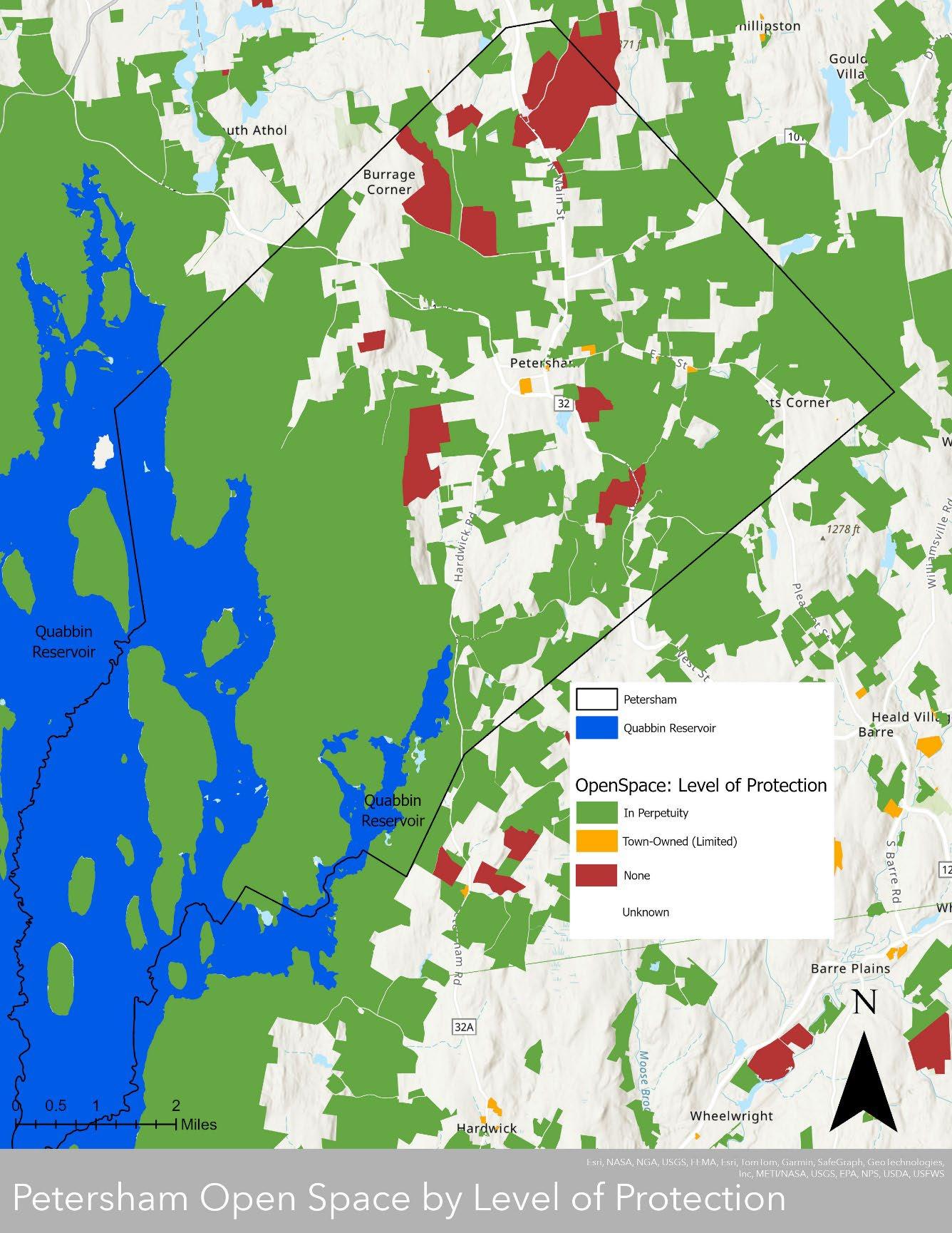
Due to the amount of land protected in perpetuity, much of Petersham is unable to be developed and prime forestland and wildlife habitat can thrive. A top priority of Petersham residents regarding ongoing conservation efforts is to make sure those forests and rare species habitat are connected and allow for wildlife corridors through town and the region. Sources: MassGIS Data: Protected and Recreational OpenSpace, MassGIS Census Towns, MassDEP Hydrography (1:25,000)
Section 5 Petersham 2024 OSRP pg. 89
Table 5-3 Protected in Perpetuity Parcels
Anderson WPR 13.33
Babbitt Wildlife Sanctuary 53.74
Baird & Howell WPR 32.45
Bassetts Corner Conservation Area 19.13
Brooks Woodland Preserve
Brooks Woodland Preserve CR 21.83
Bryant WPR 77.25
Buell WPR 25.59
Butterworth WPR 93.85
Caouette 2 WPR 32.94
Caouette WPR 34.18
Carter Pond WCR
Carter Road CR
Carter Road CR
Casey/Wilder CR 7.22
Chimney Hill Farm LLC WPR 587.54
Chivian & Jacobson WPR 17.39
Clark & Scoufopoulos 2 WPR 18.87
Clark & Scoufopoulos WPR
Clark WPR
Coe WPR
Connor Pond
Coolidge WPR
Coolidge WPR
Davenport Pond
Davis CR
Day & Smith & Brannon WPR
Day & Smith & Brannon WPR
Day Family Trust WPR
Dickson WPR
Ewing WPR 80.90
Federated Women’s Club State Forest
Feldman CR
Finneran-DeBarbieri WPR 5.46
Finneran-DeBarbieri WPR 5.86
Flye CR 19.96
Foye 1 WPR
Foye 1 WPR
Gross Farm
Petersham 2024 OSRP pg. 90
Section 5
SITE NAME ACRES
696.08
107.28
18.49
82.75
26.53
173.26
45.62
30.48
38.56
134.49
80.70
672.65
9.95
20.74
9.50
55.16
995.48
103.95
56.04
96.61
18.78
210.35
88.06
Gross Farm
Harvard Forest
Harvard Forest 2 WPR 647.85
Harvard Forest CR 104.57
Harvard Forest CR 22.23
Harvard Forest WPR 119.53
Hellen WPR 12.58
Hellen WPR 2.75
Hutchinson & Jule WPR 148.47
JB & T Family Limited Partnership WPR
Johnson CR
King Farm CR
Lee/Briggs Lot CR 55.44
Levine & Palin WPR
Lockesmith CR 7.48
Lockesmith WPR
Lockesmith WPR
Lockhart & Block WPR
Lundquist 2 WPR 14.17
Lundquist 3 WPR 23.40
Meixsell WPR 6.13
Mountain Bay Foundation WPR 7.58
North Common Meadow 23.16
North Common Meadow 2.21
Papoyan and Bisharyan WPR
Petersham Country Club CR
Petersham Land Conservation Trust CR 11.21
Petersham State Forest
Petersham Town Common
Petersham Town Common
Petersham Town Forest
Petrie WPR
Phillipston WMA
Pope WPR
Popple Camp WMA
Quabbin Reservoir Watershed
Raccoon Hill WCR 20.23
Raccoon Hill WMA 72.71
Ricard WPR 59.57
Rubin WPR 85.44
Rutland Brook Wildlife Sanctuary
Selden 2 WPR 19.92
Selden 3 WPR
Selden 3 WPR
Selden WPR
Selden WPR
Sinclair CR
Petersham
OSRP pg. 91
Section 5
2024
36.68
231.54
101.57
42.70
20.45
23.14
73.87
40.05
175.15
480.86
0.77
0.82
92.21
32.68
925.57
26.85
590.22
12548.91
705.08
84.27
18.22
242.92
22.54
23.72
Two
Two
Section 5 Petersham 2024 OSRP pg. 92
Street Conservation Area 24.73 Sputtermill Pond Access 60.55 St Mary and St Scholastica CR 150.14 Sunset Lane CR 34.74 Swift River CR 3.91 Swift River CR 63.41 Swift River Reservation 427.13 Tom Swamp Road CR 127.49 Town Forest 20.57
Mile Landbridge 159.52
South
Two
Mile Landbridge 20.18
Mile Landbridge 289.21
Horse Lane Conservation Area 86.28 Woolsey CR 175.11
Trust WPR 187.99 Total Acres 24757.36
White
Yggdrasil
Map 5-3: Chapter 61 Lands and Conservation Restrictions
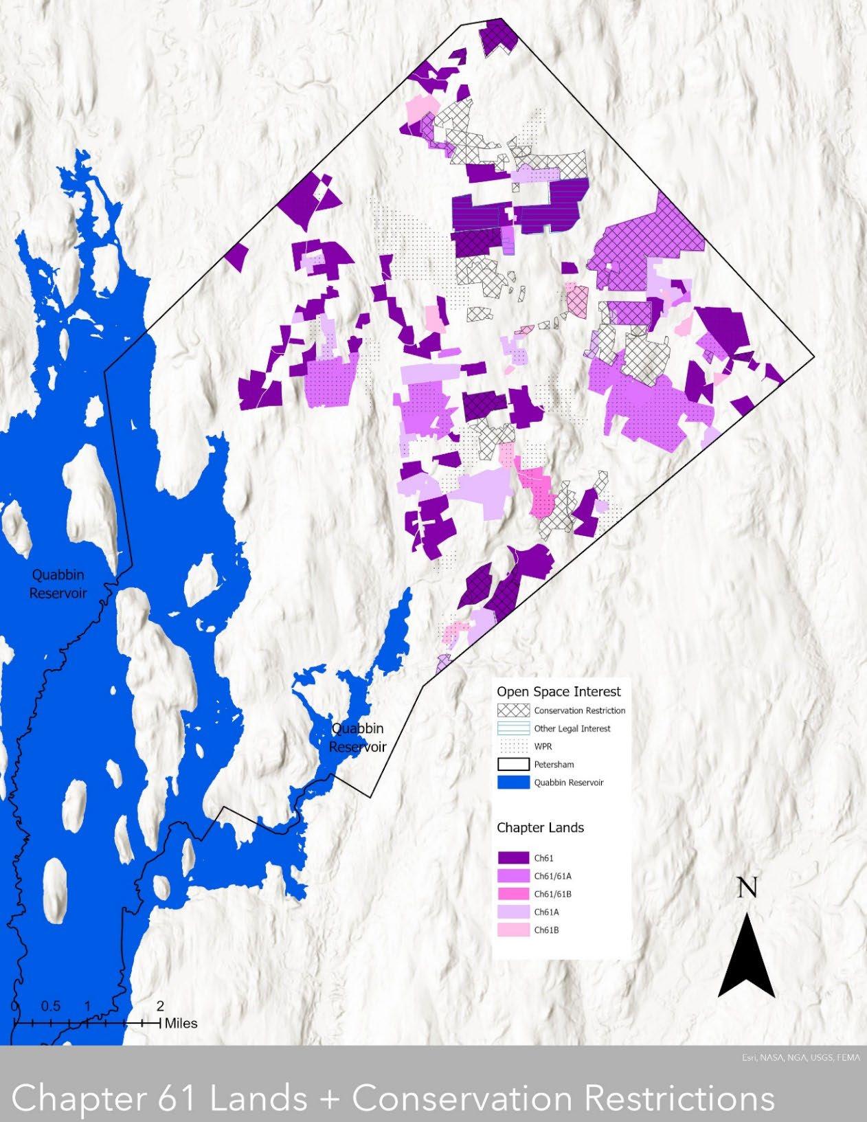
Enrolling in Chapter 61, particularly 61 and 61A for forestry and agricultural management, are popular conservation approaches in Petersham. While these lands are protected while enrolled in Chapter 61, protection status can change with new ownership or if the current owner decides to convert uses. Therefore, these parcels should be considered for future protection if they coincide with conservation priorities, particularly those related to preserving or promoting contiguous habitat. Some Chapter 61 lands have conservation restrictions (shown with hatch marks) and are protected in perpetuity. Sources: Petersham Assessors Office list of Chapter 61 lands, MassGIS Data: Protected and Recreational OpenSpace, MassGIS Census Towns, MassDEP Hydrography (1:25,000)
Section 5 Petersham 2024 OSRP pg. 93
Table 5-4 Chapter 61 Parcels
Section 5 Petersham 2024 OSRP pg. 94
MAP PARCEL TAX PARCEL ID CLASSIFICATION ACRES 201_6_0 6 Ch61A 3.2 201_8_0 8 Ch61A 5.65 201_10_0 10 Ch61A 22 201_12_0 12 Ch61A 12.7 201_14_0 14 Ch61A 7.4 201_69_0 69 Ch61/61A 7.83 201_70_0 70 Ch61/61A 4.16 401_3_0 146 Ch61 11.43 401_7_1 150 Ch61 1.65 401_8_0 151 Ch61 28.11 401_9_0 152 Ch61 27.31 401_11_0 154 Ch61 23.96 401_21_0 164 Ch61 11 401_22_0 165 Ch61 72 401_34_0 177 Ch61 22 402_13_0 189 Ch61 32.42 402_14_0 190 Ch61 1.71 402_16_0 192 Ch61 10.39 403_2_0 247 Ch61 11.1 403_12_0 257 Ch61B 23 403_13_0 258 Ch61B 70.2 403_14_0 259 Ch61 20 403_15_0 260 Ch61/61A 58 403_22_0 266 Ch61 70.5 403_61_0 305 Ch61A 48 406_21_0 354 Ch61 21 406_23_0 356 Ch61B 8.5 406_25_0 358 Ch61B 62.18 406_32_0 365 Ch61/61A 596 406_34_0 367 Ch61/61A 103 406_35_0 368 Ch61 43.3 406_36_0 369 Ch61A 36.4 406_37_0 370 Ch61A 21 406_39_0 372 Ch61B 6.29 406_40_3 373 Ch61A 8.6 406_47_0 380 Ch61/61A 5 406_48_0 381 Ch61/61A 5.9 406_49_0 382 Ch61/61A 1 406_50_0 383 Ch61/61A 1.9 407_36_0 420 Ch61/61A 19.5 407_37_0 421 Ch61 132.5 407_39_0 423 Ch61 166.5
Section 5 Petersham 2024 OSRP pg. 95 407_43_0 427 Ch61 291 407_44_0 428 Ch61A 1.02 408_1_0 471 Ch61 0.33 408_2_0 472 Ch61 26.08 408_23_0 493 Ch61 17 408_24_0 494 Ch61 7.6
495 Ch61 4.12 408_26_0 496 Ch61 5.13 408_40_0 509 Ch61 6.6 408_41_0 510 Ch61 82 408_44_0 513 Ch61 19 408_46_0 515 Ch61A 13.5 408_47_0 516 Ch61A 4 408_48_0 517 Ch61B 0.12 408_49_0 518 Ch61 9.25 408_50_0 519 Ch61 6.92 408_52_0 521 Ch61 34.54
535 Ch61A 5.6 408_67_0 536 Ch61 35 408_70_0 539 Ch61 48 408_72_0 541 Ch61 28 408_73_0 542 Ch61 50 408_74_0 543 Ch61 1.54 408_89_0 558 Ch61 3.1 408_90_0 559 Ch61 22 411_8_0 568 Ch61 22.54 411_15_0 575 Ch61/61A 232 411_16_0 576 Ch61A 1 411_16_1 577 Ch61A 34.1 411_17_0 580 Ch61 47.15 411_21_0 584 Ch61 54.9 411_22_0 585 Ch61 110.46 411_28_0 591 Ch61 18.1 411_29_0 592 Ch61 8.6 411_30_0 593 Ch61 12.9 411_31_0 594 Ch61A 14.4 411_36_0 599 Ch61 9.86 411_42_0 605 Ch61A 12.65 411_44_0 608 Ch61A 7.4 411_49_0 613 Ch61 16.87 412_1_0 620 Ch61B 10 412_22_0 641 Ch61 1.2
651 Ch61B 5.3
408_25_0
408_66_0
412_32_0
20
412_37_0 656 Ch61
Ch61 94
412_40_0 659
412_46_0
412_78_0
412_79_0
412_81_0
Section 5 Petersham 2024 OSRP pg. 96
665 Ch61 97.1 412_54_0 673 Ch61 25.3
683
15
156
412_64_0
Ch61/61A
412_70_0 689 Ch61/61A
88
412_77_0 696 Ch61A
697
13.53
Ch61
698 Ch61 12
700 Ch61 3.8
701 Ch61 13.5 412_86_0 705 Ch61 65.5 412_88_0 707 Ch61B 44 413_3_0 710 Ch61A 8.29 413_12_0 720 Ch61A 2.5 413_16_0 724 Ch61B 22.5
727
160
730
51.5
733 Ch61 3.63
734 Ch61 1.5 413_27_0 735 Ch61 1.5 413_28_0 736 Ch61 5.37 413_31_0 739 Ch61B 10.3 413_38_0 746 Ch61 85 413_52_1 760 Ch61/61A 0.86 413_58_0 766 Ch61/61A 59.3 413_66_0 774 Ch61A 24 414_1_0 780 Ch61 1.51 414_4_0 783 Ch61 19.37 414_8_0 787 Ch61 10.19 414_13_0 792 Ch61 23.3 414_28_0 807 Ch61 33.7 415_1_0 811 Ch61A 7.7 415_2_0
6.5 415_3_0 813 Ch61A 12.2 415_14_1 825 Ch61A 9.28 415_16_1 828 Ch61A 4.17 415_17_0 829 Ch61 108.73 416_11_0 861 Ch61/61B 5 416_12_0 862
6.7 416_16_0 863
32 416_17_0 866
36
73.15
124.88
32
906 Ch61/61A 25
909 Ch61 159
412_82_0
413_19_0
Ch61
413_22_0
Ch61/61A
413_25_0
413_26_0
812 Ch61A
Ch61/61B
Ch61/61B
Ch61/61B
416_29_0 878 Ch61A
416_47_0 896 Ch61A
416_49_0 898 Ch61B
416_57_0
416_60_0
416_66_0 913 Ch61
416_80_0 926 Ch61
416_82_0 928 Ch61
416_88_0 934 Ch61A 5.51
416_89_0 935 Ch61
416_99_0 945 Ch61A
986 Ch61
418_28_0 987 Ch61
418_29_0 988 Ch61A
402_15_0 1084 Ch61
Section 5 Petersham 2024 OSRP pg. 97
37.97
38
51.49
10.71
416_71_0 918 Ch61A
416_72_0 919 Ch61
21.24
36.56
13.35
8.1 416_101_0
7.48 416_105_0
71 418_2_0
31.5 418_26_0
127 418_27_0
28.9
15.93
416_100_0 946 Ch61A
947 Ch61A
951 Ch61/61A
963 Ch61
985 Ch61
17
14.16 418_35_0
3.69 418_36_0
Ch61B 3.72 418_37_0
3.45 418_55_0
12.35 418_56_0
Ch61A 5.1 418_58_0 1017 Ch61 84 418_61_0 1020 Ch61 0.8 418_62_0 1021 Ch61 8 418_74_0 1033 Ch61 12.3 420_5_0 1049
6.15 420_10_0
15.21
5.38
21.57
31 406_40_1 1064 Ch61A 20.16 406_40_2 1065 Ch61 18.5 413_53_0 1071 Ch61/61A 531 412_80_0 1073 Ch61 10.5 416_87_0 1076
43.45 416_78_0
83.1
10.22
418_31_0 990 Ch61B 6.81 418_34_0 993 Ch61B
994 Ch61B
995
996 Ch61B
1014 Ch61
1015
Ch61A
1054 Ch61A
420_12_0 1056 Ch61A
201_76_2 1061 Ch61
416_13_0 1062 Ch61/61B
Ch61A
1077 Ch61
401_7_0 1082 Ch61
401_14_0 1083 Ch61 13.5
Total Acres 6573.51
88.12
Section 5.2: Recreation Lands
Recreation and community gathering are important to residents of Petersham. Due to the large amount of open space in town, there are several opportunities for facilities-based “active” recreation and nature-based “passive” recreation.
Active Recreation
Soccer and baseball programs for Petersham residents in grades K-6 are conducted as part of the regional school district, which includes Barre, Hardwick, Hubbardston, New Braintree, and Oakham. Basketball for grades 1 to 6 is organized locally by volunteers, who collect a small fee for each participant to pay for use of the school gymnasium for games. All sports for grades 7 to 12 are organized and provided through the Mahar Regional School, which offers more extensive sports fields and teams for its middle school and high school students.
Most of the sports and recreation programs in Petersham (except for the Mahar teams) are initiated and managed by volunteers, without financial assistance from the Town. While the school mows the grass on the fields at the Center School, volunteers are responsible for most other maintenance. In years past, the Town spent $2,500 to install a new fence around the little league field to bring it up to regulation standards.
Active Recreation Facilities
a. Petersham Center School, limited protection, public access, owned by the Town of Petersham. Recreation facilities include a little league field, softball field, soccer field, and indoor gymnasium. Outside of school hours there are organized pickleball and basketball games for adults.
b. Petersham Curling Club, no protection, public access
c. Petersham Gun Club, no protection, limited public access.
Passive Recreation
Petersham residents are passionate about passive recreation, such as hiking, walking, and swimming. The town is known for offering excellent hiking trails, due in large part to the scenic views afforded by ample conservation lands.
The majority of open space lands that are owned by the state, Town, or land trusts are open to the public for recreational use. All DCR-owned properties in town (except for the islands in the Quabbin Reservoir) are open to the public.
Much of the conserved lands in town contain trails for non-motorized recreation such as hiking, cross-country skiing, snowshoeing, and, in some instances, mountain biking. Official mapped hiking trails are available at Harvard Forest, the Federated Women’s Club State Forest, the Petersham State Forest, the Swift River Reservation, White Horse Lane Conservation Area, Rutland Brook Wildlife Sanctuary, Brooks Woodland Preserve, and the North Common Meadow.
Many of the trails in Petersham are mapped by the managers of the individual properties, but there is no coordinated townwide trails map. In addition to these trails on public and nonprofit
Section 5 Petersham 2024 OSRP pg. 98
lands, there are some “unofficial” trails on private property. In some instances, these trails are used only by the landowner; in other cases, neighbors and others use them as well.
Since motorized activities such as snowmobiling and riding all-terrain vehicles are generally prohibited on public and nonprofit lands, these activities are only supposed to occur on private trails.
In addition to trail-related activities, there are numerous other passive recreation opportunities available in Petersham, such as hunting, fishing, swimming, picnicking, camping, and boating.
Section 5 Petersham 2024 OSRP
pg. 99
Map 5-4: Trails

This is a combination of existing trail maps for Petersham, from different sources. While hiking is the most popular recreational activity in town, for residents and out-of-towners alike, a comprehensive guide and map for hiking and other trail activities in town does not exist. Sources: MassGIS Data: Hiking Trails for NextGen 911, MassGIS Data: Tracks and Trails, MassGIS Data: Department of Conservation and Recreation Roads & Trails, Petersham Trail Inventory from the Montachusett Regional Planning Commission, MassGIS Census Towns, MassDEP Hydrography (1:25,000)
Section 5 Petersham 2024 OSRP pg. 100
Map 5-4 shows that there are trails in the major conservation areas in town and they are welldispersed throughout town. One activity from the community engagement meeting held on March 2, 2024, asked residents to put dots in areas where they would like additional trails in order to expand hiking opportunities and/or to connect existing conservation areas; a photo of this activity is included below.
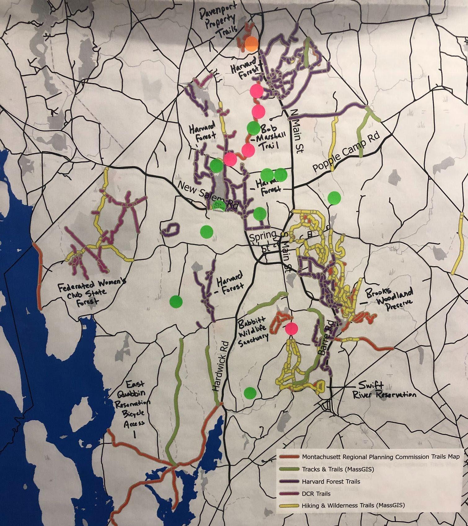
Section 5 Petersham 2024 OSRP pg. 101
Section 5.3: Regional Connectivity of Open Space Lands
Regional connectivity of intact forest, wildlife habitat, and wildlife corridors is a priority concern of Petersham residents. In years past, local organizations made it a priority to create a contiguous large-scale network of conservation lands stretching from the Quabbin Reservoir to the New Hampshire border, providing protected habitat for the area’s native species. This vision began to take form in the shape of a large “donut” of conservation lands encircling Athol and Orange; conservation areas were secured along the northern section of this “donut” in Warwick and Royalston and various agencies and organizations involved in land conservation in the north Quabbin region formed the North Quabbin Regional Landscape Partnership, which is part of Mount Grace, to coordinate their efforts.
More recently, Mass Audubon has collaborated with several partners and landowners and is seeking to permanently protect 973 acres in the vicinity of Rutland Brook Wildlife Sanctuary in the town of Barre, adjacent to Petersham. As of March 2024, they are raising the funds to complete the project.
Section 5 Petersham 2024 OSRP pg. 102
Map 5-5: Open Space by Level of Protection – Regional Context
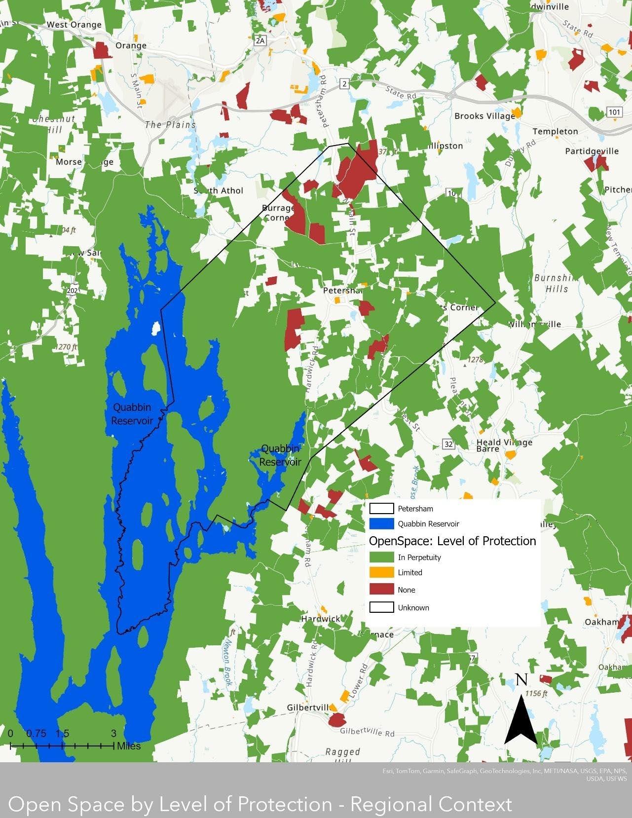
This zoomed out map shows areas of contiguous protected open space, particularly around the Quabbin Reservoir, but also along the eastern edges of Petersham. Local conservation organizations have made it a priority to consider regional connectivity when pursuing protection of specific parcels; these large, undeveloped patches of land can foster greater wildlife habitat and ecosystem function. Sources: MassGIS Data: Protected and Recreational OpenSpace, MassGIS Census Towns, MassDEP Hydrography (1:25,000)
Section 5 Petersham 2024 OSRP pg. 103
The Fisher Museum at Harvard Forest offers information on forest ecology, landscape history, and land conservation and management It is also home to a series of 23 dioramas which show changes to the landscape sine the colonization of unceded Nipmuc territory.
5 Petersham 2024 OSRP pg. 104
Section
Section 6
Community Vision
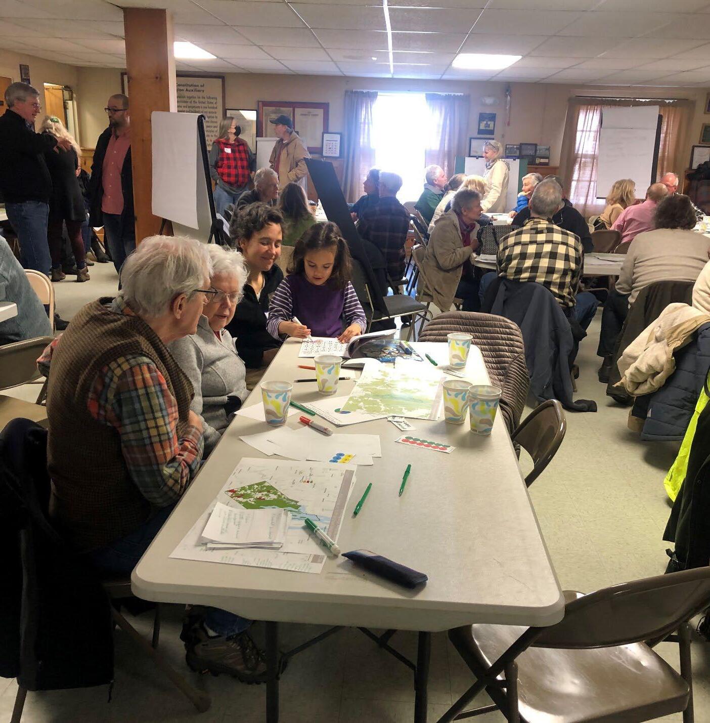
Section 6 Petersham 2024 OSRP pg. 105
Community engagement meeting in Petersham Town Hall, February 3, 2024
A. Description of Process
Petersham’s first Open Space and Recreation Plan was written in 2003 with input from residents, guidance from the Petersham Ad Hoc Planning Committee, and technical assistance from Daylor Consulting Group. The accompanying but never-formally-adopted 2004 Master Plan, also prepared by Daylor and the Ad Hoc Planning Committee, influenced and was sometimes referenced by subsequent planning documents. Those documents include the 2005 Town of Petersham Affordable Housing Plan prepared by the Petersham Affordable Housing Task Force, and the 2008 Petersham Reconnaissance Report prepared by the Massachusetts Department of Conservation and Recreation. The next OSRP was written in 2014. It was based on the 2004 OSRP and 2008 Petersham Reconnaissance Report and incorporated public input from two Special Public Meetings. The 2016 Nichewaug Inn Market and Feasibility Analysis prepared by Concord Square Planning and Development, Inc. followed. The Vision Statement included in the 2014 OSRP is nearly identical to the one in the 2004 Master Plan.
As preparation for drafting a new OSRP, Petersham’s Open Space and Recreation Committee conducted a survey of town residents. According to the Open Space and Recreation Committee:
The first step of public engagement in the Open Space & Recreation Plan update process began with a public survey prepared by the Open Space & Recreation Committee, which ran from Monday, October 23 until Friday, December 1, 2023. The public survey was available online at SurveyMonkey and as printed paper surveys. The online survey was linked at the Town website, in articles in The Barre Gazette and The Athol Daily News, in weekly posts at the Petersham Alert Network on Facebook and publicized through regular emails. The 595 printed surveys were mailed to every residential mailbox and PO Box in Town. Additional copies of the printed survey and deposit boxes were available at Petersham Memorial Library, Town Hall, Town Business Office, The Country Store, Quabbin Woods Restaurant, and the Petersham Package Store. Paper surveys were hand delivered to the Petersham Center School. Flyers were posted around town at local churches, civic buildings, local businesses, and at the post office. Surveys were distributed at the Town Scarecrow Contest and Halloween on the Common. We also spread news about the survey by word of mouth.
Survey questions assessed residents’ interest in and reasoning for protection of open space as well as their recreational interests. In a town with a population of 1,194 people in 461 households there were 209 survey response submissions.
In January 2024, a Core Team of Petersham residents, including members of the Open Space and Recreation Committee, Conservation Commission, Board of Registrars, Zoning Board of Appeals, and Cultural Council, met with three graduate students from the Conway School to begin working on the updated OSRP. As part of the process, the Core Team provided logistical support to the Conway students for two community engagement meetings. The agendas and results of these meetings can be found in Appendices B and C, respectively.
The first meeting was conducted as an in-person/Zoom hybrid on February 3, 2024. The meeting was attended by seventy-one residents in person and eleven by Zoom. There were three entry activities. A sign-in sheet gathered demographic information, a poster sought clarification of Survey Question #1, regarding the importance of the Town acquiring versus conserving open
Section 6 Petersham 2024 OSRP pg. 106
space, and an open response question simply asked, “What brought you here today?” The formal meeting began with the Core Team summarizing the purpose of the OSRP and actions taken to date to address the 2014 OSRP’s goals and objectives. The Conway students followed with a brief overview of the survey results. The Conway team then introduced an exercise wherein residents rated the different parts of a modified 2014 Vision Statement (modified slightly to eliminate redundant language and reference to the already-preserved Country Store) for level of agreement and provided alternate visions. This was followed by individual and group efforts to identify the greatest concerns and desires for Petersham regarding recreation and conservation.
The Conway team conducted a Works-in-Progress presentation at the Conway School in Northampton on February 23, 2024. The students presented contextual analysis of the town, including a summation of the survey; rephrasing of the vision statement; and analysis of the ecology, recreation opportunity, and development concerns. They also presented some potential recommendations regarding trail connectivity and planning related to development. These noncomprehensive presentations were designed to solicit input about the process from a panel of guest reviewers as a part of the educational experience for the Conway students. The Core Team was invited to attend, and the video of the presentation was posted on the Town of Petersham website. The core team informed residents about the posting by email. Some residents provided feedback based on the contents of the recording.
The second community engagement meeting, also conducted as an in-person/Zoom hybrid, was held on March 2, 2024. The meeting was attended by 29 residents in-person and 6 households by Zoom. It began with a presentation which described the process and progress to date. A variety of activity stations were designed to solicit further feedback on the nature of the community’s vision and goals, as well as what open spaces are of highest interest for conservation or recreation.
Section 6 Petersham 2024 OSRP pg. 107
Statement of 2024 Open Space and Recreation Goals
The results of the public survey, community engagement meetings, and interactions with the residents of Petersham have led to the following Vision Statement and accompanying goals for the 2024 OSRP:
Petersham is a community committed to conserving its open spaces where people and nature thrive together and to offering recreational opportunities to its residents and visitors alike while providing an affordable and financially sustainable path forward.
1. Petersham will retain its beauty, unique sense of place, and rural character by protecting the health and integrity of its natural assets, including but not limited to its air, drinking water, wetlands, soils, scenic views, working farms, fields, and forests, large blocks of connected forestland, and the diversity of its native flora and fauna.
2. Petersham will enhance the quality, variety, and accessibility of its open spaces and recreational offerings for the health, well-being, safety, and enjoyment of all residents and visitors.
3. Petersham will increase climate-resilient land practices and active community stewardship of its open spaces, public byways, and private lands.
4. Petersham will improve communication among Town departments, committees, and residents to increase public awareness about open space access, inclusive cultural and recreational uses, land conservation, and stewardship.
Section 6 Petersham 2024 OSRP pg. 108
Section 7 Analysis of Needs
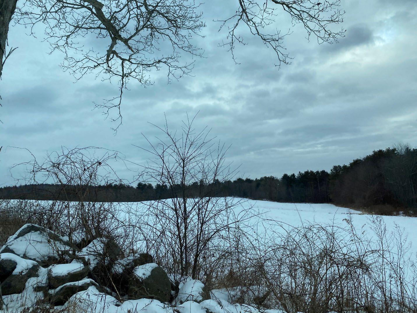
Section 7 Petersham 2024 OSRP pg. 109
Fields and Forests of Petersham, Massachusetts.
Petersham’s needs have been assessed by means of the 2023 Open Space and Recreation Survey, two community engagement meetings in February and March of 2024, and discussions in person and over Zoom with Petersham’s various boards, commissions, and residents. Results from the survey and meetings can be found in Appendices A and C.
Many conditions in Petersham are similar to those described in the 2014 OSRP. There are some notable changes, such as zoning and back lot amendments to the Zoning By-Laws, demolition of the Nichewaug Inn, and the conservation of more than one thousand acres in Petersham.
A. Summary of Resource Protection Needs
Wildlife and Critical Habitat
A remarkable amount of core and critical habitat is in permanent conservation, with additional lands in temporary conservation agreements. Areas lacking permanent protection are all in the northeastern half of town and tend to follow or branch off from the major roads. There are pockets in the northern and eastern corners of town, and swaths along Route 32 heading north from the town center, between Routes 32 and 32A heading south from the town center. A large swath stretches from the northeastern edge of Petersham (near Athol), crosses Route 122 and juts into the state DCR land (See Map 5-2: Open Space by Level of Protection). Some of the lands lacking permanent protection are under temporary Chapter 61 protection (see Chapter 5-3: Chapter 61 Lands and Conservation Restrictions). Informing landowners and managers about the best conservation and protection methods could help protect these valuable ecosystems further.
Over 90% of survey respondents indicated a desire to protect environmentally sensitive areas in Survey Q2, a sentiment well reflected at community engagement meetings. And 92% indicated a desire to protect wetlands. The broad forested landscape is dotted with wetlands and waterways, which are critical habitats for numerous plant and animal species (See Maps 4-8 and 4-9). When vernal pools are certified by the Massachusetts Natural Heritage and Endangered Species Program, those pools may receive jurisdictional protection under Wetlands Protection Act regulations. It is therefore important to identify uncertified pools, especially those in otherwise unprotected areas, in anticipation of submitting them for certification (See Map 4-10).
Residents have expressed a concern about the proliferation of non-native invasive species, both flora and fauna, in Petersham’s open space. Non-native invasives can outcompete natives that have co-evolved to support each other and thereby have wide ranging impacts on an ecosystem. There is an added concern that climate change may exacerbate their proliferation by expanding their range to include Petersham and in the ecosystem gaps created by native species die-back due to adverse climate conditions or pests.
Connectivity and Wildlife Corridors
Over 90% of survey residents indicated a desire to protect unfragmented habitats and wildlife corridors. There is a considerable amount of connectivity between habitat areas within Petersham and with areas outside of Petersham because of the large amount of permanently protected land Chapter 61 lands contribute significantly to habitat connectivity although these lands are often not permanently protected. Land lacking permanent protection in town takes the form of a figure-eight with the union of the two loops being the center of town These areas coincide with
Section 7 Petersham 2024 OSRP pg. 110
the state roads. There are additional areas without protection spreading along East Street. These areas coincide with breaks in forest cover and habitat blocks, generally coinciding with human habitation (See Map 5-2: Open Space by Level of Protection).
If increased development comes to Petersham, current zoning rules may cause development to fill out the roadsides even further. If houses and lawns line the entire length of the roadside, they would further fragment the forest and habitat blocks, thereby reducing connectivity and obstructing wildlife corridors. Fortunately, there are mechanisms in the zoning code which enable greater density of housing if some of the area with road frontage is conserved, preventing development from occurring along the entire length of the roadside. This might create corridor bridges around the swaths of development. There are also conservation requirements for subdivisions and other tools to enable denser housing which would result in more protected space while allowing for increased housing. It is unclear if there is a wide-spread awareness of these mechanisms or interest on the part of developers in pursuing them. Without their use, however, there is the possibility for further interruption of connectivity and wildlife corridors with current zoning.
The illustration on the left shows the potential effect of development with minimum frontage and lot size requirements, with developed lots lining the road potentially having a negative effect on habitat connectivity. The illustration on the right shows the potential effect of concentrating development into a smaller area and conserving land around it to preserve a degree of connectivity
Farming and Forestry
There is widespread interest in conserving farming and forestry in Petersham. Survey Q2 indicates that 88% of survey respondents feel that protecting farmland is important and 89% feel that protecting forests is important. Individual discussions with residents evidenced varying and interrelated reasons for this interest. Farmlands and forests can both provide ecologically valuable habitat and contribute to Petersham’s rural character by way of scenic vistas and a nod to its post-colonization agricultural past (See Map 3-2: Land Cover in Petersham, MA 2016 and Map 4.3: Farmed Prime Soils).
Agricultural lands such as pastures and hayfields, because of their periodic disturbances, can provide habitat to species which need early successional landscapes to flourish. Because many of Petersham’s agricultural lands are pastures and hayfields, conservation of these areas might be doubly effective by conserving both habitat and rural character. Residents have also expressed a desire for locally produced food. Conserving agricultural land, in addition to staving off development, can make it financially accessible to prospective farmers, thereby enabling its continued use for food production. Farms and forests alike contribute to the local economy.
Section 7 Petersham 2024 OSRP pg. 111
Some residents have also expressed an impulse to protect these industries because doing so protects the livelihoods and lifestyles of their neighbors.
Residents have expressed a concern with clear-cutting as a forestry practice because of valid concerns about the negative effects of clear-cutting by way of increased erosion and reduced carbon sequestration but forestry practices in town are almost always utilizing selective cutting. The specific instances of clear-cutting that residents have referred to have typically preceded some form of development.
The 2016 Petersham Farmland Inventory prepared by Mount Grace Land Conservation Trust provides an in-depth inventory of active farming activities as well as a rubric for prioritizing conservation of agricultural parcels. This rubric could be adapted to explore other conservation interests, such as wildlife corridor protection. The town could also create an all-encompassing rubric which prioritizes conservation actions informed by a range of interests (e.g., prime farmland, sensitive habitat, or connectivity).
Ecosystem Services: Water, Air, and Soil Quality
Residents are also concerned about the impacts of human uses on the natural resources they depend on. Survey question Q2 and feedback at both community meetings indicate residents have a very high interest in protecting Petersham’s water and wetlands. Concern about the air quality was nearly as high.
Towns with small populations and low budgets are not often able to build a wastewater system or municipal water supply in large part because of the cost, amplified on a per person basis by the low population density in a town like Petersham. Water comes from wells and wastewater is dispersed through septic systems, even for larger buildings like the public school. If appropriate systems are not installed properly, with due consideration to development density, soil type, slope, groundwater health, and proximity to nearby surface water, the systems can fail and threaten to contaminate nearby water, including wells, surface water, and everything downstream from the source of contamination. The densic layers and poor percolation of most of Petersham’s soils can increase this possibility, as can aging systems (See map 4.2 Soils and Geologic Features: Wet Soils). Major rain events, which have been more prevalent in recent years because of shifting climate patterns, can also increase the risk of contamination. The reliance on wells and the need to protect the quality of the Quabbin raise the stakes. Exploration of new septic technology may provide better water protection and more flexibility in development patterns. The benefits would extend to vernal pools, wetlands, ponds, and the streams that feed the Quabbin.
Non-point-source pollution entering the waterways via storm drains or run-off from roads without drains is a particular concern voiced by residents. As mentioned in Section 3, this can negatively impact habitat and water quality in the Quabbin. As discussed in Section 4, PFAS have been detected in Petersham.
Air quality concerns typically were voiced in terms of carbon-sequestration. While many residents want to protect forestry practices, which can involve logging, they want to preserve wooded areas because of their major carbon sequestration capacity.
Section 7 Petersham 2024 OSRP pg. 112
Soil health concerns were evidenced by occasional references to pesticide use. Pesticides can have adverse effects on wildlife and natural ecosystems as well as humans. There is also a possibility that some prime agricultural soils have been adversely affected by human habitation, whether through soil disturbance, compaction, or contamination (such as lead).
Trails and Related Passive Recreation (See
Map 5-4:
Trails)
Walking and hiking were the most popular recreational choices for Petersham residents responding to 2023 Survey Q8. Other popular activities which take place on Petersham’s trails are birdwatching, dog-walking, cross-country skiing, snowshoeing, mountain biking, jogging/running, snowmobiling, and ATV-use, although many use these activities are restricted at some trail locations. There are differing opinions about trail access for motorized vehicles. The purposes and rationales for use include recreation, transportation, and precedents of prior access. Arguments against the use of motorized vehicles include noise pollution, air pollution, degradation of trails, and safety concerns. Some residents would like to see increased access for motorized vehicles while others would like to ban the activity within throughout the town. Individuals may have different opinions about different types of vehicles.
Respondents to Survey Q9 generally (156 out of 203, approximately 80%) claimed to be satisfied with the walking paths and hiking trails in Petersham but comments throughout the survey and at the community engagement meetings belie this sentiment. Residents have indicated desires for increased trail connectivity within town and to trails outside of town, improved accessibility for individuals with impaired mobility, safer interactions with traffic, and increased awareness and accessibility to the trail systems. Some of these needs may be complicated by the proximity of trails to protected or sensitive habitat areas and the potential impact of increased human activity, unwillingness of landowners to grant access to their land for trail connections, and land-owners/trail-tenders who might have limited knowledge of trail building or maintenance; limited resources in the form of labor, equipment, and money; or limited time or desire to engage in trail building or maintenance.
Some residents have also expressed concerns about perceptions of trails as having a nonwelcoming or unsafe appearance, especially for individuals who identify as BIPOC or female. It is possible that making public trail heads more obvious, increasing accessibility, and better trail maintenance could help to change these perceptions.
Certain trails have been mentioned as having specific needs, sometimes linked to other needs at the trail location. Trails which residents have indicated as needing attention include Bob Marshall Trail (continued construction and maintenance), Babbitt Wildlife Sanctuary (improved parking, trail construction, and maintenance), and Davenport Pond Conservation Area (trail construction, structure removal, clearing trees from the dam, repair or removal of the dam) These locations warrant further analysis of needs and possible intervention.
Sidewalks which residents have indicated as needing improvement include the town center, Spring Street, and the upper portion of Hardwick Road (parts of the “Old Maids Mile,” especially popular with older residents who tend to live in the center of town).
Section 7 Petersham 2024 OSRP pg. 113
Hunters and hikers can sometimes be at cross purposes. Only twenty-three of two-hundred-andnine survey respondents replied that they hunt in Petersham, but comments in the survey and at the community engagement meetings indicated strong opinions about hunting, most often about deer hunting. There are various arguments to be made for and against, but according to the Division of Fisheries and Wildlife, “when deer numbers exceed what the habitat can support, forest health can be severely degraded and negatively impact other animals and plants” (Deer Management) Short of re-introducing natural predators, hunting can help protect Petersham’s forests. Hunters tend to prefer not to hunt near established hiking trails because hikers can scare away game. Hikers would like to see more trail connectivity, and more trails might mean fewer areas suitable for hunting. An inventory of lands where hunting is allowed would raise awareness of these areas. The town might also conduct an assessment for their suitability for hunting and identification of additional or alternative locations
B. Summary of Community’s Needs
Rural Character
Rural character is of extreme importance to Petersham’s residents. In the survey, it ranked slightly (1-2%) below the main topics listed in 7A. Summary of Resource Protection Needs, but rural character is brought up in almost every conversation relating to open space in Petersham. Rural character in Petersham is defined as much by its open space as by its more obviously human-made components (e.g., historic buildings in a small town center, moss- and lichencovered stone walls, and aging cemeteries) and the residents of Petersham are proud of the agricultural, forested, and conserved landscapes (See Map 4-4: Unique Features). Comments from the survey and community engagement meetings show that residents can have strong adverse reactions when lots are cleared for new homes or other purposes, including logging. Rules that limit back lots and subdivision, push most development to the roads, making development very visible. And most of Petersham’s agricultural land, often prime candidate for development, is along the roads. These circumstances lead to a high possibility that new development will impinge on Petersham’s rural character.
Access for Passive Recreation
The most popular passive recreation activities in town are walking and hiking. These community needs have been addressed in A. Summary of Resource Needs. Residents currently enjoy a wide variety of other passive recreation activities. Survey Q9 concerns satisfaction with recreation resources. The responses suggest that the greatest need for improvements, in order of importance, are indoor recreation spaces and courts for sports; activities for adults and seniors; playing fields and outdoor courts for sports; activities for teens and young adults; boat landing/access to water bodies; activities for children and youth; playground; and sidewalks in the town center. A boat landing/access to water bodies falls firmly under 2023 Statewide
Comprehensive Outdoor Recreation Plan Goal 1.2 (see Appendix E), and access to a swimming area, a relatively high recreation desire based on survey Q8, would fall under SCORP Goal 1.1.
The desire for activities for different age groups is to some degree programmatic as opposed to spatial and may tie into a thread throughout the survey and meeting comments evoking a desire for bringing people together. While there are several indoor gathering spaces in town (Town Hall, the library, churches, school, etc.) which can serve as community gathering spaces there
Section 7 Petersham 2024 OSRP pg. 114
does not seem to be an open-air venue which provides shade and protection from precipitation and might accommodate large crowds and be available without first getting a key. A pavilion was a recurring suggestion which might serve a valuable function for the community and falls under the SCORP Goal 3.3: to support the development of park-like amenities. This could also be a venue for town-wide land-based festivals, fairs, or events to promote eco-tourism
Active Recreation Facilities
There are several active recreation venues in town, such as the Petersham Gun Club, Petersham Curling Club, and Petersham Center School, which offers indoor and outdoor courts and fields as well as a playground. These school facilities are only available during non-school hours and the indoor courts are not always open in non-school hours. The top desire is pickleball or tennis courts. Other interests are a swimming pool, playing fields and courts for team sports, and an outdoor ice-skating rink. Playing fields could host other recreation activities, such as lawn games and kite flying, which saw support from a smaller contingent of residents. The details of these results can be found in the survey and meeting results in the appendices. A study addressing suitable locations and costs might be helpful in deciding whether to pursue these facilities.
Cultural & Historical Heritage for all Peoples
Heritage is our legacy from the past, what we live with today, and what we pass on to future generations – UNESCO
The Nipmuc people, as with many Native populations, have been the subjects of centuries of violent acts that disenfranchised and dispossessed their communities of their Algonquian language, culture, and connection to the land. These processes have been enacted with the intention of eradicating and erasing the presence of Nipmuc people from their lands. The scalp bounties Petersham was founded on, along with slavery, wardship, forced assimilation, and unhonored treaties have been deeply traumatic for generations of Nipmuc people and have given cause for a distrust of the institutions and people which pursued those acts. The results of the 2023 Open Space and Recreation Survey and two community engagement meetings in February and March of 2024 indicate an interest in creating and improving relationships between the residents and Town of Petersham and the Nipmuc people. The relevance to this OSRP lies in the potential of open space and recreation the land itself to serve as a bridge between these peoples.
Recognition of the history between colonizers and their successors and the Nipmuc, as well as the harms inherent in that history, is a crucial step in a relationship. Establishing a Truth Commission would start that process at the Town level. It is also imperative to reaffirm the sovereign rights of the Nipmuc and other sovereign nations which were previously affirmed in treaties and agreements such as the 1727 Treaty of Falmouth, the 1749 Treaty of Falmouth, and the Maritime Crown (Queen Anne) Treaties of 1693 and 1713. These were later reaffirmed by the Commonwealth of Massachusetts in Executive Order No. 126 in 1976 and in 1998 by the Appeals Court of Massachusetts (Wampanoag Fishing Rights - Appeals Court). These Aboriginal treaty rights include hunting, fishing, and gathering rights and exist outside of state regulations.
Section 7 Petersham 2024 OSRP pg. 115
A multitude of post-colonization cemeteries, stone walls, foundations, and cellar holes throughout Petersham’s open space have been mapped by individuals and organizations. A comprehensive map of artifacts should be made, enabling monitoring, preservation, and maintenance as deemed necessary. It may also be necessary to protect the context (e.g., forested landscape or proximity to historic buildings) they are in. Sites of historical or cultural significance should be considered as factors in conservation of land. The historic architecture in the town center is already protected by the Historic District, but an inventory of historic buildings or places which are culturally important or important elements of the viewshed may be candidates for future preservation. Relevant information should be available to explain the importance of these sites. Any such efforts regarding Nipmuc artifacts or heritage should only be with the consent, participation, and leadership of the Nipmuc people.
C. Management Needs, Potential Change of Use
Financial Needs
Based on survey Q9 and community engagement meeting results, residents have greater interest in utilizing already-conserved open space in the town than acquiring more for conservation. There is greater interest in acquisitions or other arrangements which have a specific benefit for the town, such as access to a boat launch or swimming hole, than there is for acquisitions based on the availability or size of a parcel. While residents overwhelmingly support conserving land and are open to acquisitions or conservation strategies which use non-Town funds such as state or federal grants, some residents are concerned about the loss of property tax revenues when land becomes conserved. However, a 2019 UMass Amherst study of fiscal impacts of land use found that “permanent or temporary conservation which reduces property taxes from open space would likely not drastically increase taxes for other types of land” (Murray, Catanzaro). One of the towns in the study was Whately, also a relatively small town which would have the strongest correlation to Petersham.
Table 7-1: Ratio of Revenue to Expenses for Whately Whately
Source: Fiscal Impacts of Land Use in Massachusetts
The Town receives payments-in-lieu-of-taxes (PILOT) from the state for land conserved to protect the Quabbin Watershed. These payments are based on a complex formula which factors in Petersham’s zoning criteria, meaning that changes to zoning requirements such as frontage or lot size could alter the amount of money Petersham receives from the state. The PILOT payments are likely more than the Town would earn from taxes if the land were in private
Section 7 Petersham 2024 OSRP pg. 116
Population
Revenue
Residential $1 : $1.13 Commercial/Industrial $1 : $0.56 OpenSpace $1 : $0.46 Town Overall $1 : $0.98
1,513 Total Town Budget $5,572,091 Zoning Type
: Expenses
ownership and enrolled in any of the Chapter 61 programs because of the associated tax incentives. Clarification around this issue may help the Town identify conservation priorities.
Massachusetts Joint Bill (H.897/S.447), An Act relative to the Quabbin watershed and regional equity, is a piece of proposed legislation seemingly stalled in the Massachusetts legislature. If passed, the bill would raise PILOT payments in the Quabbin Watershed, which could increase Petersham’s budget and ability to engage in future conservation and recreation efforts.
Becoming a Massachusetts Community Preservation Act community would enable the town to apply for matching grant funds for projects involving open space, historic preservation, affordable housing, and outdoor recreation. The town would have to do so by passing a referendum which includes approving a real property surcharge of up to 3%, which would fund the program in Petersham. The abutting town of Phillipston has become a CPA community, as have Templeton, Hubbardston, Shutesbury, Pelham, and Belchertown.
Communication
There is a desire for increased communication regarding multiple facets of open space and recreation, as evidenced by comments in the survey and community engagement meetings. Residents are seeking increased awareness of recreation opportunities especially around open space, both online and at the point of recreation. In the case of passive recreation, they also desire site-specific interpretational materials. Specific sites referred to include Babbitt Wildlife Sanctuary and the Poor Farm.
Whereas many residents are well informed about the financial benefits afforded by Chapter 61 and the Right of First Refusal, many are not. There is a need for better information about these programs. Because the state is considering making changes to the program for greater accessibility for landholders, it is an appropriate time to provide refresher courses. The same can be said of the Community Preservation Act and other conservation tools such as easements and use agreements which may allow access or conservation without removing properties from the tax roll. Residents have also expressed an interest in presentations and workshops about these tools and programs.
There is a need to inform residents and Town personnel of the existing cultural use rights of Indigenous groups in the region. More information about these rights can be found in Massachusetts State Executive Order 126 of 1976, the Maritime Treaty (aka Treaty of Portsmouth) of 1713, and the Treaty of Falmouth of 1727 and 1749.
Access to open space is another stated desire. In practice this is really a desire to know what is accessible. But there are instances where it refers to being allowed to use a space. An example is Petersham Center School, which many people would like to use for recreation. It is often locked outside of school hours, and there is little awareness of when it might be available for recreation purposes outside of those hours. Residents would also like more access to other restricted access areas, such as DCR land, and want a better understanding of what activities are allowed in those areas. Access may not always be possible because of sensitive habitats and watershed protections, and specific activities may be restricted for those same reasons.
Section 7 Petersham 2024 OSRP pg. 117
One particular challenge regarding communication is that the website manager for the Town only works one day per week.
Nichewaug Inn Site
The fate of the former Nichewaug Inn site was a huge component of the survey, meetings, and many conversations. There are myriad suggested uses and many of these could potentially be combined into one design. Now that the building has been taken down, the town should commit to a new feasibility study or a request for design proposals which the town can vote on.
Comprehensive Planning
A perceived need or desire for housing, specifically cluster housing or deed-restricted Affordable Housing and Senior Housing, has been a recurring theme throughout the survey and community engagement meetings. Based on the nature of feedback there seems to be a lack of consensus of what is possible under current zoning rules, especially the more recent additions regarding backlots and subdivisions. There also seem to be differing opinions on the effects that these regulations may have on open spaces such as wildlife corridors or rural characteristics such as viewsheds along scenic roads. Other considerations that have arisen through the survey, community engagement meetings, or numerous individual and group conversations are the siting of solar installations, the potential of a commercial district, and the longevity of current septic systems. While many of these topics are relevant to an OSRP and can be informed by an OSRP, they would be better addressed in a Comprehensive Plan which can assess, modify, and synthesize the findings of this OSRP, the 2024 MVP, and past Town plans, guidelines, and bylaws into a new cohesive and effective vision to help guide the town over the course of the next twenty years.
Community
The residents of Petersham have shown a remarkable level of engagement in their town. Many of them volunteer to serve on committees and boards. Still more fill out surveys and come to meetings and engage one another in thoughtful, constructive conversations. There will no doubt be individuals who step forward to carry the action items forward.
Section 7 Petersham 2024 OSRP pg. 118
Section 8 Goals and Objectives
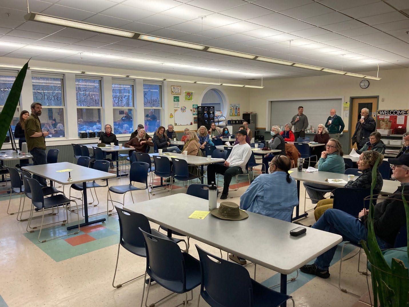
Section 8 Petersham 2024 OSRP pg. 119
Community engagement meeting, Petersham Center School, March 2, 2024
GOAL 1
Petersham will retain its beauty, unique sense of place, and rural character by protecting the health and integrity of its natural assets, including but not limited to its air, drinking water, wetlands, soils, scenic views, working farms, fields, and forests, large blocks of connected forestland, and the diversity of its native flora and fauna.
Objectives:
• Protect the town's surface water, ground water, and wetland resources.
• Protect natural ecosystems from destruction and fragmentation and establish guidelines for growth that minimize development in inappropriate areas.
• Protect and expand the town's large intact forest blocks and wildlife corridors.
• Protect the town's working farmland and forestland, heritage landscapes, and scenic view sheds.
• Protect open space areas which are important for cultural uses.
• Protect historic landscape features from destruction or inappropriate alteration, and encourage climate-conscious, adaptive reuse of historic buildings.
GOAL 2
Petersham will enhance the quality, variety, and accessibility of its open spaces and recreational offerings for the health, well-being, safety, and enjoyment of all residents and visitors.
Objectives:
• Ensure that large portions of the town's open space remain open to the public.
• Provide adequate access to active recreation facilities for field sports and court sports.
• Increase and promote passive and other recreational activities in and on town properties within or near the town center.
• Enhance access and connectivity to hiking and multi-use trails, walking paths, and bike paths, and ensure best roadside management practices for safe pedestrian use of roadways for walking, jogging, running, and bicycling.
• Explore options for swimming and ice skating.
Section 8 Petersham 2024 OSRP pg. 120
GOAL 3 Petersham will increase climate-resilient land practices and active community stewardship of its open spaces, public byways, and private lands.
Objectives:
• Monitor and minimize non-point pollution sources.
• Survey, map, manage, and monitor invasive plant and insect species throughout town.
• Increase the presence of native plants, chosen to suit the conditions and functional needs of their specific location, throughout the town.
• Inventory and protect vernal pools and wetlands throughout town.
• Encourage land use practices that optimize carbon sequestration and biodiversity.
GOAL 4 Petersham will improve communication among Town departments, committees, and residents to increase public awareness about open space access, inclusive cultural and recreational uses, land conservation, and stewardship.
Objectives:
• Keep the town up to date with changing rules around state and federal conservation tools.
• Provide a collection of online resources.
• Provide a collection of resources for in-person viewing and/or distribution.
• Conduct meetings, workshops, and programs about open space, conservation, and recreation.
Section 8 Petersham 2024 OSRP pg. 121
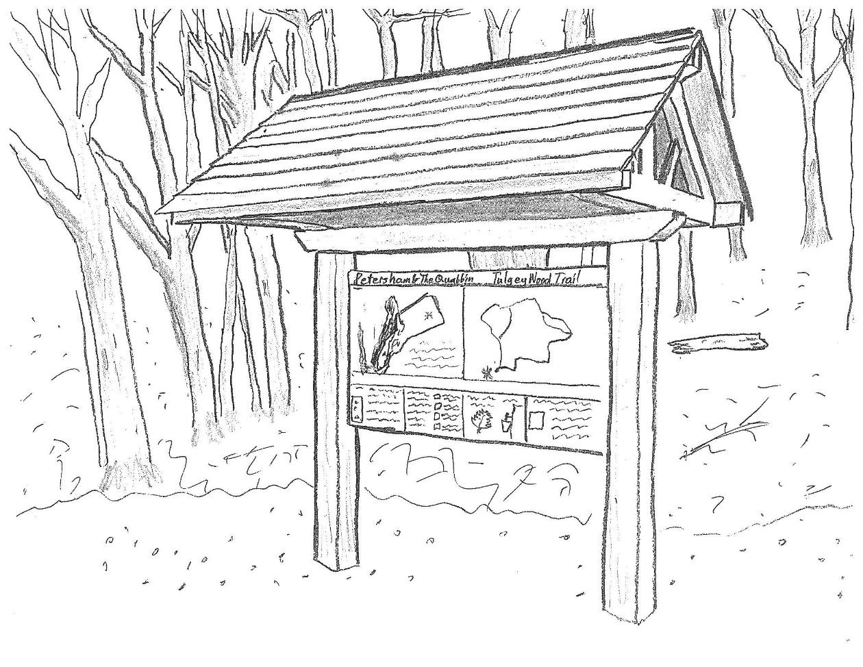
Information kiosks at trailheads could make trails more visible and welcoming, as well as disseminate information.
Section 8 Petersham 2024 OSRP pg. 122
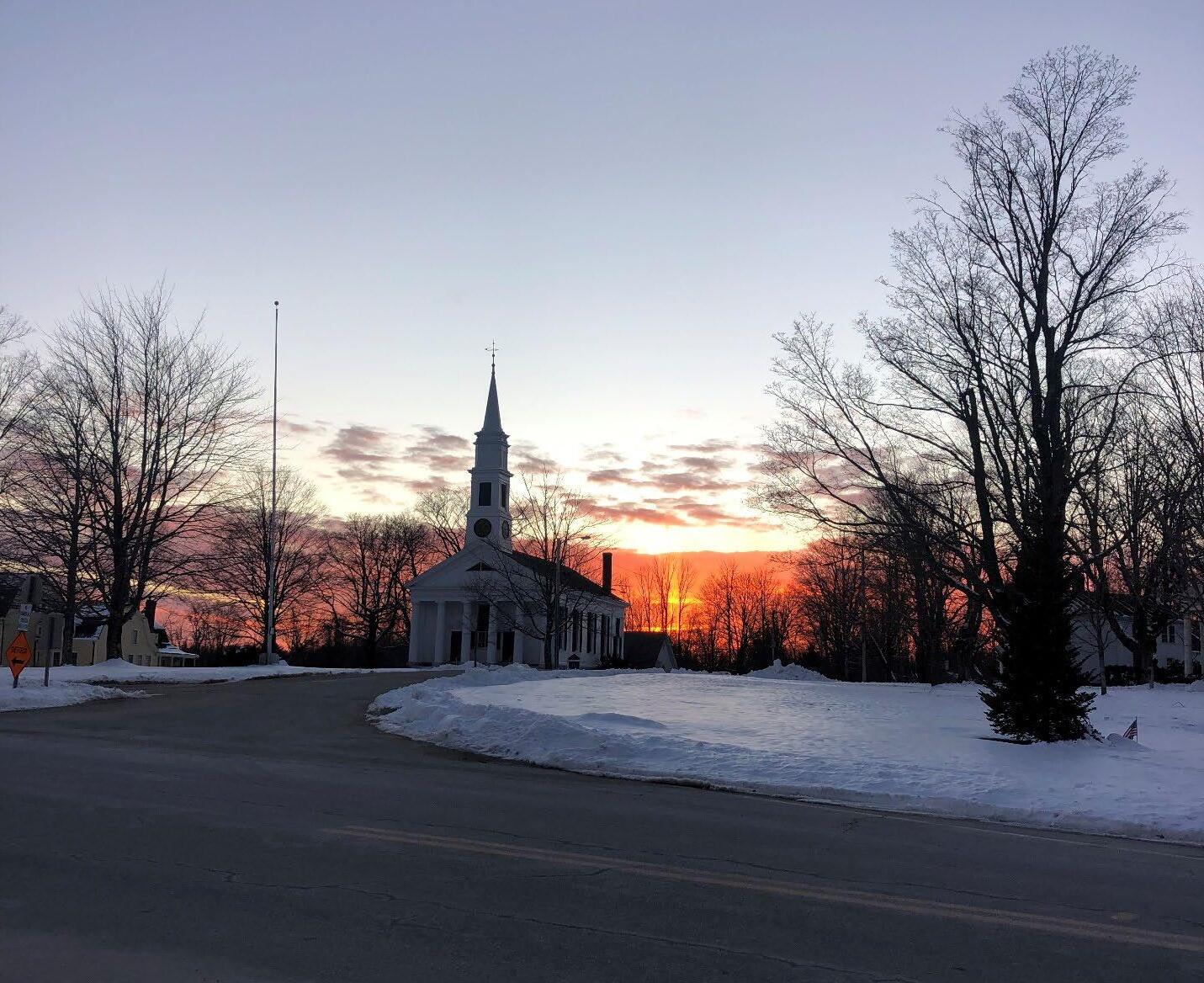
Section 9 Petersham 2024 OSRP pg. 123
Section 9 Seven-Year Action Plan
First Congregational Parish, Unitarian Petersham, Massachusetts
The seven-year action plan offers a list of specific actions to serve Petersham as it makes choices about open space and recreation planning. Each action item is in accordance with the objectives, goals, and vision of the residents of Petersham as written in Section 6: Community Vision
The vision revolves around Petersham’s open space and natural resources providing opportunities for the community and visitors alike to enjoy the rural character and recreational opportunities afforded by them and remaining sustainably affordable while protecting them. These open spaces and natural resources include the air and water, wetlands, soils, scenic views, historic and cultural sites, working farms, fields, forests, and the diversity of its native flora and fauna.
There are four primary goals with associated objectives which are driven by the vision. These inform the specific action items listed below. These goals, objectives, and action items sometimes overlap and at other times conflict. It is important to identify responsible, willing, reciprocal partners for the furtherance of these goals and objectives through the action items. These partners will have to parse out the inherent conflicts such as a desire for development or growth and a desire to protect habitat. This is a living document and needs periodic review and revision as deemed appropriate as the town works through these issues.
Each action item has suggested partners and funding sources as well as a timeline. The action plan map graphically indicates the general scope of the action items. It does not seek to identify specific parcels or actions. The exception is the former site of the Nichewaug Inn because it is a focal point of community interest.
Section 9 Petersham 2024 OSRP pg. 124
Map 9-1: Action Plan
The Action Plan map primarily shows where recreational opportunities exist−facilities at the Center School, Town Hall, and potentially the Nichewaug Inn site and where there are unprotected ecologically significant areas (green) that Petersham may want to put into permanent conservation. It also shows where some new trail connections could be made; these avoid BioMap core habitat (hatched lines) and are based on input from the 2nd community engagement meeting. The BioMap core habitats included on this map are rare species, forests and wetland, and local wetlands.
Section 9 Petersham 2024 OSRP pg. 125
GOAL 1 Petersham will retain its beauty, unique sense of place, and rural character by protecting the health and integrity of its natural assets, including but not limited to its air, drinking water, wetlands, soils, scenic views, working farms, fields, and forests, large blocks of connected forestland, and the diversity of its native flora and fauna.
Objectives:
• Protect the town's surface water, ground water, and wetland resources.
• Protect natural ecosystems from destruction and fragmentation and establish guidelines for growth that minimize development in inappropriate areas.
• Protect and expand the town's large intact forest blocks and wildlife corridors.
• Protect the town's working farmland and forestland, heritage landscapes, and scenic viewsheds.
• Protect open space areas which are important for cultural uses.
• Protect historic landscape features from destruction or inappropriate alteration, and encourage climate-conscious, adaptive reuse of historic buildings.
Action Items
Identify and inventory non-permanently protected open spaces (e.g., forest, wetlands, meadows, fields, croplands, pastures, orchards, hayfields) that coincide with ecologically sensitive areas. Use Maps 4-7 for guidance on identifying unprotected lands.
Ground truth the protection priorities as described in Section 7: Analysis of Needs.
Consider developing prioritization guidelines that can be applied to individual parcels to help the Town with protection and acquisition decisions, particularly when there may be conflicting conservation priorities on a given parcel. Consider modeling these prioritization guidelines on the 2016 Petersham Farmland Inventory guidelines.
Determine the protection tools (e.g., CRs, easements, tax titles, first right of refusal) that are appropriate for each protection priority or parcel of interest.
Perform the Step-By-Step Guide to Conduct Cost of Community Services Ratios for your Massachusetts Town.
Conservation Commission
Conservation Commission, Residents, Volunteers
Section 9 Petersham 2024 OSRP pg. 126
Potential Partners Funding Sources Timeline Priority
Identify financial partners to help in acquisition in case there are parcels deemed to be of high acquisition priority.
As opportunities arise, use Petersham's legal authority to acquire tax title lands for open space.
Educate and advocate for the Town to become a Community Preservation Act (CPA) community, enabling the town to apply for matching grant funds for projects involving open space, historic preservation, affordable housing, and outdoor recreation.
Consider working with other towns in the Quabbin Watershed to advocate for increased state PILOT payments to potentially increase funds available for land conservation.
Monitor joint Bill H897/S447 regarding PILOT payment changes with an eye toward advocacy.
Monitor upcoming legislative and regulatory changes which will make Chapter 61 and 61A more accessible to landowners, per the Massachusetts Clean Energy and Climate Plan for 2025 and 2030.
Continue working with Mount Grace Land Trust to update Petersham’s Farmland Inventory.
Develop a Comprehensive (Master) Plan that clarifies resident housing and development needs and considers the potential impacts of different development approaches on open space. Consider scenario planning to address potential changes in population or development needs.
Work with the Planning Board to adopt an environmentally based site review process that requires consideration of ecological form and function when permitting new development.
Athol, Barre, Belchertown, Hardwick, New Salem, Orange, Pelham, Phillipston, Shutesbury, Ware, Wendell
Mount Grace Land Trust
Planning Board
Continue working with the Conservation Commission to develop a local wetlands bylaw. Conservation Commission
Obtain public trail easements and/or public access to open space as part of new development projects.
Consider working with the Planning Board to update the Scenic Roads By-law.
Planning Board
Planning Board
Section 9 Petersham 2024 OSRP pg. 127
Inventory historic buildings and other locations, especially outside of the town center, that are important to the historic or cultural heritage or scenic viewshed of Petersham.
Consider instituting bylaws governing light pollution.
Work with the Board of Health to address PFAS contamination of well water supply. Provide resources on the Town website to inform residents of the presence of PFAS in well waters and its potential ecological impacts
Encourage private homeowners to test and potentially treat for PFAS in wells. Potential resources to include: the Online Searchable Laboratory Certification Listing, the Mass Be Well Informed (BWI) online lab result interpretation tool, and PFAS sample collection procedures.
Monitor the salinity levels of the wetland adjacent to the Highway Department salt and sand shed.
Develop programming to encourage residents on developed prime agricultural soils in the town center to adopt best landscape management practices to protect this precious resource from erosion, damage, and compaction.
Historical Society
Planning Board
Board of Health, Conservation Commission
Highway Department, Conservation Commission
East Quabbin Land Trust, Mount Grace Land Trust
Section 9 Petersham 2024 OSRP pg. 128
GOAL 2 Petersham will enhance the quality, variety, and accessibility of its open spaces and recreational offerings for the health, well-being, safety, and enjoyment of all residents and visitors.
Objectives:
• Ensure that large portions of the town's open space remain open to the public.
• Provide adequate access to active recreation facilities for field sports and court sports.
• Increase and promote passive and other recreational activities in and on town properties within or near the town center.
• Enhance access and connectivity to hiking and multi-use trails, walking paths, and bike paths, and ensure best roadside management practices for safe pedestrian use of roadways for walking, jogging, running, and bicycling.
• Explore options for swimming and ice skating.
Action Items
Determine appropriate uses for all town-owned parcels for various user groups (e.g., hunting, hiking, snowmobiling, bird watching, dog walking, ice skating)
Establish protocols around using Town Hall for indoor active recreation.
Identify open space areas in Town that can be used seasonally for lawn games, such as the Town Common.
Identify space-appropriate recreation for Townowned indoor venues and seek partners, whether organizations, interest groups, or individuals, who could facilitate those activities.
Identify and collaborate with other organizations, private properties, and indoor public venues in Town, such as the library, to host recreational activities.
Establish protocols around reserving active recreation time at the Center School, including how to reserve indoor courts, accessibility, and fees. Ensure that outdoor courts are available for use outside of school hours.
Review conservation restrictions and record any special conditions. Note easements that particularly address public access and use of those lands.
Petersham Memorial Library
Center School
Section 9 Petersham 2024 OSRP pg. 129
Potential Partners Funding Sources Timeline Priority
Complete a new feasibility study of the Nichewaug Inn site that considers a covered, open-air community gathering space and active recreation needs in addition to housing. Any housing plans should consider incorporating expanded septic for the library.
Identify parcels with possible swimming holes in town. Consider budgeting Conservation Commission funds to acquire suitable parcels that come up for sale in the future. This could be a CPA project.
Reach out to landowners in areas identified for trail connections (map5-4: Trails) to determine their willingness to grant the town access.
Obtain public trail easements and/or public access to open space as part of new development projects.
Have a meeting with groups involved in trail construction and maintenance in town to discuss establishment of a comprehensive cooperative arrangement between the Town, Harvard Forest, The Trustees of Reservations, the Mass Audubon Society, other organizations, trail tenders, and property owners to facilitate coordinated trail construction and maintenance and possibly property maintenance.
Verify and inventory trails in town with georeferencing. Compile and prioritize a comprehensive list of construction and maintenance needs for Town-owned or maintained trails. While Section 7 mentions some trail needs, the list is by no means exhaustive and because trail maintenance is an ongoing need this list will need constant updating.
Inventory public access hunting areas to mitigate conflicts when siting possible trails.
Establish townwide volunteer-based trail cleanup and building days to increase knowledge of and connection to trails throughout Petersham.
Conservation Commission
Harvard Forest, The Trustees of Reservations, the Mass Audubon Society, landowners, and managers
Assess suitability of Town trails for All-Persons Trails requirements. Mass Audubon
Assess the need for parking improvements at the sites identified in Section 7: Analysis of Needs.
Section 9 Petersham 2024 OSRP pg. 130
Davenport Pond Property: Consider improvement to the entrance and parking area and establish new trails if warranted. Continue pursuing action on the Davenport Dam, including consideration of repair versus removal. Assess what other structures may need removal for safety.
Explore extending the network of sidewalks for safe recreational walking around the center of town, Spring Street, and upper portion of Hardwick Road.
Explore the potential of town-wide land-based festivals, events, or fairs to promote ecotourism.
Highway Department
Section 9 Petersham 2024 OSRP pg. 131
GOAL 3 Petersham will increase climate-resilient land practices and active community stewardship of its open spaces, public byways, and private lands.
Objectives:
• Monitor and minimise non-point pollution sources.
• Survey, map, manage, and monitor invasive plant and insect species throughout town.
• Increase the presence of native plants, chosen to suit the conditions and functional needs of their specific location, throughout the town.
• Inventory and protect vernal pools and wetlands throughout town.
• Encourage land use practices that optimize carbon sequestration and biodiversity.
Create a priority schematic for stewardship of open space that protects and promotes clean water, clean air, contiguous forest and other habitat, and wildlife corridors.
Consider participating in DCR's Community Forest Stewardship Program, enabling eligibility for Community Forest Stewardship Grants.
Form a Land Stewardship Committee to build relationships with other stakeholder groups that have a volunteer need or base for land stewardship.
Harvard Forest, Mount Grace, University of the Wild, recreational user groups (mountain biking, hiking, bird watching, dog walkers, etc.), youth groups
Partner with the Center and Mahar Schools to engage students in land stewardship projects and climate resiliency tools.
Consider working with other towns in the Quabbin Watershed to advocate for increased state PILOT payments to potentially increase funds available for land stewardship.
Work with Harvard Forest to create Conservation Corps programs and apply for grants through Harvard Forest to support a Conservation Corps manager to oversee such programs.
Consider hiring Nipmuc community members to steward Town-owned ancestral Nipmuc lands.
PCS, Mahar School
Athol, Barre, Belchertown, Hardwick, New Salem, Orange, Pelham, Phillipston, Shutesbury, Ware, Wendell
Harvard Forest
Harvard Forest, Nipmuc community
Section 9 Petersham 2024 OSRP pg. 132
Action Items Potential Partners Funding Sources Timeline Priority
Continue pursuing a cooperative arrangement between the Town, Harvard Forest, MassDOT Highway, The Trustees, Mass Audubon Society, and private property owners to provide action in the control of invasive species.
Continue to inventory vernal pools in Petersham and pursue certification through the Mass. Natural Heritage and Endangered Species Program so that they might be protected by state regulations.
Hold a public meeting to prioritize invasive species management and identify locations of greatest concern on Town-owned properties. Rally volunteers for work parties to tackle top ranking projects.
Develop planting plans or recommendations to fill vegetative voids created by invasive species removal or die-back of plant clusters because of adverse climate conditions and pests. Prioritize plants that will serve specific functions within the locale being planted.
Verify outlets and assess effects of stormwater and potential street pollutants at the outlet site as well as adjacent wetlands and waterways.
Work with Mass DOT Highway to designate lower salt areas on portions of state highways near sensitive water resources.
Explore septic alternatives suitable for Petersham's soils and ensure proper siting and functioning of septic systems.
Develop trail management strategies to protect trails and surrounding habitat when the ground is saturated.
Engage with the forestry industry in town to come up with ideas for managing wet soils and logging operations.
Compile combined inventories of historic cemeteries, stone walls, mill sites, cellar holes, and foundations. Create a committee or partner with interest groups to maintain or preserve them.
Work with Harvard Forest to educate landowners about land care practices, including forest management practices, that optimize carbon sequestration.
Adopt climate-smart forest management practices as per the Massachusetts Clean Energy and Climate Plan for 2025 and 2030.
Harvard Forest, MassDOT Highway, The Trustees, the Mass Audubon Society, landowners, and managers
Town Highway Department
MASS DOT Highway
Planning Board, Board of Health
Historic Commission, Cemetery Commission
Harvard Forest
Section 9 Petersham 2024 OSRP pg. 133
Continue working with the Conservation Commission to develop a local wetlands bylaw in recognition of wetlands' outstanding carbon sequestration capabilities.
Adopt the Municipal Vulnerability Preparedness Plan begun in 2024 and ensure that its objectives are consistent with this OSRP's climate resiliency priorities.
Work with the Conservation Commission and Highway Department in cooperation with the Emergency Management Committee and Police Department, Harvard Forest, The Trustees of Reservations, and Mass Audubon to develop plans and procedures in the event of extreme storm events.
Conduct yearly assessments and potential reprioritizations of the 2024 OSRP Action Items.
In 2029 start preparing for updating the next OSRP and complete before the previous one expires.
Conservation Commission
Town, Harvard Forest, Trustees, Mass Audubon
OSRP Committee
Section 9 Petersham 2024 OSRP pg. 134
GOAL 4 Petersham will improve communication among Town departments, committees, and residents to increase public awareness about open space access, inclusive cultural and recreational uses, land conservation, and stewardship.
Objectives:
• Keep the town up to date with changing rules around state and federal conservation tools.
• Provide a collection of online resources.
• Provide a collection of resources for in-person viewing and/or distribution.
• Conduct meetings, workshops, and programs about open space, conservation, and recreation.
Action Items
Follow up with prospective volunteers from Fall 2023 OSRP Survey to form interest groups.
Explore opportunities to acknowledge the impact of colonial settlement on Indigenous communities in Petersham and the region. Consider forming a Truth Committee.
Partner with organizations that already have established relationships with Nipmuc groups to enter conversations about land rematriation, preservation priorities, and cultural use agreements after establishing a Truth Commission.
Inform residents and Town personnel of the existing cultural use rights of Indigenous groups in the region.
Post information online and in publicly accessible areas regarding the continued presence and culturaluse-rights of Indigenous Peoples.
Identify where hunting is allowed or encouraged in Petersham. Make that information available to the public, along with contextual information about cultural use and forest regeneration
Improve the Town website and online events calendar to reflect recreational activities in town. Include guides to when and where recreational activities are allowed.
Consider hosting a Mahar student project to build an interactive town map with recreation data layers. For example, the pickleball layer, when clicked, would show all pickleball court locations in town. Recreational interests could include fishing, hunting, hiking, bird watching, etc.
Post resources for Chapter 61 programs, Conservation Restriction easements, Agricultural Preservation Restrictions, and forest management and stewardship plans on the Town's website.
Mount Grace, Harvard Forest, Nipmuc communities
Mount Grace, Harvard Forest, Nipmuc communities
Mount Grace, Harvard Forest, Nipmuc communities
Mount Grace, Harvard Forest, Nipmuc communities
Mahar Regional School
Mount Grace, Harvard Forests,
Section 9 Petersham 2024 OSRP pg. 135
Potential Partners Funding Sources Timeline Priority
Combine existing trail maps currently available through Harvard Forest, The Trustees, Mass Audubon, DCR, Mount Grace, East Quabbin Land Trust, and others into one comprehensive map for physical and digital distribution. Look into inclusion of recreational opportunities listed on the All-Trails app.
Prepare a town-wide recreation, trailhead, and attractions map for physical and digital distribution. this may or may not be combined with the trail map. Include responsible trail use information, such as carry-in/carry-out and use-guidelines for wet trails.
Include contact information on the maps and at trailheads so that trail users can report trail maintenance needs such as washouts and trees across the path.
Provide interpretive and educational materials (such as the Slab City Tract Field Trip booklet) for important natural and historic areas as online resources as well as printed materials.
Consider building kiosks at trailheads and in Town Center. The kiosks can feature large scale versions of the town-wide attractions map and trails map. These kiosks could also be used to distribute sitespecific or town and regional maps or pamphlets.
Partner with other organizations to provide in-person and/or online workshops to help land tenders to become effective stewards of the land.
Consider hosting workshops and informational meetings to inform residents about the State's carbon sequestration efforts and how they affect forestry guidelines, state forestry contracts, and programs like Chapter 61. Consider hosting these events around Chapter 61 renewal dates.
Partner with other organizations, such as East Quabbin Land Trust, to host town-wide seminars on the effects of climate change on local and regional ecosystems.
Consider hosting a town-wide meeting addressing the fragmentation of land and critical habitat by private holdings; advocate for abutting landowners to collaborate on forest management practices and provide appropriate resources, such as forestry management information and equipment sharing opportunities
Harvard Forest, The Trustees, Mass Audubon, DCR, Mount Grace, East Quabbin Land Trust, Montachusett Regional Planning Commission
Harvard Forest, UMass Extension
East Quabbin Land Trust, Mount Grace, Harvard Forest, NRCS, UMass Extension
NRCS
Section 9 Petersham 2024 OSRP pg. 136
Section 10
Public Comment
Comments from Community Engagement Meeting, 2/3/2024
Section 10 Petersham 2024 OSRP pg. 137
Section 10 Petersham 2024 OSRP pg. 138
Section 11
References
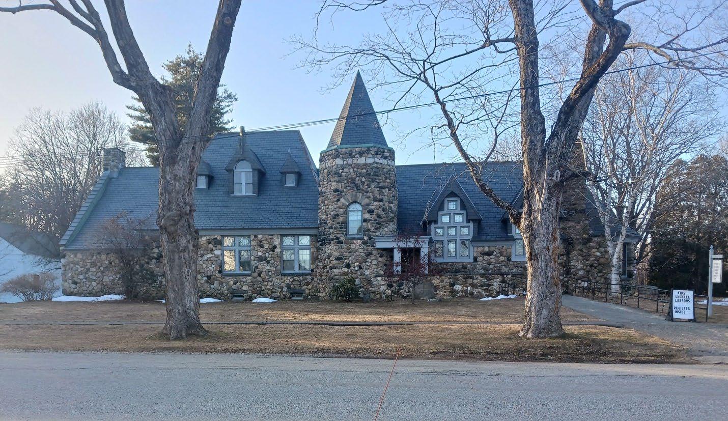
Section 11 Petersham 2024 OSRP pg. 139
Petersham Memorial Library, Petersham, Massachusetts
“Analysis of Water Contamination in Massachusetts.” Massachusetts Sierra Club, 27 Oct. 2021.
Anderson MG, Ferree CE (2010) Conserving the Stage: Climate Change and the Geophysical Underpinnings of Species Diversity. PLoS ONE 5(7): e11554.doi:10.1371/journal.pone.0011554
Andrews, David Q., et al. “Discussion. Has the Human Population Become a Sentinel for the Adverse Effects of PFAS Contamination on Wildlife Health and Endangered Species?” Science of the Total Environment, vol. 901, 26 Sept. 2023, p. 165939, www.sciencedirect.com/science/article/pii/S0048969723045643, https://doi.org/10.1016/j.scitotenv.2023.165939. Accessed 27 Mar. 2024.
Beau, Brodbeck, and William Rowe. “Saturated Soils and Wind: A Recipe for Toppling Trees.” Alabama Cooperative Extension System, 25 Feb. 2019, www.aces.edu/blog/topics/forestry/saturated-soils-and-wind-a-recipe-for-toppling-trees/.
Black, John D. and Brinser, Ayers. Planning One Town: Petersham A Hill Town in Massachusetts. Harvard University Press, 1952.
Bryant, Lara. “Organic Matter Can Improve Your Soil’s Water Holding Capacity.” NRDC, May 27, 2015. https://www.nrdc.org/bio/lara-bryant/organic-matter-can-improve-your-soilswater-holding-capacity.
“Bounty Teachers Guide | the Sixth Anglo Abenaki War.” Www.bountyfilm.org, www.bountyfilm.org/lesson-three/the-sixth-anglo-abenaki-war#Scalping-In-TheDawnland. Accessed 20 Mar. 2024.
Cates, Anna. “The Connection between Soil Organic Matter and Soil Water.” Minnesota Crop News, March 24, 2020. https:// blog-crop-news.extension.umn.edu/2020/03/theconnection-be- tween-soil-organic.html.
“Census Data API: /Data/2020/Dec/Dp.” Api.census.gov, api.census.gov/data/2020/dec/dp.html. Accessed 20 Mar. 2024.
“Census Profile: Petersham Town, Worcester County, MA.” Census Reporter, censusreporter.org/profiles/06000US2502753120-petersham-town-worcester-county-ma/. Accessed 20 Mar. 2024.
“Census Profile: Petersham, MA.” Census Reporter, censusreporter.org/profiles/16000US2553085-petersham-ma/. Accessed 20 Mar. 2024.
Commonwealth of Massachusetts Land Court Department of the Trial Court. Sunpin Energy Services, LLC and Ralph P. Lapinkas, Jr., Plaintiffs, v. Donald J. O’Neil et al., in their capacity as Members of the Zoning Board of Appeal of Petersham, 2023
Section 11 Petersham 2024 OSRP pg. 140
The Conference with the Eastern Indians, at the Ratification of the Peace, Held at Falmouth in Casco-Bay, in July and August, 1726. 1 Oct. 2009, quod.lib.umich.edu/e/evans/N05687.0001.001/1:5.1?rgn=div2. Accessed 4 Apr. 2024.
Coolidge, Mabel Cook. The History of Petersham, Massachusetts. Higginson Book Company, 1948.
“Country Store Fact Sheet.” East Quabbin Land Trust. https://eqlt.org/wpcontent/uploads/2013/06/Country-Store-Fact-Sheet.pdf
“Dam Safety Inspection Requirements | Mass.gov.” Www.mass.gov, www.mass.gov/infodetails/dam-safety-inspection-requirements. Accessed 21 Mar. 2024
“Dam Safety Performance Report: Maine.” Association of State Dam Safety Officials.
“Davenport Pond Dam.” National Inventory of Dams. https://nid.sec.usace.army.mil/#/dams/system/MA01764/inspections
“DCR Watershed Plans.” Mass.gov, https://www.mass.gov/info-details/dcr-watershed-plans
“Deer Management | Mass.gov.” Www.mass.gov, www.mass.gov/info-details/deer-management.
Ehrenpreis, Jamie E., and Eli D. Ehrenpreis. “An Historical Perspective of Healthcare Disparity and Infectious Disease in the Native American Population.” The American Journal of the Medical Sciences, vol. 363, no. 4, 24 Jan. 2022, www.ncbi.nlm.nih.gov/pmc/articles/PMC8785365/, https://doi.org/10.1016/j.amjms.2022.01.005
“Evans Early American Imprint Collection.” Quod.lib.umich.edu, quod.lib.umich.edu/cgi/t/text/text-idx?c=evans.
“Fiscal Impacts of Land Use in Massachusetts: Up-to date Cost of Community Services Analyses for 4 Massachusetts Communities.” Murray, Helena and Catanzaro, Paul. Umass Amherst, 2019.
“HHS Poverty Guidelines 1983-2024”, U.S. Department of Health and Human Services, Office of the Assistant Secretary for Planning and Evaluation.
“History | Harvard Forest.” Harvardforest.fas.harvard.edu, harvardforest.fas.harvard.edu/history#:~:text=At%20its%20founding%20in%201907. Accessed 21 Mar. 2024.
History – Hassanamisco Indian Museum. www.nipmucmuseum.org/history/.
Section 11 Petersham 2024 OSRP pg. 141
Holley, Cheryll Toney. “A Brief Look at Nipmuc History.” Strangers in Our Land, 27 Sept. 2009, nativenewengland.wordpress.com/2009/09/26/a-brief-look-at-nipmuc-history-bycheryll-toney-holley/. Accessed 20 Mar. 2024.
Hydrargyrum, Nikater; adapted to English by. “English: Tribal Territories of Southern New England Tribes about 1600. Grey Dotted Lines Are Approximate Modern Political Boundaries.” Wikimedia Commons, 25 Nov. 2008, commons.wikimedia.org/wiki/File:Tribal_Territories_Southern_New_England.png. Accessed 20 Mar. 2024.
iNaturalist. “Observations.” INaturalist, www.inaturalist.org/observations?nelat=42.5502309&nelng=72.1008839&place_id=any&swlat=42.3427519&swlng=-72.315994&view=species. Accessed 1 Apr. 2024.
Kim, JiHyun, et al. “Increased Water Yield due to the Hemlock Woolly Adelgid Infestation in New England.” Geophysical Research Letters, vol. 44, no. 5, 15 Mar. 2017, pp. 2327–2335, https://doi.org/10.1002/2016gl072327.
Knowing Nipmuc – Hassanamisco Nipmuc Band. www.nipmucband.org/knowing-nipmuc/. Accessed 20 Mar. 2024.
“Knowing Nipmuc -Nipmuc History Pt 1_1.Mp4.” Google Docs, drive.google.com/file/d/1q_ym2YosTCdJ10lp4t14mme8g_wZhi3F/view. Accessed 20 Mar. 2024.
Kopansky, Dianna. “Peatlands Store Twice as Much Carbon as All the World’s Forests.” UN Environment, 1 Feb. 2019, www.unep.org/news-and-stories/story/peatlands-store-twicemuch-carbon-all-worlds-forests.
“Labor Market Information.” Mass.gov, lmi.dua.eol.mass.gov/lmi/LaborForceAndUnemployment/TownComparison.
Lord, William G., and Allen County Public Library Genealogy Center. History of Athol, Massachusetts. Internet Archive, Athol, Mass, 1953, archive.org/details/historyofatholma00lord/page/n5/mode/2up. Accessed 20 Mar. 2024.
Managing Forests for Climate Change in Massachusetts ..., www.mass.gov/doc/managingforests-for-climate-change-in-massachusetts-forester-guide/download. Accessed 20 Mar. 2024.
Masschusetts Department of Conservation and Recreation. “Watershed Protection Act Viewer.” Experience.arcgis.com, 18 Mar. 2024, experience.arcgis.com/experience/6b2d62c1611f48f38c890dc717ff4459/.
Section 11 Petersham 2024 OSRP pg. 142
Massachusetts Department of Environmental Protection. Source Water Assessment and Protection (SWAP) Report Quabbin Reservoir, Ware River and Wachusett Reservoir. Massachusetts Water Resources Authority (MWRA), June 2002.
Massachusetts Division of Fisheries and Wildlife Natural Heritage & Endangered Species Program. Eastern Whip-Poor-Will Antrostomus Vociferus . 2019.
Massachusetts Division of Fisheries and Wildlife Natural Heritage Endangered Species Program. “Rare Species Viewer | Mass.gov.” Www.mass.gov, www.mass.gov/info-details/rarespecies-viewer.
Massachusetts Division of Fisheries and Wildlife Natural Heritage & Endangered Species Program. “Sweet Coltsfoot Petasites Frigidus Var. Palmatus.” 2015.
“Massachusetts Rivers Protection Act Protecting the Commonwealth’s Rivers, Streams, and Adjacent Lands.” www.mass.gov, www.mass.gov/doc/about-the-massachusetts-rivers protection-act/download
Massachusetts Water Resources Authority. History: Quabbin and Ware. www.mwra.com/04water/html/hist5.htm. Accessed 18 Mar. 2024.
“MassGIS Data: 2016 Land Cover/Land Use | Mass.gov.” Www.mass.gov, www.mass.gov/infodetails/massgis-data-2016-land-coverland-use.
“MassGIS Data: 2020 U.S. Census TIGER Roads | Mass.gov.” Www.mass.gov, www.mass.gov/info-details/massgis-data-2020-us-census-tiger-roads?_gl=1. Accessed 22 Mar. 2024.
“MassGIS Data: 2020 U.S. Census Towns | Mass.gov.” Www.mass.gov, www.mass.gov/infodetails/massgis-data-2020-us-census-towns.
“MassGIS Data: Counties | Mass.gov.” Www.mass.gov, www.mass.gov/info-details/massgisdata-counties?_gl=1. Accessed 22 Mar. 2024.
“MassGIS Data: Dams | Mass.gov.” Www.mass.gov, www.mass.gov/info-details/massgis-datadams?_gl=1. Accessed 20 Mar. 2024.
“MassGIS Data: MassDEP Hydrography (1:25,000) | Mass.gov.” Www.mass.gov, www.mass.gov/info-details/massgis-data-massdep-hydrography-125000?_gl=1. Accessed 22 Mar. 2024.
“MassGIS Data: MassGIS-MassDOT Roads | Mass.gov.” Www.mass.gov, www.mass.gov/infodetails/massgis-data-massgis-massdot-roads?_gl=1. Accessed 22 Mar. 2024.
Section 11 Petersham 2024 OSRP pg. 143
“MassGIS Data: MWRA Water/Sewer Service Areas | Mass.gov.” Www.mass.gov, www.mass.gov/info-details/massgis-data-mwra-watersewer-service-areas?_gl=1. Accessed 22 Mar. 2024.
“MassGIS Data: NRCS HUC Basins (8,10,12) | Mass.gov.” Www.mass.gov, www.mass.gov/info-details/massgis-data-nrcs-huc-basins-81012?_gl=1. Accessed 22 Mar. 2024.
“MassGIS Data: Property Tax Parcels | Mass.gov.” Www.mass.gov, www.mass.gov/infodetails/massgis-data-property-tax-parcels.
“MassGIS Data: Protected and Recreational OpenSpace | Mass.gov.” Www.mass.gov, www.mass.gov/info-details/massgis-data-protected-and-recreational-openspace?_gl=1. Accessed 26 Mar. 2024.
“National Inventory of Dams.” Nid.sec.usace.army.mil, nid.sec.usace.army.mil/#/dams/system/MA01764/inspections. Accessed 20 Mar. 2024.
“Nichewaug Inn Market and Feasibility Analysis.” Concord Square Planning and Development, Inc., 2016
“No. 126: Massachusetts Native Americans | Mass.gov.” Www.mass.gov, www.mass.gov/executive-orders/no-126-massachusetts-nativeamericans#:~:text=In%20support%20of%20the%20concept. Accessed 4 Apr. 2024.
“Open Space and Recreation Planner’s Workbook.” Massachusetts Division of Conservation Services, 2008.
Orwig, David, et al. “Harvard Forest Data Archive | Harvard Forest.” Harvard.edu, 2019, harvardforest1.fas.harvard.edu/exist/apps/datasets/showData.html?id=hf083. Accessed 3 Apr. 2024.
“Petersham Farmland Inventory.” Mount Grace Land Preservation Trust, 2016.
“Petersham Final Master Plan; Final Open Space & Recreation Plan”, Petersham Ad-Hoc Planning Committee, Daylor Consulting Group, 2004.
Petersham Historical Society. Petersham, Massachusetts A Concise Timeline. Petersham Historical Society, 2007-2015.
“Petersham Reconnaissance Report.” Massachusetts Department of Conservation and Recreation, 2008.
“Petersham Topographic Map, Elevation, Terrain.” Topographic Maps, en-us.topographicmap.com/map-k4s57/Petersham/. Accessed 20 Mar. 2024.
Section 11 Petersham 2024 OSRP pg. 144
Regenerative Design Group, et al. The Massachusetts Healthy Soils Action Plan . 2022.
“Report: New England Forests Can Do More to Combat Climate Change.” Report: New England Forests Can Do More to Combat Climate Change | Harvard Forest, harvardforest.fas.harvard.edu/news/report-informs-policy-making-process-detailing-howforests-contribute-climate-change-mitigation. Accessed 20 Mar. 2024.
“Sale of Land or CR.” East Quabbin Land Trust. https://eqlt.org/land-protection/sale/
Searcy, Karen B., et al. “Influence of Bedrock and Aspect on Soils and Plant Distribution in the Holyoke Range, Massachusetts.” Journal of the Torrey Botanical Society, vol. 130, no. 3, July 2003, p. 158, https://doi.org/10.2307/3557551. Accessed 21 May 2021
“Seven Acre Preserve.” East Quabbin Land Trust https://eqlt.org/seven-acre-preserve/
Shepard, Donald & Kuhns, Andrew & Dreslik, Michael & Phillips, Christopher. (2008). Roads as barriers to animal movement in fragmented landscapes. Animal Conservation. 11. 288 - 296. 10.1111/j.1469-1795.2008.00183.x.
“This Map Shows Where Americans Will Migrate Once Sea Levels Rise.” Global Center on Adaptation, 12 Feb. 2020, gca.org/this-map-shows-where-americans-will-migrate-oncesea-levels-rise/.
“Town of Petersham Affordable Housing Plan.” Petersham Affordable Housing Task Force, 2005.
Town of Petersham Annual Report, FY 2022 (July 1, 2021 – Jun 30, 2022)
“Town of Petersham Open Space & Recreation Plan, 2014.” Robert A. Clark, 2014.
U.S. Census Bureau. "PROFILE OF GENERAL POPULATION AND HOUSING CHARACTERISTICS." Decennial Census, DEC Demographic Profile, Table DP1, 2020 UNESCO. “World Heritage.” Unesco.org, 2023, www.unesco.org/en/world-heritage.
United Nations. “Biodiversity - Our Strongest Natural Defense against Climate Change.” United Nations, United Nations, 2022, www.un.org/en/climatechange/science/climateissues/biodiversity.
US Census Bureau. “The Number of People Primarily Working from Home Tripled between 2019 and 2021.” Census.gov, 15 Sept. 2022, www.census.gov/newsroom/pressreleases/2022/people-working-from-home.html.
“Wampanoag Fishing Rights - Appeals Court.” Umass.edu, 2024, people.umass.edu/derrico/wampanoag/appeals.html. Accessed 4 Apr. 2024.
Section 11 Petersham 2024 OSRP pg. 145
“Zoning By-Laws of the Town of Petersham, Massachusetts.” Town of Petersham, 2018.
Maps Used to create Map 3-4: Lands Attributed to the Nipmuc:
“About | Native American Trail’s Project.” Www.umass.edu, www.umass.edu/nativetrails/. Accessed 20 Mar. 2024.
“Historical Atlas of Massachusetts.” Www.geo.umass.edu, www.geo.umass.edu/faculty/wilkie/Wilkie/maps.html.
“Knowing Nipmuc -Nipmuc History Pt 1_1.Mp4.” Google Docs, drive.google.com/file/d/1q_ym2YosTCdJ10lp4t14mme8g_wZhi3F/view. Accessed 20 Mar. 2024.
Native Land Digital. “NativeLand.ca.” Native Land Digital, 2024, native-land.ca/.
“Nipmuc Nation.” Www.umass.edu, www.umass.edu/nativetrails/nations/Nipmuc/nipmuc.html. Accessed 20 Mar. 2024
Tougias, Michael. “King Philip’s War.” Bill of Rights Institute, billofrightsinstitute.org/essays/king-philips-war.
USDA Natural Resources Conservation Service. Prime and Other Important Farmlands of Worcester Massachusetts. 13 Sept. 2019.
Section 11 Petersham 2024 OSRP pg. 146
Appendix A 2023 OSRP Community Survey Results
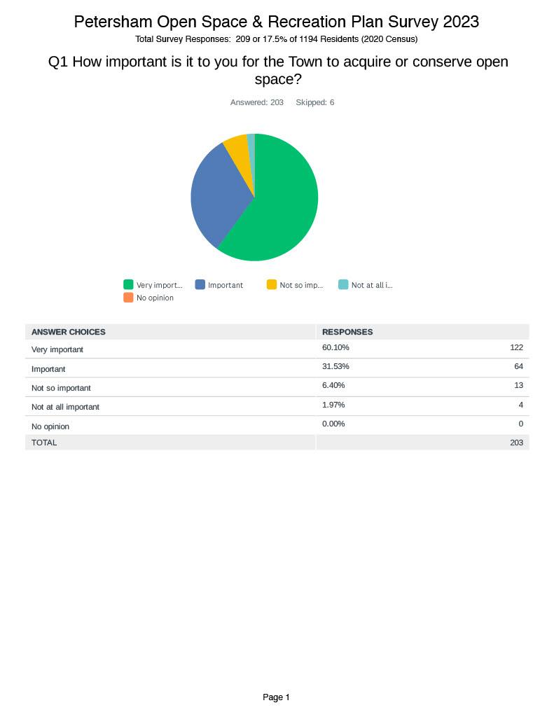
Appendix A Petersham 2024 OSRP pg. 1
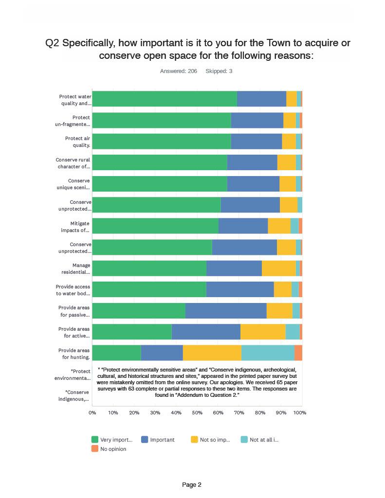
Appendix
Petersham 2024 OSRP pg. 2
A
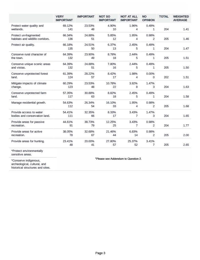
Appendix
Petersham 2024 OSRP pg. 3
A
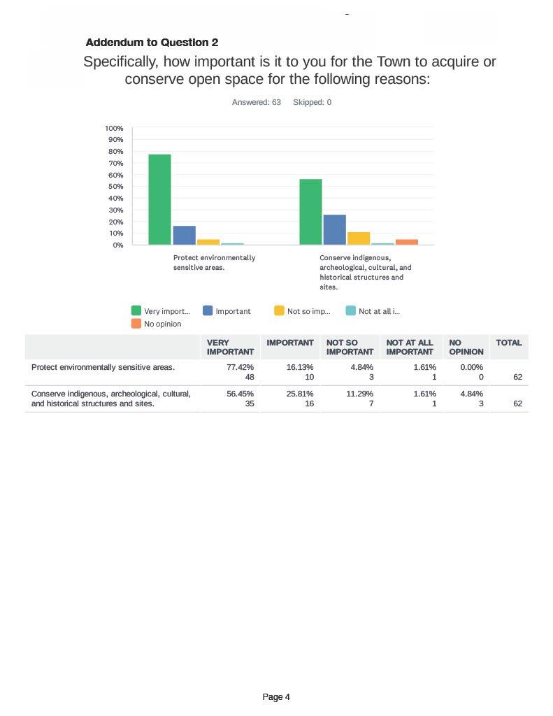
Appendix
Petersham 2024 OSRP pg. 4
A
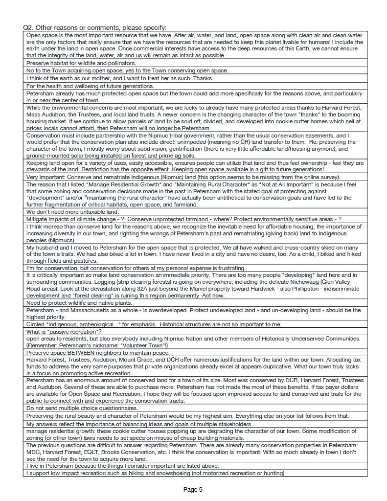
Petersham
OSRP pg. 5
Appendix A
2024
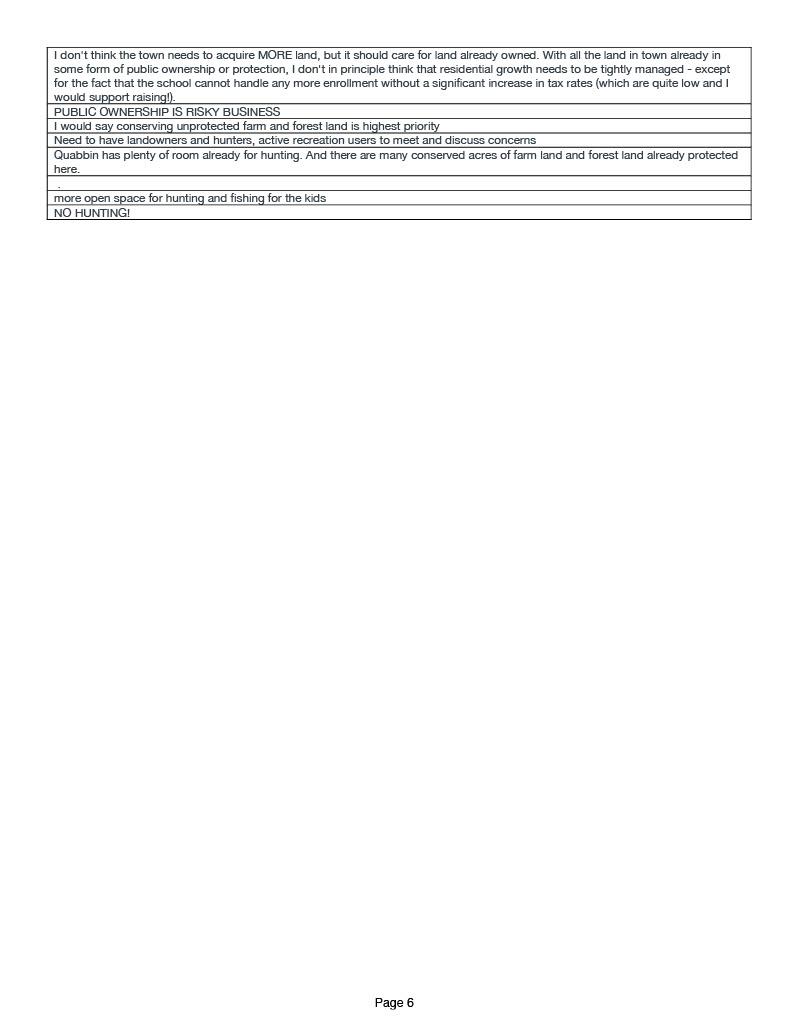
Petersham
OSRP pg. 6
Appendix A
2024
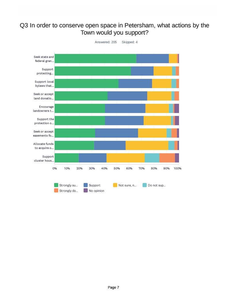
Appendix A Petersham 2024 OSRP pg. 7
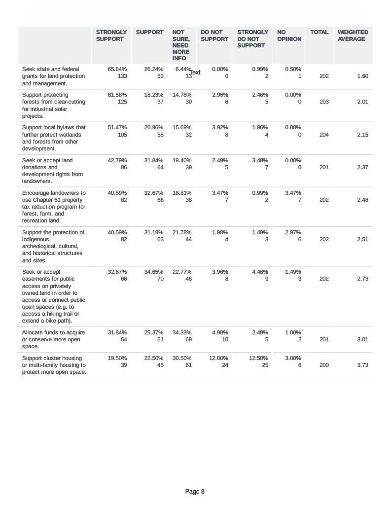
Appendix
Petersham 2024 OSRP pg. 8
A
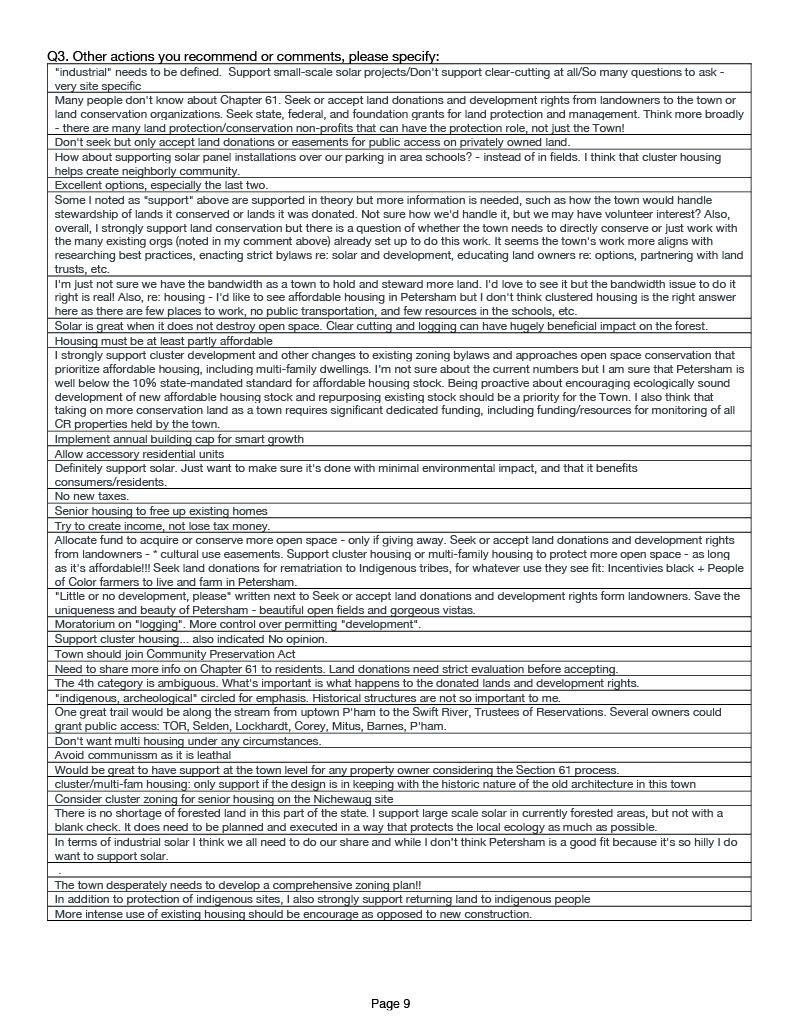
Appendix
Petersham 2024 OSRP pg. 9
A
Appendix
Petersham 2024 OSRP pg. 10
A
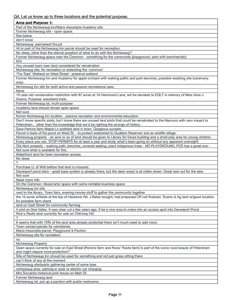
Appendix
Petersham 2024 OSRP pg. 11
A
Appendix
Petersham 2024 OSRP pg. 12
A
Appendix
Petersham 2024 OSRP pg. 13
A
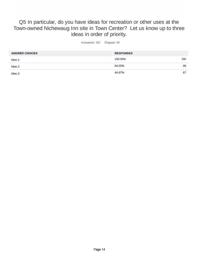
Appendix
Petersham 2024 OSRP pg. 14
A
Appendix
Petersham 2024 OSRP pg. 15
A
Appendix
Petersham 2024 OSRP pg. 16
A
Appendix
Petersham 2024 OSRP pg. 17
A
Appendix
Petersham 2024 OSRP pg. 18
A
Appendix
Petersham 2024 OSRP pg. 19
A
Appendix
Petersham
OSRP pg. 20
A
2024
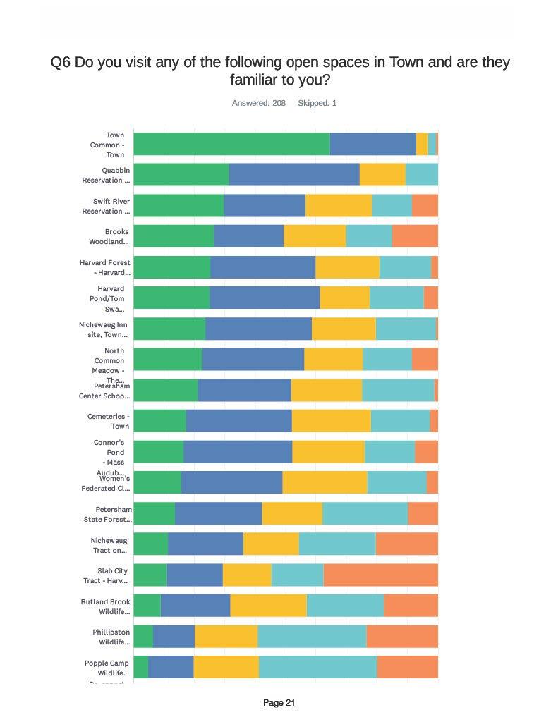
Appendix A Petersham 2024 OSRP pg. 21
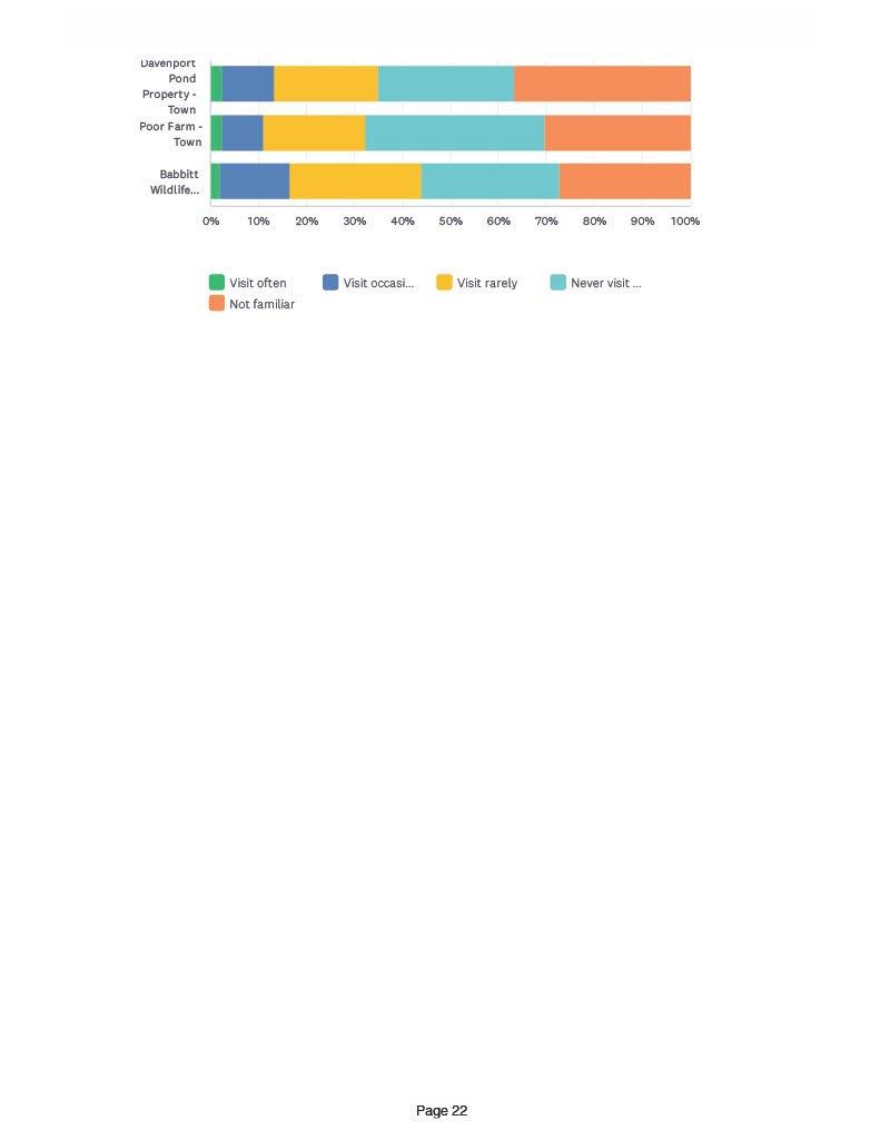
Petersham
OSRP pg. 22
Appendix A
2024
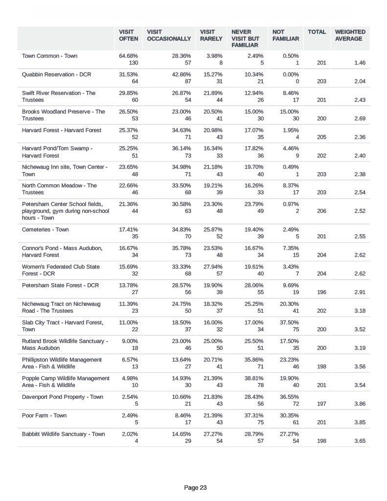
Appendix
Petersham 2024 OSRP pg. 23
A
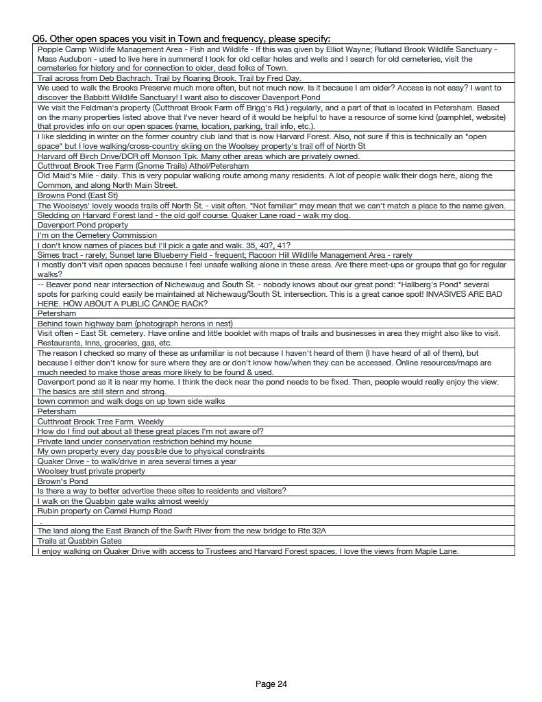
Appendix
Petersham
OSRP pg. 24
A
2024

Appendix
Petersham 2024 OSRP pg. 25
A
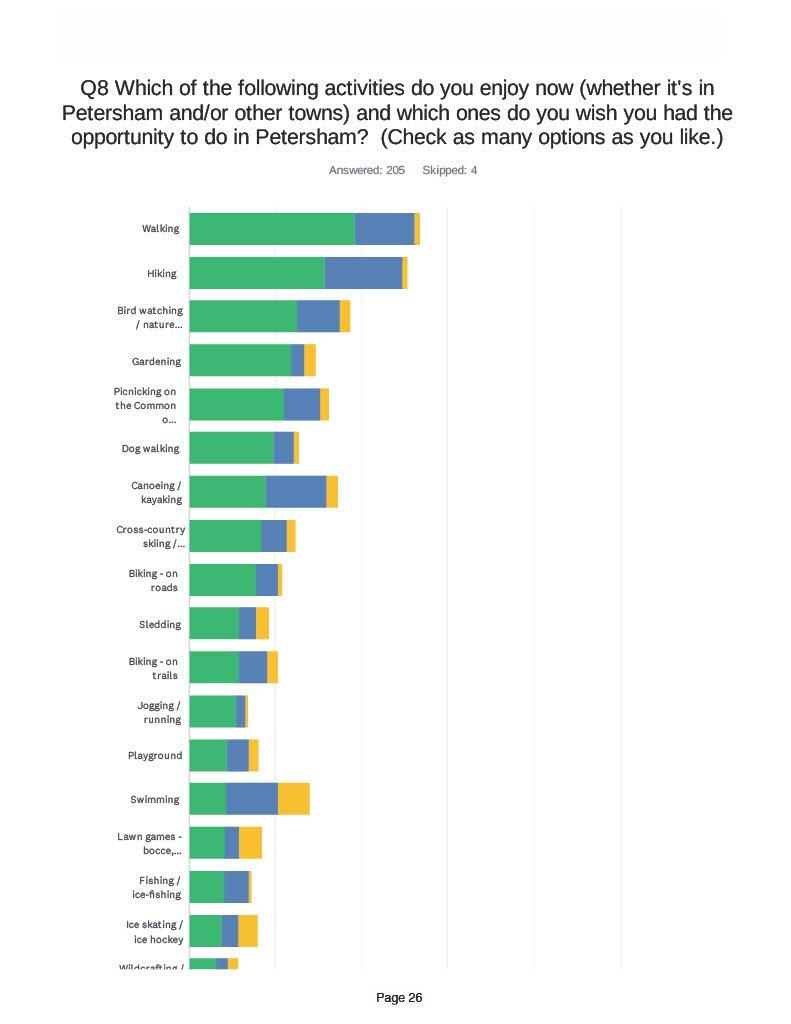
Appendix
Petersham 2024 OSRP pg. 26
A
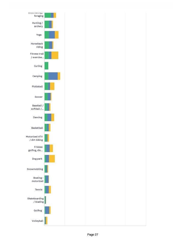
Appendix
Petersham 2024 OSRP pg. 27
A

Appendix
Petersham 2024 OSRP pg. 28
A
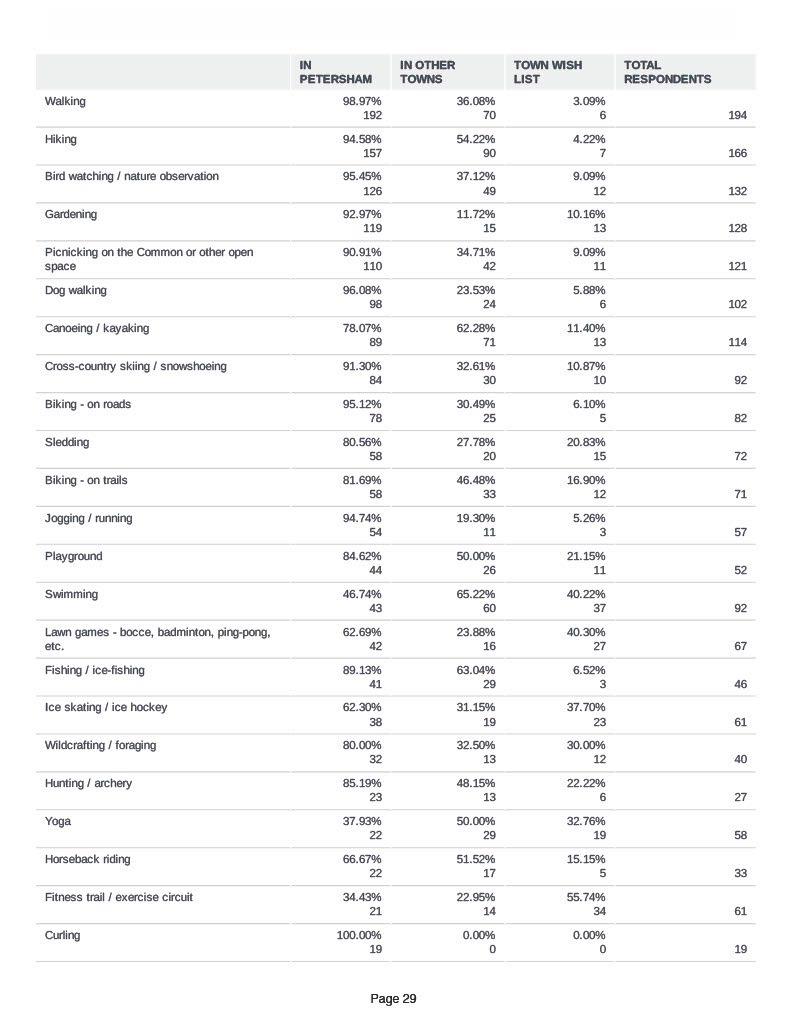
Appendix
Petersham 2024 OSRP pg. 29
A
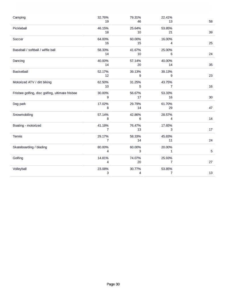
Appendix
Petersham 2024 OSRP pg. 30
A

Appendix
Petersham 2024 OSRP pg. 31
A
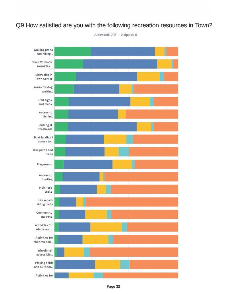
Appendix A Petersham 2024 OSRP pg. 32
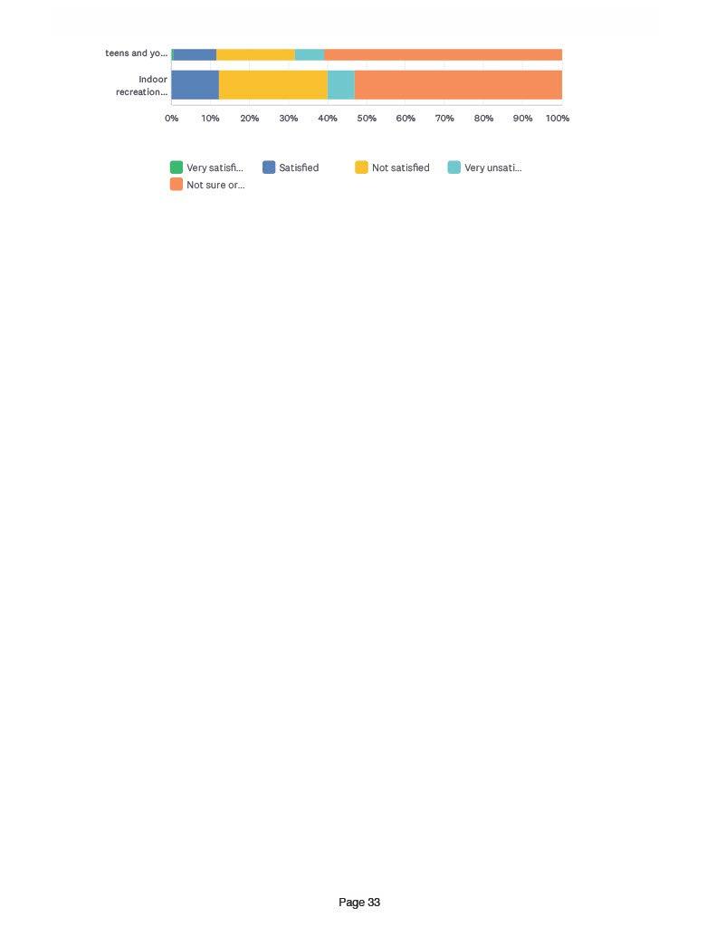
Appendix A Petersham 2024 OSRP pg. 33

Appendix A Petersham 2024 OSRP pg. 34
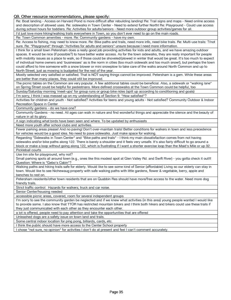
Appendix
Petersham 2024 OSRP pg. 35
A
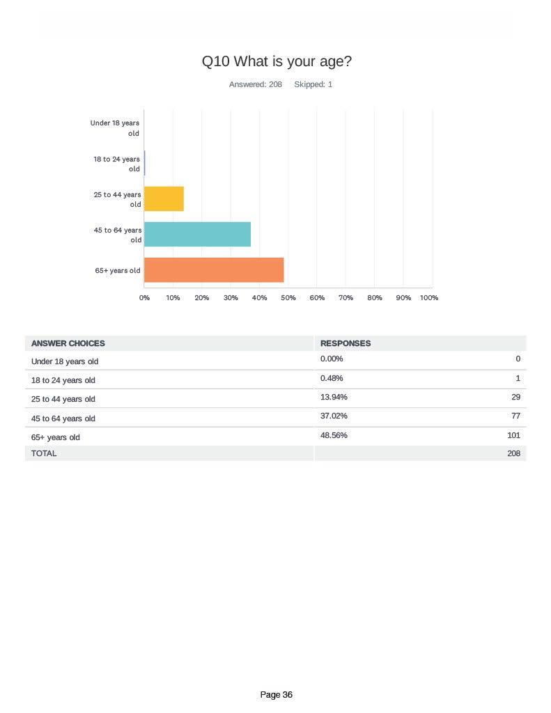
Appendix A Petersham 2024 OSRP pg. 36
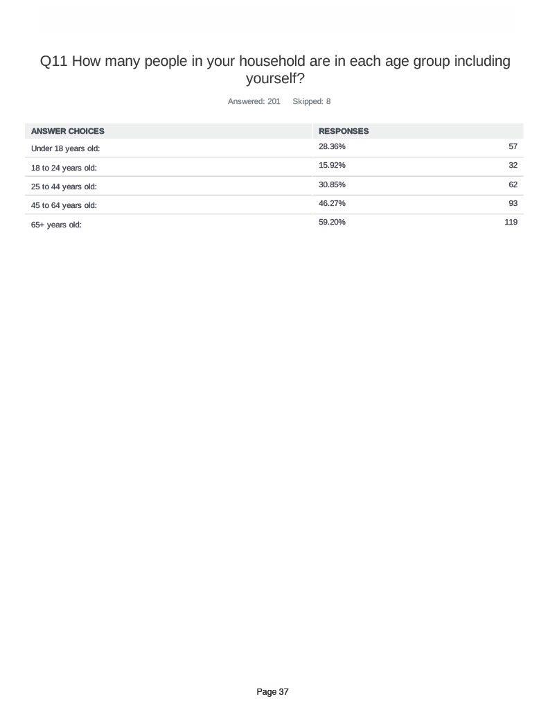
Appendix A Petersham 2024 OSRP pg. 37
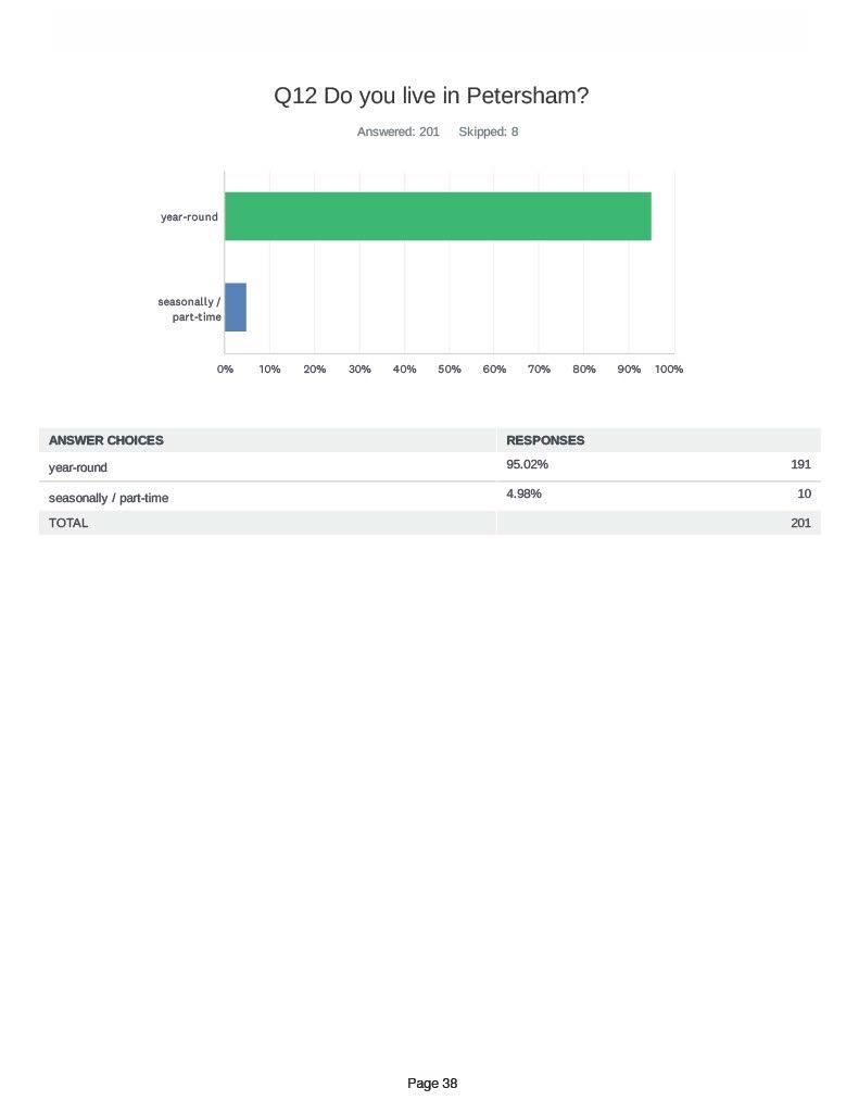
Appendix A Petersham 2024 OSRP pg. 38
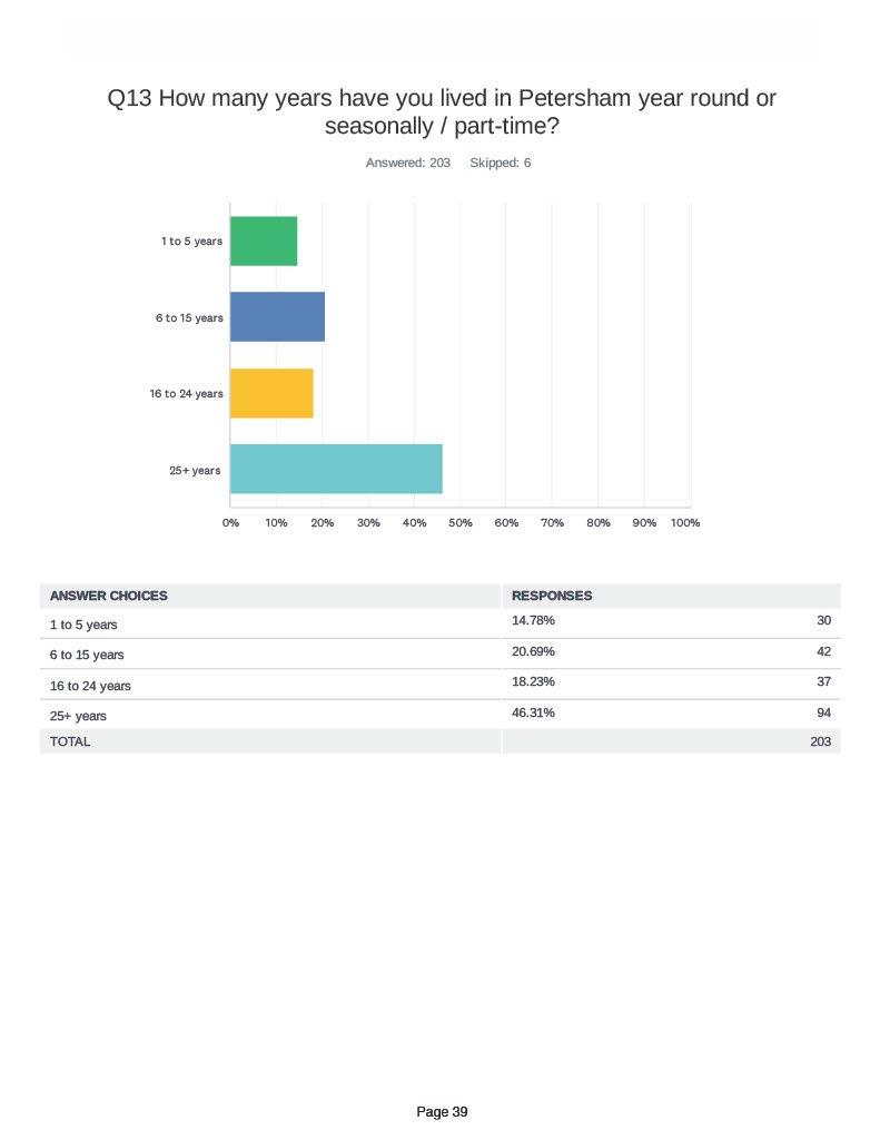
Appendix A Petersham 2024 OSRP pg. 39
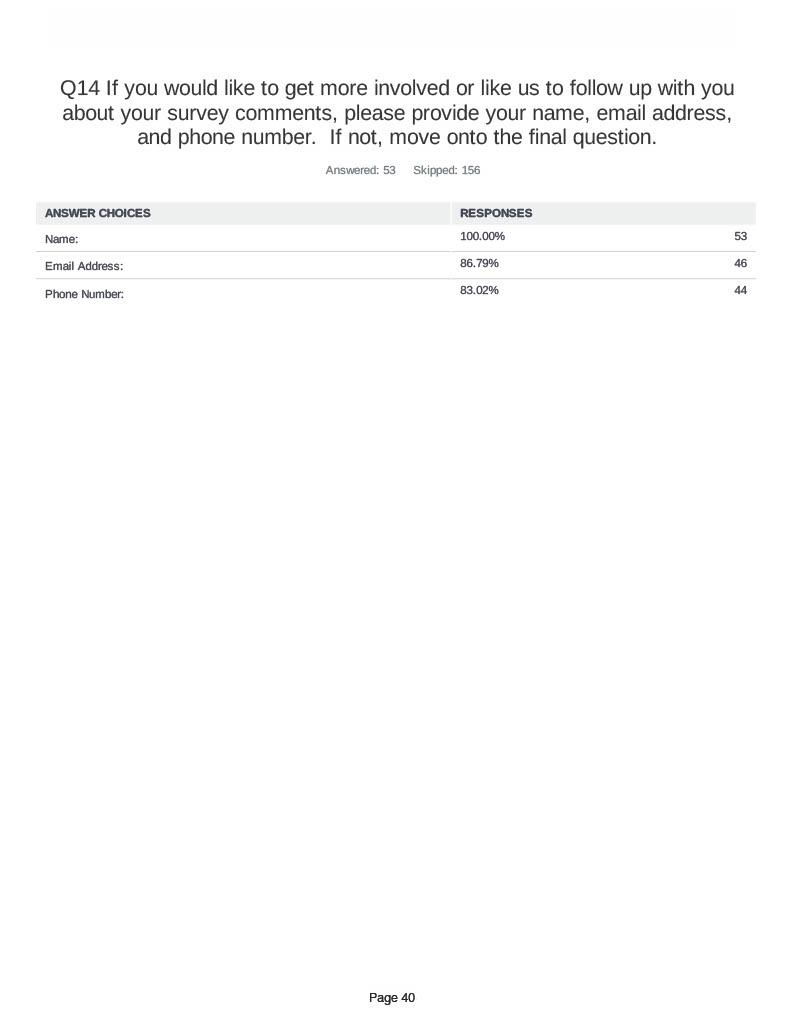
Appendix A Petersham 2024 OSRP pg. 40
Appendix A Petersham 2024 OSRP pg. 41
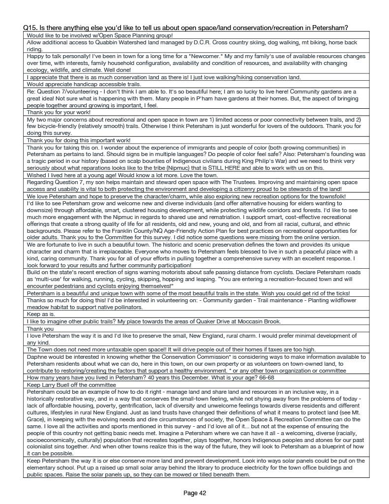
Appendix A Petersham 2024 OSRP pg. 42
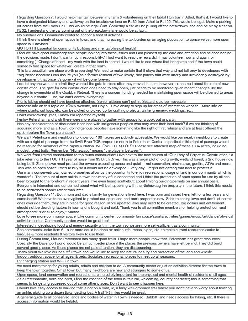
Appendix A Petersham 2024 OSRP pg. 43
Appendix A Petersham 2024 OSRP pg. 44
Appendix B: OSRP Community Engagement Meeting Agendas
Meeting #1, February 3rd, 2024, 2pm-4pm
Community Engagement Schedule
12:30pm Conway Team arrives at Town Hall, Initial set-up by both teams:
• Set up tables and chairs
• Set up entry table
o “What brought you here today?” baskets
o “How important is it…” poster and stickers
• Set up PowerPoint
• Hang maps in central location
• Table Topper #s
Entry engagement: acquisition/conservation question with STICKERS!
• “How important is it to you for the Town to acquire or conserve open space?”
• Box for attendees to add slip of paper answering “Why are you here?”
• Pass out table #s
2pm Core Team introduction: 10 minutes
• Brief individual introductions
• Define OSRP
• Review 2014 OSRP goals and progress since then
• Introduce Conway team
2:10pm Conway Team introduction: 10 minutes
• Brief individual introductions
• Review Survey Results
• Define Open Space & mention maps on the table (Open Space by Level of Protection, Landscape Blocks, Trails)
o “Open space is land that hasn’t been built upon.”
• Core Team distributes vision exercise & pens.
2:20pm First Activity: 5 minutes
• Vision exercise, individual
o rank each component of vision statement as agree/disagree/unsure
o propose written alternatives
• Collect Vision exercise, distribute Open Space by Level of Protection map & Trails map
2:25pm Conway Team introduces next activity: 5 minutes
• Conway team introduces question, explains maps on the table.
Appendix B Petersham 2024 OSRP pg. 1
• Individually think through: WHAT IS YOUR GREATEST CONCERN FOR PETERSHAM REGARDING RECREATION? WHAT IS YOUR GREATEST DESIRE FOR PETERSHAM REGARDING RECREATION? 1 minute
• Turn to your neighbor and discuss the same question: 4 minutes
2:30pm Small group activity: 15minutes
• In small (table-sized) groups, discuss your responses.
• Use stickers on maps to highlight each person’s top concern and desire.
• Attempt to come to consensus over one concern and one desire for the group. This is unlikely to be each person’s individual greatest concern or desire.
• Agree on someone to present your discussion to the group as a whole.
• Core team takes bullet point notes on large pads of paper so it is visible to the group
2:45pm Break: 10 minutes - Core team and Conway team exchange maps (pick up maps with stickers, put down new Open Space by Level of Protection Map and Landscape Blocks map)
2:55pm Switch Theme at tables: 5 minutes
• Define “conservation”
o Protection from development
• Individually think through: WHAT IS YOUR GREATEST CONCERN FOR PETERSHAM REGARDING CONSERVATION? WHAT IS YOUR GREATEST DESIRE FOR PETERSHAM REGARDING CONSERVATION?
• Turn to your neighbor and discuss the same question: 4 minutes
3:00pm Small group activity: 15 minutes
• In small (table-sized) groups, discuss your responses.
• Use stickers on maps to highlight each person’s top concern and desire.
• Attempt to come to consensus over one concern and one desire for the group. This is unlikely to be each person’s individual greatest concern or desire.
• Agree on someone to present your discussion to the group as a whole.
• Core team takes bullet point notes on large pads of paper so it is visible to the group
3:15pm Whole group discussion: 30 minutes
• Each small group’s presenter discusses what they talked about to the group.
• Conway team adds Post-It’s to large maps.
3:45 pm Closing.
• Suggest going back to the vision statement on their own
4:00pm: HOWLING COMMENCES
Meeting #2, March 2nd, 2024, 2:30pm-4:30pm
Appendix B Petersham 2024 OSRP pg. 2
Community Engagement Schedule
2:30pm PowerPoint introduction – Leah, Gina, and Eric
3pm Break out for station activities:
1. Place sticker next to goals you agree with; use sticky notes to add anything
2. Place stickers at trails that need improved access; place stickers in areas that need trail connections
3. Pros and cons for each neighborhood drawing
4. What do you think of build-out map?
5. Eric’s exercise #1?
6. Eric’s exercise #2?
7. Place stickers on each of the maps over areas you’d like to conserve, given proximity to or overlapping with priority habitat
4pm Discussion
Some of the materials used for activities:
1. Goals from the 2014 OSRP
Appendix B Petersham 2024 OSRP pg. 3

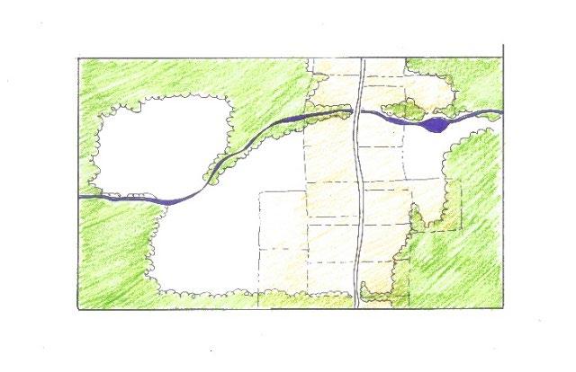
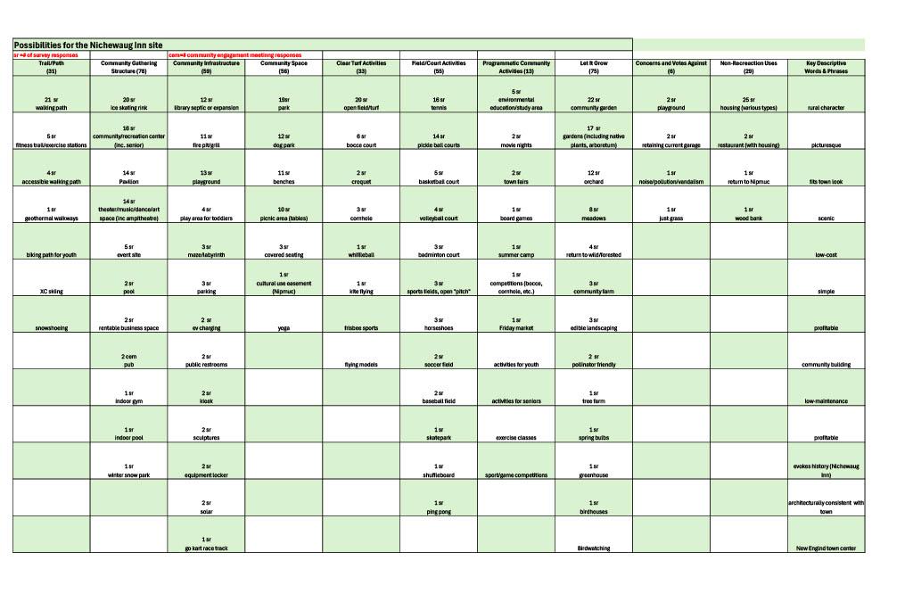
Appendix B Petersham 2024 OSRP pg. 4
2. Neighborhood mock ups
3. Nichewaug bingo
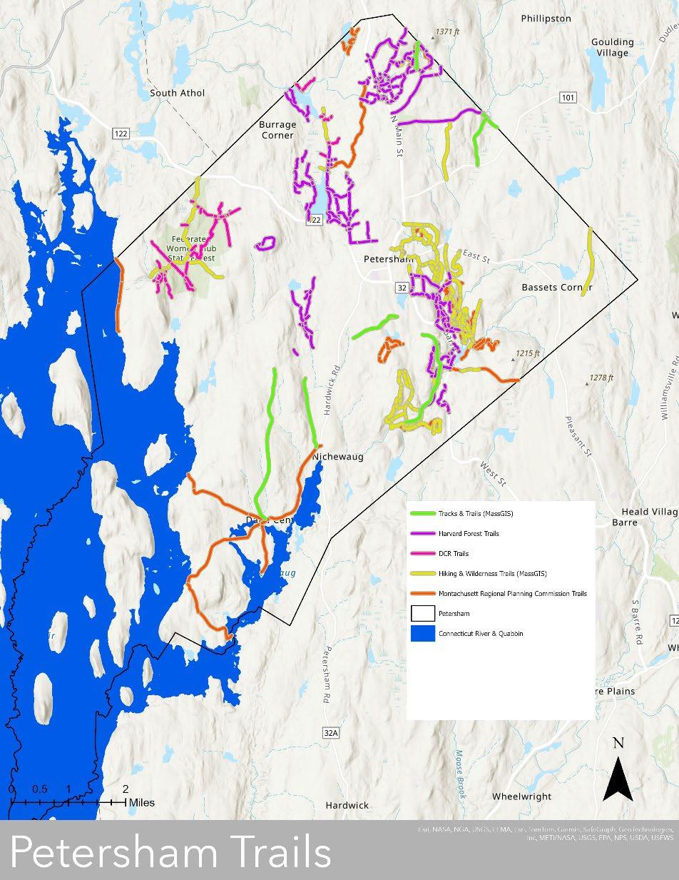
Appendix B Petersham 2024 OSRP pg. 5
4. Trail map

Appendix B Petersham 2024 OSRP pg. 6
5. Build-out map
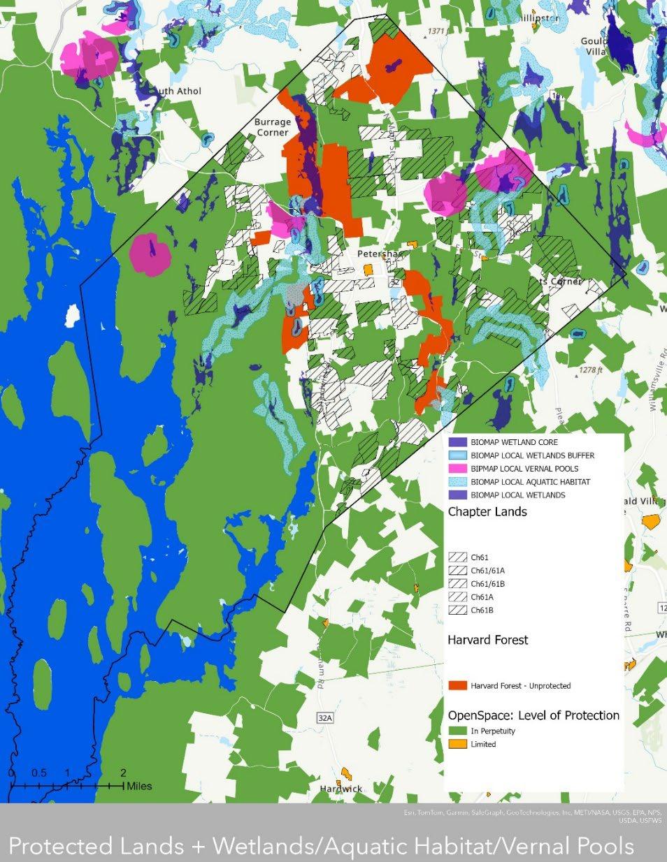
Appendix B Petersham 2024 OSRP pg. 7
6. Priority habitat maps
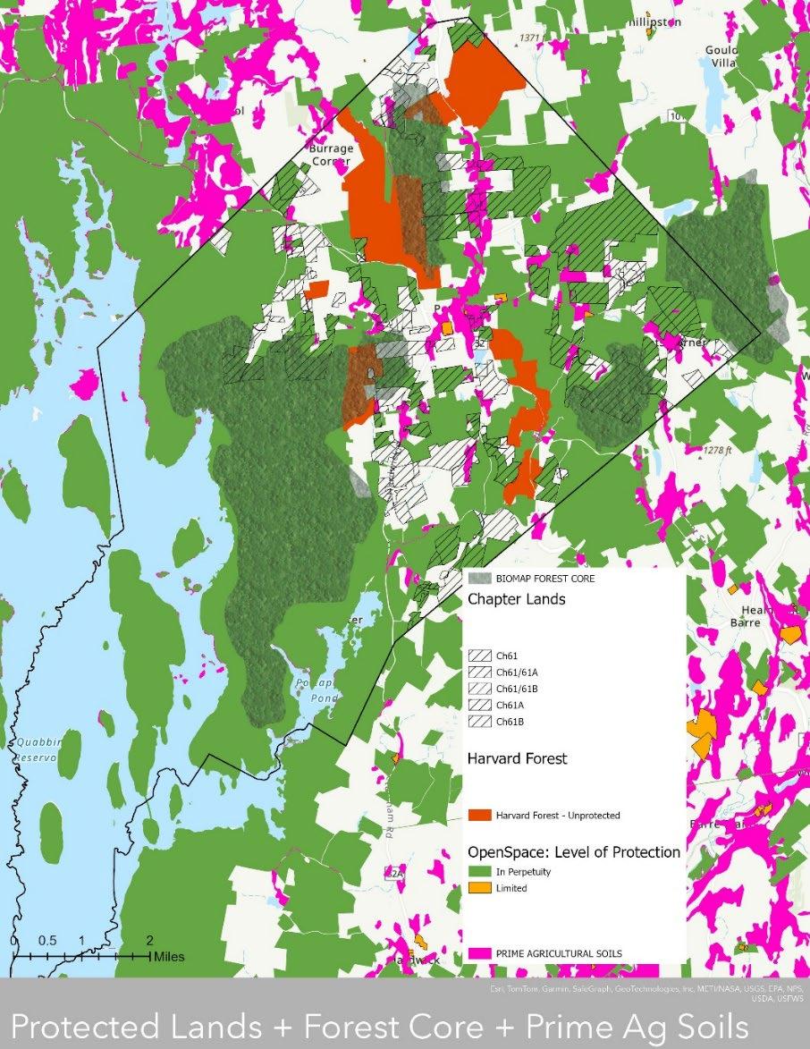
Appendix B Petersham 2024 OSRP pg. 8
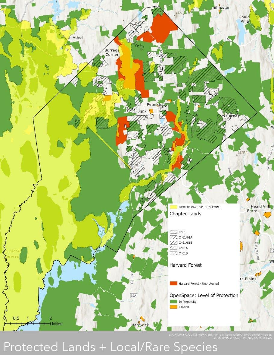
Appendix B Petersham 2024 OSRP pg. 9
Appendix B Petersham 2024 OSRP pg. 10
Appendix C: OSRP Community Engagement Meeting Results
Community Engagement Meeting #1, February 3rd, 2024
Visioning Exercise Results 2/3/2024
The rural character of Petersham should be preserved; development should harmonize with the Town's rural character through careful selection and protection of open space and agricultural lands
The town center should remain a small but friendly gathering space, i.e., mainly residences and civic institutions with a few small businesses catering to townspeople and visitors
Petersham's residents help make the town what it is; choices made about housing and public services should strive to keep Petersham a town that is welcoming to people of different ages, income levels, and cultural backgrounds.
The town will continue to meet the challenges that lie ahead and will work cooperatively to address them; fair but effective planning tools will help prepare the Town to handle future growth pressures, and public facilities should be upgraded in a cost-effective manner that minimizes the tax burden on residents.
The character that makes Petersham special is why people choose to live here.
Residents and visitors like our town without strip malls, tacky signs, endless subdivisions, and wide roads--and want to ensure it stays that way. Twenty years from now, Petersham will still be a unique and beautiful place in which to live.
The first sentence on question #1 sums up my vision!
We should try to attract a little more business, not just limited to what we have today.
agree with caveats agree with caveats
"development should harmonize" yes
Note that this is at odds with preserving certain aspects of "character"
Not sure this is currently true (i.e. house on corner of Spring and West street cultural differences accepted?) only if assimilation is accomplished
"few small businesses" >Growth is important too, Not at the expense of the residents to an insupportable
What is a planning tool?
Yes, but that doesn't mean it will stay exactly the same.
The footprint of working space for town employees should be kept to a minimum. Any projects undertaken should minimize the tax burden, as there are less than 500 households to pay. agree with caveats
Need to get more $ somehow. Grow the tax base or raise taxes...
Should reflect modernization and increase businesses
Appendix C Petersham
OSRP pg. 1
2024
Agree 61 52 47 49 52 Disagree 1 Not Sure 8 14 11 8
Agree with conditions - I agree with this statement if a different term was used than rural characterRural character is often coded racist language for "white"
as long as it keeps the feeling. Could have more businesses Doesn't need to be only residences.
degree. Be sensible and conservative with our money and resources.
tastefully protecting the rural feel and in harmony with what is already here.
We need affordable housing and jobs. (marked unsure)
"minimizes" underlined
Selective increase in density is a must
"public facilities should be upgraded in a cost-effective manner that minimizes the tax burden on residents" > this doesn't particularly speak to me.
What does this mean? We have these alreadylocally and at the legal level if necessary. What is being asked and proposed here? This is a "booby trap" question way too vague -and freighted with socialist policy points.
3/5/24 CEM addition: people are talking like they want a country club - well, country clubs have dues! Need to raise $!
However, there are downsides to the "BRIGADOON" flavor - Also this has the whiff of snob zoning.
Only through targeted zoning and planning tools. Petersham is an island and has a unique position within the greater North Quabbin region.
Appendix
Petersham 2024 OSRP pg. 2
C
Alternative Vision Statements from Residents 2/3/2024
Each community must contribute to the greater Bioregion. Petersham is a place that contributes green space, education, recreation; ____ _____
Open space available to residents to enjoy will be clearly marked and defined to further use.
The town will conserve our forest, wetland, and meadow habitats, and provide trails and information so that everyone can enjoy them. Our native plant landscapes provide habitat for wildlife and pollinators. 4 stickers 3/2 CEM
Petersham should continue to provide environmental protection for the region. 2 stickers 3/2 CEM
Petersham will continue to conserve additional lands and plan for more residential housing in appropriate locations, while protecting the rural character, water quality, and wildlife habitat.
Cluster housing if there was development. Utilize library land (add it) for pavilion or meeting room.
A quiet and peaceful town with open space and public access. 1 sticker 3/2 CEM
A place where the open space and trails are clearly mapped together so residents and visitors can understand and enjoy this unique aspect of the town's legacy. I would like to see the town retain its unique character and landscape. 4 stickers 3/2 CEM
The town should welcome newcomers by offering condensed, sustainable development including lowincome housing while protecting open space and working in harmony with indigenous groups for shared use.
A town that preserve and continue to enhance wildlife conservation as well as agriculture. Inclusion of diverse resident population 3 stickers 3/2 CEM
Protect as much habitat (land) as possible to maintain the rural character of the town. Provide more outdoor and indoor recreational opportunities for all ages to use year round. 1 sticker 3/2 CEM
I would like to see the town remain a small town, but maintain the open space it has. I don't feel we need to acquire more space.
The rural character of Petersham is rooted in a working farm and forest landscape, and before that, in sustaining indigenous communities. These should be preserved as priorities.
Petersham should strive to keep its current essential character. But should also adapt to the post-covid societal changes as it relates to remote work.
Important to preserve + enhance town environment in the face of expected pressures for resource exploitation. 1 sticker 3/2 CEM
In the process of preserving and expanding open space should make sure that this does not mean that the current residences will no longer be able to afford to live here as a result of increase in their taxes.
An inclusive, diverse community with active stewardship of public and private lands and a climate resilient community.
P'town must become a lifelong community. Now it is mainly for school-age families. Some retirement. Little to sustain housing young adults, and difficult for elderly.
Preservation of our rural character is essential The town center is first priority, zoning that allows more dense development in the village and requires more frontage and acreage elsewhere would help.
Appendix C Petersham 2024 OSRP pg. 3
A safe, comfortable, affordable place for all ages. With a few activities to keep people interested and moving.
Petersham will strive to balance conservation space, agricultural space with affordable taxes which support infrastructure, schools and citizen protection.
To maximize use and experience for the public of our vast protected green domains. Build and maintain trail networks so that people can truly prize what we have.
Town should restrict development pressures and will - many projects which change the town character.
Keep up the good work everybody continue to preserve open space limit the # of building permits. 2 sticker 3/2 CEM
The town should serve the needs of its residents and the Commonwealth's residents at large through offering access to healthy ecosystems and welcoming compatible use of public lands and open space, including hunting (but not on Sundays).
A place that needs to be aware of the future without sacrificing the present.
I was struck by the number of survey respondents who were not familiar with rec areas in town - and probably people who didn't respond are even less familiar. So I think before we add more, we should publicize what we have and help people use them.
Develop Nichewaug site for the community.
The Nichewaug propertyI don't think should be left as completely open space. Any open space plan should dovetail with the other planning committees that address issues of housing. In particular the need for senior living in some degree of communal in nature. Some codes are too restrictive for new conservation.
Keeping the town beautiful and accessible. Honoring those that took care of it before anyone called it Petersham.
In general any new stuff should be communal to help people meet and get to know each other.
Carefully zoned clusters of housing should be encouraged rather than single family homes on 2 acre parcels. Police and fire need modernized facilities in the town center. Our library needs room for septic.
Need to include the ability for more affordable housing. The town is beautiful but is aging out.
Petersham should be a place where people of different ages, income levels, and cultural backgrounds feel welcomed. Development should be inclusive but all support nature.
Appendix C Petersham 2024 OSRP pg. 4
Community Engagement
2014 Open Space and Recreation
Goal 1:
Meeting #2, March 2nd, 2024
# stickers of sticker responses on 3/2/24
Protect a significant portion of Petersham’s unprotected open space in order to preserve the Town’s rural character, protect its natural resources, and minimize development in inappropriate areas. 10
Goal 2: Maintain and expand the Town’s “working landscape” of farming and forestry operations and promote ecotourism. 8
Goal 3: Ensure that large portions of the Town’s open space remain open to the public. 6
Goal 4:
Provide adequate access to active recreation facilities for field sports, court sports, skating, and swimming. 6
2014 Natural and Historic Resource Goals # stickers of sticker responses on 3/2/24
Goal 5: Protect the Town’s surface water, ground water, and wetland resources. 7
Goal 6:
Goal 7:
Minimize the destruction and fragmentation of natural ecosystems through carefully targeted open space protection and ecologically-based land development regulations. 9
Manage the Town’s open space to achieve an optimal balance between habitat and water resource conservation and various educational, recreational, and potential revenue generating uses. 4 Goal 8:
Protect historic buildings and landscape features from destruction or inappropriate alteration, and encourage the adaptive reuse of historic buildings. 4
Goal 9:
Provide Natural History Programs at the Petersham Center School and for the community Goal 10: Establish plans and contingencies for mitigating the effects of climate change. 3
Goal 10: Establish plans and contingencies for mitigating the effects of climate change. 6
10a written in: "including tree pests that could decimate street trees (think ALB in Worcester) 1
Improve
Sunset Lane
Barn Pond, Hulbert Pond
Sunset Lane trails: improved signage
Better advertising for town ponds: -Town Barn Pond -Hulberts Pond (South St. Nichewaug) great skating + (maybe canoeing) spring + fall when lilies are gone
Gebo's Creek, California trail on his CR Gebo's Creek California Trail major tributary to the Swift - great trail opp!
Rites of passage for indigenous groups - afford Nipmuc special access (history requires it) to private CR lands places to camp? snowmobile access
Appendix C Petersham 2024 OSRP pg. 5
Goals
Existing Recreation Location Issue
(written in response to snowmobile access) no - sorry! Snowmobiles are super noisy, messy and polluting
New Recreation Opportunities
Location
Activity
Nichiwaug accessible walking paths
PCS basketball & low hoops for kids at PCS
Brown's Pond saw lots of ice fishing on Brown's Pond this year
Davenport Pond accessible trail to Davenport Pond
Harvard Pond good ice-skating this year at Harvard Pond
Final Discussion
Notes
utilize existing gathering spaces before building new ones
library is already a community space
more than just a quite place for reading many activities already happening there potential to coordinate and expand activities needs improved communication to realize potential streamline online communications
fb, websites, Petershamcommon.com importance of viewshed protection
Chapter 61 Lands
Light Pollution
Recreation Director Trail Maintenance
benefit for everyone who sees it
Be aware of parcels put on market
currently no by-law but ZBA (?) has included it in site approvals
Harvard Forest corps to assist with conservation and trail maintenance needs town point person cost, labor
Affordability, Comprehensive (nee Master) Plan
Aging in Place Challenges
walkability in center of town single floor homes need for maintenance, safety
Davenport dam, shed, stage
Appendix
Petersham 2024 OSRP pg. 6
C
Actionability, transparency
some things will need vote, most will need to go through committee, many will have to go through grant process requirng both/either
8k to remove trees
$150k to repair dam, $200k to remove as per Ann Lewis
Nichiwaug Inn site
development is a recurrent theme senior housing should be public use
question of with or without structures create a pro/con list and vote on it
shared water/septic with library Comprehensive Plan useful for figuring out Water Supply
one person (Sue?) categorized potential uses as: developed/business, senior housing, public use with structures, public space no structures create committee to draw up pros aand cons of the 4, make a plan & vote on it
Eric's one-on-one notes
3/2/24 CEM
Mary Ann Importance of gathreing/growing/hunting/fishing food especially focused on wanting to ensure hunting rights
Josh he was struck by # places people aren't familiar with (re: survey Q 6)
idea for interactive map to show locations of different recreation possibilities
John Ewing trails versus "wild area" for hunters
Appendix C Petersham 2024 OSRP pg. 7
Combined Results from Meetings #1 and #2
*The structure of the event was such that the site-specific items were not generally included on the individual sheets.
Appendix C Petersham 2024 OSRP pg. 8
Community
Responses GENERAL TOPIC Group Sheets Individual Sheets Total Responses Community Space 28 20 48 Development 25 19 44 Roads, Sidewalks, Trails 21 31 52 Nichewaug* 21 0 21 habitat 17 17 34 Communication (generally re: access) 16 15 31
Meeting
Appendix D: Core Team Center School Visit
The core team went to the Center School on the morning of Friday, March 1st, and conducted interviews with students about their desires for recreational opportunities in Petersham. While the Conway team was not involved in these interviews, they loved the presentation of the results and wanted to include them here for reference.


Appendix D Petersham 2024 OSRP pg. 1
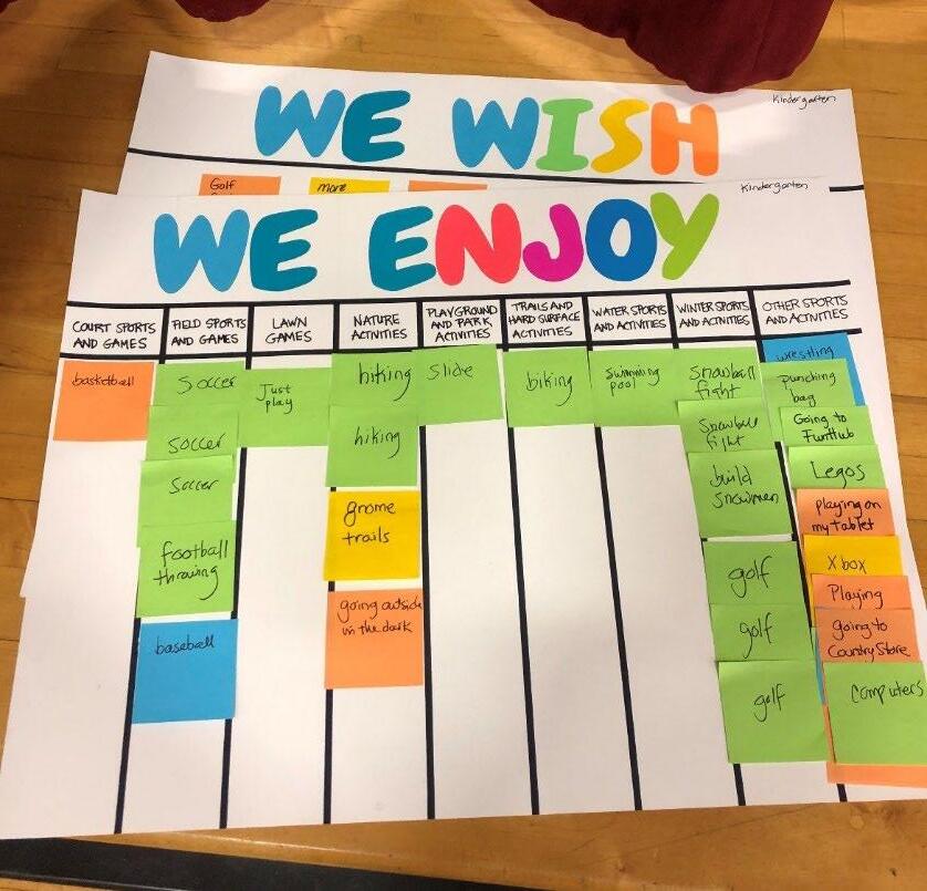
MESSAGES: What do you hope for your town by the year 2030?
2nd Grade 3rd Grade 4th Grade 5th Grade 6th Grade
zoo to be in a band
more animal shelters and animal rescure centers I hope there is more trails in Petersham
healthy environment and place for people who are different and like to walk on all fours as a thereian
zoo to have a car an animal shelter nor more cutting trees add stores
zoo my dog not to be sick I would like to have a place to protect animals trees! more houses
zoo drive a car
more affordable houses more trees and woods and bunnies all over the place I want more places where you can get a job
zoo I hope my family stays healthy ore affordable houses a house trees all Petersham I hope that in 2030 there are more sports becasue right now al there is is soccer and baseball. I also hope that we could have more natures classroom.
I want the town to be safe for the people
I wish in the future I can go to the Florida musuem more affordable houses pride parades
I think we should have more places for kids our age because I keep hearing that there aren't enough spacs for 9-12 year olds.
Appendix D Petersham 2024 OSRP pg. 2
to stay a town to fix my pool country clubs
to be fun animals and plants animal shelter
yes, pride parades I wish for nothing. I think the town is perfect.
I want it to be aa safe place for e.v.e.r.y.o.n.e.
sidewalk sign that flashes when someone presses the button i want to see a nice open space I wish in the future to be wrestling more homeless shelters kind people better intersections in Petersham
open space to be a vet more family owned businesses maybe a bigger community garden
open space
I would be a zookeeper more people/kids
more room protect future
More sidewalks to ride a bike home. Stop signs and traffic lights
sports that cost less money to play smoother roads and streets
I want to see more kids, more animals, more open space, more happy people stop littering keep forests
restaurant animals I want to see it change more, more houses, more people I hope it is clean
clean towns, more trees, being safe outside alone
pet store eagles
I want an indoor/outdoor basketball court and more people science fairs plant trees
Hershey chocolate shop nursing home keep the population the same I hope there is more stuff to do
I thope they do not mix classes like before end of 2024 Dana/Prescott/Petersham School.
a dog park I wish for nursing homes getting more open space a mall keep libraries
dog park fixxing cars more open space a house of leggo Athol should change just a llittle bit.
dogs smart houses open space art! Keep technology the same!
dog city on Mars more greenery and trees, not too many buildings trampoline park The town is perfect kittens and pups be with animals more stores big pool in Petersham
cat
cheetahs/baby cheetahs more stores
I hope there are more sports fields
duck-duck goose game animals extend border by 10 miles so things like Walmart can be built in here horses everywhere
a school save the tigers I want to have a tree park in town cats! space and kindness help eagles more activities like sports teams hamsters invadinfg MA
Appendix D Petersham 2024 OSRP pg. 3
or open gym at the school
I wish there was more school more trees to see ol? gola in the woods
bunnies in every little or big spot in the world
school more bushes indoor swimming pool I like it the way it is I want my parents to let me relax? more animals a pool no Mickey Mouse
sledding more nature more teacher help no more killing animals
ice skating I really want to save the animals
dwarf hamsters
I want to be rich I want to save my stuffed animals pandas everywhere I want to have 1,000,000 dollars I hope they make a cure for covid
Yeezy Slide stores play games like tag
hot tub I wish in the future Fortnite will be the same protect Queen lake more lakes to swim in save monarch butterflies protect animals butterflies protect protect eagles 16 years oldnature
Appendix D Petersham 2024 OSRP pg. 4
Appendix E: Conservation Strategies and Resources
1. Community Preservation Act (M.G.L. Chapter 44B): Becoming a Massachusetts Community Preservation Act community would enable the town to apply for matching grant funds for projects open space preservation, preservation of historic resources, development of affordable housing, and acquisition and development of outdoor recreation facilities. The town would have to do so by passing a referendum which includes approving a real property surcharge of up to 3%, which would fund the program in Petersham. The base state match in November 2023 was 21.02%. https://www.mass.gov/doc/igr-2019-14-community-preservation-fund
2. Cost of Community Services Step by Step Guide: similar to above, this guide from masswoods.org details how to calculate Cost of Community Services ratios. https://masswoods.org/sites/masswoods.org/files/pdf-docppt/COCS%20step%20by%20step%20guide.pdf
3. Costing Municipal Services Workbook and Case Study: This document provides guidelines to determine costs of services provided by the town, factoring in all resources, not just expenditures made. https://www.mass.gov/doc/costing-municipal-servicesworkbook-and-case-study-0/
4. Massachusetts Clean Energy and Climate Plan for 2025 and 2030: “By the end of 2024, the Massachusetts Executive Office of Energy and Environmental Affairs (EEA) will develop and seek to advance new legislation to support the goal of No Net Loss of Forest and Farmland. This will include amendments to the Chapter 61 and 61A currentuse programs to allow parcels of two acres or more to qualify (current tax incentives are for conserving forest land of 10+ acres and farmland of 5+ acres). This will also include a state payment in lieu of taxes (PILOT) bonus to facilitate land protection in rural communities with a low tax base and high percentage of state conservation land.” https://www.mass.gov/info-details/massachusetts-clean-energy-and-climate-planfor-2025-and-2030
5. Massachusetts Community Forest Stewardship Program: Funding is available to assist with carrying out Forest Stewardship Plans. https://www.mass.gov/doc/communityforest-stewardship-grant-program/
6. Massachusetts Division of Fisheries & Wildlife Guidelines for the Certification of Vernal Pool Habitat: Vernal pools that are not certified may also be protected by local conservation commissions or the DEP if credible scientific evidence is presented prior to the end of the appeals period for a Superseding Order of Conditions (OOC) issued by the DEP. https://www.mass.gov/info-details/vernal-pool-certification
7. Massachusetts Joint Bill (H.897/S.447), An Act relative to the Quabbin watershed and regional equity: If passed, the bill would raise PILOT payments in the Quabbin Watershed, which could increase Petersham’s budget and ability to engage in future conservation and recreation efforts. https://malegislature.gov/Bills/193/S447
Appendix E Petersham 2024 OSRP pg. 1
8. Massachusetts Statewide Comprehensive Outdoor Recreation Plan (SCORP): SCORP helps guide the distribution of federal money from the Land and Water Conservation Fund to state agencies and municipalities for the acquisition of open space, renovation of existing parks, development of new parks, and trail development. https://www.mass.gov/doc/massachusetts-statewide-comprehensive-outdoor-recreationplan-2023-scorp-2023/
9. Community Planning Grant Program: Funding is available for a variety of planning purposes, including Master Plans. https://www.mass.gov/doc/fy25-community-planninggrant-program-guidelines/
10. Mass Audubon Barre Conservation Project: Mass Audubon is collaborating with several partners and landowners to permanently protect 973 acres in the vicinity of Rutland Brook Wildlife Sanctuary. https://www.massaudubon.org/our-work/resilient-lands/landconservation/news-project-updates/hawes-hill-urgent-landproject?utm_source=explorations&utm_medium=email&utm_campaign=donate&utm_conte nt=haweshill
11. MassDEP Drinking Water Health and Safety: The Commonwealth of Massachusetts provides a number of resources for protecting drinking water supplies, including lead and https://www.mass.gov/drinking-water-health-safety https://www.mass.gov/lists/drinking-water-contaminants-information-for-the-public https://www.mass.gov/doc/private-well-guidelines/ https://www.mass.gov/how-to/find-a-certified-laboratory-for-water-testing https://eeaonline.eea.state.ma.us/DEP/Labcert/labcert.aspx
Appendix E Petersham 2024 OSRP pg. 2
F: Quabbin Reservoir Watershed System Public Access Policies
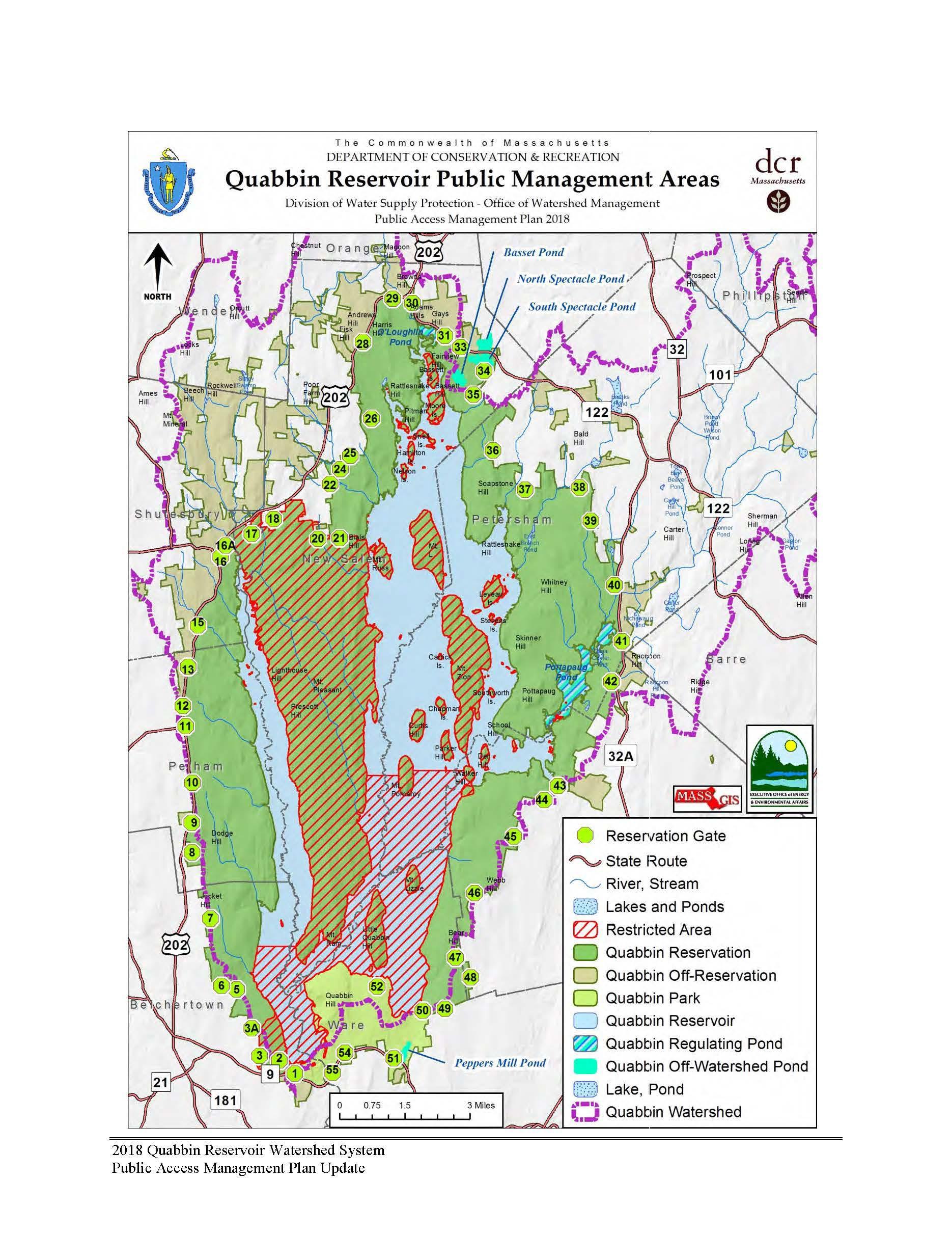
Appendix
Petersham
OSRP pg. 1
F
2024
Appendix
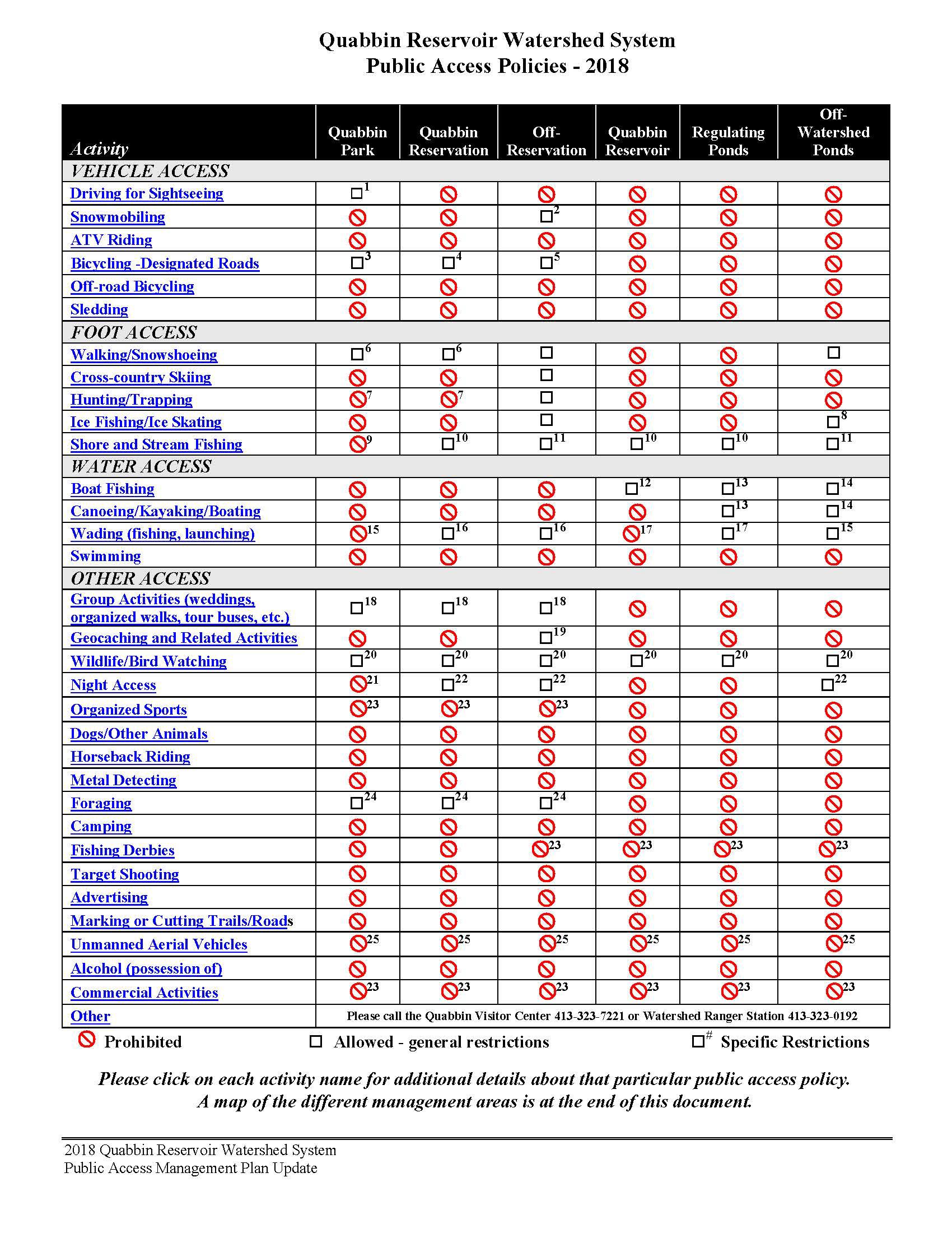
Appendix
Petersham 2024 OSRP pg. 2
F
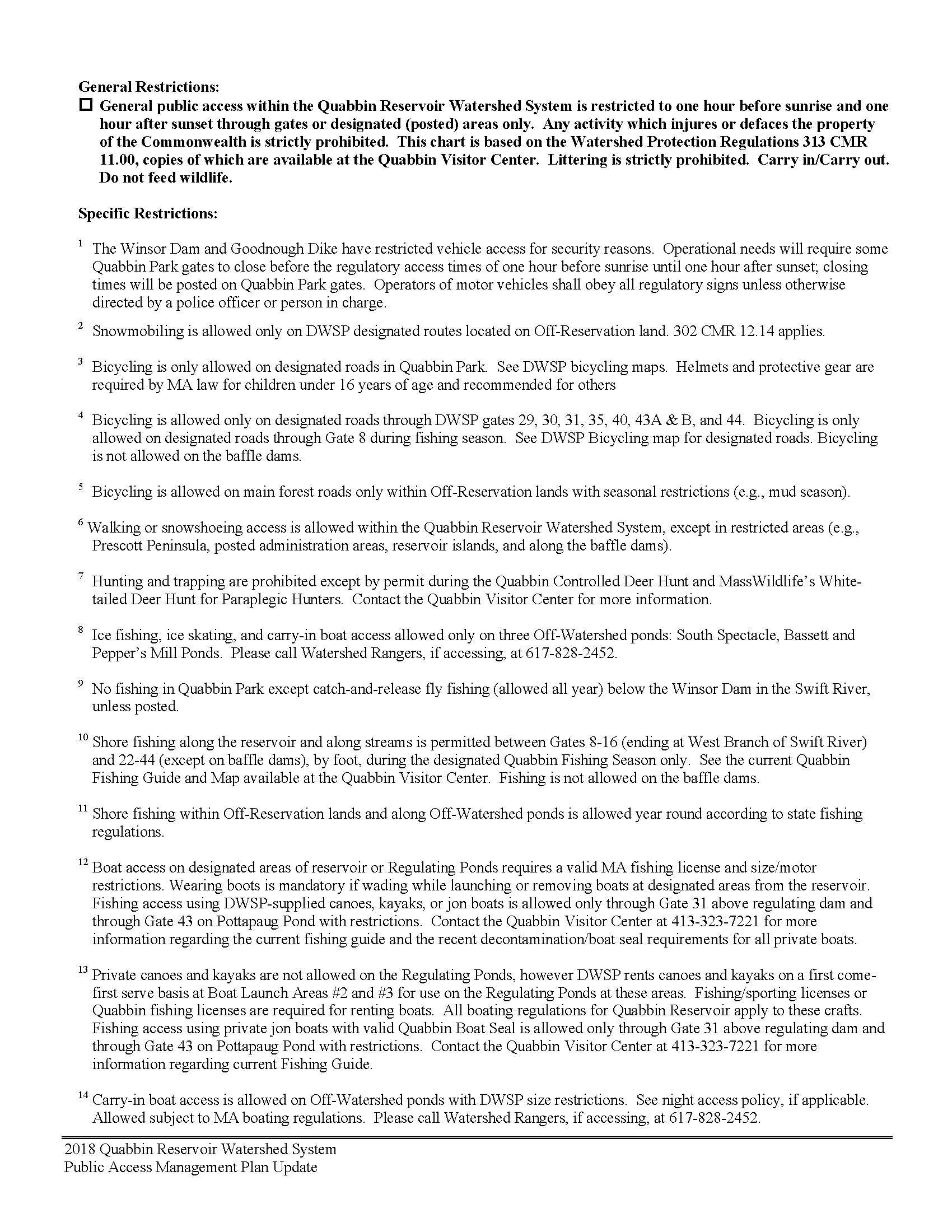
Appendix
Petersham
OSRP pg. 3
F
2024
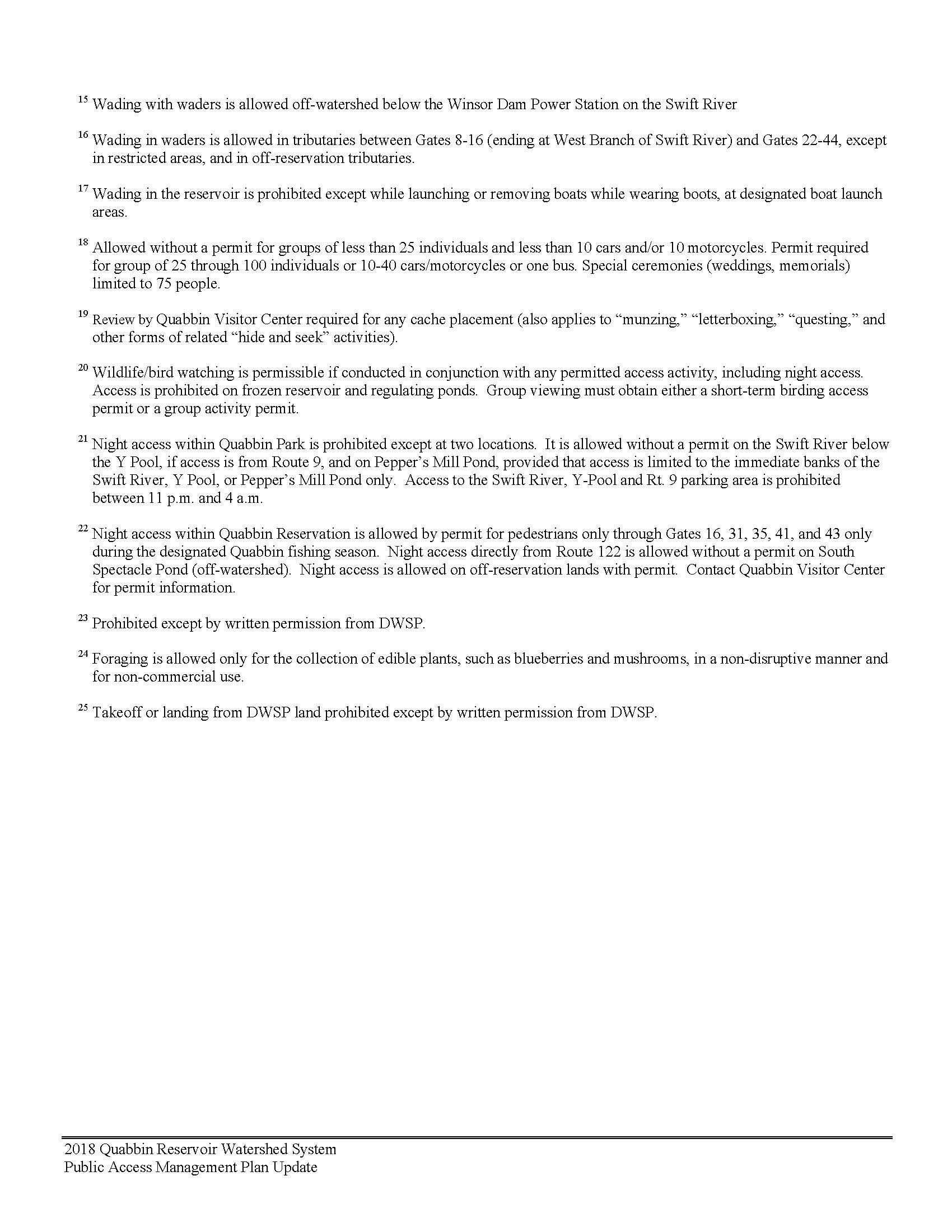
Petersham
OSRP pg. 4
Appendix F
2024
