FEATURED PRODUCTS AT INTERGEO
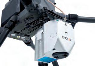
AlphaAir450 UAS Lidar System
N3 IMU GNSS Receiver
The AlphaAir 450 combines a highprecision IMU, industrialgrade GNSS, 3D Lidar scanner and RGB camera to provide an essential combination of long-range scanning and high-resolution imaging. The system achieves an absolute accuracy of 5-10cm and features advanced calibration and point cloud optimization for reduced range noise.
Featuring 1198 channels for full-constellation and full-frequency tracking, an enhanced internal UHF for a working range of up to 15km, an improved high precision IMU allowing for a 60° tilt, low power consumption and over 24 hours of working time, the N3 receiver helps saving energy and brings higher efficiency in conducting your survey tasks.
The AlphaAir 450’s Skyport connection allows direct interfacing with the DJI M300 and M200 V2. Weighing only 1kg, the AA450 can also be mounted on a wide range of multirotor and fixed-wing VTOL drones that can support its weight with dedicated mounts to attach it.
Partnered with SinoGNSS Survey Master field software, ComNav Technology provides you with a fluent and efficient workflow.
View product:
More information at ComNav’s digital Intergeo booth
DJI Phantom 4 RTK Phantom 4 RTK is a surveying drone for photogrammetry applications. It has a centimeter-level positioning system and a high-performance imaging system. It is portable and easy to use, and comprehensively improves the efficiency of aerial surveys. • Max flight time: 30 min • Max transmission range: up to 4.34 miles (7km) • 20 MP 1-inch CMOS Sensor • Built-in RTK module, support PPK • Accurate positioning data with TimeSync • Integrated flight planning with GS RTK app • Complete mapping solution when used with DJI Terra
Meet DJI at booth 20C.02, hall 20
RIEGL VQ-1560II-S Dual Channel Airborne Mapping System With increased laser power, the RIEGL VQ-1560 II-S offers superior performance and highest productivity based on a laser pulse repetition rate of 4MHz (2 x 2MHz) resulting in more than 2.66 million measurements per second on the ground. At typical operating flight altitudes between 500ft up to 12,800ft (ρ≥20%) an even point distribution can be achieved. In combination with different laser power levels, subtle optimization of acquisition parameters is possible which allows to meet specific project requirements in mapping ultra-wide areas, complex environments as well as in corridor mapping applications.
Meet RIEGL at booth 20C.22, hall 20
5
05-06_featuredproductsgedeelte.indd 5
06-09-21 13:46


