UAS FOR MAPPING AND 3D MODELLING
Marlyn
Atlas ppX Marlyn is the latest fixed-wing VTOL mapping and surveying drone made by Atmos UAV, that combines helicopter's flexibility with fixed-wing performance. Taking the best of both an aeroplane and a helicopter, she will help you map more land in less time, with the accuracy you need.
BB4
The ATLAS ppX is currently the most compact member of the C-ASTRAL UAS family weighing only 2.3kg. Developed through a decade of exploitation experience by C-ASTRAL X-WORKS, this hand-launched system has a tactical heritage and can carry multiple modular sensors for precise PPK supported photogrammetry, multispectral and thermal remote sensing.
PHANTOM 4 RTK
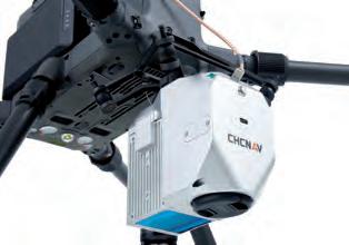
The BB4 is a high-performance quadcopter unmanned aerial system for professional imaging applications. It can carry the CHCNAV Lidar scanners with DSRL cameras for high-accuracy 3D point cloud generation or oblique cameras for 3D photogrammetry. With a setup time of only two minutes, the versatile BB4 offers up to 55 minutes of flight time with a 1kg payload and up to 40 minutes with a 5kg payload. The drone is controlled with the DJI Lightbridge 2 flight controller and a 5km operating range.
Matrice 300 RTK The Matrice 300 RTK is DJI’s latest commercial drone platform that takes inspiration from modern aviation systems. Offering up to 55 minutes of flight time, advanced AI capabilities, a six directional sensing system and more, the M300 RTK sets a whole new standard by combining intelligence with high-performance and unrivalled reliability.
DJI has rethought its drone technology from the ground up, revolutionizing its systems to achieve a new standard for drone accuracy, offering Phantom 4 RTK customers centimetre-accurate data while requiring fewer ground control points. Upgrade your next mapping mission with the Phantom 4 RTK, the most compact and accurate low altitude mapping solution.
Drone Solution A fully integrated and powerful drone solution offering easy and safe aerial access to challenging areas, a larger surface coverage in a single flight, higher resolution images, and an opportunity to acquire aerial data with a cost-effective and efficient tool. Phase One’s Drone Solution combines state-of-the-art hardware and software components, including integration of either the iXM100MP and iXM50MP digital aerial camera and a choice of 4 RSM lenses.
80
80-81_productenuasformappingand3dmodelling.indd 80
06-09-21 15:16


