UAS LIDAR SYSTEMS
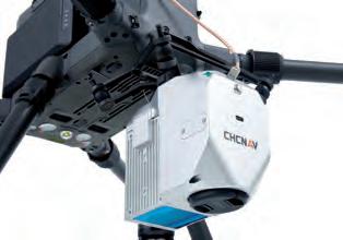
Scanfly ULTRA Scanfly ULTRA is designed to exceed the demands of the most challenging real-world 3D mobile mapping applications, with a range of up to 200 meters. Scanfly has been designed to simplify the user experience, without any compromise in the measuring performance. Every detail, from the component selection to the graphical user interface, has been inspired by this philosophy.
AlphaAir450 The AlphaAir 450 (AA450) is a major breakthrough in 3D mobile mapping technology, allowing its use by non-professional users in geospatial reality capture applications and to those who have never been able to access such technology before. The AlphaAir 450 offers ease of use and high precision capabilities at an affordable price point.
Scanfly XT Scanfly XT delivers extremely resolute and definite point clouds, making it the ideal choice for mapping at longer ranges and higher speeds. Scanfly XT is the payload Lidar that is not only applicable to UAS. By increasing the longitudinal resolution at a higher speed, the XT is a perfect fit for land vehicle installation as well.
Zenmuse L1 The Zenmuse L1 integrates a Livox Lidar module, a high-accuracy IMU, and a camera with a 1-inch CMOS on a 3-axis stabilized gimbal. When used with Matrice 300 RTK and DJI Terra, the L1 forms a complete solution that gives you real-time 3D data throughout the day, efficiently capturing the details of complex structures and delivering highly accurate reconstructed models.
Hovermap HF1
True View 635/640
Hovermap is a plug-and-play payload that is easily integrated into a range of UAVs to provide them with advanced mapping and autonomy capabilities. This includes collision avoidance and GPS-denied flight, allowing drones to be flown safely underground, indoors or up close to structures to inspect and map them. Hovermap is a SLAM-based system, allowing accurate mobile Lidar mapping even when GPS is not available. It can also be used as a walking or backpack mapping system.
The True View 635/640 is a compact, survey-grade 3D Imaging Sensor (‘3DIS’) designed for small unmanned aerial systems (sUAS or drone). It comprises a survey-grade RIEGL laser scanner with dual photogrammetric cameras that have been carefully configured to provide a fused Lidar/ imagery field of view (FOV). The system includes full post-processing software that generates a ray-traced 3D colorized point cloud and geocoded images.
85
85-86-87_productenuaslidarsystems.indd 85
07-09-21 11:47


