3 minute read
Farm-to-Grid
History of the Urban Street Grid
At the time the British took over Dutch Nieuw Nederland in 1664, there were already six towns in what would become Kings County, or Brooklyn as we know it today. The oldest, Gravesend, was founded by an Englishwoman, Lady Deborah Moody, in 1645, and Breuckelen, which encompassed our study area, was founded in 1646.1 The first private road in Breuckelen was a country lane called District Street, today known as Atlantic Avenue, which ended on the East River at Ralph Patchen’s farm. During the 1700s it was the southernmost boundary of the Village of Brooklyn.2 Originally, all of the towns in what is now Brooklyn set up their own grid system, which meant that streets and avenues were not aligned from town to town.
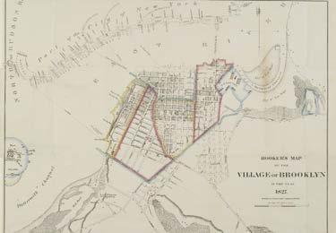
In 1816, the Brooklyn charter was approved and the Village of Brooklyn. The Village of Brooklyn included the small area bound by Atlantic Avenue. At the same time, Red Hook Lance, the US Navy Yard within the Town of Brooklyn, was officially incorporated as part of New York. With this charter the official boundaries of the village were established, sidewalks were repaired and extended, houses were numbered, a fire protection system was designed, and the first maps were drawn.3 According to Chapter 95 of the Laws of 1816, the boundaries were defined as “beginning at the public landing, south of Pierpont’s distillery, formerly the property of Philip Livingston, deceased, on the East River, thence running along the public road leading from said landing, to its intersection with Red Hook lane, thence along said Red Hook lane to where it intersects the Jamaica Turnpike road, thence a northeast course to the head of the Walleboght mill pond, thence down the East River to the place of beginning.”4 Section 18 of the Act also required the Trustees to survey the land and create a map of the village outlining the streets, roads, and alleys that were to be permanently laid out. The official map was adopted on April 8, 1819. However, with the opening the Fulton Ferry and the subsequent rapid pace of urbanization, the recently adopted street map became obsolete.5 So in 1824, a new set of laws were passed, authorizing the Trustees to widen and alter all public roads, streets, and highways as they saw fit, but not exceeding sixty feet.6 In 1827 the village was divided into five districts, and in 1833 the President and Trustees were authorized to lay out and open new streets, avenues, or squares within the Village, and to widen or extend any old street.7
In 1834 the City of Brooklyn was incorporated, comprising the Village and Town of Brooklyn. At the same time, under Chapter 92 of the 1834 Laws, Brooklyn was divided into nine wards. The same year, the new city requested that the state conduct a survey of the surrounding countryside in order to lay out the streets, avenues, and public squares. In 1935, under Chapter 129, the Common Council were authorized to lay out a new plan with regular streets, no more than 100 feet in width.8 The new map was completed in 1839 and followed the example put forth by the Commissioners’ Plan of 1811 for the Manhattan grid. The plan was based on a rectangular grid crossed by several major diagonal avenues.9
Source: New York :William Hooker, 1827. Brooklyn Historical Society Map Collecztion.
1 http://ny.curbed.com/2014/7/24/10069912/brooklyns-evolution-from-small-town-to-big-city-to-borough 2 http://ny.curbed.com/2014/7/24/10069912/brooklyns-evolution-from-small-town-to-big-city-to-borough 3 http://thesixthborough.weebly.com/history-of-fulton-ferry-landing.html 4 John Jr. Dikeman, The Brooklyn Compendium, Compiled by the late John Dikeman, Jr., Showing the Opening, Closing and alterations in the lines of the various streets, avenues, &c., In the city of Brooklyn, with other information connected therewith, from the year 1819 down, to the date of the close of the compilation, together with Important Data Relative to Grants of Land Under Water, Ferry Rights, Etc.,Order of the Brooklyn Common Council, 1870. pg. 5. 5 Ibid. 6 Dikeman, 6. 7 ibid. 8 ibid. 9 http://thesixthborough.weebly.com/history-of-fulton-ferry-landing.html "Hooker’s New Pocket Plan of the Village of Brooklyn."


