
Pamela Conrad / Michael Blier
Envision Resilience: Imagining a Future Waterfront for Portland, Maine


Pamela Conrad / Michael Blier
Envision Resilience: Imagining a Future Waterfront for Portland, Maine
Pamela
Shan He, Sakiko Isomichi, Alexandra Kupi 15 Ecology + Habitat
Qijia Chen, Garrett Craig-Lucas,Tim Jia
17 Demographics + Cultural Landmarks
Willa DeBoom, Jein Park, Kati Wiese
19 Immigration Housing + Contamination
Shan He, Sakiko Isomichi, Alexandra Kupi
21 Heat Risks + Rising Temperatures
Willa DeBoom, Jein Park, Kati Wiese 23 Compound Flooding
Qijia Chen, Garrett Craig-Lucas,Tim Jia
33 Ownership + Land Use
Qijia Chen, Sakiko Isomichi, Alexandra Kupi
Visit 35 Portland, Maine 10/1-10/03
A Community Conversation
Sakiko Isomichi, Tim Jia, Kati Wiese
Qijia
Forest Lab-Adapting and Growing with Forests
the Block-Reclaiming Portland’s Gateway + Sustaining Community Resilience
Kati Wiese
Shoals-Stewarding Social Infrastructure in Bell Buoy Park
Qijia Chen
Sakiko Isomichi
and Working with WaterResilient Housing For Fisherfolk Alex Kupi
Hub- A Commercial District Connecting Islanders,
Jein Park
Willa DeBoom
and Tourists
Envision Resilience: Imagining a Future Waterfront for Portland, Maine
Envision Resilience is a semester-long multi-university design studio that calls on students to reimagine coastal communities and propose imaginative solutions to the current and future impact of sea level rise.
In the Fall 2024, the Harvard GSD participated in the Envision Resilience Challenge developed by Remain, which connects academia, local leadership and community members, while inspiring coastal communities to envision innovative approaches to the impacts of climate change. “The program allows communities to engage in hopeful and meaningful conversations about the future and inspires real action in resilience projects and fosters the next generation of leaders to think interconnectedly and holistically about climate challenges through design and innovation.”
“Like coastal communities around the world, Portland and South Portland are at the forefront of a changing climate. The Gulf of Maine waters are warming, and sea levels are rising at three to four times the global average. Winter storms this year have flooded downtowns, damaged wharves, washed away historic structures and set record high tides. University teams will be tasked with tackling these challenges as they design novel ways of living under future conditions that address the intersecting issues of affordable housing, transportation, urban heat, equity, local industry and ecology.” – Envision Resilience, May 8, 2024
Through in-depth research and analysis, students explored coastal adaptation strategies potentially applicable to Portland’s working waterfront. Community engagement, guest expert interaction, along with collaboration with the other academic institutions facilitated a unique opportunity and encourage creative
design interventions that seek to address the key challenges of our time.
Three key principles guided the GSD studio:
Community and Historic Ecology: The studio’s approach for Portland’s Working Waterfront centered on community engagement and ecological understanding. Through a participatory design process, the studio supported hands-on engagement with the community and students.
Local and international experts and leaders shared learnings, deeply embedding the studio in the cultural and ecological fabric of the region. The students undertook a thorough study of natural and cultural processes at various scales, ensuring a comprehensive understanding of the landscape’s potential for adaptation. By fostering dialogue and collaboration, the studio supported the students in co-creating solutions that honor the waterfront’s heritage while embracing its future potential.
Risk Responsive: In navigating the complex challenges of climate change, the studio’s collaborative approach was rooted in risk responsiveness. Through mapping, the students assessed climate risks and impacts on both communities and ecosystems. Through a climate multi-hazard risk assessment, the students shared insights with stakeholders, fostering knowledge exchange. Additionally, the students explored comprehensive compound flooding models and identified scalable adaptation measures tailored to Portland’s diverse working waterfront. Leveraging resources and insights from invited experts, the studio assembled a comprehensive toolkit of adaptation strategies. The goal was to equip the students and community with the knowledge and resources needed to navigate climate risks effectively, ensuring the long-term resilience of Portland’s future waterfront.
Transformative Planning and Design:
While the studio was rooted in transformative planning and design, students were charged with identifying performative interventions ranging from immediate actions with minimal resources to long-term strategic initiatives. Students looked to catalyze change at both the local and regional levels and were encouraged to develop holistic spatial solutions that mitigate risks while maximizing benefits for community health, biodiversity, heat reduction, water conservation, and carbon drawdown. Through innovative tools such as the Climate Positive Design Pathfinder, the students quantified the carbon impact of their interventions. Through compelling visual representation and communication techniques, the studio outcomes strive to inspire collective action that can be implemented in Portland’s future waterfront.
Pamela Conrad Studio Description
The Harvard Graduate School of Design studio is comprised of landscape architecture, architecture, and urban planning graduate students who focused on developing coastal adaptation strategies for Portland, Maine’s working waterfront.
The semester began with an assessment of existing conditions, demographics, infrastructure, ecology and future risks due to increasing flooding, temperature increases, and immigration. In addition to meeting with various stakeholders, the students curated a pop-up event at the Gulf of Maine Research Institute in October 2024 to hear from the community directly.
Based on this feedback, the studio developed potential adaptation strategies and a toolkit of various techniques that can be implemented over time. Maintaining the historic character and performative functions of the working waterfront while ensuring long-term resilience were driving goals.
The near-term approach identifies ways to Protect the working waterfront from 1.5 feet of sea level rise and a one-percent annual chance storm, estimated in the “Maine Won’t WaitPrepare” state guidance 2050 timeframe. These techniques include wet and dry floodproofing of the most vulnerable and critical assets and transitioning fixed over-water structures nearing the end of their useful lifespan into refurbished floating elements. Incorporating green infrastructure into Commercial Street also supports an urban forestry program that will alleviate inland flooding and increasing temperatures.
The mid-term Integrate strategy primarily relies on gently sloping Commercial Street up towards Casco Bay, protecting from 4 feet of sea level rise combined with a one-percent annual chance storm, aligning with the “Maine Won’t WaitCommit” scenario for 2100. This roadway slopes back down to the pier extensions, maintaining critical vehicular access for the working water-
front functions while continuing to transition facilities into more adaptable ones. The new Commercial Street responds to community requests by incorporating a two-way cycle track, additional shade protection from summer heat, and the potential for public transit.
The long-term Embrace approach plans for a future of 8.8 feet of sea level rise, established by “Maine Won’t Wait - Prepare” actions for the year 2120. With this future scenario, the daily Casco Bay water level is near the historic shoreline of Fore Street today. With a thoughtful transition protecting the most historic assets with a living shoreline berm over time, the working waterfront transitions into a maritime district of the future. Considerations include incorporating aquaculture for harvesting species that will thrive in a warmer climate, intertidal habitats that will clean the water, and more opportunities for living, working, navigating, and enjoying the waterfront.
All approaches include the consideration for a low-carbon resilient future that imagines re-use of buildings and materials while preserving Portland’s food and craft culture. The plan embraces change for floating structures, much needed housing, and an autonomous private and public vehicle transition that supports a more robust urban forest. These strategies will actively contribute to cooling, increasing biodiversity, and supporting a more equitable future for all residents and visitors to Portland, Maine and its surrounds.
Studio Instructors
Pamela Conrad / Michael Blier
Teaching Assistant
Shan He
Students
Qijia Chen, Garrett Craig-Lucas, Willa DeBoom, Shan He, Sakiko Isomichi, Tim Jia, Alexandra Kupi, Jein Park, Kati Wiese
Mid Review Critics
Curtis Bohlen, Sara Carr, Ryan Kanteres, Amy Magida, Milan Nevajda, Julia Tate, Heather Walters
Final Review Critics
Julia Czerniak, Matthew Cunningham, Kristin Frederickson, Matt Littell, Lauren Stimson
Cartography
Atlas of Portland, Maine
Preliminary Design Research
This atlas serves as a foundational resource for understanding Portland, Maine, as the students prepared for an in-depth field study. Created a month prior to the initial site visit, it integrates Geographic Information System (GIS) analysis and preliminary research to highlight Portland’s diverse assets, vulnerabilities, and opportunities for future development.
The atlas is structured around key categories: ecological, social, economic, and human settlement systems. It identifies existing and potential assets, such as marine and urban ecologies, cultural and recreational spaces, and critical infrastructure. It also addresses pressing risks, including flooding, heat, and social challenges like immigration and affordable housing. By examining the interplay between these elements, the studio aim is to establish a strategic framework for resilience and sustainable growth.
This preparatory work equipped the team with a nuanced understanding of Portland’s current conditions and potential trajectories, ensuring the design proposals are well informed and impactful.
Economics and Infrastructure
A comprehensive overview of Portland, Maine, highlights its maritime assets, critical facilities, land use, and transportation networks. The yellow line marks Fore Street, a historic waterfront corridor that predates the 1850s infill project, reflecting the city’s evolving relationship with its coastline. Key transportation features include the Downeaster rail line and the public bus system, offering insights into how Portland is connected and navigated today.
Historic rail lines, marked alongside active and inactive infrastructure, reveal how Portland’s transportation systems have transformed over time. The map also outlines the Casco Bay ferry routes, residential zoning, and historic districts, emphasizing the city’s layered urban fabric.


Shan He Sakiko Isomichi Alexandra Kupi
Created as part of the preparatory research phase, this map offers a foundational understanding of Portland’s past and present infrastructure to inform future design interventions and urban development planning.


Ecology and Habitat
Portland’s rich ecological diversity, spans aquatic, terrestrial, amphibian, and avian systems. Key bird habitats along shorelines include marshlands and intertidal zones, with species like the Great Egret, Herring Gull, and Northern Mockingbird. The map emphasizes the benefits of native tree species, such as Red Maple and White Pine, in supporting bird diversity within urban and coastal environments.
Portland’s unique position offers the potential to integrate its working waterfront with the surrounding park system, forming a cohesive “green loop” that enhances ecological connectivity.

Qijia Chen, Garrett Craig-Lucas Tim Jia
By understanding the interplay of marine, intertidal, and urban areas, this map serves as a foundation for exploring how urban open spaces can sustain shorebirds and broader coastal ecosystems. It reflects the dynamic relationship between Portland’s historic shoreline, modern development, and natural habitats, offering insights for resilient urban ecological planning.

Demographics and Cultural Landmarks
This map depicts Portland’s demographic distribution and cultural landmarks. With a population of 68,300, predominantly white, and an average age of 37.6, the city blends historic charm with modern life. Key institutions like the University of Southern Maine and various cultural, artistic, and scientific centers define its character.
Portland’s coastline, adorned with fall goldenrods, features a working waterfront marked by lobster pots, eateries, and historic piers. The city is rich in islander traditions, artisanal crafts, and historic landmarks, reflecting its vibrant cultural heritage. This map connects demographic insights with urban assets, illustrating Portland’s role as a cultural and educational hub.


Willa DeBoom
Park Kati Wiese


Jein


Immigration Housing and Contamination
Portland faces critical issues including a growing housing crisis, an immigration boom, and environmental contamination concentrated around the working waterfront. The city’s population growth, driven by immigration, is projected to double the number of refugees compared to previous years. However, Portland currently lacks a long-term strategy to address housing demands, as illustrated by the purple circles marking approved market-rate and affordable units in 2023. The housing shortage and homelessness crisis are compounded by the need for innovative building typologies that address sea-level rise while maintaining public engagement in urban spaces. Meanwhile, the waterfront faces contamination risks from stormwater runoff and outdated combined sewer systems, which pose a threat of spreading toxins inland due to rising sea levels.

Shan He Sakiko Isomichi
Alexandra Kupi
Initiatives such as soil dredging and sustainability ordinances are beginning to tackle these issues. This map frames the complex interplay of population growth, housing needs, and environmental sustainability in Portland’s future planning efforts.

Heat Risks and Rising Temperatures
This map illustrates the escalating risks associated with rising sea and land surface temperatures in Portland. By 2100, temperatures are projected to increase by 5.4 to 9.9°F, heavily impacting species migration, development, and the urban environment. The working waterfront, with its large impervious paved areas, remains particularly vulnerable to extreme heat.
Near-term projections show a 2 to 3°F rise in land temperatures by 2030, leading to noticeably hotter summers and more frequent heatwaves. By 2120, under high-emission scenarios, land temperatures could rise by 6 to 11°F, intensifying risks to vulnerable populations and straining infrastructure unprepared for extreme heat.
Willa DeBoom


Jein Park
Kati Wiese
The map also highlights the interplay between canopy coverage and temperature regulation, emphasizing the importance of mitigation strategies. Immediate action to reduce emissions and adapt urban systems is critical to safeguarding Portland’s ecological and social resilience against the growing threat of heat and climate change.


Compound Flooding
This map highlights Portland’s vulnerability to compound flooding caused by rising sea levels and stormwater runoff. With sea levels projected to rise by up to 8.8 feet by 2120, flooding risks extend beyond the waterfront to inland areas, particularly during major storms. The arrows indicate water flow pathways, while red dots mark stormwater outfall points, emphasizing areas at risk of overflow during severe weather events. Recent storms, such as those in January 2024, have exacerbated flooding, with rising seas blocking storm drains and outfalls. Degrading shoreline infrastructure, including failed sea walls and sinkholes, further compounds the risk to vulnerable zones like the Old Port. This map underscores the urgent need for improved stormwater management and resilient infrastructure to mitigate the growing threat of flood damage in Portland’s coastal and urban areas.
Qijia Chen, Garrett Craig-Lucas Tim Jia


Downtown Portland Waterfront Projected Sea Level Rise Impacts
for 2050, 2100, and 2120
This series of detailed maps illustrates the anticipated impacts of sea level rise (SLR) on Portland’s downtown waterfront for the years 2050, 2100, and 2120. According to the Maine Climate Council, the state should plan for 1.5 feet of SLR by 2050, 3.9 feet by 2100 with likely emissions scenarios, and prepare for 8.8 feet in 2120 with a high emissions scenario. These projections are based on historical data from tide gauges in Portland, Bar Harbor, and Eastport, as well as scenarios established by NOAA. These maps highlight areas susceptible to tidal inundation and storm surge under each scenario, emphasizing the increasing vulnerability of critical infrastructure, historic sites, and residential neighborhoods. Notably, the Old Port district and Bayside neighborhood are at heightened risk, with projections indicating significant flooding even with moderate SLR.
The 2024 Portland flood, which resulted from heavy rainfall coinciding with a record-high tide of 14.57 feet, underscores the city’s susceptibility to such events. This incident serves as a stark reminder of the potential future impacts depicted in these maps. By visualizing these scenarios, the maps aim to inform urban planning and resilience strategies, guiding efforts to mitigate the adverse effects of sea level rise on Portland’s waterfront communities.
Sea Level Rise 2050
1.5’ sea level rise (SLR) “ Maine Won’t Wait, Commit” scenario with a 1% annual flood and mean higher high water (MHHW).
+6.15 MHHW 2050, +10.85 1% annual flood = +11.85 design flood elevation (DFE) with 1’ freeboard minimum


The light blue overlay highlights critical infrastructure, historic designations, public space, and connectivity that be impacted by sea level rise (1.5’) and a 1% annual flood in 2050. This map informs the questions of when, how high, and what to protect.


Sea Level Rise 2100
3.9’ sea level rise (SLR) “ Maine Won’t Wait, Commit” scenario with a 1% annual flood and mean higher high water (MHHW).
+8.65 MHHW 2100, +13.35 1% annual flood = +14.45 design flood elevation (DFE) with 1’ freeboard minimum


Commercial Street is progressively inundated by the rising seas in 2100, projected as 3.9’ by the “Commit” scenario in the State’s Action Plan “Maine Won’t Wait”. The light blue tone indicates the impact area with a 1% annual chance flood.


Sea Level Rise 2120
8.8’ sea level rise (SLR) “ Maine Won’t Wait, Prepare” scenario with a 1% annual flood and mean higher high water (MHHW).
+13.45 MHHW 2120, +18.15 1% annual flood = +19.15 design flood elevation (DFE) with 1’ freeboard minimum


By 2120, 8.8’ of sea level rise plus a 1% annual chance storm is projected to reach Fore Street, Portland’s historic shoreline before the waterfront was filled. State guidance defines this area in blue as the “Prepare” scenario in “Maine Won’t Wait”.


Ownership and Land Use
These two maps explore the complex ownership and diverse land uses of Portland’s waterfront. The area hosts a mix of critical maritime infrastructure (Portland Pilots, ice plants), housing (Chandler’s Wharf), and offices ranging from large firms like Peirce Atwood to small offices above bait processing facilities. The waterfront operates as an interconnected system, where each element depends on the others, a fragility highlighted during our walk with Bill. Zoning debates have shaped the waterfront’s history, including the 1987 moratorium that restricted non-marine uses after the controversial development of Chandler’s Wharf residences. Today, non-maritime uses are limited to 125 feet from Commercial Street. The city manages four piers, with the Maine State Pier as the largest, while ongoing efforts focus on repairing facilities and preserving historic structures like wooden piles and dry-laid rock sea walls.


Portland, Maine
9.30-10.03
Field Trip
Exploring Resilience and Community Visions
The field trip to Portland, Maine, from September 30 to October 3, 2024, supported a rich tapestry of discovery, collaboration, and immersion into the challenges and opportunities facing this historic coastal city. The journey aimed to explore Portland’s strategies for addressing climate change, urban development, and community aspirations.
One highlight was the exploration of Portland’s working waterfront, a dynamic space that balances maritime industries, residential living, and office spaces. Led by Bill Needleman, Waterfront Coordinator for the City of Portland, the group learned about the intricate and interconnected systems that make the waterfront vital.

Top: Walking Along Portland Waterfront,
Photography by Shan He
Tamaki from I.S.F. Trading Co., shared fascinating insights into the global seafood trade. The local sea monger introduced delicate sea urchins, which were sampled in a traditional Japanese style, a moment that brought international flavors into the learning experience.
Our group took time to photograph the vibrant waterfront, map its pathways, and create detailed construction diagrams to understand the piling systems supporting the wharves. The team also visited public spaces, such as Bell Buoy Park, Fort Allen Park, and Back Cove Park, where the juxtaposition of natural beauty and urban life painted a vivid picture of Portland’s character. Talking to local artists, lobstermen, and restaurant owners enriched a understanding of how the city thrives through its people.
The field trip also offered a deep dive into Portland’s urban planning. At City Hall, Katie Tims provided a comprehensive overview of the city’s resilience strategies and zoning challenges. The group walked along Portland’s historic shoreline, soaking in its unique character while reflecting on the balance of preservation and
A ferry ride to the Casco Bay Islands and kayaking adventure to Fort Gorges added a hands-on perspective to our exploration. Navigating the calm Atlantic waters, the team experienced the city’s maritime heritage and gained a sense of its historical resilience. The architectural beauty of Fort Gorges, standing steadfast against time and tides, served as an inspiration for adaptive design.
The trip culminated in a community engagement event at the Gulf of Maine Research Institute. Residents from diverse backgrounds—artists, developers, lobstermen, and city officials— shared their visions for Portland’s future. Their voices emphasized the need for community-driven solutions to address rising sea levels, ecological preservation, and economic sustainability. The GSD team also collaborated with students from other universities, exchanging ideas on adaptive design strategies and research on Portland’s history, ecology, and future.
Portland’s seafood was an unforgettable highlight, with lobster and other delicacies enriching shared meals and reinforcing the region’s

progress. Curtis Bohlen of the Casco Bay Estuary Partnership guided the group through the Back Cove area, showcasing its ecological dynamics, while Ethan Hipple from Portland Parks & Recreation discussed the future of Portland’s park systems.

culinary legacy. This field trip was a transformative experience, blending academic inquiry with community engagement. It underscored the importance of collaboration in designing resilient futures, imprinting Portland’s spirit and the possibilities of sustainable design.
Studio Group Photo on Ferry to Casco Bay, By Pamela Conrad


Top: Visit Tamaki, I.S.F. Trading Co, Global Sea Urchin Distributor,
by Shan He
Bottom: Portland Waterfront, Lobster Cages and Vessels, by Garrett Craig-Lucas


Top: Visiting City Hall and Meeting with the City Planning Department, by Shan He
Bottom: Visioning Parks and the Future with Ethan Hipple from Portland Parks & Rec, Photo
By Garrett Craig-Lucas


Top: Visiting Back Cove with Curtis Bohlen, Casco Bay Estuary Partnership,
Photo by Pamela Conrad
Bottom: Talking with Bill Needleman, Waterfront Coordinator, City of Portland,
Photo by Pamela Conrad

Community Engagement Design Workshop, Photography by Pamela Conrad
A Communitiy Conversation Pop-Up Design Workshop
The studio began with an assessment of Portland’s existing conditions, including demographics, infrastructure, ecology, and future risks such as flooding, rising temperatures, and increasing immigration. To facilitate community conversation, the team organized pop-up event at the Gulf of Maine Research Institute in October 2024. This event brought together a diverse group of stakeholders, including researchers, local residents, fisherpeople, restaurant owners, designers, developers, and city officials. Students from the GSD and partner institutions, including Cornell University, the University at Buffalo, NY, University of Maine at Augusta, University of Michigan, University of Toronto, University of Virginia, and Yale University, also participated. Together, they listened to the community’s opinions, concerns, and aspirations for Portland’s future. This workshop created a meaningful connection with the local population, offering invaluable insights and fostering collaboration.


Community Design Workshop Vision Sharing, Photography by Shan He


Listening and Designing with Communities, Photography by Pamela Conrad

View to Great Diamond Island, Photography by Shan He


View at Portland Fish Exchange, Photography by Shan He


Sunrise at Eastern Promendade Trail, Photography by Shan He

Adaptation Plans
Near, Mid and Long-Term
Design Process
Landscape architecture and urban design have commonly been viewed as static processes. However, with challenges like rising sea levels and urban heat, traditional approaches fall short. Adaptive design focuses on creating dynamic solutions tailored to each site’s specific needs, integrating community input and long-term resilience strategies. By developing adaptation toolkits, the studio designs for near-term (2050), mid-term (2100), and long-term (2120) scenarios, treating these timelines as interconnected elements of a living system that evolves to address future change.


2050 Near-Term: Community Engagement Opinions
2050 Near-Term: Studio Adaptation
2120 Long-Term: Community Engagement Opinions
2120 Long-Term: Studio Adaptation
2100 Mid-Term: Community Engagement Opinions
2100 Mid-Term: Studio Adaptation


The design process began with engaging the Portland community to gather their opinions and visions. Back in studio, the group conducted design workshops, using adaptation design toolkits and strategies to address site-specific conditions. The team integrated real-world insights and local input into conceptual designs, refining ideas through iteration. This collaborative approach seeks to resonate with the community’s needs while addressing future resilience challenges.
Adaptation
Commericial Street Sections
Adaption Strategies for Sea Level Rise
The adaptation design for Commercial Street in Portland addresses the challenges of sea level rise in three phases: nearterm (2050, +1.5 ft), mid-term (2100, +3.9 ft), and long-term (2120, +8.8 ft). As the busiest waterfront transportation corridor lined with restaurants and shops, its resilience is critical. The students researched historic water levels, shorelines, and similar precedents, performing grading calculations to ensure adaptive strategies aligned with elevation changes. For the near term, the theme is “Protect,” incorporating bioswales and rain gardens to manage increased rainfall and flood risks. The mid-term proposal gradually adds elevation to safeguard historic landmarks, increase walkability, and enhance green corridors. Long-term strategies involve redesigning the shoreline, balancing protection while returning areas to nature and creating a resilient future.

Photo by Pamela Conrad
Mid-Term 2100

Long-Term 2120


2050 Near-Term Adaptation Plan
Protect
In 2050, the near-term adaptation design for the Commercial Street waterfront envisions a more resilient, sustainable, and vibrant future for Portland. With sea levels projected to rise by 1.5 feet, the theme “Protect,” focuses on customized strategies for each building along the shoreline. Wet and dry floodproofing methods safeguard vital infrastructure, while bioswales and rain gardens capture inland flooding and manage stormwater, enhancing flood resilience and ecological health. Marsh edges serve as natural buffers, absorbing storm surges and improving biodiversity along the waterfront. Floating piers accommodate rising waters, ensuring continued access for fishing and maritime industries, vital to the local economy. Shielded doorways protect cultural landmarks like the Harbor Fish Market, while adaptive materials fortify boat repair and storage areas.
Sakiko Isomichi
Tim Jia
Kati Wiese

These adaptation strategies combine green infrastructure, innovative design, and community input to ensure that Portland thrives in 2050, balancing economic vitality with environmental stewardship. The result is a greener, brighter, and more resilient waterfront community.

Near-Term Sections
Widgery Wharf and Union Wharf symbolize Portland’s fishing industry and maritime legacy on the riverfront. Widgery Wharf, with its colorful fishing shacks and lobster traps, uses floating pier technology to adapt to sea level rise. In this near-term plan, the pier will float during high tides, stabilized by piles, to sustain Portland fisherfolk while keeping its unique character. The oldest dock, Union, has a bait processing factory and the Portland Pilot, which guides ships. Protecting existing structures by determining their lifetime is the near-term plan. Some buildings use wet floodproofing like saltwater-resistant flooring and raised vital equipment, while others use dry floodproofing such closing apertures and applying protective coatings. These resilience measures protect Portland’s maritime industry and cultural heritage in a greener future.
Section Key Map


Widgery Wharf
Union Pier
2100 Mid-Term Adaptation Plan Integrate
The 2100 mid-term adaptation plan for Portland embraces the theme of “Integrate,” creating a greener, more adaptive, and sustainable urban environment. By 2100, sea levels are projected to rise by 3.9 feet, necessitating innovative solutions that combine ecological restoration and urban resilience. The plan introduces the Portland Urban Forestry Master Plan, prioritizing urban forestry to reduce heat, enhance shading, and support habitats for climate-adaptive species.
Through the Reclaim and Reshape program, materials are recycled for future development, fostering a circular economy. Green corridors and eco-marshes are introduced to enhance flood resilience and biodiversity. Commercial Street becomes a walkable, sustainable corridor, integrating pervious parking, botanical gardens, and
Qijia Chen Shan He Alexandra Kupi

accessible waterfronts. Terraced filtration systems and levees safeguard the shoreline, while eco-waterfront gardens and floating piers add functionality and ecological value. This vision reimagines Portland’s waterfront as a vibrant, resilient community in harmony with nature.

Mid-Term Sections
Three critical areas are modified to protect from flooding and maintain maritime use: 1) The wide paved street with little green cover is transformed to make a unified urban fabric with accessibility, ecology, and usefulness. 2) A sloping vechicular route ensures truck access to Union Wharf, while a regraded Commercial Street defends the south. Slotted channels with drainage and deployable flood barriers protect maritime operations. Sloped paving reduces fill and an 8” perimeter curb manages water. And, 3) Inland green corridors reduce solar heat gain at the Portland Fish Pier. Bioswales filter runoff, reducing flooding and sustaining biodiversity. New intertidal zones support habitats around GMRI, while floodable parking and floating piers provide flexibility and biological opportunities, reconfiguring Portland’s waterfront for sustainability and adaptation.
Section Key Map


Gulf of Maine Research Institute (GMRI)
Portland Fish Pier
2120 Long-Term Adaptation Plan
Embrace
The 2120 long-term plan addresses the estimated sea level rise of 8.8 feet, transforming Portland’s waterfront into a resilient and multifunctional coastal zone. With a redefined coastline and changing climate, the plan introduces ecological islands, tidal marsh zones, and aquaculture industries such as kelp farming and oyster cultivation to boost biodiversity and provide sustainable economic opportunities.
Eco-shorelines and eco-pilings strengthen natural defenses, while floating piers maintain maritime access. Modular housing and mixed-use developments accommodate future populations with adaptive, elevated designs. Flood-resilient infrastructure, including wet floodproofing and elevated first floors, ensures functionality amidst higher water levels.
Garrett Craig-Lucas, Willa DeBoom, Jein Park

This vision integrates environmental restoration, climate-adaptive industries, and urban resilience, creating a thriving, biodiverse, and sustainable waterfront that harmonizes with Portland’s evolving environment and economy

Long-Term Sections
The long-term vision anticipates a transformed Portland waterfront due to extensive sea level rise and climate changes.
A future GMRI uses the garage for temporary storage during inland flooding, allowing a new ecological buffer for resilience. For regular flooding, the first floor is adapted, and the waterfront becomes an ecological wetland and park for biodiversity and public access. The Portland Fish Pier design transitions from fishing to aquaculture, creating a diverse and sustainable waterfront economy. The Custom House incorporates aquaculture into farm-to-table. Flood barriers and elevated land beneath 100 Commercial Street safeguard critical infrastructure and enable flexibility. These parts demonstrate a resilient, innovative approach to waterfront sustainability and growth.
Section Key Map


Custom House
Portland Fish Pier


Embrace

2050 Near-Term Adaptation Plan
Aerial View


2100 Mid-Term Adaptation Plan
Aerial View


2120 Mid-Term Adaptation Plan
Aerial View

Focus Areas


Lab | Shan He
Living + Working with Water |Alex Kupi
Upcycle District |Kati Wiese
Future Mobility |Tim Jia
Social Shoals |Garrett Craig-Lucas
Floating Hub |Jein Park
Reclaim + Reshape |Qijia Chen
Intertidal |Sakiko Isomichi
Aqua-Culture |Willa DeBoom
Forest Lab Adapting and Growing with Forests
Shan He
“Portland’s Forest Lab” is a visionary experiment, weaving together community resilience and ecological foresight. Nestled along Portland’s waterfront, this living laboratory invites the city to embrace the landscapes of tomorrow while confronting the challenges of today.
At its heart, the Forest Lab is a testament to adaptation, a sanctuary where people and nature converge. It nurtures the seeds of resilience—literally and figuratively—by preparing Portland for rising seas, warming climates, and shifting ecological boundaries. This space is not merely about trees; it is about futures. Futures where salt-tolerant species brave the tides, where southern trees find new homes as waypoints for migrating birds, and where urban forests cool neighborhoods and harbor life.
The lab is as much about people as it is about plants. A place for gathering and growth, it blends a vibrant community hub with cutting-edge research. Children play in recycled-wood playgrounds, families gather in greenhouses, and artisans craft stories from timber. Meanwhile, scientists test resilient forestry techniques, and locals tend nurseries, sharing in the stewardship of a greener Portland.
The Forest Lab transforms urban forestry into an act of hope—a dynamic process of discovery and restoration. It is a future-facing refuge, where each tree planted today becomes a promise to generations yet to come. Portland’s Forest Lab is not just a space—it is a movement, a living promise that the city will thrive, even as the world changes.


Top: Portland Urban Forest Plan Concepts in Near, Mid and Long-Term
Bottom: Detail Plan of Mid-Term Phase and Design Strategies


Top: Section Elevation of the Forest Lab
Bottom: Birdseye of Portland Forest Lab and Programs
Upcycling the Block Reclaiming Portland’s Gateway + Sustaining Community Resilience
Kati Wiese
The Eastern Waterfront has historically been a lively entry point for immigrants and visitors by water and rail, though the neighborhood experienced demolition and division during urban renewal and the construction of the Franklin Arterial. This project aims to reconnect the surrounding community to the waterfront, honor its history, and confront climate challenges through building a new identity centered on creativity, sustainability, and community resilience. The historic gateway is reestablished, visitors drawn from the ferry and cruise terminals into the park by lively year-round markets (flea and farmer, winter and artisan). Over 100,000 square feet of parking is converted into permeable and green space, supporting Portland’s entrepreneurial economy while capturing stormwater and mitigating heat.
Existing buildings are retrofitted with resilient design elements and renewable energy, celebrating the neighborhood’s rich history while minimizing waste and preserving embodied carbon. The historic Galt Block building serves as a focal point for tourists and the community with a ground floor artisan marketplace, the upper levels hosting maker spaces, classes, and events. The floodable first floor welcomes water in as sea levels rise, facilitating the gradual shift inward from Commercial to Fore street.
Other buildings center around circularity initiatives such as food waste upcycling, bike and tech repair, and community green energy resources. These efforts create opportunities for small business incubation and workforce training for both existing Portlanders and new Mainers. This project creates dynamic and climate-adapted public spaces, bridging the area’s rich history with the DIY and forward-looking spirit of the city.


Top: Concept Diagram of Site Design Strategies and Surrounding Context
Bottom: Detail Mid-Term Plan, Upcycling the Block


Top: Aerial View of the Site Design Strategies
Bottom: Aerial of Site Concepts and Technical Detail


Top: Section Elevation of Site Program. Bottom: Perspective Collage of the Site
Social Shoals Stewarding Social Infrastructure in Bell Buoy Park
Garrett Craig-Lucas
The namesake of Bell Buoy Park, the beached bell buoy, is unearthed, restored, and serves as an indicator of shifting shorelines. In addition to the buoy, floating social infrastructure is introduced to the park, including a bathhouse with saunas, and a wetland farm. The movement of these elements inland is curated alongside marsh migration to promote their stewardship as critical elements of the urban fabric.
Located at the State Pier and Ferry terminal, the park is situated at a critical junction–it is a gateway to the city. By shaping the land–laying back the bulkhead and letting water in the park can continue to foster connections between people and water at this gateway–a thickened coastal edge. Coves weave together terrestrial and floating design features that encourage observation, enjoyment, and engagement with the landscape. Social programs situated in the marsh foster interaction with the elemental and with community, strengthening ties between people and place across days, seasons, and years.
As we think towards the next 50 to 100 years, we can imagine and register, through the consistent slope and terracing, plant communities and program migrating up-slope. Considering this timescale, we must remember that carbon reduction is not only urgent today, but must be stewarded in the long-term. Given the timescale of this planning effort, considered phasing can also afford construction assemblies and on-site management regimes that reduce embodied carbon through stewardship of the landscape rather than a cyclical building and rebuilding of a fortified edge.


Top: Historic Diagrams and Images of the Beached Bell Buoy
Bottom: Aerial Proposed Plan of Bell Buoy Park and Programs


Top: Near, Mid and Long-Term Plans of Phasing. Bottom: Diagrams of Low Carbon Coves


Top: Living Shorelines of Layered
Programs
Bottom: Perspective Drawing of Bell Buoy Bath
Reclaim + Reshape
Qijia Chen
As sea levels rise, Portland’s Old Port faces unprecedented challenges, with more than 30 acres of impervious surfaces requiring reinvention over the next century. Rather than sending demolition materials to landfills, this project explores reclaiming and repurposing these materials onsite, transforming them into assets for resilience, sustainability, and beauty.
Focusing on underutilized parking areas and turf near the Gulf of Maine Research Institute, the design reuses bricks, asphalt, concrete, and timber from the site. These materials form natural-looking rocky shorelines, protective gabion structures, permeable paving patterns and terraced slopes. A 4-foot berm is filled with recycled asphalt, accompanied by tree-lined parking areas, gabion benches, and a bioswale system to enhance water management. Coastal terraced gabions provide slope protection, while artificial islands double as wildlife habitats. Vegetation responds to site-specific conditions: salt-tolerant, wind-resistant plants face the ocean, while nutrient-rich inland plantings address runoff and evaporation. These strategies enhance ecological function while preparing for sea level rise.
Reusing onsite materials reduces CO2 emissions by up to 195% compared to sourcing new ones, while minimizing transportation costs and landfill waste. This project creates more than an ecological waterfront—it’s a living prototype for resilient landscapes. Featuring a living shoreline cove, filtration garden, little islands, four seasons meadow, etc., the design integrates research, recreation, and climate adaptation. The project offers a model for Old Port in Portland and beyond, contributing to a regional green network, and sustainable development that respects both environmental values and community needs.


Top: Reclaimed Materials Distribution Map
Bottom: Detail Plan of Mid-Term Gulf of Maine Research Institute Waterfront


Top: Reclaimed Materials, Construction
Details and Proposed Greenway
Bottom: Carbon Footprint Analysis


Top: Aerial Image of Gulf of Maine Research Institute Waterfront
Bottom: Perspective Drawing of Vibrant Waterfront
Intertidal Islands Patches of Rocky Shore and Marshes
Sakiko Isomichi
The intertidal zone is a critical habitat for ecological food chain. Marshes, eelgrass, and seaweeds host and nourish sea worms, mollusks, crustaceans, and small fish which feed birds and larger marine creatures like lobsters, pogy, sea turtles, seals, and humans. Today, the eelgrass and wild kelp forests are under threat. As the Gulf of Maine warms—one of the fastest in the world, coupled with acidification, reduced salinity, and nitrogen pollution, the eelgrass and wild kelp forests have collapsed by a quarter of total area each.
The sea level rise brings an opportunity to build a healthy intertidal habitat in the working waterfront in Portland. This project proposes coastal marsh edge and intertidal islands by transforming Wright’s Wharf and Hobson’s Wharf, which will be 4 feet under water at every high tide by 2120. The coastal marsh edge catches and filters the surface runoff, minimizing nitrogen pollution in the salt water. The islands’ dynamic topography ranges over 20 feet, from the underwater habitat for kelp forest to the splashing zone for high marshes. Salvaging rocks from the wharves and the neighboring Portland pier, rock patches create a calmer habitat protected by the east wind.
Located by the Gulf of Maine Research Institute and Diving Academy, the islands offer opportunities to monitor, observe, and interact with wildlife. Living in the changing climate is about actively engaging with the changes in the environment and the species that come and go. Intertidal islands invite interspecies interactions right in Portland harbor.

Top: Detail Plan of Intertidal Island Site in


Top: Site Conditions Collage
Bottom: Sections of The islands’ dynamic topography: ranges over 20 feet, from the underwater habitat for kelp forest to the splashing zone for high marshes.


Top: Photo Collage of Intertidal Biome Community Bottom: Perspective of Patches of Rocky Shore and Marsh
Living and Working with Water Resilient Housing for Fisherfolk
Alexandra Kupi
This proposal aims to create space for a critical portion of Portland’s working waterfront ecosystem, its fisherfolk and fishing culture. Aiming to address and aid Portland’s existing housing crisis and aging maritime generation, this design proposes an apprenticeship program for fishermen along the waterfront, where men and women can work, and live, inspiring community in the next generation of lobstermen to sustain and encourage the future of Portland’s working waterfront.
With current fisherman traveling up to 45 minutes to piers to park, load their boat, and embark on a long day at sea, this proposal aims to improve the workday of hard-working fishermen and prioritize real estate for fisher-people along the waterfront, minimizing the commute and encourage community amid a solitary profession. The floating design is aimed to be modularly grown over time, through a system of nodes and connections fostering networks between living and working quarters. Communal spaces, bait loading stations, outdoor eateries, fishing piers, parks, and aquaculture zones are scattered throughout to encourage diversity of use between work and life.
Materials are inspired and chosen according to locality and a sustainable future. Colored reclaimed wood referencing Widgery Wharf emulates painted lobster buoys, shell-crete concrete utilize seafood shell waste to create environmentally friendly paving solutions, recycled steel gathered from lobster traps used to develop floatation webs, and solar roof tiles to generating self-sustaining houseboats all play a role in encouraging carbon storage. The diversity of use across the waterfront is a critical part of what makes Portland’s patina of culture so unique to the landscape.


Top: Section Elevation of Floating Lobstermen House
Bottom: Net-Zero of Lobstermen House Construction Diagram
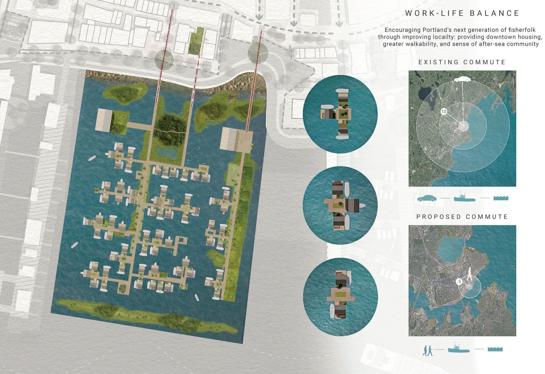

Top: Plan and Site Context
Bottom: Floor Plans of Lobstermans’ Floating House


Top: Aerial View of Floating Lobstermen Community
Bottom: Perspective of Floating Lobstermen Community and Lifestyle
The Future of Mobility Reimagining Portland Streets
Tianzhen(Tim) Jia
Rather than focusing on a single location in Portland, this design proposes a revolutionary street concept for the future of the city. With the increasing integration of autonomous vehicles into our daily lives, this design envisions a fundamental shift in the layout and function of streets. Street design will shift from being car-centric to human-centric, bringing numerous benefits such as improved connectivity and increased green spaces.
This design envisions various transformation strategies based on Portland’s different street types and widths. These include a Shared Public Way, which emphasizes widening sidewalks and creating more planting and cycling areas. Another aspect is the Industrial Corridor, which focuses on preserving Portland’s vital industrial transport hubs while simultaneously expanding public street zones. Additionally, the Transit Corridor aims to maximize commuting efficiency by creating dedicated spaces for pedestrians, ride-sharing services, and public transit, facilitating connections across the urban area.
As autonomous technology continues to advance, this design seeks to provide Portland’s future with improved transportation options and enhanced pedestrian comfort. Streets will be reimagined as vibrant public spaces, moving away from the binary separation of people and vehicles. Furthermore, as autonomous driving becomes advanced, vehicles will be able to operate continuously without human intervention. Large parking areas can be converted into parks or forests for public leisure. Altogether, these measures will enable the streets of Portland in the future to actively contribute to carbon storage and provide spaces for ecological restoration.


Top: The Transportation Plan of 2120
Bottom: Street Trees Design Strategies in 2120


Top: Birdeye Showing the Transition from Parking Lots to Parks
Bottom: Perspective of Congress St Transit Corridor


Top: Perpective of Middle St Industrial Corridor
Bottom: Perpective of Moulton St Shared Public Way
Floating Hub A Commercial District
Connecting Islanders, Portlanders, and Tourists
During a ferry ride on Casco Bay, I met an islander heading to Portland to get his dog groomed. Our conversation highlighted the challenges island communities face in accessing basic resources like fresh produce and healthcare. This inspired me to envision a floating commercial district that serves as a bridge between Portland and its island communities—a space that uplifts Portland’s blue economy, vibrant food culture, and abundant recreational opportunities.
Situated between an aquaculture hub and the cruise terminal, the district provides direct boat access for islanders, ensuring connectivity while welcoming tourists and residents to experience Portland’s dynamic culture. The district will be alive with activity, from people enjoying on-water dining t islanders arriving with their boats to access everyday services.
By 2120, the district’s construction will embody sustainability and circularity. Locally sourced black locust wood, saltwater-resistant geopolymer cement, and repurposed shipping containers will create a carbon-efficient, resilient foundation. These innovative materials demonstrate that reuse is the future—no new materials are needed.
Portland’s identity is interwoven into this district, but it’s not just for tourists or downtown residents. It prioritizes islanders, who often contribute equally in taxes but lack equitable access to infrastructure and services. As sea level rise threatens greater isolation, this district ensures fair access to essentials and creates a resilient, inclusive future for all. It’s a vision of connection, sustainability, and shared prosperity.


Top: Concept Diagram of the Floating Commercial District
Bottom: Plan of the Floating Commercial District


Top: Section shows the Life on the District
Bottom: Diagram of Local Materials and Circularity


Top: Birdeye of where Islanders, Portlanders, and Tourists Intersect
Bottom: Perpective of the Floating Commercial District
Co-Cropping Aquaculture
Portland’s Transformed Maritime Industry
Willa DeBoom
After speaking to Mainers last October, we heard how important a working waterfront–one that is reliant on local and intergenerational knowledge, occupational pride, and community cohesion–is to the cultural identity of the city. However, warming sea temperatures, species shifts, and aging infrastructure have left Portland’s maritime industry under threat from climate change.
To address the need for industry adaptation, this project proposes transitioning and expanding Portland’s water-based industry in the long term by establishing zones of near shore aquaculture.
Like agriculture on land, much of today’s aquaculture involves harvesting a monoculture of a single species, leaving farmers vulnerable to a risky financial burden in the case of a poor growing season. For Portland’s waterfront, the farming instead includes a co-culture of oysters, mussels, and sugar kelp. This will help to maintain the city’s distinct cultural character while also positively impacting the local economy, improving water quality, and contributing to a sustainable food system.
The diversity of use across the waterfront is a critical part of what makes Portland’s patina of culture so unique to the landscape. This proposal hopes to put fishermen first so those working along the waterfront can enjoy the collective atmosphere that Portland has to offer, helping locals and newcomers alike value who makes Portland, Portland.

Top: Concept Diagram of Future Co-Cropping Aquaculture


Top: Diagram of Circularity
Bottom: Diagram of Sequestration and Acidification


Top: Plan of Co-Cropping Aquaculture
Bottom: Perspective of Aquaculture

Top: Kelp Noodles with Marinated Tofu Recipe

Pamela Conrad
Pamela Conrad, PLA, ASLA, LEED AP, is the faculty lead and Design Critic at the Harvard Graduate School of Design. She is an internationally recognized landscape architect, 2023 Loeb Fellow at Harvard and Architecture 2030 Senior Fellow. With degrees in Plant Science and landscape architecture, she integrates nature-based solutions into the built environment, from large-scale habitat restoration to climate adaptation in San Francisco, California and beyond. As Founder of Climate Positive Design, Pamela’s work elevates landscape architecture’s role in addressing climate change. She serves as ASLA’s Climate Action Plan Chair and IFLA’s Climate Action Committee Vice-Chair. Recognized by Forbes and TIME for Kids, her accolades include the Metropolis Planet Positive Award and ASLA Honor Award.
Michael Blier
Michael Blier, FASLA, is a Lecturer in Landscape Architecture at the Harvard Graduate School of Design. He is a registered landscape architect and the founding principal of Landworks Studio, based in Salem, Massachusetts, with a satellite office in Taipei. His work focuses on urban, sitespecific designs that integrate ecological challenges, sustainability, material innovation, and programmatic needs, creating visually compelling and high-performing landscapes. Michael has taught studios and served as a critic at the Rhode Island School of Design since 1991 and has also taught at Harvard GSD and Cornell University. A sought-after lecturer, he has spoken at institutions including The Ohio State University, Penn State, and the University of Michigan, enriching the field of landscape architecture.
Teaching Assistant Shan He
Students
Qijia Chen, Garrett Craig-Lucas, Willa DeBoom, Shan He, Sakiko Isomichi, Tim Jia, Alexandra Kupi, Jein Park, Kati Wiese
Mid Review Critics
Curtis Bohlen, Sara Carr, Ryan Kanteres, Amy Magida, Milan Nevajda, Julia Tate, Heather Walters
Final Review Critics
Julia Czerniak, Matthew Cunningham, Kristin Frederickson, Matt Littell, Lauren Stimson
Lectures
Seth Goldstein, Ashley Krulik, Addy SmithReiman, Gretchen Schneider Rabinkin, Hannah Baranes, Curtis Bohlen, Matthew Littell, Natasha Kypfer, Alan Ricks, Kimberly Dowdell, Bryan C. Lee Jr., Kishore Varanasi, Alan Organschi, Timothy Lock, Tama Whiting
Envision Resilience Members
Wendy Schmidt, Claire Martin, Carolyn Cox, Cecil Barron Jensen, Charlotte Van Voorhis, Bob Miklos, Anjelica Gallegos, Anne Dougherty, Heather MacLeod
Collaborative Schools
Cornell University University at Buffalo New York University of Maine at Augusta University of Michigan University of Toronto University of Virginia
Yale University

Celebrating the Resilience and Sustainable Future of Portland and Final Studio Review Completion.
Photo by Anonymous


Envision Resilience: Imagining a Future Waterfront for Portland, Maine
Instructors
Pamela Conrad / Michael Blier
Report Design
Shan He
Report Editor
Shan He
Dean and Josep Lluís Sert Professor of Architecture
Sarah Whiting
Chair of the Department of Landscape Architecture
Gary R. Hilderbrand
Copyright © 2024 President and Fellows of Harvard College. All rights reserved. No part of this book may be reproduced in any form without prior written permission from the Harvard University Graduate School of Design.
Text and images © 2024 by their authors.
Image Credits
Page #46-50: Photographs by Shan He
Outside Cover: Photography by Garrett Craig-Lucas
Inside Cover: Photography by Shan He
The editors have attempted to acknowledge all sources of images used and apologize for any errors or omissions.
Acknowledgments:
We extend our heartfelt gratitude to everyone who contributed to the success of this studio, “Envisioning Resilience for Portland, Maine.” This transformative experience was made possible by the dedication, support, and collaboration of many individuals and organizations.
To our students—Qijia Chen, Garrett CraigLucas, Willa DeBoom, Shan He, Sakiko Isomichi, Tim Jia, Alexandra Kupi, Jein Park, and Kati Wiese—we thank you for your creativity, hard work, and vision in exploring resilient futures for Portland, Maine.
Our Teaching Assistant Shan He deserves special recognition for her tireless devotion and support. Shan was instrumental in organizing and coordinating the studio’s work and editing and publishing this report. Her contributions helped make this studio a success.
We extend a special thanks to Envision Resilience for their unwavering support and for serving as the cornerstone of this studio. As both a coordinator and a platform, they provided us with the incredible opportunity to delve deeply into the challenges and possibilities of designing for resilience in Portland, Maine.
Finally, we express our gratitude to the Gulf of Maine Research Institute for their generous support and for providing a venue for community engagement and our pop-up event. Their efforts enabled us to connect with the Portland community, listen to their voices, and collaboratively design a resilient future.
Harvard University Graduate School of Design 48 Quincy Street Cambridge, MA 02138
gsd.harvard.edu
This studio would not have been possible without the collective efforts of all involved. Thank you for your contributions, passion, and commitment to envisioning a more resilient future.
Studio Report
Fall 2024

Harvard GSD
Department of Landscape Architecture
Students
Qijia Chen,Garrett Craig-Lucas, Willa DeBoom, Shan He, Sakiko Isomichi, Tim Jia, Alexandra Kupi, Jein Park, Kati Wiese
