UNITED STRAITS

Supervisor: Erik G. L’Heureux


The search for a thesis begins with a probe into the subject - of coasts and of the region. Identifying quirks, anomalies, and trends. Uncovering operations and ambitions.
The built-up insertions along coastal frontiers can be generally categorised into the model as shown on the right. Dwelling and Industry form the two primary genres, their overlap producing a hybridity of complex and tenuous relations.


DWELLING consists a dynamic range of constructs from modern to vernacular, heavy to light. Gated communities privatising andfront village tenements composed of locally found timber and other scavenged materials assembled to form stilted surburbs.
INDUSTRY
cordoning off access and views from the public. Heavy industries ousted from the city centers to fringe peripheries mingle with ship yards and ports, planting roots at the edge by either relegation or necessity. Their structures telling of machinery and storage: frames and cranes alongside expansive warehouses.
Straddling the two ends where living space doubles as economic
CONSTRUCTS
Terraforming occurs at great cost along the coast in hopes of even greater returns. Forested mangroves and craggy isles make way for the clean splines of crisp edges and sinuous curves as arcoastal dwelling, the human take precedence, geography made subservient.
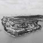
Leading the pack from as far back as the 1970s, Singapore’s world renowned reclamation endeavours brought forth Sentosa Cove and its contrived islands in an island of an island-state. The af-
lators and developers. With the spark ignited, it was only a matter of time before the neighbouring coasts of Johor and Batam caught up, today pushing out their own versions of mega-scaled soil and concrete sculptures at the seafront.
From the satellite’s view foreign formations have begun to mutate and modulate the once natural peripheries, the wild bushes of tropical forestry tamed for easy economy. Land terminates unnaturally and is barred from connecting with water by the man-made barriers of steel and concrete.

nally become useful. Dreams of wet licks from the tides at one’s doorstep now further segregate themselves from the have-nots. It’s a worthy cause for sure, aiding individuals and boosting national reputations.
The augmented coastlines typically bear home to landed properties and gated communities of high-rise and townhouse typologies inching as close the the edge as possible. Beaches are replaced with stilted decks and lengthy marinas; natural gradients with stiff perpendiculars masked over with stone tiling and cropped grass.

Developed toward economic ends, dwellers are generally not the cause of buildings but rather the targets who buy into the lifestyle.

PUTERI HARBOUR is part of the Iskandar Madevelopement of the state of Johor, Malaysia. Sited at the south-western tip of Johor, Puteri Harbour is IM positioned as the foremost and largest integrated urban development comprising access to the open sea,taurants and trendy entertainment outlets, and a promenade overlooking marinas and the Straits of Johor.
longing and ample space at Puteri Harbour along with


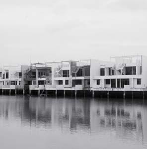
front land, this exciting and breathtaking waterfront development charts a new attitude to luxury living that desires whether of landed homes or high-rises.


part of luxury.
SENTOSA COVE spans the south-east edge of Singapore’s sub-island Sentosa. Progressing from the turn of the millennium, the development is brainchild of the Sentosa Development Corporation (SDC) and entails islands privately owned by the few whose prop-dise, Sandy, Pearl and Treasure Islands each strechting the outermost tip. Amenities and facilities are endless, with options for entertainment, dining, and yachting available within the cove and its surrounds. One can althe greater possibilities of Sentosa island itself.

A highly cosmopolitan community consisting residents waterfront living lifestyle. This is undoubtedly Asia’s favourite playground.
COASTARINA fronts Batam’s city center at the eastern edge of its middle northen fork. It is a prestig-



off the coastal edge coupled with numerous amenirecreational land and sea activies promptly available. of the world - The World, albeit in a more modest and understated manner. Oddly shaped irregularities form supposed continents in a roughly ellipitical overall montage slated for the building of semi-detatched houses and bungalows with waterfront access and living like no other.
house with a private driveway, mini-lawn, and land to call your own. That’s less than the cost of an aging cramped public apartment you have to tussle with others for in Singapore.
With low publicity levels and a empty website with little information, you can be sure there is room left for you at sunny Coastarina.
The world’s most desirable address. International lifestyle and entertainment city.
Luxury’s new attitude.
shoddy shacks on real coasts

At the other end of the economic spectrum, traditional villages of indigenous people groups have settled at the land edge. Sprawling assemblies of huts and shacks put together using locally sourced materials reach out into the water from within the land like a hand clawing its path to freedom. Bespoke pieces
Stretching into the boundless sea these shacks anchor roots into the coastal bedcal piles prop the structures off the actual ground, minimising environmental impact from built forms. The fringe remains gradated, seeping slowly from land to sea as per its natural state.

to purchase a unit for cheap or as a novel artefact of heritage. Clean water and electricity is not guaranteed.
Return to rural beginnings, to a time before modernity where homes were built by hand and owners are both constructor and occupant. The nostalgia of traditional coast-life awaits.
Most work is found inland and housing is less problematic. As such, people have few reasons to cling on to their stilted villages at the sprawling coastline far removed from the city center.
Of the three states for coastal consideration, Singapore, the leader of the pack in developmental terms has successfully eradicated all traces of traditional seaof them. And while we’re on that topic - real coast has also been altogether supplanted by interventions for security and safety. Singapore fails to make this list, a remarkable feat considering its penchant for topping charts.

Batam tops the list with the most number of coastal kampungs all of relatively who refuse relocation to the few public housing options available and their sorely lacking infrastructural support. Sparse incomes leave little options and workplace proximity serves to increase the intangible valuation of these homes. For most, home remains where the shack is.


CONSTRUCTS
TANJUNG UMA lies at the center of the Ampar Port. It is considered the oldest indigenous community by the municipal authorities Batam’s industrialisation, it’s formation began


Today tourists can be found seeking out Tan-ditional Batam lifestyle and to soak in the rich local culture. Fishermen double as water-taxi drivers as well, ferrying tourists out into open waters for the panoramic view of the waterfront village sure to entice avid photographers and sight-seeing buffs alike.
KAMPUNG JAWA sits at the south-western tip of the Johor coastline, facing the Singapore the coast serves the small community largely
to further off parts of the territory when necessary.

front the homes from which they set out each day to seek new harvests for the perpetuation of their simple and laid back lives. Organisation and hygiene here is much improved over their to as a slum.
realisation as upgraded imitations dotting the beaches that form the coast. Spartan units of roof and frame fabrications provide temporary shelter and respite for tired beach-goers.
These huts vary in expression according to their regions: concrete and tiled templates repeated along Singapore’s East Coast Park and diverse selections of stick, tarp, and cardboard Pinggir.


 bare huts on beach fronts
East Coast Park, Singapore
hulking metal constructs are demonstrations of epic engineering and the marvel of modern technology. Their assembly begins on land and gradually moves into the waters, cubic masses drifting out like shopping malls being reclaimed for Atlantis. Metal balloons of disproportionate scale give bouyrobotics, standing tall in frigid waters.
CONSTRUCTS

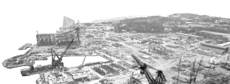
Ships of varying classes line up shoulder to shoulder at the docks, their with framed grids of mul-ties as their await a new lease of life. Ship surgery promises decommissioned and dated vessels a second tankers rebirthed as Floating Production Storage and Floating Storage and impending decline as the global economy slumps. Commissioned vessels by large corporate maritime players are spawned in the same nurseries as their cousins the rigs. The canal of their birthing takes place at elongated drydocks, rectangular masses latticework carved away to reveal the glorious 000 ton monsters, the berths are capable of them all.
Maritime construction is big money in the region known for its ports. All manners of vessels and marine beasts are welded together at the docks and yards slumped at coastal domains like blight eschewing nature. The monotony of raw earth or graded concrete wash these extensive areas and obstruct all forms of organic life save for that of its creators.
Interspersed with the trading terminals of the Singapore port are the Jurong Shipyard under the umbrealla of Sembcorp Marine and the Keppel


ence, from simple vessel repair and maintenance to ship conversions, and the manufacturing of massive vessels of various classes and behemoth offshore rig varieties.


panies heavily invested there along with an array of local companies. The barren lands here are swathed in hues of red and orange - the convergence of rust, copper, and the trademark red Batam earth.
Where the organic ceases, new life emerges: the industrial forest takes root.
SINGAPORE‘s port ranks as the second busiof close to 30 million annually. Strategically positioned at the strait connecting the East and West, this geographical advantage has been leveraged since colonial times establishing Singapore as the entrepot trade hub of the region.
south-western coast, the port is managed by Portdiction of the Maritime and Port Authority. The GDP. The largest terminal - Tuas - is slated for completion in the near future.

JOHOR hosts two ports along its extensive south-
ated at the western end sits at the mouth of the Pulai River and since its opening in 1999 has seen steady growth, setting a world record for handling a choice alternative to Singapore’s Port, it has successfully wooed Maersk Sealand into being a stakeholder and shifting its operations from Singapore,
Centrally located near the Woodlands causeway, the Johor Port serves the Pasir Gudang industrial town specialising in transportation and logistics, shipbuilding, petrochemicals and other heavy industries, and oil palm storage and distribution.
BATAM boasts only one shipping port of Batu Ampar close to its northern tip. The port is rela-
and meet its demands.
There is a high demand for the extension and added development of the Batu Ampar port to accommodate the rising volume of cargo and containers in line with the growth of foreign inplants dot the island with more expected sprout, and their goods are eager to be exported.
The typical shipping terminal hosts an amalgamate of serveral construction variants. Stiff linearities at perpendicular angles shape the coastline with rectangular cutouts stamped into them. Tetris fantasies

of stacked modular containers piled one on top of another, a rainbow of colours spread over a pixellated landscape.
Mammoth cranes and frames loom over the crated terrain like AT-ATs in a defensible formation, the guardians at the borders. They work together to continually reshape and trade the inventory for new pieces, meadows. Here, coast meets machine in


terminals of the Singapore port handling -

Berths, Max Draft, and Area.

CONSTRUCTS
The coast as an optical construct prioritses the optical over every other factor. Planning and architecture is centered upon the attainment of the view, the blue gold picturesque beyond the window’s frame. The coast within this paradigm is something to be looked at but not touched, a prized painting of serene nature that sup-

times the eye has been championed as a superior tool for sensing, and coast here is made compliant to feed its appetite.

all know the tedium of building on undulating ground and the myriad of challenges it poses; a rebirthed nation needs a clean slate for physical construction.

beauty was not so easily defeated. The hills found reincarnation upside down, tipped over to form new land stretched outwards.
Mountain and water persists. Idealised beauty made abstract, made pragmatic.
Places of dwelling and their increasing opulence inch ever closer toward the we ought be weary of. experience recreated at risk-free premiums.


Security is paramount when coastal regions are constructed as defensible spaces. Coast here is elevated to a status of inaccessible, with prevention and repulsion the key aims of its architecture. Fences, barriers, and outpost ring the island’s perimeter, strategically positioned out of sight to maintain the appearance of tranquility. Beneath, an ongoing struggle against illegal immigration and terrorist escapes wages, with matters of national security at stake. Access to these areas are denied or at


acess and controlling egress. Coast must be protected, for it is the gateway to the city.
As sovereign territory, Singapore must defend its shores against unwanted and
nant persons are sieved and repelled by the coastal interventions that line the Singaporean shore. The northern fringe where illegal crossings have proven to be most popularly attempted is home to kilometers of resistance architecture. The fortress is protected against man and tide, or at least that is the intention. These often hideous intrusions at natural boundaries are hardly maintained and gaps can easily be found. Damages and malfunctions are commonplace. Their keep the terror away?

Nonetheless, some defense is better than no defense; better safe than sorry. Ugly is a small price to pay for a sense of security and going to bed each night without fear of an enemy beach landing.
-is watching you. Like periscopes sticking out beyond the water’s surface, watchful towers police the borderlines. The coast is constantly watched. Covertvironment. Checkpoints and causeways are overlooked by ominous structures looming overhead.


Here buffered on all sides by other coastal wrappers it is able to access both of vantage, but you cannot see it. And by the time you do, it would be too late.
An architecture of surveillance is all around, watching unannounced. It is the silent guardian of sovereignity, the stalker by the window pane. Strategic posi-

CONSTRUCTS
Kick back and relax at the coast, a place for leisure. Romanticising the fringe as sandy beaches and riverside piers, a place of refuge and restoration, a place of rest and recreation. This construct actualises the coast into desirable nature crafted by human hands, working urban architecture into ‘natural’ landscapes to synthesise harmonious places for park activities and a union with nature.
The island’s natural edge is removed and replaced for the provision of a rustic, relaxed amenity for public enjoyment. Swampy mangroves and mangled roots housing all manners of wildlife is a cumbersome thing to experience. One has the skin. Few can appreciate such nature.
Coast should be a place of delight: jetties, boardwalks, and tranquil scenes. Imagine the cool breeze brushing past you as you stroll along serene still waters under the shade of tree canopies. Landing a catch at the jetty that projects into open waters. Boardwalk strolls barely above the sea line, the wet licks of waterinches from your feet. The parks care about nature, just not the old one.
Leisure and settings at the park idealised and romanticised. Re-creating nature


a handful of trees to serve as patchy cover-ups. Narrow and insular constructions of coast have led to hard boundaries between zones and the uneasy coexistence they lead side by side evokes awkward discomfort to the discerning and enlightened. Pollution and parks don’t really mix well.
inconsequential. It cannot be helped, space is tight. Is there really no better way to do coast?
Divides have to be better mitigated and architectures better syncretised. The reconciliation of various coastal constructs remains unanswered, tied down by modern planning.


 cheekiiemonkie.net Wikipedia
Google Maps

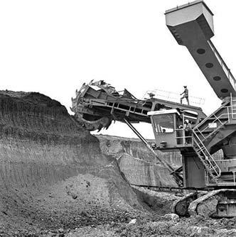
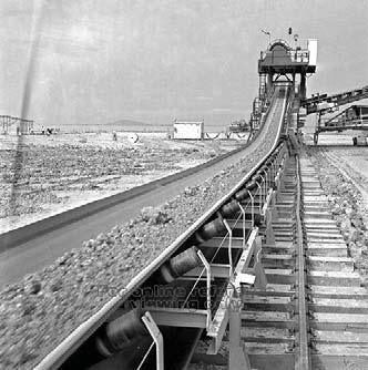


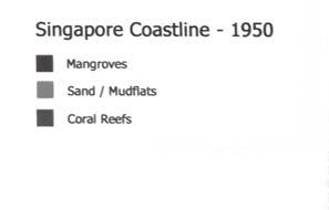


II.
EXODUS
The search narrows, a condition in close inspection. Departure from the broad sweep. Entering a new promise.
Source(s):
Comprehensive Development Plan for South Johor Economic Region 2006-2025.
Malaysia: IRDA, 2006.
Chia, Lin Sien, Habibullah Khan, and Chou Loke Ming. The Coastal Envi-
Legend
Coastal Regions
Source(s): Chia, Lin Sien, Habibullah Khan, and Chou Loke Ming. The Coastal Envi-
Legend
Source(s):
Author’s own mapping off Google Maps, cross-referenced with Comprehensive Development Plan for South Johor Economic Region 2006-2025. Malaysia: IRDA, 2006.
Source(s):
Comprehensive Development Plan for South Johor Economic Region 2006-2025.
Malaysia: IRDA, 2006.
Legend
Source(s): Legend
been relegated and that the gradient of transi tion whether hard or soft has been lost in fa


Source(s): Shahrizaila bin Abdullah and Hiew Kim Loi. Coastal Reclamation in Ma-
II.5
TRANSIT
Conceiving compressions.
A compressed condition at the coastal edge informs of a larger operation. As lands inch closer together a damaged strait is narrowed.
How can the strait reprise itself in tandem with the ambitions that seek to diminish it? How can it become more than the no-man’s land.
COAST.
moment.
expanses of water bodies fringing territorial boundaries, here we prefer to return to its intended origination-
aries of landward or seaward limits unrestrained as long
land and sea, and neither land nor sea - a paradox of extremes. Its ambiguity and ephemeral form make it a
lose bearing.
AIM & SCOPE.
Coastal developments are not new to the region. Early-


tion between land and sea. Beholden to developmental monetisation on land and hard engineering solutions,-
sea, the edge tending towards being a buffered zone of loose programming as in a park or promenade. Rather than melding the two elements, these zones end up be-
urban edge and move against the normative hard-liningwall and the barrier zone.
 ChangiPasir RisEast Coast
Harbour FrontPulau UbinDanga Bay
PunggolWoodlandsLabrador

opmental pressures pushing land outwards and the urban has been planned, with aims to establish an upmarket wa-
tory of value.
erage upon.
the land and rests on tubular piles, hiding a narrow strip of
an expanding sprawl.
PROJECTIONS.
More resolution lies ahead.

III.
ARRIVAL
A project found towards a purpose. Architecture meets national agendas. Infrastructures making place.
A figural park that straddles the Johor Strait.
It is a territorial monument unto a newly unified Singapore-Iskandar region.
This arises out of a collective impetus led by
1. an impending water shortage faced by both growing states
2. a heavily polluted strait as is presently existing
3. the land expansion ambitions of both states narrowing the straits
The Johor Strait is re-conceptualised not as a dividing line of tension but rather a unifying territory and a liquid asset. Its fingers reach into both sides and bind them as one. It shifts from being a barrier to glue.
A series of barrages are implemented at strategic points along the western Strait. These double up as four additional crossings put in place between the current Tuas and Woodlands causeways. Key economic activities and ecosystems such as the Pasir Gudang Port and Pulai/Johor Rivers are left relatively uninterrupted.
Some livelihoods and natural habitats will become unintended casualties in the name of national progress and survival.
The new infrastructure will serve as devices for the remediation of a damaged water body into freshwater reservoirs and enable increased physical connectivity between the two rejoined states - a singular thriving hub of ISK-SIN kept fueled by an ample water resource.
In the near future of this reunion a borderless zone is anticipated where movement and use is fluid and free. The physical devices for control and denial become redundant as state surveillance and tracking becomes normalised. Defensive coastal structures are removed to make way for an open future.
At the center of this newly established field a figural rectangle is imposed. It measures 4km x 1.6km - the equivalent of two Central Parks. This is the formalising of both state’s commitment to unity - a recognition n of common ground. This ground encourages and allows for fluid spatial freedoms where Iskandar, Strait, and Singapore are experienced and encountered as a singular place. A void strip 50m wide is carved along the length of the zone to differentiate it from its surrounds. Infrastructural conduits in parallel flank the other two sides of the rectangle and act as monumental gateways into the area; transcending their generic roles by becoming the cornerstones of place making.
The figure comprises sub-figures: programmatic bubbles that traverse the waters. Recreational, militarized, and circulatory areas are made identifiable and interactive. The training areas of Singapore extend across to form a joint training zone just as the palm machines of Johor’s economy are made exposed. Existing scatters of urbanism from both sides become participatory in the recreational zone.
These are held together by the primary program of a park that spans across the figure. The park is a place for leisure and the public display of a homogenised community. Through the control and alteration of planting and terrain it distinguishes itself from the sub-figures. Positioned at a typically higher elevation, it dips into the sparsely vegetated sub-figural bubbles before upturning into shaded reprieve.
In this site differentiation dissolves and trust is built. Its maintenance and continued use stands as testament to a growing relationship of unity. In time to come, the rapid unrolling of urban waterfront developments may come to dominate this linear territory; the established park will persist - an oasis amidst concrete jungles.
Singapore and Iskandar in dire straits.
Iskandar reports an impending water shortage from 2025, inadequate to support its expanding population growth even with the addition of new water treatment plants.
Singapore looks to yet unrealised research for increased efficiency and production of its desalination and NEWater attempts. A promise in a fragile bubble once its water dealings with Johor ceases in 2061.
Opportunity. The straits transforms into a potential resource, an exploitable asset to be shared. Both states must agree and move into a new union - an equitable union compelled by common needs and a grasp for survival.
Coupled with the propellants of a heavily polluted strait in need of remediation and the apparoching terra-centric ambitions of both states, a grand unification project is presented and made ready for implementation.
A series of four new barrages are installed across the narrow strait between the two existing causeways. Strategically positioned as critical paths connecting to the upcoming urban districts of Medini, Puteri, and Danga Bay.
A union of possibility by land and by water.
Imagining a landed union, when both nations reject the strait’s existence and reclamation dreams collide.
A new figure is formed, a singular mass.
A singular thriving hub. Highly connected, highly supported. City cores of Singapore and Iskandar merge via an extensive network of surface and sub-terranean links. Access from one to another is direct and convenient, served by adequate and expansive infrastructures of road and rail alike.
At the center of all this lies the strait as an emerging third space, the binder of once divided soverignities. A softer union can be read as having always been present - the geographical basin formation that feeds into the strait.

Hard structures of control and denial become redundant in light of the newly established common territory. Defensive structures can begin to be removed to make way for an open and shared future. Access, movement, and use increasingly become fluid and free.
With the rise of technology, the citizentry consensually relinquishes certain personal privacies for greater spatial freedom. State tracking and surveillance becomes the accepted norm.

Sharing is an old tradition of both states. Since their coming of age more than half a century ago, a history of territorial trades and swaps have taken place. A mark of friendly ties and mutually beneficial leveraging.
From reservoirs and railways to more recent economic developments.
The new deal takes this further, as distinction and separation is further dissolved and two states become one.

A new figure imposes itself at the center of the liquid third space. A formalised agreement manifested on common ground.


Iskandar, Strait, and Singapore meld into a single entitiy - experienced and encountered as one. THE FIELD represents this new reading, with edges indistinct and areas overlapping. Same but different.
It is here THE FIGURE cuts, its boundaries demarcated by void corridors both carved and sculpted. A new common park is established, crossed with sub-figural programmatic zones that traverse the waters.
A triptych of perspectives of the realised park. Intersecting and interacting programmatic zones, entry and access. An architecture of planting and terrain shapes and configures the spaces experienced within the park. Engineeral infrastructure steps up, supporting the built gateways into the figure.


IV.
REMNANTS
Those that fell by the wayside. Little alternatives and catalogued struggles.
In-betweens now left for last.

 A three-figured attempt.
Two urban figures and one pastoral figure. Linear connections utilised as soilid and void respectively. A table to hold urban infills and an empty gateway to herald entry.
Figure 1 the park still being grappled with. Figure 2 the urban periphery leveraging on existing built-up townships of JBCC and Woodlands. Figure 3 the industrial ring for minor goods and importation in close proximity to PTP and Tuas Port.

