2020
april - july Greater Bay Area, China
Globalisation studio
Resilient city networks
Divya Gunnam Kinga Murawska Zhongjing Zhang
Delft University of Technology
Sanjana Shettigar
The Hong Kong Polytechnic University
in collaboration with
Delft University of Technology Department of Urbanism in collaboration with The Hong Kong Polytechnic University Quarter 4 | April - July 2020 Research and Design Studio Globalisation Studio mentors: TU Delft Diego Sepulveda Luisa Maria Calabrese Daniele Cannatella PolyU Gerhard Bruyns Peter Hasdell
Abstract
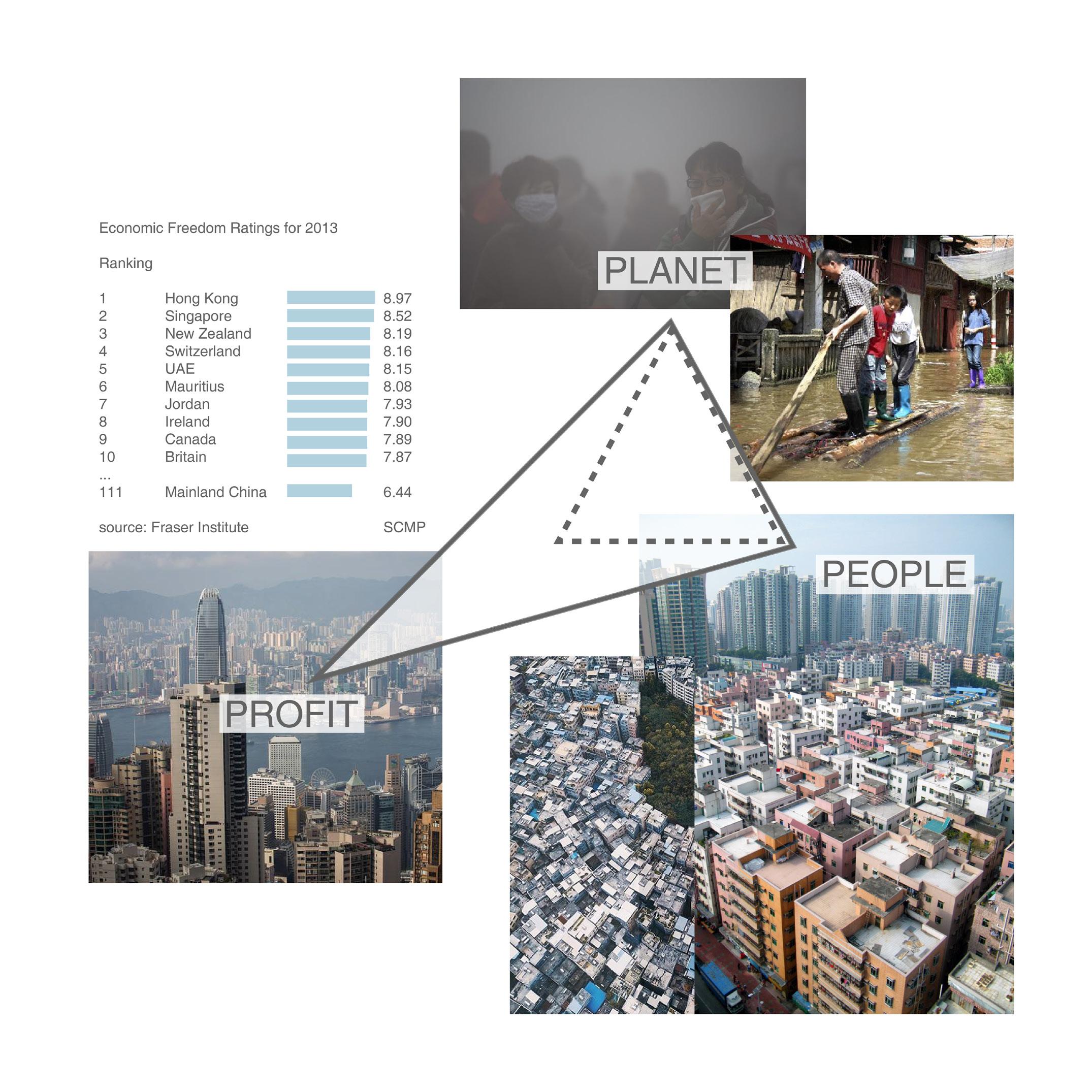
The Greater Bay area is a vital economic player both nationally and internationally with several ports, innovation hubs and manufacturing industries. Through economic revolution over the past five decades, the area developed profitable industrial landscapes that provided principal contributions to the growth of the region. These developments have also influenced how four territories i.e. fire (economy), air, earth and water have been inhabited. The territory of the economy is also mainly responsible for the transformation of other territories. This profit-oriented character of the economy, however, no longer fits well with the changing societal values as the current pattern is highly detrimental to the ecological systems and contributes to unfair human inhabitations. Market liberalisation, lack of government interventions have resulted in the division of class systems with high-income disparities and lack of fair access to the territories.
A gap between the environmental protection organisations and the spatial planning disciplines have led to ecological criticalities like frequent flooding, drought and other catastrophes. The current model, if continued, would contribute to environmental destruction and ignore the values of a well-functioning society which places a strong emphasis on a fair, healthy, diverse and inclusive approach towards future developments. To transform this profit-motivated growth and guide towards a people-ecological centric equilibrium, the project propagates resilience thinking. The vision addresses the existing shortcomings while also creating a robust environment in the future that can withstand any externalities. The project aims to achieve evolutionary resilience within the region which emphasizes the radical changes of social-ecological systems over time and places importance on persistence, change and unpredictability.
These interventions are strategized from the perspectives of four territories. A transition towards a knowledge-based economy making it the new centrality addresses socio-spatial justice and explores the spatial implications on the morphology of the region. The vision stresses the need to bring people forward and transform them from passive actors to active agents of change. The region would become a synergetic and resilient urban network where local potentialities would be identified and upscaled by innovations. The people will remain the main drivers of change which aims not only at mitigating the effects of previous destructions but also reverse them by integrating green and blue multifunctional landscapes with human systems. Keywords: Evolutionary resilience, Territories of inhabitation, Societal Values, Spatial justice, Agents of change.
Table of contents
Introduction Introduction Evolution of the region Methodology framework
8 10 12
Theoretical underpinning Conceptual framework Research question Theoretical underpinning
16 24 25
Analytical framework Fire National and global importance Migration Economy Future growth patterns One country, two systems Earth Land use Agricultural land and urban villages Three olds Water Inhabitation of water territory Environmental risks
28 30 32 34 36 38 40 42 44 46
Vulnerable edges Air Air quality Poor living conditions
48
Problem statement
54
50 52
Strategic framework SWOT analysis and matrix Values Vision statement Morphological game Building strategies with lines Connecting green structures Developing three networks Nansha - Dogguan Zhuhai - Zhongshan Shenzhen - Hong Kong Resilient thinking through linear systems Game conclusions Manifesto Manifesto
58 60 62
66 68 70 72 74 76 78
Strategies Meso scale Micro scale People as agents of change Rural area Character and challenges Strategies Meso scale Micro scale People as agents of change
112 114 116 118 120 122 124 126 128 130
Planning framework Planning framework and actors Phasing
134 136
Final vision - GBA beyond 2030 The vision
140
Evaluations Space Syntax evaluation
144
Conclusions Conclusion Group reflection
148 149
80
84
Evolutionary framework for change Multiscalar approach Principles and strategies Mega scale Macro scale - Central heart - Nansha
88 90 92 94
Urban area Character and challenges Strategies Meso scale Micro scale People as agents of change
96 98 100 102 104 106
Peri-urban area Character and challenges
108 110
Relevance 150 Limitations and Recommendations 151 References Data sources Literature references
154 155
Introduction
Introduction Greater Bay Area as an economy-driven fragile system of territories
The Greater Bay Area is a megalopolis located in the south of China. Also known as the Greater Pearl River Delta, it consists of nine cities and two special administrative regions. With a population of over 71 million, and with a GDP of USD 1,642.5 billion, the Greater Bay Area has the highest recorded rates of urbanization and economic developments in the world. Nested in an intricate yet fragile delta system, the region is very prosperous with myriad landscapes like industrial areas, urban and rural centres, natural reserves and agricultural lands. The territory also has dominant aquaculture like fish ponds which is closely connected to its heritage. However, this close dependency that once existed between the people and the natural systems is lost since the onset of industrialisation. With the open-door policy of 1978 (Xiaobin, 2004), the region underwent a swift economic restructuring, transforming from the agricultural sector to the manufacturing sector.
8
While these transformations led to high levels of employment and growth of urban centres, they have also contributed to high levels of migration, loss of biodiversity like the disappearance of mangrove forests and exposed millions of people to environmental hazards (Zhijia, 2015). The current development model based on efficiency and high profits is detrimental to people and the environment. The inequalities in the region express themselves in stresses, unhealthy lifestyles and unjust claims over natural systems and territories (Lankao, 2011). These contribute to the growing environmental criticalities and social-economic vulnerabilities. The Greater Bay Area is now envisioned as an innovation and technology hub of the future; facilitating economic progress. This development must happen in accordance to the values and principles that pertain to a well-functioning society. It is vital to address
the existing challenges while also building up the evolutionary resilience of the region. As a world leader in the global economy, the region should become an example of how to reverse those negative effects and proceed responsibly in the future. A vision and strategy are developed in the scope of this project to shape this transition. It envisions a drive engine that focuses on building the socio-ecological and socio-economic resilience of the region. Resilient thinking would understand the complexities of human and natural systems and tackle the eccentricities that are unique to the area. The vision aims to develop a value-based developmental model that is mindful of people and their quality of life. The resilient city network model would achieve dynamic equilibrium contributing to a fair and equitable society, mindful usage of resources and overall sustainable development.
9
Evolution of the region How did the region transform over time? What caused the changes? How did it influence different territories of the area?
The Greater Bay Area is one of the most economically dynamic and densely organised agglomerations of the world. The region lies in the low-lying land of the Pearl River estuary. The strategic position on the South China Sea has opened up many opportunities for the transformation of its economy. Historically, a grain-producing region of China, agriculture and aquaculture were the dominant land uses of the area. Since 1987, with the national reform implementation and the open door policy leading to market liberalisation, the region experienced prosperous economic growth. It started with rapid industrialisation that then set off major urbanisation patterns which transformed the character of the whole area. Rural areas transformed into non-agricultural economies which changed the land use and subsequent productive capacity of the land. New ports established across the major coasts of Shenzhen and Hong Kong areas opened up the economy
10
to the world while creating a robust national infrastructure system. This rapid economic and population growth caused tremendous changes in the land use patterns, water systems, air quality and societal structures. It witnessed a dramatic expansion of built-up areas making the construction sector the main form of land use. Rural areas transformed from the agricultural sector to non-agricultural economies like the manufacturing sector. These transformations led to vast migration patterns with large floating populations. Large cities expanded rapidly and villages quickly transformed into towns and cities. It also led to the creation of urban villages which were encroached by the expansion of the urban centres. Another impact of this development is the land reclamation towards the sea and rural urbanisation. The coastal fishponds and the seashores transformed into built-up
areas and led to the shrinkage of mangrove ranges (Gao et al., 2010). It also led to the saltwater encroachment resulting in a decline in the wetland areas and water supply shortage. With the onset of climate change and rising sea levels, this area is particularly vulnerable to flooding and exposes many vulnerable communities to these environmental criticalities. Finally, the area is at the brink of undergoing another transition to a service-based innovation and knowledge hub that would result in new infrastructure structures and changes in the area. With new ports established and industrial sectors transforming, the old industrial lands, old villages and ports in the old city centres have to face new functional transitions, determining a new agenda for a sustainable regional transformation that is reflective of the values to cope with the unpredictabilities of the future.
11
Assignment
Methodology framework
Evaluation a
Assignment What is the assignment? A strategy for the region of GBA, with a focus on socio-economic and socio-environmental systems and the metropolitan model. Consideration of socio-spatial justice and integration of built and natural systems.
What is the scientific and soc What are the ethical and democ What is the gap and what is rec
Ethical, societal and scientific reflect
Background Research What are the main prevalent structures in GBA? What are the topics of Interest? Polycentric Model & Urban Fragmentation; Assessing Environmental conditions and Risk Poverty and Targeting: Incidence and Policy Implications groups; Planning perspectives Desk Research: Study and analyse the area, the stakeholders and the GBA vision 2040 Methods: Literature research, lectures, documentary and news
Context Analysis Spatial Analysis
What are the morphological structures prevalent in Greater Bay Area?
Challenges What are the main challenges? Growing inequalities and income disparities Lack of fair access to four territories Socio-economic vulnerabilities Socio-ecological criticalities Methods: Literature research, Context Analysis
Conceptual Framew
Historic Analysis
What theories are used to answe What are the different systems e
Economic Analysis
Evolutionary Resilience
How did the region transform over the past century? How did the economy contribute to the evolution of the region of GBA? Ecological Analysis
How does the current growth model exacerbate ecological adversities? Territorial Analysis
What are the impacts of the economy on the other territories of inhabitation?
Humans from pa
Relationships an Knowledge as a
Environmental impact Analysis
What are the environmental consequences of the current developmental model? Societal Analysis
What are the current societal problems? What should the new values be in the area?
12
People
Pla
Method
Vision
Strategies
What is the future of the GBA’s growth and how should it look like? Values
How to shape the transition from profit-motivation towards a resilient thinking growth model? Guiding principles
• People as active agents • Resilient thinking
Derived from Context Analysis
Territorial Analysis
Derived from values
Interdependencies of systems
Stakeholders and new initiatives
Vision Building Local Potentials
Spatial & organisational interventions
Visualisations Impressions
Operability
Methods: Values, concept building, ideal scenario, literature research, research by design, visualizing (collage)
Multi-scalar approach of phasing and policy changes
Methods: Guiding principles, stakeholder analysis, morphological analysis, mapping, research by design, visualizing
and Reflection
Tools
cietal relevance of the project? cratic implications of the project? commended in further research?
What are the different tools used in strategising the principles? What are the assessment frameworks to evaluate the new interventions?
tions, conclusion & recommendations
Morphological Game
Space Syntax
Resilient thinking
Infrastructure Analysis
Linear systems
Values
Lines as tools
Axes, Edges and Networks
What are the essential values?
Values as guiding principles
Climate Adaptation Biodiversity Conservation Healthy Cities Well-being of People Socio-spatial Justice Knowledge Economy
Strategy building
Potential Interventions
Multiple Iterations Vision Building
Maps and models
Bio physical Allignments Expansion Strategies
Spatial Interventions Maps
Methods: Mapping, model making, sketching, software support
Research Question
work
How can value-based integrated planning redirect the course of development in the Greater Bay Area towards a people-ecological centric equilibrium?
er the research question? explored?
assive actors to active agents of change
Spatial Justice
nd complexities between the four territories
Territorial thinking
public good
anet
Derived from strategies
Problem Statement
Fair access
Prosperity
Place
ds: Literature research, Context Analysis, Concept building
Purpose
A profit driven developmental model at the expense of people (Social vulnerabilities) and the planet (Environmental criticalities) resulted in unsustainable growth.
13
Theoretical underpinning
Conceptual framework Which theories form the basis of our concept? Which theories were used to answer the research question?
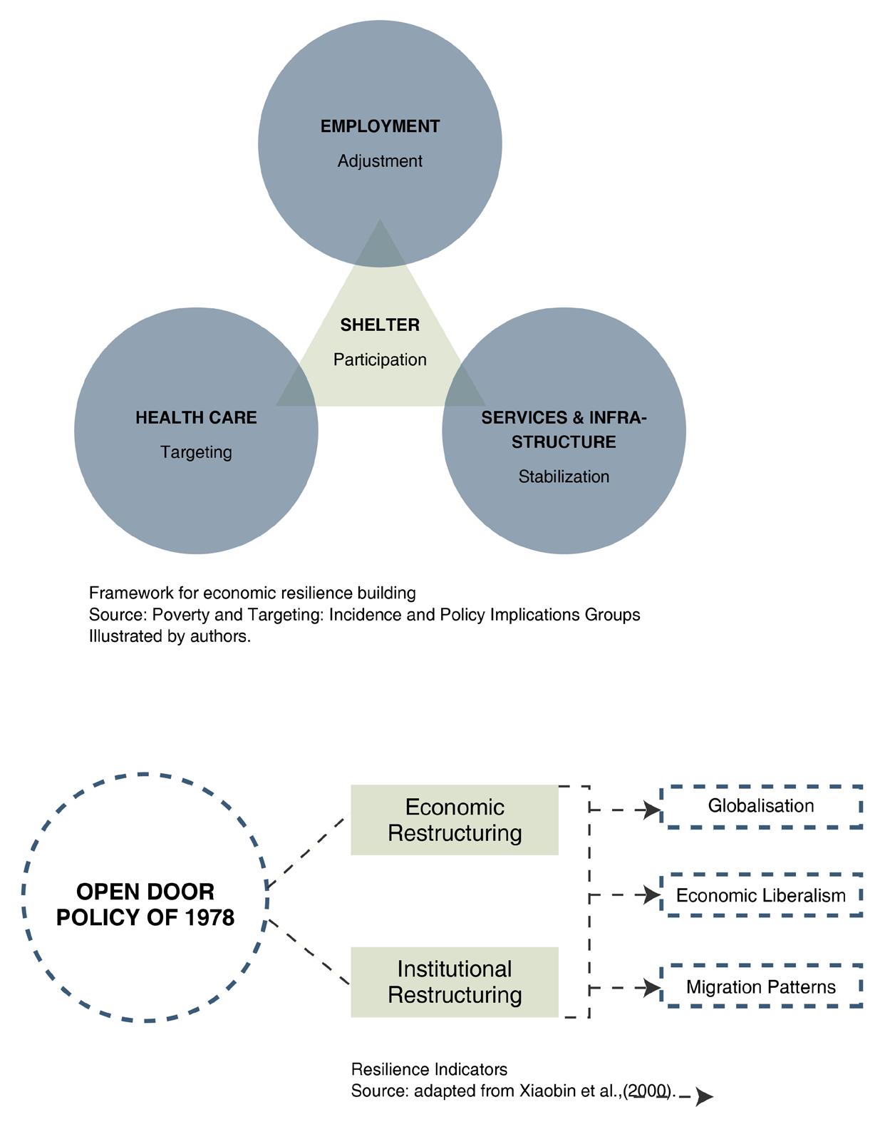
With the open-door policy of 1978 (Xiaobin, 2004), the region of Greater Bay Area underwent a swift economic restructuring, transforming from the agricultural sector to industrial, manufacturing and service-based economies subsequently. Through our research, we identified patterns of negative consequences caused by this economic drive in the region. The current development model based on efficiency and high profits is detrimental to people and the environment. The project’s goal is to shape the transition from a profit-driven economy to a people-ecologic centric growth. It also addresses the demands on urban cores and the plethora of vulnerabilities that are plaguing GBA. A body of literature was studied to understand the region and resolve these challenges. This chapter explains the conceptual foundation of this transition. The foundation is mainly based on the following theories. Resilient thinking, Territories of inhabitation, Transitioning people from 16
passive actors to active agents of change, Knowledge distribution. RESILIENCE BUILDING While the market liberalisation in GBA led to high levels of employment and growth of urban centres, they have also contributed to negative consequences on the ecological systems like high levels of migration, loss of biodiversity, the disappearance of mangrove forests, water scarcity, air pollution and exposed millions of people to environmental hazards (Zhijia, 2015) (Chan et al., 2013). The inequalities in the region express themselves in stresses, unhealthy lifestyles and unjust claims over natural systems and territories (Lankao, 2011). These contribute to the growing environmental criticalities and social-economic vulnerabilities. Vulnerability is the exposure of groups of people, individuals or systems to external or internal stresses. (Adger, 2000). Social
vulnerability generally means disruption to livelihoods and loss of security. Stresses could be defined in both social and ecological terms. Social stresses could mean a lack of income and resources, civil strife, impending war and other factors (Chambers, 1989). Ecological stresses could mean potentially irreversible changes to the environment that might create an impact on human life that is dependent on it like flooding, heat strokes, droughts etc. Resilience increases the capacity to cope with stress and can be. considered a solution to deal with vulnerability. Building resilience needs to be an integral component of climate adaptation, environmental management, regional economic development and strategic planning of the Greater Bay area to address the prevalent challenges. Resilience is broadly described as the capacity to bounce back (Davoudi, 2012). There are three broad classifications of this which are constantly overlapping: social, economic and
ecological resilience. Social resilience can be defined as the ability of groups or communities to cope with external stresses and disturbances (Adger, 2000). These external factors could be social, political or environmental. Stresses can be characterised as disruptions towards communities, livelihoods and forced adaptation to the uncertain physical environments. In the region of GBA, the pervasive nature of growth often causes stresses that are related to economic and social situations like lack of income, poor health services, accessibility of natural resources (Chambers, 1989). Human and ecological systems are interdependent, their resiliences are linked through the dependence of communities and their economic activities on ecosystems. The degree of these dependencies is uncertain and understood through historical, cultural and socio-political factors. In the region of GBA, the agrarian communities started giving up their land for the process of development. The new hard engineering strategies that came into place disrupted the natural balance of the region exposing these communities to greater threats of flooding. Ecological resilience is buffer capacity or the ability of a system to absorb perturbations, or the magnitude of disturbance that can be absorbed before a system changes its structure by changing the variables and processes that control behaviour (Holling et al., 1995). The human intervention on ecosystems has historically suggested the inevitable decline in its resilience with technological lock-in and reductions in diversity (Holling & Sanderson, 1996). 17
The concept of resilience depends on other configurations of human-ecological dependencies which can have explicit spatial dimensions to this process (Adger,2000). These concepts; environmental criticalities and social vulnerabilities are distinct in how they can be used to define the state of certain complex systems. On an ecological front, the region is on the verge of reaching a critical condition where potentially irreversible changes may be experienced. The social vulnerability to this economic and environmental change should be studied or observed in relation to human-induced risks or natural hazards (Klein et al., 1998).
The growth phase (r), conservation phase (k), creative destruction phase (Ω) and reorganisation phase (α). This kind of resilience thinking doesn’t allow for human interventions to break the cycles of persistence, adaptability and transformability across multiple scales and time frames in ecological (natural) systems (Davoudi, 2012a drawing on: Holling & Gunderson, 2002; Walker et al., 2004; Folke et al., 2010; see also, Galderisi et al., 2010; Miller et al., 2010). The changes in resilience will be anticipated and be dealt with through systems design and management.
Resilience thinking includes studying the functioning of the system and not just the stability of its components (Pimm, 1984; Holling et al., 1995). It is also imperative to develop resilience to disturbances than resistance. To observe social resilience, we have to consider economic factors, institutions in power and demographic change. Diversifying resource dependencies of communities enhances resilience through stability and functioning and this is key to biodiversity conservation.
Cities are living organisms that are vulnerable to change; resilience should be understood not as a static presence but a process to withstand these nonlinear unpredictable dynamics and patterns of abrupt changes. Urban centres cannot function independently and need ecosystems near and far to survive. These accessories lose their capacities to persist under constant demands. These multiple networks of systems need to be encouraged to build resilience by creating complex adaptive socio-ecological systems.
Resilience thinking has its limitations when applied to systems in continuous evolution. The idea that the stability domain to which the system has to return remains fixed over time is disputed (Scheffer, 2009). ‘Evolutionary resilience’ idealises not just the ability to ‘return to normalcy’ but the ability of complex systems to change, adapt or transform in response to stresses and strains (Carpenter et al., 2005). This method emphasises on persistence, change and unpredictability. The systems in this theory undergo four distinct phases of change called the adaptive cycle; 18
TERRITORIES OF INHABITATION Our project explores the region of GBA through the lens of territories of inhabitation. The term ‘Territory’ refers to fire; economy, air, water and land. The transformation that was ignited by the fire created unequal and unfair accessibilities to these territories. The issue of access needs to be discussed with broad considerations of social, political and economic dimensions of urbanisation (Dougass.M, 1992). It is important to consider who has access to the
clean air and water, who are the major pollutants of these territories and how access is monetised in the region of GBA. The perception of access by governments, the private sector and the citizens is also critical and multifold. The relationships between inhabitants and their territories depend on their economic and social background. Due to the continuous economic activity in GBA, there were major changes to the environmental and social structures. Poverty remains a persistent feature of society at all levels of per capita income, including the highest. Along with it, accelerated economic growth brings its own forms of environmental crises, social dislocation and heightened social inequalities which the current market has not displayed any capacity or inclination to resolve (Mike Dougass, 1991). Even though alleviating poverty is seen as the main driving engine behind the economic restructuring, fair portions of such fruits of development are not obtained by the major sectors of the population (Midgley.J, 1984; 1995). There is a paradox of wanting to legitimise and redistribute economic fruits towards the masses and at the same time to encourage accumulation and serve class and corporate interest. This dichotomy is usually won by the interests of the few and makes the economy work for certain sectors of society. These masses operate at different levels of vulnerability, and there are multiple factors to determine this based on the scale, context, economic and cultural backgrounds. These levels of vulnerability could be understood in terms of their access and entitlement to resources. The security of the agrarian societies i.e, the food producers and the farmers of the rural areas is linked
to their ability to cope with climate change and their claim on the land and water resources. The vulnerability and assurance of the daily wage migrant workers and unskilled professionals in urban areas are defined in terms of access to new learning opportunities that can aid in changing their life for good. The lack of access to clean water, air and sunlight especially for these workers living in cage homes and dormitories considerably reduces their resiliency and adaptive capacity by locking them in these unfortunate lifestyles. The point of access to natural resources has been frequently contested raising issues about the impact of this lack of accessibility on environmental degradation of this region. When viewing environmental distress and poverty together, the major conclusion to be drawn is that the consequences of environmental deterioration fall heaviest on the poor (Cuentro et al.,1990). The natural resources of the region were used by the few actors through accumulation and competition. There is a divide in the way resources are accessed or granted to people or different economic strata. Adger and Kelly pen down the term`architecture of entitlements’ to understand the relationship between patterns of access and social vulnerability and how these are constructed. These can be understood as manifestations of material entitlements at an individual level and assimilation of these claims at the community or population level. They are also studied at the institutional or the regional level, where these entitlements are formed, managed, contested and distributed among different groups of opposing interests.
19
PEOPLE AS AGENTS OF CHANGE The management of these environmental resources has contriving rules that are often biased against the vulnerable (Eckstein.S, 1990). The poor concentrate near the new factories, live and work closely to polluting industries which lower their health considerably. They also witness a weakening in the social and political construct of their communities. This is amplified by the reluctance of governments to recognise indigenous socio-political networks and leadership (Dougass.M, 1992). To address these grievances, two solutions are usually discussed. Either the government should extend the role more providing affirmative action or social programmes to address these issues or conversely, the market and the company should be looked at to provide solutions for maintaining their workers’ health. What has been consistently missing from the debate is the role of the social communities to organise themselves and promote self-management of resources and rights (Eric Hyman, 1990). Instances show that it is the poor who are the unconscious caretakers of the environment through the types of jobs generated by the blatant environmental disregard on the part of a fluent and elites. In China, the top-down governance policies leave little to no decision making power to the people (Douglass.M,1992). However, instances across Asia have shown that smaller organisations functioning at a local scale could make significant changes to the ways of environmental and social management. Despite systems of iniquity in place, the poor or the vulnerable communities continue to settle in cities and are 20
able to form communities and live in neighbourhoods that aid social stability. Even with the government proving unable and unresponsive to acknowledge these gaps between communities and their access to environmental needs in most cases, especially in the low-income habitats, these vulnerable communities managed to get together and strategise broader national and international coalitions to invade and develop unused urban land, to build houses, deliver water, and engage in other environmental resource access and management activities (Mike Dougass, 1992). Our project envisions similar interventions that would drive the notion of people becoming active agents of change instead of passive bystanders that are vulnerable to these negative consequences of change. Since social vulnerability can be linked to the pattern of access to these communities, it has to become an important framework in multiple scales of governance. KNOWLEDGE ACCESS Central to our vision for the Greater bay area is the assimilation and dispersion of knowledge. There was an intrigue to understand if knowledge can be considered a public good. Elinor Ostrom, in her book, Governing the commons, defines public goods along two axes, economic goods and units of exchange. Public goods are non-rivalrous and non-excludable (Rocco, 2020). New knowledge is generated constantly and is infinite. It isn’t reduced when someone consumes it and once given, can’t be taken away. However, the key issue with characterising knowledge as a public good is that it’s not free at the point
of delivery. It is an excludable entity. Knowledge is highly privatised in the capitalist economy (Hirschman, 1977). Natural incentives exist to create private goods as accumulation seems to be the natural aspect of human character (Hirschman, 1977). ‘Knowledge Commons’, a concept which is half socialist utopian and half neoliberal is a belief that technology can enable the effective sharing of knowledge as a resource. The resources that can be shared and explored by all would then act as effective foundations for value creation (Hess & Ostrom, 2006). So to determine and drive knowledge as a public good, we needed to ascertain different forms of provision. Dispersion of knowledge and its just sharing requires the same tools that would support the creation of public goods. Especially, for an entire paradigm shift, these mandates and legislatures are of utmost importance. In GBA, globalisation and economic restructuring, caused demographic and (Dickon, P. 1998) structural alterations. The process of globalisation generated negative effects on the employment of lowskilled workers (Xiaobin et al.,2004). The creation of mobile and flexible jobs caused negative effects on manual labourers. With the further transition from manufacturing to the service sector, people without professional knowledge are phased out of employment (Xiaobin et al.,2004). These vulnerable communities include middle-aged, unskilled female workers and youngsters with low educational level who couldn’t find suitable jobs for this. The current trends of education in the Greater Bay Area is quite separate from local knowledge and historic practices. This
indigenous culture about the relationships between ecological systems and human systems have been lost in the process of development. The current model of knowledge concentration needs to be diminished because it results in the accumulation of this resource in the hands of a few actors who would, in turn, control the extent of its impact. Distribution of knowledge creates greater benefits and enables the creation of even great value. Since the region’s future vision looks at a drastic shift that needs knowledge build-up and innovations, there is a need to establish new networks of knowledge dispersions. These public goods need to be resourced at a global level and mandated through legislation. Knowledge and capacity building are some of the few solutions to bridge the gap of disparities and also provide opportunities for vulnerable communities to achieve a better quality of life. To engage all the citizens in this knowledge economy, the new developments should be organized in a way where opportunities for participation and engagement are maximised and a sustainable lifestyle becomes more obvious and easier to achieve (North & Nurse, 2014). For the creation of a synergetic network, the local potentials are identified and boosted through the dissemination of knowledge. This knowledge takes different forms at different scales and contexts to work holistically across the region.
21
For the unskilled labours and unemployed citizens in urban areas, it would be vocational training. For the farmers and rural citizens who are under threat of losing their land for development and external competition, it is about engaging in local economies that support this development and collaborating with them. It is also to develop different methods of farm production to make an efficient transformation in agricultural practices that can help the area address the issue of low land productivity. Localised economies do not mean independent actors, they still rely on each other and the overall region to develop synergies. They bring forward strong and integrated regions that complement each other in terms of functionality and identity and the local economies engage citizens to participate (North & Nurse, 2014). Local methods of sustainability, resilience thinking need to be encouraged, propagated and integrated with the new technological advancements. In our proposal, knowledge becomes the new centrality that shifts the growth of this region. CONCLUSION Seemingly endless resources are exploited in the process of development drastically changing the existing natural systems. Urbanisation is a complex process that requires social, political and environmental changes. However, these very alterations in return caused high stresses and disturbances in natural and human systems leading to socio-ecological criticalities in the region of GBA. External disturbances with the lack of foresight and regard to the ecological systems also made this region increasingly vulnerable to environmental 22
hazards and risks. People, on the other hand, were sidelined from the decision-making process leading to socio-economic vulnerabilities. For the longest time, profit over prosperity and well-being drove the regional development of the GBA. As a result, the fragility of the interdependency of territories of inhabitation came under intense strain creating a dangerous precedent for the future. These territories are complex and bound by human systems. The human interventions, conscious or otherwise, have diminished the resilience of the region. Resilience thinking is crucial to building preparedness, persistence, adaptability and transformability of interdependent systems. Building evolutionary resilience is a mutually dependent cross-system approach affecting both natural and human systems. Enabling people to become active agents of change can facilitate synergetic development to themselves, society and the environment. The silent stakeholders; the planet and the future generations should be acknowledged to maintain the region in a state of dynamic equilibrium where the three pillars; people, planet and prosperity balance each other out.
23
Research question
Sub-research question 1
How can the criticality of environmental systems be reduced with resilience thinking?
How can value-based integrated planning redirect the course of development in the Greater Bay Area towards a people-ecological centric equilibrium ?
Sub-research question 2
How does a network city model boost fair growth across the region? Sub-research question 3
How can inclusive planning empower people to become active agents of change?
24
Theoretical underpinning
Theoretical Underpinnin
CONTEXT
CHALLENGES
Region
(Air) Quality of Life
Delta
(Water) Fragilities
City
(Land) Grievances & Loss of value
GOALS
Planning Perspectives
Global
(Fire) Diversities and Differences
STRATEGIES
Economic
1. Multiscalar interventions for efficient targeting
Poverty & Income Inequality
2. Government led poverty alleviation measures
Social
3. Creating permeable membranes encouraging flows of people, capital, goods and knowledge
Segregation & Fragmentation
Environmental Vulnerability & Criticality
1. Evolutionary resilience to relieve social & environmental vulnerabilities
Resilient City Network Reaching dynamic equilibrium with a people-ecological centric development model
2. Building resilience instead of resistance
25
Analytical framework The spatial analysis for the region of Greater Bay Area is done through the lens of four territories that are fire, earth, water and air. The physiology of these territories depends on the way they are inhabited by the people of GBA. They also influenced each other in complex ways with fire acting as the main driver behind these restructured interdependencies.
fire
National and global importance What is Greater Bay Area role in the global economy? How does it impact Chinese economy?
size of economy (USD) land size (sq. km.)
9,1 47 ,42 0
size of economy (USD) 20000
GBA
SF Bay
NY Bay
Tokyo Bay
56
18
22
37
Size (sq.km.) Population (m)
GBA
Jingjinji
YREB
56,148
214228
350840
18,625
Population (m)
69.6
7.7
20.2
44
11,200
Population density (person/km)
1,185
434
686
2617
9,3
15000
88 ,21 1
Area (km)
1,536
1,283
222 19,532
1.6
0.8
1.7
1.9
GDP per capita (RMB)
134,366
73,681
87,963
GDP per capita (USD ,000)
23
102
82
42
Tertiary industry (% of GDP)
65
58
1,237
1,205
52
Tertiary as % of total GDP
66%
83%
89%
82%
Export industry (% of GDP)
53
11
30
Hig-tech industry (% of VAI)
32
18
24
a
ain
ali str
Au
Sp
A
ia ss
GB
Ru
a
da
re
Ko h
ut
* Hong Kong and Macau are excluded from GBA in export and hi-tech industry
So
Ca
na
il az
Br
ly
dia
Ita
In
ce
y UK
an
an
Fr
Rank
(in
clu
Ge
pa
rm
n
US
112 8,256
82
0,2
10
,30
0
70 1,317
0 din C g hin GB a JaA)
68 9,138
GDP (USD trn)
7,6
8
6,8
,14
,37 16
56
1,411
50
0
0 ,51
93 9,0
1,796
0
,14 58
,48
0 1,859
8,3
,19
40
73 2,264
4,1
57 2,466
97
2,651
2,9
3,478
29
30
54
7,5
8,9
24
34
4,949
1,9
36
5000
GDP (RMB)
00
4,5
60
10000
GBA is the 12th largest economic entity in the world Source: Adapted from EY
Comparison of three megacities in China Source: Adapted from EY
GBA is the 12th largest economic entity in the world | source: adapted from EY
Comparison of four bay areas
Comparison of three megacities in China
source: adapted from EY
source: adapted from EY
GBA is one of the main consequences of the economic reforms and liberalisation of Mainland China along with the two special administrative regions of Macau and Hong Kong. It houses 5 percent of the total population of China and it contributes to about 12 percent of its GDP.
liberalisation, GBA has seen one of the fastest developments in the world. Robust infrastructure and accessibility with efficient networks of air, water and inland trade systems are the main attributes to this growth. It has the highest air freight traffic and houses three of the world’s top 10 container ports.
a unique identity for itself leading to many demographic and morphological changes. Developing a new vision for GBA is key to the strategic planning of the country’s development and will have great significance in China’s aim to implement an innovation-driven development and commitment to reforms. For this, existing networks would be integrated along with new infrastructure systems to strengthen the region as a whole and integrate Macau and Hong Kong with Mainland China.
On a global scale, the area receives the highest foreign investment and is leading in the manufacturing sector in the world. With the onset of open-door policies and market
28
Comparison of four bay areas Source: Adapted from EY
For the past 50 years, the region has transformed to facilitate this economic boost. As a consequence, each of the cities developed
sources: China National Geographic; Wikipedia
29
Macau - 1%
Macau - 1%
Hong Kong -
Hong Kong - 1%
fire
Zhongshan -
Zhongshan - 6%
Guangzhou -
Guangzhou - 19%
Dongguan - 2
Dongguan - 22%
Shenzhen - 2
Shenzhen - 28%
Huizhou - 6%
Huizhou - 6%
Migration
Zhaoqing - 1%
Zhaoqing - 1%
Foshan - 12%
Foshan - 12%
Jiangmen - 2%
What is the migration caused by? What does the migration cause?
Jiangmen - 2% Zhuhai - 2%
Zhuhai - 2% Floating population in each city of the Pearl River Delta Source:
rl River Delta
14
56.9 M 2012
Hong Kong - 1%
Resident Population (106)
hai ngshan oqing
Macau - 1% Zhongshan - 6% Guangzhou - 19% Dongguan - 22% Shenzhen - 28% Huizhou - 6%
20.1 M 1982
Zhaoqing - 1% Foshan - 12% Jiangmen - 2%
Urban population changes in GBA source: Liu et al. (2016)
14
Floating population in GBA Shenzhen Zhuhai
Guangzhou
Foshan Zhongshan Dongguan source: Citypopulation; Census and Statistics DepartHuizhou 12 Zhaoqing Jiangmen
56.9 M 2012
ment, Hong Kong Special Administrative Region; DSEC) 10
relation t and China
The economic reforms and trade liberalisation of Mainland China led to the establishment of many industries in the region of GBA. The economic boost starting from rural industrialisation led to rural urbanisation as a part of a strategic framework (Lei, 2014). Since Pearl River Delta was open to the whole country and meant to be a sponge to absorb rural labour, the area witnessed massive numbers of floating population from outside the region (Lei, 2014). This influx of migrant workers led to rapid urbanisation. 30
8 6 4
Zhuhai Zhongshan Zhaoqing
10 8 6 4
0
Source:
Resident Population (106)
2009
D (1979-2009)
Shenzhen Foshan Huizhou
2
Zhuhai - 2% Floating population in each city of the Pearl River Delta
Urban population changes in GBA Source:
Guangzhou Dongguan Jiangmen
12
Urban Sourc 1979
1989
Year
1999
2009
Resident population changes in each city of PRD (1979-2009) Source: Resident population changes in each city
Source: Construction area expansion of PRD (1979 - 2009)in relation to economic-demographic development and source: Liu et al. (2016) land resource in the Pearl River Delta of China
20.1 M 1982
The rural areas were urbanised and saw The migration and rapid population in2 Urban population changes in GBA Source: an increase in the urban population from crease resulted in challenges for housing, 0 1979 1989 1999 2009 Year 20.1 million in 1982 to 56.9 million in 2012. informal settlement, public space and infraResident population changes in each city of PRD (1979-2009) Source: They accounted for 84 per cent of the overstructure inadequacy and urban sprawl. Source: Construction area expansion in relation to economic-demographic development and all population in PRD (Guangdong StatistiThe migrant population do not have land resource in the Pearl River Delta of China cal Yearbook 2013). healthy living conditions or any claims After the establishment of the SEZs of over resources in the cities. With the new Shenzhen and Zhuhai, their growth invision aiming towards making these econocreased exponentially for the next 30 years mies pioneer as innovation hubs and other with Shenzhen now almost one hundred technological-based service sectors, these per cent urbanised, at the expense of the migrant workers need assistance to make mangrove ecology and other resources this transition into the new economy. (Xu & Li, 2002).
31
800
fire
Shenzhen Foshan Huizhou Shenzhen Foshan Huizhou
Guangzhou Dongguan Jiangmen Guangzhou Dongguan Jiangmen
700 800 600 700
Zhuhai Zhongshan Zhaoqing Zhuhai Zhongshan Zhaoqing
GDP GDP
500 600 400 500 300 400
Economy
200 300 100 200
How have the economy patterns 1979 1989 1999 Area 2009 in Greater Bay Year in each city of PRD (1979-2009) 0 Changes in GDP changed over time?
0 100
1979 Source:
1989
Year
1999
2009
Changes in GDP in each city of PRD (1979-2009) Source: 800
Guangzhou Dongguan Jiangmen
700
Shenzhen Foshan Huizhou
Food 4% ($70.4B)
Zhuhai Zhongshan Zhaoqing
GDP
Manufacturing 78% ($1,412B)
500 400
Resouces and Waste 14% ($253B)
300
Resouces and Waste Textiles 14%($81.5B) ($253B) 4%
200
0
Textiles
1979
1989
Year
1999
2009
Changes in GDP in each city of PRD (1979-2009) Source:
Changes of GDP in each city of the Pearl River Delta (1979-2009) Food source: Liu et al. (2016)
4% ($70.4B)
4% ($81.5B) Pearl River Delta industry output (US$ billions) Source: Construction area expansion inBureau relationof HK Source:Economic Development to economic-demographic development and River industry output landPearl resource in Delta the Pearl River Delta of(US$ China billions) Source:Economic Development Bureau of HK
Pearl River Delta industry output in billion US$
32
Guangzhou 2,150
Foshan 950
Shenzhen 2243.8 Hong Kong Shenzhen 2,180 2243.8 Hong Kong 2,180
Foshan 950 Dongguan 758 Dongguan 758 Huizhou 383
Zhongshan 350 Macau Zhongshan 310,2 350 Jiangmen Macau 260 310,2
Huizhou
GDPs of Cities in GBA in 383 billion yuan Jiangmen 260 Source:China’s National Bureau of Statistics
Zhuhai 255.4 Zhuhai Zhaoqing 255.4 219 Zhaoqing 219
GDPs of Cities in GBA in billion yuan
GDPs of Cities in GBA in billion yuan source: China’s National Bureau of Statistics Source:China’s National Bureau of Statistics
source: Economic Development Bureau of HK Guangzhou 2,150
Manufacturing 78% ($1,412B)
With a population of over 71 million, and Resouces and Waste ($253B) the with a GDP of USD 1,642.5 14% billion, Textiles recordGreater Bay Area has the highest 4% ($81.5B) ed rates of urbanization and economic Pearl River Deltain industry output (US$ billions) developments the world. The economic Source:Economic Development Bureau of HK reforms and trade liberalisation of Mainland China led to the establishment of many industries from the 1970s. Since the beginning of the 1980s, strategies were formulated to accelerate economic growth and attract foreign investment. Two special economic zones i.e Shenzhen and Zhuhai
Guangzhou 2,150
Food Manufacturing 4% ($70.4B) 78% ($1,412B)
600
100
Source: Construction area expansion in relation to economic-demographic development and land resource in the Pearl Delta of Source: Construction areaRiver expansion in China relation to economic-demographic development and land resource in the Pearl River Delta of China
Foshan 950
were created next to Hong Kong and Macau respectively. The economies of these areas grew at accelerated speeds due to relaxed tax policies and other favourable strategies, while also stimulating the economic development of the entire PRD. GDPs of Cities in GBA in billion yuan Source:China’s National Bureau of Statistics Due to these attractors and transforming the economy from agricultural to manufacturing sector, the GDP of PRD grew more than 70 times from 1979 to 2009, at an annual average growth rate of 15.36% (Zhijia, et. al, 2016). Even though it occupies less than 1 percent Shenzhen 2243.8
Hong Kong 2,180
Dongguan 758
Zhongshan 350 Macau 310,2
Huizhou 383
Jiangmen 260
Zhuhai 255.4
Zhaoqing 219
of China’s land area, it contributes to about 12 percent of its GDP. The PRD economic zone gained from its competitive locality, labour force, urban infrastructures and industrial chains, and is now one of the emerging economic centres in the world. Since the 1990s, several continuous changes in the economy of GBA are occurring now and well into the future as well. The economy started to change from labour-intensive industries to knowledge-based industries that are of higher added value (Qu, et.al, 2012).
33
fire
Future growth patterns What is the future development plan for the Greater Bay Area?
34
Regional Attraction Growth
Regional Connection Growth
Regional Green Network
source: Real Capital Analytics
source: Savills Research
source: Guangdong Planning and Design Institute, 2020
Although the economic growth of the GBA is one of the fastest in the world, the growth within the region is quite uneven. There is a considerable wealth gap between different regions of GBA, where the GDP of Hongkong is six times that of Zhaoqing. Robust networks and centralities are proposed to maintain sustainable and steady growth in the region. These economies are interdependent and complementary to each other. This strategy forms the key to GBA’s future development plan. It starts
with the integration of the 11 cities through expansion and improvement of transportation and logistics networks. The future vision for the GBA also includes an integrated market, real estate and financial services, investment and financing, technology and other industries. Dispersed across the region, they take advantage of local economic potential. Each city’s economy is distinct in its identity. The Belt and Road Initiative drives local and international business opportunities. A new
knowledge-based economy is established with Innovation and Technology, R&D Centers that add high value. A proposed green corridor will connect the core circles with surrounding ecological barriers. This axis connects major city centres with sub centres. The proposal facilitates connections between multiple ecological systems. It also aims at connecting human systems with natural systems that would improve the quality of life and also integrate urban and rural development.
35
fire
One country, two systems What are the differences between Hong Kong and Mainland China?
Since 1841, Hong Kong had been a British colony until it was returned to China in 1997. Written in that time, the ‘Hong Kong Basic Law’ stated that Hong Kong would keep its currency, economic system based on capitalism as well as its legal system and human rights. A special administrative region of China (SAR) was created with an expiration date in 2047. The border between Mainland China and Hong Kong remained the same and thus Chinese citizens need a visa or permit to enter
36
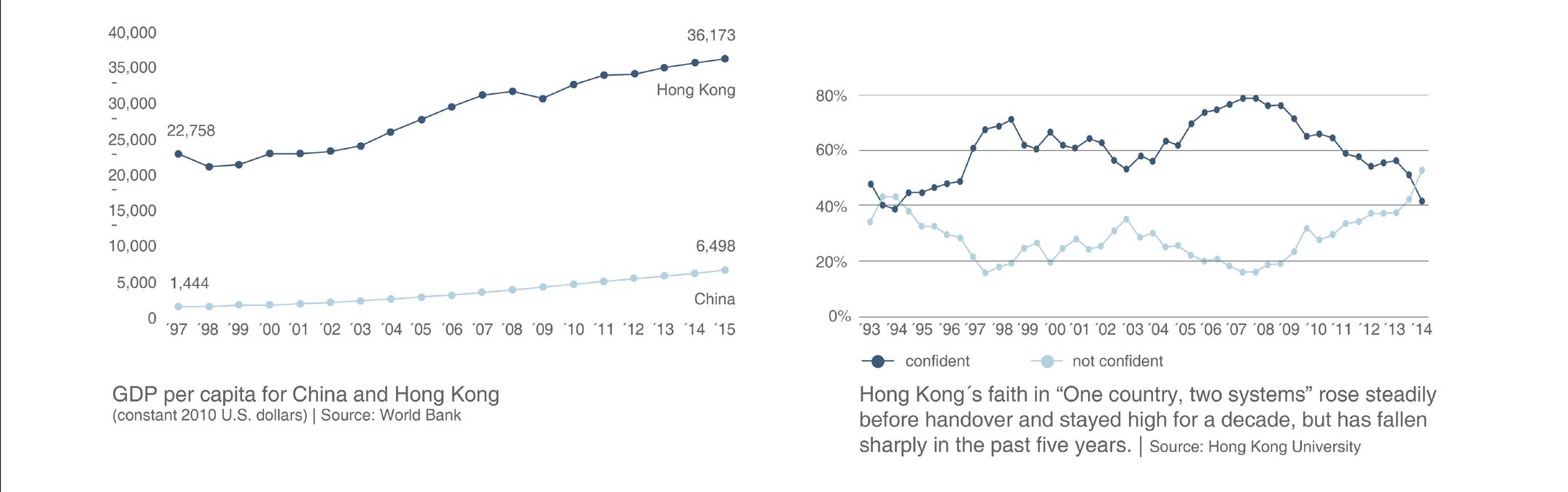
Hong Kong. Similarly, Macau - a former Portuguese colony - was provided with a high degree of autonomy after being reunified with China in 1999. The framework will remain unchanged for up to 50 years. Hong Kong’s economy has been one of the freest in the world since 1995 (The Heritage Foundation). It attracts international corporations thanks to its low tax regime, low corruption (The Corruption Perceptions Index 2019) and business-friendly environment.
However, recently China has passed a new security law that challenges Hong Kong’s autonomy and might influence freedom of expression and security in SAR. It might also have an impact on the relations between foreign countries and businesses with Hong Kong and China. Hong Kongers’ confidence in the “One country, two systems” policy has been failing in the last 10 years.
37
earth
Land use Aborem inveliqui quatectur anducil iaspel ipienimustio es et et?
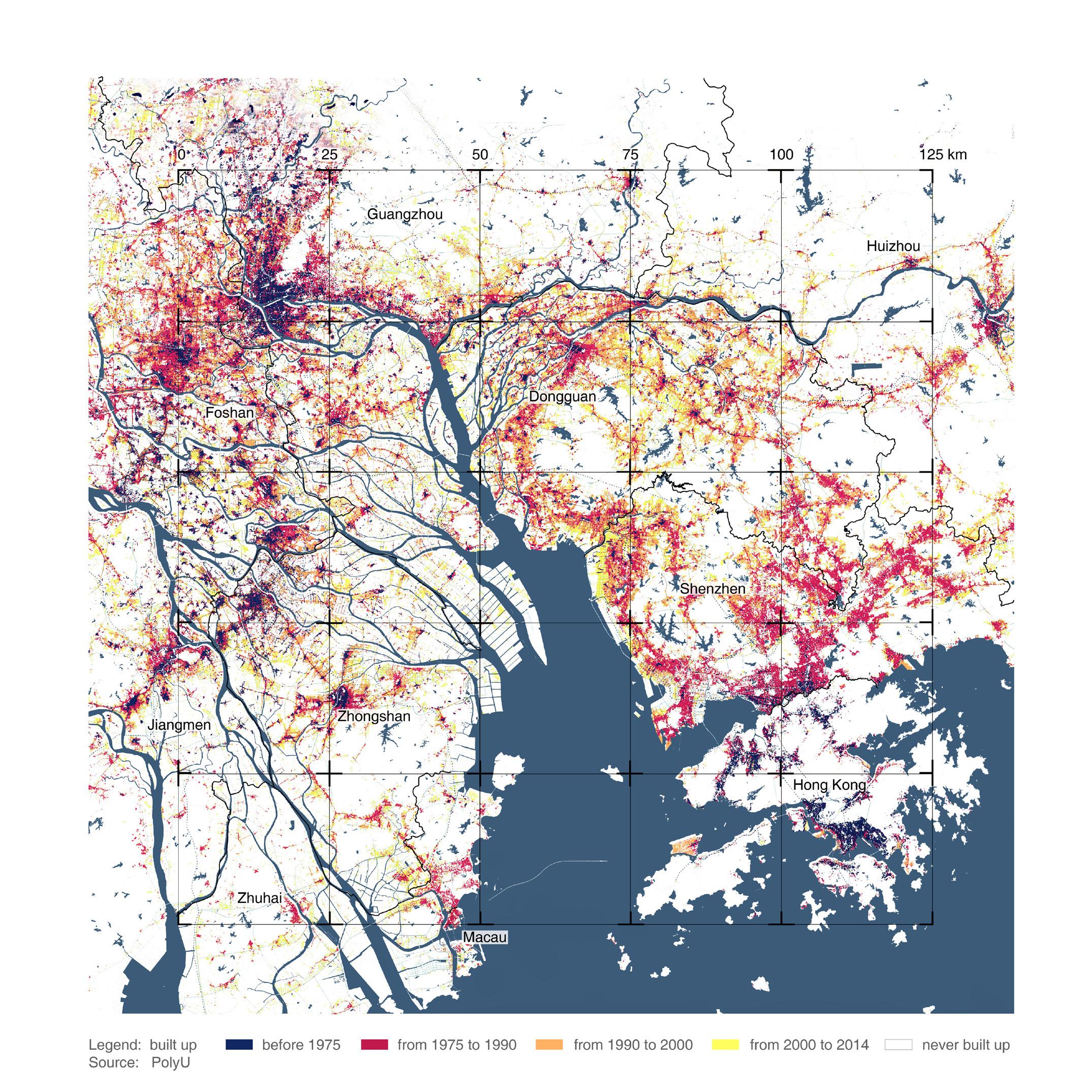
Historically, PRD was mainly a grain-producing area of China and farming played a dominant role until the 1980s (Indian National Science Academy, 2001). It also had a rich economy of aquaculture. Starting from the 1970s, as a consequence of three decades of rural industrialisation and the subsequent urbanisation, the region witnessed a dramatic expansion in the built-up areas. Rural industrialisation policies in the region led to a change in land use from the agricultural sector to the industrial sector. 38
sector. Large amounts of productive farmland were converted to built-up areas, 33.1% in 1973 to 17.6% in 1995 (Lei, 2014) to accommodate this growth. The urban-rural relationship has changed over time. This development led to water and land pollution, loss of farmland, as well as deterioration of the ecosystem and living environment (Carmona, 2014; Lei, 2014). The increase in the construction activity shows a direct relationship between the rapid urbanisation and change in land
use resulting in limited land capacity. Industrialisation is also closely followed by high migration causing increased construction activity over the past few decades. The labour-intensive manufacturing industries were dispersed geographically throughout the whole region. New manufacturing industries were established changing the morphology with the introduction of new amenities and infrastructure networks. Today, most of the region on the east bay is urbanised and the farming and aquaculture is concentrated on the west bay.
39
earth
Agricultural land and urban villages How did the urbanisation impact existing tissue of the region?
Urban Centre
Second tier towns
Villages
Growth pattern Urban Urban Centre Urban Centre Centre Second Second Second tier towns tier towns tier townsVillages Villages Villages Growth Growth pattern Growth pattern pattern
sion of the city encroaching andofvillages New urban centres Expansion developing of the city encroaching Existing towns structure networks New urban centers developing Existing Existing Existing structure structure structure of networks of networks of networks Expansion Expansion Expansion of the of city the ofcity encroaching the encroaching city encroaching towns towns and towns and villages and villages villages NewNew urban New urban centres urban centres developing centres developing developing towns and villages
Rapidly rising economy propelled internal rural to urban migration which transformed the cities of GBA into highly populated and urbanised centres. As a result of the urbanisation, there were swift transformations to agriculture and aquaculture lands resulting in the loss of biodiversity and farmlands. With limited land availability in urban centres, large areas of agricultural land are transformed for the sake of development. The capacity of ecological systems to produce food, catchment areas for fishing
40
and the biodiversity of the grasslands and grazing areas are on the decline. Another important consequence of this growth is the creation of urban villages. The development of these cities as a part of China’s urbanisation efforts often followed the incorporation model where the urban areas engulf these villages making them ingrained into their urban fabric. They appear on the outskirts and the downtown segments of major cities of GBA including Shenzhen and Guangzhou. These villages
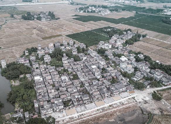
are usually seen as squalor, cramped spaces and unwanted side effects of urbanisation. However, they carry a cultural value and are surrounded by skyscrapers, transportation facilities and other urban systems. They are under threat to make way for further densification within the city. These patterns have created several vulnerable communities like the farmers who suffer the loss of their land, the inhabitants of the urban villages whose habitats suffer from the constant threat of gentrification.
source: Visual China Group
41
earth
Three olds What is the region’s strategy to gain more space for new developments?
Old town town OldOld town Old town Source: www.vcg.com Source: www.vcg.com source:www.vcg.com Source: www.vcg.com
The three olds in the region of GBA refer to the old towns, old factory sites and old villages. Since 2009, there has been a shift in urban development policies from the urban village and industrial district revitalisation to include the old residential sites, factories and business areas. These areas carry cultural and historic connotations along with them. The regeneration of three olds has become highly experimental and innovative. Foshan and Guangdong have already pioneered in successfully transforming the three olds as a part 42
Old urban villages Old urban villages Old urban villages Old urban villages Source: Village in the city Source: Village in the source:in Village incity thecity city Source: Village the
of their urban regeneration planning framework. These areas, if left unattended, contribute to inefficient land use and also to the pollution along the shores. More than 50 percent of the three old lands in Pearl River Delta is found within 500 metres of the water system, making them accessible through infrastructure systems (Guangdong Planning and Design Institute). The three olds regeneration also include industrial transformation, urban transformationand environmental reconstruction.
Old factory Old factory Old factory Old factory Picture credit: Edward Burtynsky Picture credit: Edward Burtynsky picture credit: Edward Burtynsky Picture credit: Edward Burtynsky
The existing footprints can be utilised to generate new functions in the area. These lands could become state-owned where necessary strategies are formulated to aid in the grander vision. On the other hand, the land’s owner can implement a self-transformation model giving way to the possibility of collaboration between the two processes. These lands aid in the city’s economic social and sustainable development. The project’s vision is to replace these three old issues with a combination of new and green tissues.
43
water
Inhabitation of water territory How do the water systems function in the Pearl River Delta?
total water use (100 million m³)
total water use trendline 1998-2008 trendline 2008-2016
25
PRD
Percentage
20
Old village
323.9
579.9
55.9
15
Old town
196.5
310.5
63.3
10
Old Industry
434
847.8
56.2
5
1995
1998
2001
2004
2007
2010
2013
2016 Year
Total Water Use in Shenzhen, 1998-2016 Source: Water Resources Bureau of Shenzhen
Total Water Use in Shenzhen, 1998-2016 Source: Water Resources Bureau of Shenzhen
The water ecology of the PRD is characterised by its diverse and complex water system and issues. The economy of GBA has closely followed the water networks. Over the past few decades, the interdependencies between land and water ecological systems have transformed drastically making the networks quite vulnerable. Since the urbanisation rates are uneven throughout the region, the dependency on water systems is also quite distinct in different cities. The utilisation rate of water
44
within 500 meters along waterline
Gaoling River Gate Source: Xijiang River Basin Administration of Guangdong Province
Gaoling River Gate
Source: Xijiang River Basin Administration of Guangdong Province
resources development is not to be more than 40%. The Dongjiang basin has a utilisation rate of 35.4% on average for many years due to its proximity to developing areas like Shenzhen and hence it cannot meet the rapidly growing water demands of the future. On the contrary, the Xijiang river which is rich in water resources is utilised by only 1.5% which accounts for the lowest degree of water resource development and utilisation in Guangdong province and hence has great developmental potential (Yun et al., 2011).
Existing situation of three olds within 500 meters along waterline in PRD Source: Guangdong Planning and Design Institute https://mp.weixin.qq.com/s/XQ2A_AjokScqjQSWy4OgtQ
Existing situation of three olds within 500 meters along waterline in PRD Source: Guangdong Planning and Design Institute
Since the continuous intake of water makes the river susceptible to seawater retrogression, the water quality cannot be guaranteed and is very unsustainable for future development. Therefore it is necessary to divert the water dependency and diversify the usage onto other rivers. The Outline of the “Guangdong-Hong Kong-Macao Greater Bay Area Development Plan” clearly points out that it is necessary to improve water conservancy infrastructure, implement and strengthen the drinking water resource systems.
Xijiang Dongjiang
Source: Chunlin Xu. (2014). Research on Water Security under the Impact of Human Activities in Pearl River Delta. Yun Dai, Yuanjing Yang, Hao Huang. (2019). Strategic Thinking of Water Resources Allocation in Greater Bay Area. Urban and Rural Development Journal, (12), 19.
45
water
Height of sea level chart(m)
1,55
Environmental risks
1,50 1,45
1954-2010 +26 mm/ decade
1,40 1,35 1,30 1,25 1,20
1954 1959 1964 1969 1974 1979 1984 1989 1994 1999 2004 2009
Annual mean sea-level at North Point/ Quarry Bay Source: Adapted from Zhang et al. (2011) 7
How vulnerable is Pearl River Delta?
1,50 1,45
1954-2010 +26 mm/ decade
1,40
No. of storm surges
Height of sea level chart(m)
1,55
1,35 1,30
6 5 4 3 2 1 0
1,25
1991 1992 1993 1994 1
Typhoon storm su Source: Adapted f
1,20
1954 1959 1964 1969 1974 1979 1984 1989 1994 1999 2004 2009
Annual mean sea-level at North Point/ Quarry Bay Source: Adapted from Zhang et al. (2011) 1954-2010 +26 mm/ decade
1,40 1,35 1,30 1,25
6 5 4 3 2 1 0
1,20
1954 1959 1964 1969 1974 1979 1984 1989 1994 1999 2004 2009
1991 1992 1993 1994 1995 1996 1997 1998 1999 2000 2001 2002 2003 2004 2005
Annual mean sea-level at North Point/ Quarry Bay Source: Adapted from Zhang et al. (2011)
Typhoon storm surges, PRD, 1991-2005 Source: Adapted from Zhang (2009)
Economic loss / Flooded population
30 25
No. of storm surges Precipitation / Typhoon
6
Annual mean sea level at North Point/ Quarry Bay
3500 5 3000 4 2500 3
source: adapted from Zhang et al. (2011)
20
2000 2
15
1500 1
10
1000 0
5 0
500
2000
2001
2002
0
2003 2004 2005 2006 2007 2008 2009 2010 2011
The PearlEconomic River Delta is located in the Precipitation (mm) loss (Billion RMB) (10 times) Flooded population (million person-time) low-lying land of the Pearl RiverTyphoon estuary. Loss in GBA due to typhoon and rainfall Source:is Adapted from Zhang et al. by (2011)a tropical The 35PRD characterised 30 - subtropical monsoon climate where ty25 20 phoons, storm surges, river changes and 15 10 intense rainfalls are a common occurrence 5 during the wet seasons. 0 2000 2001 2002 2003 2004 2005 2006 2007 2008 2009 2010 2011 In recent Economic times, the PRD has alsoPrecipitation been(mm)reloss (Billion RMB) Typhoon (10 times) Flooded population (million person-time) cording other extreme weather events like Loss in GBA due to typhoon and rainfall land subsidence, flooding drought. This Source: Adapted from Zhang etand al. (2011) resulted in both human as well as economic losses. The region is at particularly high flood risk due to its continuous urbanisation -2
46
3500
Precipitation / Typhoon
Economic loss / Flooded population
-2
3000 2500 2000 1500 1000 500 0
3500
30
3000
25
2500
20
2000
15
1500
10
1000
5 0
500
2000
2001
2002
2003 2004 2005 2006 2007 2008 2009 2010 2011
Economic loss (Billion RMB)
Flooded population (million person-time)
0
Precipitation (mm) -2
Typhoon (10 times)
Loss in GBA due to typhoon and rainfall Source: Adapted from Zhang et al. (2011)
7
35
35
Typhoon storm surges, PRD, 1991-2005
Loss in GBA due to typhoon and rainfall
source: adapted from Zhang (2009)
source: adapted from Zhang et al. (2011)
1991 1992 1993 1994 1995 1996 1997 1998 1999 2000 2001 2002 2003 2004 2005
Typhoon storm surges, PRD, 1991-2005 Source: Adapted from Zhang (2009)
exposing a large number of people to flood hazards. On the other hand, climate change and rising sea levels make the region particularly vulnerable. It also suffers from a lack of integrated planning between flood risk management principles and the spatial strategic framework. Unsustainable urbanisation model and land use change intensified flood risks (Wheater & Evans, 2009). By 2050, the PRD would record a further sea-level rise of 200 mm (Chen & Chen, 2002). According to China’s marine network system, if the sea-level rises
even by 100cm, 7,823 km2 area would be potentially flooded with the current defence systems in place. These environmental risks are particularly detrimental to the livelihoods of socially weaker sections. These realities need to be acknowledged and a comprehensive approach should be adopted for hazard mitigation. Softer flood mitigation systems like expanding coastal plains, creation of mangrove ranges and green embankments are more efficient mitigation systems.
Precipitation / Typhoon
7
1,45
Economic loss / Flooded population
1,50
No. of storm surges
Height of sea level chart(m)
1,55
47
water
Vulnerable edges How did the current development model influence water edges?
48
boulevard by Shenzhen Bay
hard water edge in Dongguan
soft water edge on the border between Dongguan and Shenzhen
The economy of GBA is highly facilitated by water altering the coastlines across the region over the last 50 years. The coastlines of PRD are very dynamic in nature with diverse functions. Due to rapid urbanisation and limited land availability, the land is reclaimed from the sea and these changes to the coastlines have contributed to the disappearance of mangroves, threat to biodiversity, creation of hard edges that are not resilient towards flooding, putting the area at grave risk for flooding today. The PRD is subject to 3 types of flooding,
coastal flooding, fluvial flooding and pluvial flooding. Around 86.7% of the PRD coastlines often rely on hard engineering infrastructures like dykes and embankments for flood protection but not designed to mitigate a one in 100 years storm surge (Cai et al., 2011).
the geomorphology of the edge systems negatively. Lack of proper sewage systems and the degree of greyness in the cities contribute significantly to pluvial flooding where the surface water cannot drain off in the account of heavy rainfall. Changes in natural conditions and human activities have seriously influenced the water-land edge dynamics, which have not been well coordinated by the current spatial planning and water management systems rendering these edges vulnerable to environmental risks (Chan et al., 2013). .
Hard edges are created for aiding economic activity, infrastructure and flood protection. Construction of upstream dams, levees, artificial riverbanks, diversion of river channels and land use change have altered
Degree of hardness
Pluvial flooding
Fluvial flooding
Coastal flooding 49
air
Air quality What is the cost of air pollution? What does the region deal with it?
Rapid urbanisation and development of industries led to a high level of air pollution in the region of Pearl River Delta. To examine the situation, a regional network of air quality monitoring stations was created in 2005. The area also invested in research programs to analyse the issue and formulate strategies aiming at increasing air quality. Stricter control measures were implemented, which were followed by closing down many factories that emitted high amounts of pollutants (Wan et al., 2011).
50
Primary pollutants such as SO2 and PM mainly affect industrial cities, whereas secondary pollutants are formed due to the oxidation processes, which are enhanced in the Greater Bay Area due to the increase of O3 levels in Hong Kong and Macau. It may have a strong impact on regional climate and public health (Lin et al., 2011). As stated in the GBD studies, ambient PM2.5 and O3 cause most premature deaths related to air pollution (Forouzanfar et al., 2016).
PM2.5 can cause diseases such as chronic obstructive pulmonary disease, coronary artery disease and stroke. The graphs above show that even though the emissions are on a decline, the number of deaths related to PM2.5 has not changed. This is attributed to the increase in the population. In the case of O3-related deaths, the number is much higher in the cities with a higher concentration of air pollutants from vehicles as well as increased population (Wu et al., 2019).
51
air
Poor living conditions How does the economic growth influence living conditions?
Housing prices in Hong Kong compared to other major cities
Statistics of poor living conditions in Hong Kong | source: Commision on poverty, 2015
Income inequality in GBA, Districution of pretax income source: Piketty and Qian, 2009; Benjamin et al., 2005
Due to the continuous economic activity in GBA, there were major changes to the environmental and social structures. Poverty remains a persistent feature of society at all levels of per capita income, including the highest. Along with it, accelerated economic growth brings its own forms of environmental crises, social dislocation and heightened social inequalities which the current market has not displayed any capacity or inclination to resolve (Dougass, 1991). Even though alleviating poverty is seen as the main driving engine behind
52
the economic restructuring, fair portions of such fruits of development are not obtained by the major sectors of the population (Midgley, 1984; 1995). There is a paradox of wanting to legitimise and redistribute economic fruits towards the masses and at the same time to encourage accumulation and serve class and corporate interest. This dichotomy is usually won by the interests of the few and makes the economy work for certain sectors of society. The poor concentrate near the new factories, live and work closely to polluting industries
which lower their health considerably. They also witness a weakening in the social and political construct of their communities. In urban areas like Hong Kong and Shenzhen, the rental prices have skyrocketed due to competitive markets forcing people to live in extremely small caged homes with no access to natural light and ventilation. These migrant workers are not a part of the Hukou System that provides them with any social rights or support. These voices are unheard and quite vulnerable.
53
Problem statement Research question: How can value-based integrated planning redirect the course of development in the Greater Bay Area towards a people-ecological centric equilibrium?
The Greater Bay Area has the highest recorded rates of urbanization and economic developments in the world. Historically a grain-producing region, PRD transformed dramatically into one of the largest emerging industrial centres in the world, where economic development is associated with rapid urbanization. Envisioned as a rural-industrial model that aimed to absorb surplus rural labour, this model, while contributing to the economic development of the region also caused significant environmental issues, such as water and air pollution, loss of farmland, as well as deterioration of the ecosystem and living environment (Carmona, 2014; Lei, 2014). Even though the GBA has the highest economic development and GDP of the country, it poses a grave challenge of having the highest income disparity worse than some developing areas of the world ( Xiaobin, Z., Li, Z., & Kelvin, S. T. O., 2004). With the economy shifting from manufacturing to service-based industry, the rates 54
of unemployment have been at a rise. There are limited efforts for capacity building and job opportunities for unskilled labour. Poverty concentration, creation of urban villages, unfair resource distribution and poor living conditions have become prevalent throughout the region. Majority of the people in GBA are a floating population, i.e. the migrant workers whose rights are non-existent and the farmers within the region are at a danger of losing their stake and identity causing socio-economic vulnerabilities.
The Pearl River Delta has one of the highest flood-risks in the world due to its continuing urbanization which exposes a large number of people to socio-ecological criticalities (Merz et al., 2010). The mitigation works ignore the ecological impacts and climate change. Vulnerable communities are at risk due to the lack of awareness and engagement with the authorities (Webster et al., 2005). There is a disengagement between flood management authorities and the planning authorities that have led to inefficient mitigation systems.
Climate change and the potential impacts have been extensive (Adger et al. 2003), posing one of the gravest environmental, economic, and security challenges the world is facing (Martens et al. 2009; Scheffran and Battaglini 2011). The cities of the Greater Bay area representing the most concentrated units of human society have also become the most vulnerable regions in the context of climate change (Stern 2007; IPCC 2007).
GBA’s development in the last five decades mainly focused on profit at the expense of its people and the environment. These shortcomings, if not addressed, would significantly put the area at risk for both socio-economic and socio-ecological challenges in the future. The new vision for GBA has to adopt resilience thinking where there is fair access to the resources for all the inhabitants rather than a few actors.
This project aims to transform the current economic-driven developmental model to a more people-ecological centric development which matches with the values and needs of the society today. 55
Strategic framework
SWOT analysis and matrix
58
After the analysis of the region through different lenses and scales, we identified the strengths, weaknesses, opportunities and
threats of this area. The next step is to formulate values that need to be propagated in the region. To do
this, we worked out a strategy matrix that would use the swot analysis to develop certain strategies to formulate the vision.
59
Values What are the values that lie in our vision? How are they related to the aforementioned issues?
Socio-Ecological Resilience
60
Climate adaptation
Biodiversity conservation
Healthy cities
Multiple values based on the vision are formulated. These include; the ecological values which revitalise and integrate natural and human systems; economic values which focus on preventing the exploitation of the region for the benefits of a few and giving new opportunities to people to evolve and adapt to uncertainties; and finally, the social values that aim to create safer living conditions, healthier lifestyles and equal opportunities and access.
Rapid urbanisation has contributed to a loss of biodiversity in the GBA. It is caused mainly by the creation of hard flood protection systems, conversion of land for industrial and residential purposes. Biodiversity plays a crucial role in maintaining healthy ecosystems. It influences the resilience of the environment and increases their ability to withstand the disturbances caused by environmental hazards and climate change.
Substantial areas of GBA are low-lying and are under sea level with a threat of flooding. Hard engineering systems were introduced to protect the vulnerable edges from rising sea levels, leading to problems such as air and water pollution or ground subsidence. Nature-based systems should be adopted as solutions to the changing climate and maintain resilience. They provide ways to purify water, clean soil and air (ASLA, 2018).
Socio-Economic Resilience
Well-being of people
Socio-spatial justice
Knowledge economy
The territory of the air refers to the well-being of the people and also their quality of life. The point of access to natural resources raises issues about the impact of this lack of accessibility on environmental degradation. When viewing environmental distress and poverty together, the major conclusion to be drawn is that the consequences of environmental deterioration fall heaviest on the poor (Cuentro et al.,1990). The new framework should include their
needs in the planning strategies. It has to address the relationships between healthy cities and well being of people. Existing inequalities within society have far-reaching consequences. Rural areas with poorer access to education and culture as well as urban areas with limited access to nature have a strong impact on people’s well-being. There are gaps in the income, even within the agricultural society. It is crucial for the improvement of quality of life to provide
just distribution of resources spatially and among different social groups. Bridging the knowledge gap that is prevalent in the area is one of the few ways to create new opportunities that would facilitate a better quality of life for the vulnerable communities. Developing a knowledge economy gives a great potential to boost prosperity and at the same time diversify the national economy, therefore make it more resilient to economic crises.
61
Vision statement
Planet
Planet
Planet
+ People
Dynamic equilibrium Prosperity
Profit
People
Current trend CURRENT TREND Profit-minded
Profit - minded The project envisions the region of the Greater Bay Area as a system of resilient city networks which would achieve dynamic equilibrium contributing to a fair and equitable society, mindful usage of resources and overall sustainable development. These networks tackle the eccentricities and a myriad of ironies that are unique to this region and set a precedent for future growth. The new growth model would deviate from profit to prosperity with people and the planet as the main attributes. Knowledge is introduced both as a tool and a centrality 62
Strategy STRATEGY Resilience thinking
Resilience Thinking
Prosperity
People
Vision VISION Evolutionary resilience
Evolutionary Resilience
which aims to promote equal and fair access of the four territories of inhabitation to people.
social-ecological systems to change, adapt and transform to human or environmental induced stresses.
The vision proposes a value-based developmental model that is representative of people and their quality of life. It encourages a growth engine that focuses on building social and ecological resilience for the region. Evolutionary resilience is built by the co-evolution and cooperation between natural and human systems. Resilience thinking as a strategy would encourage not just fixing the previous shortcomings but also facilitate the ability of complex
Multifunctional, resilient areas are created at every scale making them an integral part of the regional system. Potentialities of these smaller areas are studied with people as the predominant agents of change. The vision generates platforms for everyone to voice their aspirations, to make informed decisions. The result is the creation of a resilient region that boosts fair growth and inclusivity, persistence and adaptability to achieve synergies between social-economic and social-ecological systems.
63
Morphological game
Building strategies with lines How did we proceed through the game? How did it help us build strategies?
66
tools
We started with identifying different structures that exist in the region. We used mainly threats to represent the current
using mesh. The denser it is, the denser is the population. In the picture below there are the three aforementioned structures.
populated as much. The game helped us to understand better this enormous region, to define main lines
networks, such as water network and city network. City centres, subcenters and new towns were marked as nodes. To have a better overview of the morphology of the region, we showed population distribution
From this image we can conclude that most of the population settled in Guangzhou and Shenzhen. On the other hand the areas with a dense network of rivers, therefore more vulnerable to flooding, were not
of potential development and to strengthen the currently existing networks. We explored different scales in order to come up with strategies to build resilience in the region.
current city network
67
Connecting green structures How could the green network be strengthened throughout the region?
68
current green network
Currently the green network is built-up of nature reserves which are not integrated with the green public spaces in the cities.
By connecting the existing green networks, we not only want to strengthen the connection between the east and the west bay but
green public spaces and “three olds” areas transformed into parks linked by streets with green pockets.
The number of the latter is also limited. The fragmentation of greenery in the urban fabric negatively influences the perception of the quality of it.
also increase the biodiversity in the region. Along with that green lines could be introduced linking the main stripes of greenery. These lines could consist of the existing
Another network analysed in this iteration was the industries network, which presently is located mainly in the east bay.
city centre
city subcentre
city connection
city subcentre
urban population density
industries
infrastructure
blue network
green network
connecting the green network
69
Developing three networks How can we build up a potential for further development in the west bay?
70
strengthening the flood management network
In order to strengthen the importance of the west bay in the further development process, there is a need of creating a robust
It consists of mangrove forests and wetlands in the areas adjacent to remaining agricultural lands and proposed city parks.
whereas tightly-tied threats represent hard edges. The knowledge-economy network is an-
and resilient system in that part of the region. To do so, we introduced a new green axis together with a network protecting the coasts and riverbanks from flooding.
The flood management system is also builtup of permeable hard urban edges which would have different levels. The loosely-tied threats represent soft natural edges,
other step to make the potentialities of the west bay area stronger. All three networks lead to a more even distribution of people and resources in the region.
city centre
city subcentre
city connection
city subcentre
urban population density
industries
infrastructure
blue network
green network
creating knowledge-economy network in the west bay
flood management knowledge-economy network
71
Nansha - Dongguan
72
macro scale
Thanks to Shenzhen Zhongshan bridge there are potentialities appearing in the west bay area.
the knowledge axis running perpendicularly to which the new functions would attract themselves to.
the coastline. The linearity here is used to segregate the different functions that happen along
The first zoom in shows the developmental possibilities along the dikes with
The second one however is more radial in nature because the orientation is towards
the coastline to make it functional as well as flood protective.
regional green axis natural edge hard edge urban waterfront with flooding protection
meso scale
intrusion, bio-infiltration flooding area flood protection protected nature
innovation industry axis developing axis developing node new knowledge core
clusters of 3 old cells infrastructure (highway) impact of knowledge-based flooding management
meso scale
73
Zhuhai - Zhongshan
74
macro scale
Zhuhai-Macau region will be the main attractor of the area, both for industry and living, recreation. The whole area will focus on
mainly along the coastal line and to the west, relieving certain urban pressure. Old areas are proposed for new industry
and wetland. One zoom in is located at the junction of Zhuhai and Zhongshan. The second one is
the development and land capacity recovery. The new development will extended
transformation and vertical farming, which are also connected to the ecology corridor
the subcenter under the impact of regional ecology and energy corridor.
regional green axis natural edge hard edge urban waterfront with flooding protection
meso scale
intrusion, bio-infiltration flooding area flood protection protected nature
innovation industry axis developing axis developing node new knowledge core
clusters of 3 old cells infrastructure (highway) impact of knowledge-based flooding management
meso scale
75
Shenzhen - Hong Kong
76
macro scale
The border between Shenzhen and Hong Kong is a very crucial location in the strategy strengthening connections between two
centres closer to the border, new potentialities of local integration are created. It can trigger the formation of new border crossings
the cities. To improve the attractiveness of Shenzhen side of the border and increase its
systems. By introducing new knowledge
and thus ease the people’s flow between
resilience, the softening of hard edges is proposed.
regional green axis natural edge hard edge urban waterfront with flooding protection intrusion, bio-infiltration flooding area flood protection protected nature innovation industry axis developing axis developing node new knowledge core clusters of 3 old cells infrastructure (highway) impact of knowledge-based flooding management
meso scale
77
Resilientthinking thinkingthrough throughlinear linearsystems systems Resilient How traslate strategies How dodo wewe traslate strategies through as medium? through lineslines as medium?
Buillt Ecology A
STRATEGIC FRAMEWORK A - Existing Situation - 2020 B - Integration - 2025 C - Catalyzation - 2030 D - Amplification - 2035 VISION - 2040
78
B
C
D
NANSHA
A. PRESENT 2 X 2 KM
B
Ecological corridor For biodiversity, flood protection
C
Socio-ecological resilience established
D
Evolution and Growth
ZHUHAI
A. PRESENT 2 X 2 KM
B
Buffer zone between farmland, fishponds and new development zones
C
Socio-ecological resilience established
D
Evolution and Growth
SHENZHEN
A. PRESENT 2 X 2 KM
B
Urban- green corridor connecting park and the river front.
C
New urban green/ recreational corridors bridging HK and Shenzhen
D
Improvement of living conditions, socio-spatial justice
79
Game conclusions What is our vision after the game?
80
The conclusion map shows three networks; green network, coastal protection systems and the knowledge axis. The green struc-
by local challenges and potentialities. Secondly, the Nansha area becomes the new centre of the knowledge economy.
shifted from the east bay. The new centralities achieved by this move create balance and establish synergetic growth across the
ture binds the whole region together by integrating ecological systems with the urban fabric. These lines represent multiple functions at local scales which are driven
This knowledge axis along with the economy and ecology axes establish new structures of development in the western bay of the GBA. The focus of development
region.
81
Manifesto
Manifesto
Seemingly endless resources are exploited in the process of development drastically changing the existing natural systems. Urbanisation is a complex process that requires social, political and environmental changes. However, these very alterations in return caused high stresses and disturbances in natural and human systems leading to socio-ecological criticalities in the region of GBA. External disturbances with the lack of foresight and regard to the ecological systems also made this region increasingly vulnerable to environmental hazards and risks. People, on the other hand, were sidelined from the decision-making process leading to socio-economic vulnerabilities.
84
For the longest time, profit over prosperity and well-being drove the regional development of the GBA. As a result, the fragility of the interdependency of territories of inhabitation came under intense strain creating a dangerous precedent for the future. These territories are complex and bound by human systems.
Urban centres cannot function independently and need ecosystems near and far to survive. These accessories lose their capacities to persist under constant demands. These multiple networks of systems need to be encouraged to build resilience by creating complex adaptive socio-ecological systems.
The human interventions, conscious or otherwise, have diminished the resilience of the region. Resilience thinking is crucial to building preparedness, persistence, adaptability and transformability of interdependent systems.
Building evolutionary resilience is a mutually dependent cross-system approach affecting both natural and human systems. Enabling people to become active agents of change can facilitate synergetic development to themselves, society and the environment. The silent stakeholders of the planet and future generations should be acknowledged to maintain the region in a state of dynamic equilibrium where the three pillars; people, planet and prosperity balance each other out.
Cities are living organisms that are vulnerable to change; resilience should be understood not as a static presence but a process to withstand these nonlinear unpredictable dynamics and patterns of abrupt changes.
85
Evolutionary framework for change
Multiscalar approach How did we build up our strategy? What scales did we look at?
At first, we wanted to understand the region as a whole. Therefore, we started with analysing it on the mega scale, regional scale and its importance and influence on the global scale. Then we identified different characters of the region and went further in its exploration through smaller scales. The strategies we came up with answered the challenges specific to particular scales. At the regional level, we identified and proposed predominant axes. For the macro scale, we chose the area of Nansha as an exemplary area and defined networks of attractions and development. From there, we dived into the meso scale showing three areas of different characters, namely urban, peri-urban and rural area. In each of them, we showed different interventions and initiatives in local scale - micro scale.
88
89
Principles and strategies What are the principles of our strategies? What strategies could be used in the three different areas?
To create a value-based system that aims at achieving evolutionary resilience in this area, we derived certain spatial principles. To enhance the socio-ecological resilience of the region, these design principles look at establishing fair relationships between
90
different territories and people. They promote sustainable and circular usage of resources and efficient risk mitigation methods through softer systems. To create socio-economic resilience, the principles explore different ways of diversifying resource
dependency like establishing multi-functional and productive landscapes. They encourage utilising local potentials for income generation, create opportunities for the vulnerable communities and connect networks of attractions to achieve a synergetic resilient region.
Fire
Air
Earth
Water
91
Mega scale How could the economy network be built-up in the region? How does it relate to the other two networks?
In the mega (regional) scale, we have three main networks of axes that we derived from the game - green axes, flood management axes and knowledge-economy axes. Although the first two can be developed at the same time in different parts of the region, the knowledge-economy axes are dependent on the existing and upcoming development. Therefore at this scale, we explored further the build-up of that network.
92
We started from Zhongshan-Shenzhen bridge, which is currently under construction and might have a significant impact on the development of GBA. It will help strengthen the west bay area by linking both coasts and thus easing the people flow. In our proposal, there is a focus on giving importance to the areas that were until now developed much slower, for instance, the Nansha area. We create a new sub-centrality in Zhongshan making it one of the most important nodes in the area. It is well
connected with other cities in the area creating a network of knowledge, economy, new housing and services developments. They are intertwined with a network of green public spaces linked to the nature reserves. All of these strategies influence the four territories: economy, land, water and air. The main aim of these proposals is to increase the resilience of the region and improve people’s quality of life.
93
Macro scale - Central heart - Nansha What are the potentialities in Nansha? Why was it used as an exemplary area?
Urban area
Peri-urban area
Rural area
We chose Nansha as an exemplary area for strategy building because saw it had several potentialities for development thanks to the bridge that is being constructed and new opportunities created with it.
Shenzhen. We want it to become an example for other areas.
the existing fish ponds and propose regeneration and restructuring of the three olds. In the rural area, on the other hand, we propose development next to the main infrastructure axes preserving the existing agricultural land and fish ponds. Some of the farmlands would be transformed into parks to improve the quality of living in the new settlements.
We could consider Nansha as “tabula rasa” where everything can happen. We chose it to show how evolutionary resilience could be built, how to smartly develop the area considering the challenges and the mistakes that were made for instance in
94
We identified three characters of the area: urban, peri-urban and rural to better address the challenges and propose more accurate strategies. The main issue which urban area faces is flooding and lack of green spaces, which is why we built strategies around these problems. The peri-urban area is threatened by urban sprawl and loss of identity. Here, we preserve
95
Urban area
The urban area between Shenzhen and Dongguan is prone to heat flashes and pluvial flooding due to the greyness of the infrastructure. The region has high levels of air pollution because it mainly houses industries and dormitories for the workers. The area has major water, roads and other infrastructure networks. There are no recreational or leisure places for these vulnerable communities to claim as their own or to provide buffers for the built areas. This area suffers from a drinking water shortage. The reclaimed lands are currently used for agriculture and industrial purposes.
96
97
Urban area - character and challenges
98
Intersection of infrastructures
Fragmented green structures
New reclaimed land from sea
Old residential and industrial areas
Hard canal edges
Aqua culture
99
Urban area - strategies
For the urban area, the strategies facilitate the accessibility of different resources to the vulnerable communities. It encourages establishing green buffer zones throughout the urban fabric which helps to manage
microclimate, provide public spaces for the migrant workers and also boosts the water table of the area. Creates platforms for these workers to develop new skills for the changing economy.
Interweaving existing urban fabric with green network and public spaces
Designing new developments with 40% green
100
Making urban areas sponge with permeable surfaces
Moderating microclimate and creating roofscapes
Establishing green axes to integrate with pedestrian routes of the areas
Strengtening and integrating local character to withstand the external pressures
Transforming cultural nodes with local artists
Water catchment areas for fair access
101
Urban area - meso scale How is the urban area being transformed?
Legend:
102
Establishing axes of networks
Identifying areas of regeneration
The urban areas are prone to heat flashes and pluvial flooding due to the greyness of the infrastructure. The urban fabric is integrated with green areas and provide public spaces that are accessible to all. Green axes are established connecting the existing urban parks, and built areas with the coastline. Along these axes, promenades and boulevards are created that softens the urban space. The 3 olds of the region are identified and replaced with green tissue.
Sponge areas are created to encourage water percolation and flood protection. This area suffers from a drinking water shortage, so water catchment areas maintain microclimate of the area and provide access to water systems to vulnerable communities. A vocational centre at the junction of these multiple ecological and human axes provides the new centrality to the region. The knowledge economy facilitates economic opportunities for unskilled labourers.
Proposing new multifunctional landscapes
The area also has a system of lands reclaimed from the sea. These lands are used now for agriculture and industrial purposes. Under the strategy, they are brought under the scope of ecological developments. Along with the fish ponds that act as cultural nodes, these new areas would have mangrove raves, ecological and wetlands parks which generate economy. This would incentivise their maintenance and be integrated with the built systems.
Ecological treatment for flooding
103
Urban area - micro scale What is the impact of the interventions on the local level? The interventions for this area are mainly about integrating green tissue with the existing urban fabric, creating new opportunities to the disenfranchised. The vocational centre is the main attractor that creates Legend:
104
public platforms for discussions and dialogue. The plugin area between the Shenzhen and Dongguan region aids in resource and knowledge sharing. The abandoned buildings are revitalised with circular
approaches and used for multi-functions like living and working. The smaller branches of water which are linear can be activated by introducing self-purifying plants. They also provide leisure for people.
105
People as agents of change How can local communities become active? How can they change their neighbourhoods?
The interventions in this area address the vulnerabilities of migrants and workers. The vocational centers provide them with new knowledge that could be used for gaining new employment opportunities. These institutes are used as platforms for discussion debate and decision making in a participatory approach. New technologies are introduced the citizens are encouraged to create sponge areas and increase their accessibility to different territories.
106
107
Peri-urban area
The peri-urban areas across the GBA are under a constant threat of urban sprawl and loss of identity. The area near the Panyu district has huge infrastructure networks cutting through them. It houses several old abandoned built areas like old factories and old houses that are in the need of regeneration and restructuring. It also houses agricultural lands and fish ponds. The presence of the industries add to the air and land pollution of the surrounding areas.
108
109
Peri-urban area - character and challenges
110
Agriculture and Aquaculture
Intersection of Infrastructures
Low-lying coastal areas
High-density residential blocks
Old industrial landscapes
Fragmented green structures
111
Peri-urban area - strategies
For the peri-urban area, the strategies formulated aim at protecting the local character but establishing developmental control
lines. They encourage sustainable usage of resources by regenerating old wastescapes and promoting multifunction land-
scapes like hybrid infrastructures. New developments should be circular and use clean energy sources.
Hybrid uses under highways
Replacing industrial cells with the green
112
Softening water edges
Circular developments for new and existing
Integrating sewage treatment with local knowledge
Green buffers at the edge of development
Aquaculture restoration
Mixed typologies of buildings and skylines
113
Peri-urban area - meso scale How is the peri-urban area being transformed?
Legend:
114
Establishing axes of networks
Identifying areas of regeneration
The peri-urban areas are under a constant threat of urban sprawl and loss of identity. Development control lines and agricultural conservation areas established will curb the development, protect the agricultural lands and conserve biodiversity. All of the fish ponds and the urban green structures are connected through green axes. They fracture the built fabric but integrating with green to provide buffer spaces and moderate the air quality.
The three olds are identified and regeneration lines are established where new interventions would be developed in the future. There’s an existing medical centre which forms the base for the establishment of the knowledge economy. Testing centres, workshops, research labs are created in this new centrality to boost this to the surrounding regions. The new centre encompasses medical centres, the three olds and
Proposing new multifunctional landscapes
the green areas and is transformed into a multifunctional space. For the creation of productive landscapes, agricultural lands will look at increasing the food production capacity with the help of new research centres. These areas along with the fish ponds also facilitate eco-tourism and agro-tourism for revenue generation. Multifunctional landscapes are created by using the existing infrastructure lines like highways to increase the efficiency of land use.
Ecological treatment for flooding
115
Peri-urban area - micro scale What is the impact of the interventions on the local level? At the micro-scale, the coastal edges are activated by the creation of waterfronts for recreational and ecological functions. Softer measures implemented for flood management also aids in the prevention Legend:
116
of saltwater intrusion. The industrial landscapes are transformed into a hybrid typology of living, working and technological areas. The main goals are ensuring fair
access to green areas and public spaces to the vulnerable communities, provide platforms for public participation and ensure sustainable resource usage.
117
People as agents of change How can local communities become active? How can they change their neighbourhoods?
The developments in this area would be mobilized by the locals through community discussions and collaborative approach. The health centre would be upscaled to train people for boosting their economic opportunities. It aims at increasing the quality of life by creating good living conditions for people by providing them with recreation and leisure activities along the coastal edges. Green networks would be integrated better with the urban fabric by introducing hybrid farming and urban parks. Farmers will look at diversifying their dependency, access new technology which would help them increase their productivity.
118
119
Rural area
The rural area in the Nansha district has lands reclaimed from water which are being used predominantly for agriculture and aquaculture. The area is highly floodprone. There is an existent system of flood protection measures in place like dykes. This area is still quite rural in nature with small villages along the dykes. The main potential of this region is the proposed bridge connecting the east and the west bay. This place is suitable to test out the strategies to explore sustainable ways of development without resulting in environmental degradation or loss of identity.
120
121
Rural area - character and challenges
122
Old industrial landscapes
Development along roads
Agriculture and aquaculture
Dykes and linear systems
Low-lying coastal areas
Prominent infrastructure axis
123
Rural area - strategies
For the rural area, the strategies revolve around protecting the agricultural fields, establishing synergies between local
potential and new technologies and creating multifunctional landscapes. It is important to make sure that the biodiversity,
local culture and ecological heritage is protected while new developments are proposed.
Promoting ecotourism by diversifying resources dependency
Enlarging areas for flooplains
124
Developing IoT with existing developments
Water purification and decreasing salt water intrusion
Fair percentages of affordable housing within new developments
Vocational centers upskilling local farmers
Productive landscapes and hybrid farming
Community area for public participation
125
Rural area - meso scale How is the rural area being transformed?
Legend:
126
Establishing axes of networks
Identifying areas of new development
The main potential of this region is the introduction of the bridge connecting the east and the west bay. The ecological axis proposed at the regional scale overlaps with the new infrastructure axes creating multiple potential nodes of development. The new developments follow the linear structures. A knowledge-based economy dealing with sustainable agricultural practices and research labs is established for the local farmers and the people from around
the region. This requires other support functions which are used as potentials to engage the coastline to provide incentives for their maintenance and conservation.
the local people in this process of development. The area is flood-prone, so coastal protection with sponge areas along the hard edges are created.
The agricultural land is protected with an establishment of development control lines and fish ponds become areas of eco-tourism and recreational areas that could be integrated with the cultural activities to encourage localised economy and engage
The coastline becomes multifunctional with the creation of wetland parks and leisure activities making sure the flood protection measures are softer, greener. There is a sense of porosity to provide room for the water in this process of development.
Proposing new multifunctional landscapes
Ecological treatment for flooding
127
Rural area - micro scale What is the impact of the interventions on the local level? The introduction of the knowledge centre acts as a catalyst for generating an economy. Local economies are protected and integrated with the new developments. At the local level, people get involved in this Legend:
128
transformation by diversifying their lands for different purposes. The coastlines are engaged with the new functions while ensuring softer buffer zones. The creation of new bridges facilitates easy access
to these knowledge centres. Museums, agro-tourism and ecological parks generate revenue but also represent the local culture of the area.
129
People as agents of change How can local communities become active? How can they change their neighbourhoods?
In rural areas, the farmers will collaborate with the research institutes to develop methods for increasing land productivity. The locals will participate in integrating cultural heritage and using that to generate the economy. All the fish ponds and the agricultural lands will be used for developing agro-tourism to give the citizens an integral role in this development. The recreational and leisure activities that will accompany the new development use the local human capital and resources by making the local population important stakeholders.
130
economic co-dependence
indigenous knowledge and local economy boost
biodiversity preserved
131
Planning framework
Planning framework and actors
The three main systems of collaborations are knowledge, social resilience and ecological cohabitation between human and nature. When we say cooperation, it is between universities, researchers planning institutes and local intelligence such as aquaculture. This is to promote the quality and effectiveness of the spatial performance within the region, and also facilitate access to different resources.
134
Due to the existing hierarchy of systems, higher amounts of resources and infrastructure concentrate towards certain urban areas within the delta region. Overlaying flows of people and information gives us an opportunity to establish new sub-centralities, thus extending the services and ecological systems beyond certain areas. The interweaving networks, to some extent, create balance the distribution and create exchanges with local interests.
Our goal is to increase the quality of life in the region of GBA by establishing resilient networks. The onion diagram on the right shows the multi scalar and multifunctional actors. It identifies the potential collaboration between vocational centres and vulnerable groups in this rapidly developing bay area and the co-working of ecological Institutes. These collaborations happen across municipal, regional and national scales.
Private
Designer Local
Private
Civic
Civic
Real Estate Developer
Local Committee
SMEs and Incubators
NGOs
Peasant Farmer Association
Public
Resource
Migrant
Industry Company
Vocational Center
Municipality Provincial Flood Affairs
Guangzhou Sponge City Water Affairs Bureau
Urban Construction and Landscape Bureau
Private
Civic
Planning Bureau Culture Tourism Authority
University State-owned Enterprise
National Energy Commission
Public
Public
Development
Private
Private
Civic
Environment
Actors
Relationships
Wider environment
Influencer
Strong collaboration
Secondary actors
Influenced
Ad-hoc collaboration
Primary actors
Civic
Indirect influence
Public
Cohabitation Public
135
Phasing
136
137
Final vision - GBA beyond 2030
The vision
140
climate adaptation
biodiversity conservation
healthy cities
well-being of people
socio-spatial justice
knowledge economy
Our project envisions the Greater Bay Area as a megaregion of resilient city networks, which would function in a state of dynamic equilibrium. These networks, social, ecological and economic, would contribute to a fair and equitable society, mindful usage of resources and overall sustainable development.
The vision proposes a value-based developmental model that is representative of people and their quality of life. It fosters a growth engine focusing on building social and ecological resilience for the region. Resilience thinking as a strategy fixes the previous shortcomings and also facilitates the ability of complex social-ecological systems
to change, adapt and transform to people or environmental induced stresses. The resilient network city proposal explores the interdependencies of complex systems in this megaregion and calls for a paradigm shift in thinking by prioritising people and planet through integrated regional planning.
city centre
city subcentre
city (sub)centre extend
green network
flood management network + land reclamation
new | existing knowledge/economy network
141
Evaluations
Space Syntax evaluation
We use space syntax to support spatial interventions based on current situation and assess the improvement of proposed spatial integration. With space syntax, we can see the potential of streets which might not directly relate to the hierarchy of itself. It also can imply the new centrality or location for new services.
We mainly test on road networks of meso scale. First one is global integration to see general integration of area. Existing industry and roads’ integration can suggest adjusting network density, public transportation distribution and air pollution control as well. Lands below 0.5m refer to the safety of streets and call for sponge development.
global integration, existing main road network of urban area 144
Emergency road systems are also put on agenda when flood comes. The second one is topological step depth of selected important axes to assess proposed changes, and to adjust planned movement and centers, such as the vocational or new market node along infrastructure or waterfront.
topological step depth of the selected cultural axis, proposed main road network of urban area
global integration, existing main road network of peri-urban area
topological step depth of proposed one main axis, proposed main road network of peri-urban area
global integration, existing main road network of urban area
topological step depth of the selected cultural axis, proposed main road network of urban area 145
Conclusions
Conclusion
Our project envisions the Greater Bay Area as a megaregion of resilient city networks, which would function in a state of dynamic equilibrium. These networks, social, ecological and economic, would contribute to a fair and equitable society, mindful usage of resources and overall sustainable development. The vision proposes a value-based developmental model that is representative of people and their quality of life. It fosters a growth engine focusing on building social and ecological resilience for the region. Resilience thinking as a strategy fixes the previous shortcomings and also facilitates the ability of complex social-ecological systems to change, adapt and transform to
148
people or environmental induced stresses. Building evolutionary resilience is a mutually dependent cross-system approach affecting both natural and human systems. Enabling people to become active agents of change can facilitate synergetic development to themselves, society and the environment. The silent stakeholders; the planet and the future generations should be acknowledged to maintain the region in a state of dynamic equilibrium where the three pillars; people, planet and prosperity balance each other out. The resilient network city proposal explores the interdependencies of complex systems in this megaregion and calls for a paradigm shift in thinking by prioritising people
and planet through integrated regional planning. To reach our aim, we used multiple experiments and tools like the morphological game and space syntax analysis which helped us understand the complexity of the region. It also provided us with certain methods to navigate through formulating the principles and translating them into spatial strategies. With our research, we wanted to shine a light on the importance of developmental model that has people, ecology and planet at its forefront to build a resilient region that can withstand the growing uncertainties of the future.
Group Reflection
The GBA is one of the most rapidly growing economies with extremely dense population nested in the fragile Pearl River Delta system. It went through a series of economic restructuring over the years that resulted in dynamic interrelationships between different systems. Through our analytical research, we could identify the negative consequences of such growth which need to be addressed immediately. The area has been studied intensely through multi-scalar approaches by architects, urbanists, landscape architects, sociologists etc. We are very pleased to have gotten the chance to contribute to such an amazing body of work that already exists in that part of the world.
This is been one of the most complex projects in terms of context, scale and sociopolitical disciplines that any of our team members have ever done. It has been quite a challenging experience but in the end, we are confident that our proposal ‘resilient city networks’ would add to the existing research and inspire many others to critically examine this region. As a part of the globalisation studio, we were supposed to visit any megaregion and study it by being able to physically move around the area understanding its morphology, culture and multiple complex systems that are in place. However, due to the extreme circumstances of the COVID-19 Pandemic, International travel
was restricted. We had to work through Zoom and Skype for the entire duration of the studio. Online medium of instruction did not restrict the capabilities of the studio or reduce the quality of the tutoring sessions. The success of the studio should be attributed to the amazing and efficient planning and organisation by the TU Delft tutors in collaboration with Poly U, Hong Kong and IFoU. We are very grateful to everyone involved and would like to thank all the mentors, lecturers for giving us their valuable time and guidance through these troublesome and uncertain times. This has been an extremely complex studio that has been carried out through great perseverance making it quite a memorable experience.
149
Relevance
Societal Relevance The relevance of the project is guided by addressing the socio-spatial justice for the marginalised groups and providing fair living conditions for these communities. We believe that by creating a platform which is open to discussion, debate and collaboration, we can set an example for collective growth and provide just societies for people to live in. Throughout our proposal, we have categorised overlapping themes and proposed interventions that would also align with the SDGs promoted by the United Nations, 2020. To ensure spatial justice, we create a participatory model where people collaborate and create sustainable and suitable
150
habitats, especially the weaker sections of the society. It strengthens the resilience of these communities and reduces their vulnerabilities. More people will be involved in decision making and swaying the policy decisions which would, in turn, facilitate strong partnerships. This system would ensure equal opportunities for everyone involved and become the catalyst to reduce inequalities. Scientific relevance The project ‘Resilient city Networks’ uses a body of theories. It has been driven by the fair sharing of knowledge perspective. The foundation for the proposed transitions was the re-envisioning the relationships between human and natural systems. What
we envisioned was tied together both theoretically and spatially by addressing need for resilient thinking. ‘Evolutionary resilience’ was explored, which broadens the description of resilience ‘beyond its meaning as a buffer for conserving what you have and recovering to what you were’ (Folke et al., 2010, p. 25), to incorporate the dynamic interplay between persistence, adaptability and transformability across multiple scales and time frames in ecological (natural) systems (Davoudi, 2012). Within the project, the necessities of fair sharing of knowledge were explored, explained and formulated.
Limitations and Recommendations
We tried to establish the relevance of resilience by identifying the potentials of each area of interest and demonstrating the opportunities that this model can achieve. This project deals with synergising local potentials with new technologies which is highly explorative and experimental in the context of China. As far as we are aware, the idea discussed has not been attempted at a scale as large as this with as many variations and stakeholders involved. Ethical Relevance The project functions by addressing four territories - Fire, Air, Water and Land. Our project focuses on making these territories accessible to people by utilizing the fair sharing of knowledge as the main driving
force. We have derived theories to emphasize that socio-ecological and socio-economic systems are interdependent. As explained in the conceptual framework, we have examined land and knowledge through the lens of the ‘tragedy of commons’. Limits and Recommendations To achieve a balanced development throughout the region and use smaller networks to their full potential, we encouraged to densify rural areas of the Nansha region the west bay. By doing this, we can start from a relatively intact area and propose developmental models that can learn from the mistakes of Shenzhen and Hong Kong region and better integrate blue and green
networks with the urban tissue. However, this requires strict guidelines to protect the farmland and the fish ponds. It also deviates from the GBA vision for 2040 but we believe this is the best course of action to alleviate some of the pressures on the already dense urban areas. Further research is required in the formation and phasing of these smaller proposed projects. To conclude, the proposed balance throughout the region would only be achieved with collaborations between the main city nodes and the network of multiple polycentric units. This model will only be successful if all the local actors are encouraged to take main roles and promote community participation at local levels.
151
References
Data sources
Google for the article, copy and paste here REMEMBER! While pasting Italic will be replaced by a regular style of font, don’t forget to change it back to Italic! --------------------------------------------------------------------------------------------------------------------------DATA SOURCES: Corruption Perception Index 2019. Retrieved from: https://www.transparency.org/en/cpi/2019/results/table Greater Bay Area. Gross Domestic Product and population of the cities. Retrieved from: https://www.bayarea.gov.hk/ Immigration Control Point Locations in Hong Kong. Retrieved from: https://www.immd.gov.hk/ Index of Economic Freedom. Retrieved from: https://www.heritage.org/index/country/hongkong Population change. Retrieved from: https://populationstat.com/ Real estate market outlook. Retrieved from: https://www.savills.com/prospects/data-opportunities-abound-in-the-greater-bayarea.html
TEXT REFERENCES: Adger, W. N. (2000). Social and ecological resilience: are they related?. Progress in human geography, 24(3), 347-364. Adger, W. N. (2001). Scales of governance and environmental justice for adaptation and mitigation of climate change. Journal of International development, 13(7), 921-931. Adger, W. N., Huq, S., Brown, K., Conway, D., & Hulme, M. (2003). Adaptation to climate change in the developing world. Progress in development studies, 3(3), 179-195. Carmona, D. S., Qu, L., & Tai, Y. (2014). Towards a Livable Urbanized Delta Region. Spatial Challenges and Opportunities of the Pearl River Delta. Revista M, 11(1), 8-23. Carpenter, S. R., Westley, F., & Turner, G. (2005) Surrogates for resilience of social-ecological systems, Ecosystems, 8(8), pp. 941–944.
154
DATA SOURCES: Corruption Perception Index 2019. Retrieved from: https://www.transparency.org/en/cpi/2019/results/table Greater Bay Area. Gross Domestic Product and population of the cities. Retrieved from: https://www.bayarea.gov.hk/ Immigration Control Point Locations in Hong Kong. Retrieved from: https://www.immd.gov.hk/ Index of Economic Freedom. Retrieved from: https://www.heritage.org/index/country/hongkong Population change. Retrieved from: https://populationstat.com/ Real estate market outlook. Retrieved from: https://www.savills.com/prospects/data-opportunities-abound-in-the-greater-bayarea.html
Literature references
TEXT REFERENCES: Adger, W. N. (2000). Social and ecological resilience: are they related?. Progress in human geography, 24(3), 347-364. Adger, W. N. (2001). Scales of governance and environmental justice for adaptation and mitigation of climate change. Journal of International development, 13(7), 921-931. Adger, W. N., Huq, S., Brown, K., Conway, D., & Hulme, M. (2003). Adaptation to climate change in the developing world. Progress in development studies, 3(3), 179-195. Carmona, D. S., Qu, L., & Tai, Y. (2014). Towards a Livable Urbanized Delta Region. Spatial Challenges and Opportunities of the Pearl River Delta. Revista M, 11(1), 8-23. Carpenter, S. R., Westley, F., & Turner, G. (2005) Surrogates for resilience of social-ecological systems, Ecosystems, 8(8), pp. 941–944. Chan, F. K. S., Mitchell, G., Adekola, O., & McDonald, A. (2012). Flood risk in Asia’s urban mega-deltas: Drivers, impacts and response. Environment and Urbanization ASIA, 3(1), 41-61. Davoudi, S., Brooks, E., & Mehmood, A. (2013). Evolutionary resilience and strategies for climate adaptation. Planning Practice & Research, 28(3), 307-322. Davoudi, S. (2012a) Resilience, a bridging concept or a dead end?, Planning Theory and Practice, 13(2), pp. 299–307. Douglass, M. (1992). The political economy of urban poverty and environmental management in Asia: access, empowerment and community based alternatives. Environment and Urbanization, 4(2), 9-32. Douglass, M. (1991). Transnational capital and the social construction of comparative advantage in Southeast Asia. Asian Journal of Social Science, 19(1), 14-43. Doulet, J. F. (2008). Where Are the Chinese Cities Heading?. Three Approaches to the Metropolis in Contemporary China. China Perspectives, 2008(2008/4), 4-14. Driessen, P. P., Behagel, J., Hegger, D., Mees, H., Andresen, S., Eboli, F., ... & Laessoe, J. (2013). Societal transformations in the face of climate change. Joint Programming Initiative Connecting Climate Change Knowledge for Europe (JPI Climate), 1. Du, S., Shi, P., & Van Rompaey, A. (2014). The relationship between urban sprawl and farmland displacement in the Pearl River Delta, China. Land, 3(1), 34-51.
155
China Perspectives, 2008(2008/4), 4-14. Driessen, P. P., Behagel, J., Hegger, D., Mees, H., Andresen, S., Eboli, F., ... & Laessoe, J. (2013). Societal transformations in the face of climate change. Joint Programming Initiative Connecting Climate Change Knowledge for Europe (JPI Climate), 1. Du, S., Shi, P., & Van Rompaey, A. (2014). The relationship between urban sprawl and farmland displacement in the Pearl River Delta, China. Land, 3(1), 34-51. Eriksen, S. H., Nightingale, A. J., & Eakin, H. (2015). Reframing adaptation: The political nature of climate change adaptation. Global Environmental Change, 35, 523-533. Friedmann, J. (1989). Collective self-empowerment and social change. Ifda Dossier 69, 3-14. Forouzanfar, M. H., Afshin, A., Alexander, L. T., Anderson, H. R., Bhutta, Z. A., Biryukov, S., ... & Cohen, A. J. (2016). Global, regional, and national comparative risk assessment of 79 behavioural, environmental and occupational, and metabolic risks or clusters of risks, 1990–2015: a systematic analysis for the Global Burden of Disease Study 2015. The lancet, 388(10053), 1659-1724. Lin, M., Chan, I. N., Chan, C. Y., Wang, X. M., & Dong, H. Y. (2011). Emerging Air Pollution Issues in Changing Pearl River Delta of South China. The Impact of Air Pollution on Health, Economy, Environment and Agricultural Sources, 199. Guo, Y., Chang, S. S., Sha, F., & Yip, P. S. (2018). Poverty concentration in an affluent city: Geographic variation and correlates of neighborhood poverty rates in Hong Kong. Plos one, 13(2), e0190566. Holling, C. S. (1961) Principles of insect predation, Annual Review of Entomology, 6(1), pp. 163–182. Holling, C. S. (1973) Resilience and stability of ecological systems, Annual Review of Ecological Systems, 4,pp. 1–23. Holling, C. S. (1986) The resilience of terrestrial ecosystems: Local surprise and global change, in: W. C. Clark & R. E. Munn (Eds) Sustainable Development of the Biosphere, pp. 292–317 (London: Cambridge University Press). Holling, C. S. (1996) Engineering resilience versus ecological resilience, in: P. C. Schulze (ed.) Engineering Within Ecological Constraints, pp. 31–45 (Washington, DC: National Academy Press). Holling, C. S. (2001) Understanding the complexity of economic, ecological, and social systems, Ecosystems, 4(5), pp. 390– 405. Holling, C. S., & Gunderson, L. H. (2002) Resilience and adaptive cycles, in: L. H. Gunderson & C. S. Holling (Eds) Panarchy: Understanding Transformations in Human and Natural Systems, pp. 25–62 (Washington, DC: Island Press). Kang, V., & Groetelaers, D. A. (2018). Regional governance and public accountability in planning for new housing: A new approach in South Holland, the Netherlands. Environment and Planning C: Politics and Space, 36(6), 1027-1045. Kasperson, R.E., Kasperson, J.X., Turner, B.L., Dow, K. and Meyer, W.B. (1995). Critical environmental regions: concepts, distinctions and issues. In Kasperson, J.X., Kasperson, R.E. and Turner, B.L., editors, Regions at risk: comparisons of threatened environments, Tokyo: United Nations University Press, 1–41. Kasperson, J. X., Kasperson, R. E., & Turner, B. L. (1996). Regions at risk: exploring environmental criticality. Environment: Science and Policy for Sustainable Development, 38(10), 4-29. Kates, R.W . and Clark, W .C. (1996). Environmental surprise: expecting the unexpected. Environment 38, 6–11, 28–34.
156
Lai, Y., Peng, Y., Li, B., & Lin, Y. (2014). Industrial land development in urban villages in China: A property rights perspective. Habitat International, 41, 185-194. Lai, L. W. C., Ho, D. C. W., & Leung, H. F. (2005). Planning conditions in Hong Kong. Property Management. Lankao, P. R., & Qin, H. (2011). Conceptualizing urban vulnerability to global climate and environmental change. Current opinion in environmental sustainability, 3(3), 142-149. Liu, Z., Huang, H., Werners, S. E., & Yan, D. (2016). Construction area expansion in relation to economic-demographic development and land resource in the Pearl River Delta of China. Journal of Geographical Sciences, 26(2), 188-202. Ostrom, E. (1990). Governing the commons. Cambridge: Cambridge University Press. Rijsberman, M. A., & Van de Ven, F. H. (2000). Different approaches to assessment of design and management of sustainable urban water systems. Environmental Impact Assessment Review, 20(3), 333-345. Schipper, L., & Pelling, M. (2006). Disaster risk, climate change and international development: scope for, and challenges to, integration. Disasters, 30(1), 19-38. Soyinka, O., & Siu, K. W. M. (2017). Investigating informal settlement and infrastructure adequacy for future resilient urban center in Hong Kong, SAR. Procedia engineering, 198, 84-98. Walker, G. (2009). Beyond distribution and proximity: exploring the multiple spatialities of environmental justice. Antipode, 41(4), 614-636. Wan, J. M., Lin, M., Chan, C. Y., Zhang, Z. S., Engling, G., Wang, X. M., ... & Li, S. Y. (2011). Change of air quality and its impact on atmospheric visibility in central-western Pearl River Delta. Environmental monitoring and assessment, 172(1-4), 339351. Wang, L. (2019). Changing Spatial Elements in Chinese Socio-economic Five-year Plan: from Project Layout to Spatial Planning. Springer Singapore. Wu, X. (2009). Income inequality and distributive justice: A comparative analysis of mainland China and Hong Kong. The China Quarterly, 200, 1033-1052. Wu, Z., Zhang, Y., Zhang, L., Huang, M., Zhong, L., Chen, D., & Wang, X. (2019). Trends of outdoor air pollution and the impact on premature mortality in the Pearl River Delta region of southern China during 2006–2015. Science of The Total Environment, 690, 248-260. Xiaobin, Z., Li, Z., & Kelvin, S. T. O. (2004). Income inequalities under economic restructuring in Hong Kong. Asian Survey, 44(3), 442-473. Yang, L., Scheffran, J., Qin, H., & You, Q. (2015). Climate-related flood risks and urban responses in the Pearl River Delta, China. Regional Environmental Change, 15(2), 379-391. Yun Dai, Yuanjing Yang, Hao Huang. (2019). Strategic Thinking of Water Resources Allocation in the Greater Bay Area. Urban and Rural Development Journal, (12), 19.
157
TU Delft April - July 2020