
SURVEYING SPATIAL March 2023 #111 Magazine SATELLITE IMAGERY: THE OLD AND THE NEW REALITY CAPTURE: EVOLVING CONCEPTS AND NEW TECH S+SNZ NEW CERTIFICATION FRAMEWORK Then and NOW

The Trimble® Business Center aerial photogrammetry solution brings advanced aerial photogrammetry workflow capabilities together with existing survey workflow and data processing features. Manage all your aerial photogrammetry, survey, and construction data within one software platform and

reduce the time and cost of multiple software solutions for your projects. The streamlined workflow, fast adjustment speeds, high-quality deliverables, UAV integration, and other features provide you with everything you need to support your projects from fly to finish.

s we continue to make major strides in the use and development of new technologies, it seems to be a timely opportunity to look back at some of the changes that have occurred in the survey and spatial industries over the past few decades.
The introduction of new technologies and developments has not only increased the efficiency of work, but in many cases, it has changed the way survey and spatial professionals approach work altogether, resulting in less need for continuous on-site presence, creating more scope for office-based data gathering and greater remote working activity.

As recalled in Walter Frick’s article in Harvard Business Review, American physicist and early microchip pioneer Robert Noyce held up a new Intel 4004 microprocessor to his relatives at a reunion in California in 1971 with a visionary prediction. “This is going to change the world,” he said. “It’s going to revolutionise your home; you will all have computers. You will have access to all sorts of information, everything will happen electronically.”
Noyce’s prediction has proved to be prophetic. In the 21st century we
cannot imagine our modern existence without the technology that started it all and the convenience it brings to our daily lives today.
Our technologies will continue to innovate and evolve but perhaps one thing that will never change is our continual need for products and services that ensure greater accuracy, information and detail. The new emerging technologies occurring in the survey and spatial sectors today are setting the bar very high for the future.
In this first edition for 2023 we’re focusing on the theme ‘Then and Now’, taking a look at some of the progress and innovations that have taken place in the survey and spatial space.
Global Survey’s Kirsty Mackie outlines the development of reality capture and how this technology is changing the way people work and their ability to deliver more efficient and mobile solutions into the future.

From Toitū Te Whenua-Land Information New Zealand, Toni Hill presents a compilation of ‘then and now’ photos from a LINZ team’s recent visit to Antarctica that reveals some of the new and enduring practices used on the frozen continent.
Critchlow Geospatial’s Group Managing Director Steve Critchlow takes a look at the evolution of satellite imagery technology, from 1960s images constructed from individual photos to today’s state of the art, high-definition imagery that can be used to inform quickly and efficiently.
Also in this edition, Survey + Spatial NZ presents the official launch of the Survey and Spatial New Zealand Certification Framework. This new framework, the result of a successful 2022 pilot programme, is the first of its kind in New Zealand and will provide a recognised professional pathway for S+SNZ members at all levels, and ensure mandatory continuing professional development. This edition, we outline the criteria and feature some participants from the certification pilot programme. •
A publication of Survey and Spatial New Zealand, Tātai Whenua. ISSN 2382-1604 www.surveyspatialnz.org
EDITOR
Rachel Harris surveyingspatial@gmail.com

All rights reserved. Abstracts and brief quotations may be made, providing reference is credited to Surveying +Spatial. Complete papers or large extracts of text may not be printed or reproduced without the permission of the editor.
Correspondence relating to literary items in Surveying+Spatial may be addressed to the editor. Papers, articles and letters to the editor, suitable for publication, are welcome. Papers published in Surveying+Spatial are not refereed. All correspondence relating to business aspects, including subscriptions, should be addressed to:
The Chief Executive Survey and Spatial New Zealand PO Box 5304 Lambton Quay Wellington 6140 New Zealand Phone: 04 471 1774 Fax: 04 471 1907
Web address: www.surveyspatialnz.org


Email: admin@surveyspatialnz.org
Distributed free to members of S+SNZ. Published in March, June, September and December by S+SNZ.


 Steve Critchlow, Group Managing Director, Critchlow Geospatial
There is perhaps no better example (or visual comparison) of the evolution of spatial technology than satellite imagery technology – and the importance of this technology has never been more critical than today. The image below was taken on Tuesday, February 21 in Puketapu, Hawke’s Bay, a week after Cyclone Gabrielle hit.

As the country navigates its way through this latest natural disaster, knowing that authorities today can rely on the availability of such highly detailed data shows just how far we’ve come.
But let’s go way back to the beginning when the NASA weather satellite TIROS-1 sent the first picture of Earth from
space on April 1, 1960. It was obviously both revolutionary and revelatory to view imagery of this kind for the very first time.

Satellite imagery and associated technology, of course, has advanced significantly since the launch of Landsat 1 in the 1970s (perhaps not as quickly as many geospatial experts would like).
In truth, until pretty recently, satellite imagery technology had been a source of great frustration – so much potential, but it was clear that potential wouldn’t be realised fully until next generation optics (and supporting technology) came on stream.
Adding to this frustration was the knowledge that if you didn’t have serious in-house expertise, as well as the required (and expensive) hardware/software, then any real-world business applications were largely out of reach for most organisations.
Quite simply, these limitations meant that for many years, satellite imagery technology just wasn’t ready for mainstream use and subsequently was never adopted at the scale that its initial promise suggested it would be.
Today, it’s a different story.
Quietly and somewhat behind the scenes, over the past few years, satellite imagery technology has properly come of age.
Back then, of course, the images were constructed by stitching together thousands of individual photographs; and it was really only possible to discern land and water boundaries, or large scale cloud formations.
The next big technology leap occurred on July 23, 1972, when the Landsat 1 satellite was launched. That’s really where modern ‘earth observation’ satellite imagery technology (as we know it) started.
The impact on cartography and the geospatial sciences of Landsat 1 data cannot be overstated: it was immediate and fundamental; country boundaries were redrawn and new islands discovered.
Within days of the launch, Landsat 1 captured imagery of an enormous fire burning in central Alaska, allowing scientists to see, for the first time, the extent of fire damage via satellite while it was still burning.
Landsat 1 was in service for over six years and, during that time, obtained images that covered nearly 75% of Earth’s surface.
Equipped with cameras and instruments operating in both the visible and near infra-red spectral bands, Landsat 1 was capable of up to 80-metre ground resolution.
The first advances in enhancing the data with computer technology and software were also pioneered during this time, allowing some of the spectral band data to be digitally processed and improved.
Today, providers can routinely offer native 30cm resolution and derived resolution high-definition imagery (via algorithms) of 15cm.
In addition, the recent advances in optics, remote sensing, artificial intelligence, machine learning and cloud computing now mean satellite imagery is more powerful and accessible than ever before and is driving newer and ever more granular applications.
This complementary technology is further enabling the use of multispectral and hyperspectral capabilities allowing users to more quickly and easily visualise and monitor change, as well as determine and distinguish between material features on the surface of Earth.
Multispectral imaging works by capturing image data within specific wavelength ranges from across the electromagnetic spectrum. This can include frequencies such as infrared and ultra-violet – these are wavelengths beyond the visible light range for humans and allow for the extraction of information that the human eye would be unable to capture.
With multispectral satellite imagery, it is possible to differentiate materials by what is known as their ‘spectral reflectance signatures’. These unique ‘fingerprints’ enable identification of materials, for example, the spectral signature for oil can help detect and ascertain the area of
Earth in 1960.oil spills at sea.
Hyperspectral imagery is next level again and enables segmentation and classification of land and aquatic features to a very granular level (but of course, like anything to do with satellite imagery – also at scale).
For example, hyperspectral imagery can identify and quantify molecular absorption, inferring biological and chemical processes, and has been used in this capacity to monitor the application of pesticides for quality control and optimum dose coverage.
When you combine all these advances in detection, processing power and accessibility with the capability for new imagery to be captured daily, you have an incredibly powerful tool for understanding and anticipating change (both human created and natural).
This kind of easy access and on-demand intelligence is ideal for assessing risk, monitoring land use, and planning infrastructure and development.
The applications for environmental protection and emergency response are also huge, particularly when you consider the ability of SAR imagery to penetrate both smoke and cloud cover.
With over 20 years’ worth of vast imagery archives now readily accessible, satellite imagery provides unique historical context around change to our planet via what is essentially a ‘then and now’ digital time machine.
These archives also plainly highlight the difference between satellite imagery technology in its infancy and what it is capable of today. As is often the way in geospatial, the difference between then and now is most powerfully demonstrated visually.

Below is the first image of Earth from space taken by TIROS-1 on April 1, 1960. Compare that with the Capella image.

Clearly, the difference in resolution between the very first satellite images of the 1960s and the latest satellite imagery is obvious and striking. However, even this doesn’t fully
One of the most significant advances in satellite imagery technology recently is the commercial availability of synthetic aperture radar (SAR). This technology uses radar to capture images of Earth’s surface, and depending on the use case, its capabilities are far more powerful than optical satellite imagery. This includes enhanced change detection capabilities and SAR’s ability to penetrate cloud, smoke and darkness.
Cloud computing and flexible new business models around the data licences for software and data make it easier and more cost-effective than ever to access satellite imagery in a timely and automated manner.
Source: Capella Space; Westport, New Zealand February 4, 2022, 4:27pm NZT (water displays as black).
capture the recent revolution in derived data, processing, and accessibility – and speed!


The extra high resolution imagery available through Charming Globe that was recently captured for the entire east coast of the North Island took 1 minute and 11 seconds.
juxtaposition in capability and utility. It’s this very recent convergence of a lot of disparate technology (machine learning, AI, cloud computing and optics) that makes the contrast between today’s satellite imagery technology and what’s gone before so dramatic.
Indeed, there is no doubt that satellite imagery and its derived data can now be used in myriad ways to inform decision-makers, quickly, easily and affordably. •
Sources:
https://www.usgs.gov/landsat-missions/landsat-1

The New Zealand Satellite Imagery Marketplace is an online resource provided by Critchlow Geospatial. It offers the most comprehensive range of satellite services available today.


Current providers include Maxar, NTT Data, Pixxel, SI Imaging, Head Aerospace, Capella Space, Charming Globe, Satellogic and SpaceWill.

For more information about the New Zealand Satellite Imagery Marketplace visit: https://www.critchlow.co.nz/satellite-imagerymarketplace
Source: Charming Globe, Coverage Map, February 21, 2023
A ‘then and now’ comparison conducted only a few years back wouldn’t have presented quite the same jarring
Charming Globe that was recently captured for the entire east coast of the North Island took 1 minute and 11 seconds.
When people say ‘reality capture’, they often mean devices that produce point clouds. But, at a fundamental level, reality capture is capturing the real world and creating a 3D digital representation of it. Isn’t this what surveyors have been doing since day one?


Newer reality capture methods such as terrestrial laser scanning (TLS) and photogrammetry have developed from the principles of traditional surveying. In a relatively short amount of time, we have gone from selectively capturing 1 GNSS shot per minute, to non-selectively getting 2 million points per second with the Leica RTC360 laser scanner.
The efficiency gains that newer methods offer over traditional methods (GPS and total stations), particularly for large or remote sites, are immense. Newer methods enable more data to be collected, faster delivery and great visualisation power in end outputs. As a result,
UAV photogrammetry and TLS are globally fast becoming embedded in the surveyor’s toolkit.
The traditional methods of reality capture obviously do still have their place, but it’s all use case specific. The computer requirements and big data management involved with newer methods is immense, and not always necessary for what you’re trying to achieve. Whilst GNSS and total station instruments are still the domain of the surveyor, laser scanners and photogrammetry have a much wider array of use cases across a business and throughout different industries.
Myths about all point clouds ‘being the same’ and laser scanning just being ‘point and shoot’ are being perpetuated. A key point of difference

for surveyors is the ability to get millimetre precision from these point cloud outputs.
Reality capture is not a point solution, the use cases are manifold and diverse. But often newer methods are adopted in a business as a point solution. Deliverables are regularly focused on the ‘mm precision’ element of the outputs. However, this emphasis can detract from the 3D visuals that are delivered. Visualisations are a powerful tool for stakeholder engagement in their own right. Frequently the end outputs are 2D drawings with their own symbology and layering language, seeing a visual of as-built conditions can be a
much more effective communication tool.
Your client, who may not be experienced at looking at these plans, can struggle to understand the design intent and physicality of the structure as seen in a 2D format. With the 3D visualisations that newer reality capture methods produce, all stakeholders can now see and interact with the design. This enabling them to intuitively understand as-built conditions as a basis for discussion about proposed changes. These visualisations are also very powerful for condition assessment and continual management of remote assets.
The development of this technology is changing how we work and what we deliver, and with pushes towards autonomy, e.g. the development of autonomous mobile mapping capture solutions or automated extraction workflows, this is a continuously
With the 3D visualisations that newer reality capture methods produce, all stakeholders can now see and interact with the design.
evolving process. So it is important that you have a digital strategy for the adoption of this technology across your business.
On top of this, new reality capture software and hardware are released every day. It is like we are on a long train ride with an unknown destination. With emerging technology arriving at pace, we are said to be in the grips of a fourth industrial revolution – the industry 4.0, as McKinsey & Company are calling it. As a result, our BAU processes are changing – but are we changing? “Surveyors as the data managers” has become an industry catchphrase. Are you observing this catchphrase or is your company actively adapting?
A key part of my role at Global Survey is to be the expert and stay up to date with emerging technology in this space. This is a challenge because of the volumes of new hardware and software coming out every day. My time is mostly spent providing technical training and support for our customers on their reality capture digital journey, refining workflows, consulting on best practice. My job enables me time to do this research, but in a consult role you likely won’t have this research time. How is your team staying up to date?
Cross-department collaboration is often the key element. As soon as a point cloud leaves your company, it’s really hard to retain disclaimers on its quality. Any ‘bad’ data that has gone out there has come from your company, not a specific department, so it’s important there are is collaboration and quality assurance processes in place.
A successful digital strategy for the deployment of reality capture methods is also is key to recruitment
and retention which, currently, in the surveying industry is critical. One of the things I’ve observed, is that it’s the companies that have good internal cross company collaboration that are most successful. Discussing different use cases across different departments is key. Having lessons learn on large TLS scanning jobs is critical!

Planning how you adapt to technology is imperative.
As Benjamin Franklin put it, “By failing to plan, you are preparing to fail.”
What is your digital strategy for the adoption of reality capture technology? •
Email: kirsty@globalsurvey.co.nz
Follow Kirsty on LinkedIn: https:// www.linkedin.com/in/kirsty-mackie
Reference: https://www.geoweeknews.com/news/realitycapture101
. . . new reality capture software and hardware are released every day. It is like we are on a long train ride with an unknown destination.
The development of this technology is changing how we work and what we deliver, and with pushes towards autonomy, e.g. the development of autonomous mobile mapping capture solutions or automated extraction workflows, this is a continuously evolving process.


Toitū Te Whenua–Linz
A team from Toitū Te Whenua Land Information New Zealand recently visited Antarctica as part of efforts to better understand climate change and protect important heritage sites. It’s part of ongoing Toitū Te Whenua work on the continent that includes monitoring tide gauges and heritage sites. The team also conducts surveys for new ground infrastructure that will improve the accuracy and reliability of global navigation systems in New Zealand and Australia.
We look back over some of the photos from past trips to see what has changed, and what remains remarkably similar.


 Peter Otway undertaking office work during winter on base preparing for the summer season field work.
Long trips – often for three months at a time.
Peter Otway undertaking office work during winter on base preparing for the summer season field work.
Long trips – often for three months at a time.


 Recording features and data in field books. Transport early 1960s.
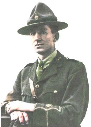
Garth Falloon carrying out daylight star observations at Vanda Station in the Wright Valley with T2 Theodolite, 1987.
T3 theodolite observations with observing tent at Mount Jason, 1988-89.
Di 20 EDM measurements in the Wright Valley, 1988-89.
Recording features and data in field books. Transport early 1960s.
Garth Falloon carrying out daylight star observations at Vanda Station in the Wright Valley with T2 Theodolite, 1987.
T3 theodolite observations with observing tent at Mount Jason, 1988-89.
Di 20 EDM measurements in the Wright Valley, 1988-89.


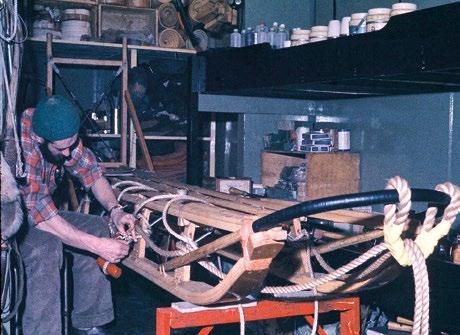
 Garth Falloon and Kelvin Tait doing survey work for the Cape Roberts tide gauge, 1990.
Programming a computer (under the blanket) at a TAMDEF GPS site.
Establishing a long-term TAMDEF GPS site. Solar power for running the receiver which is kept in a freezer. Freezers are good insulators and, while they keep items cool in hot climates, they can also be used in reverse in cold climates – ie keep the warmth in and cold out.
Graeme Blick and Don Grant (former Surveyor-General) using GPS and working with USGS on the Trans-Antarctic deformation (TAMDEF) project to monitor deformation in the Trans- Antarctic Mountain area.
Garth Falloon and Kelvin Tait doing survey work for the Cape Roberts tide gauge, 1990.
Programming a computer (under the blanket) at a TAMDEF GPS site.
Establishing a long-term TAMDEF GPS site. Solar power for running the receiver which is kept in a freezer. Freezers are good insulators and, while they keep items cool in hot climates, they can also be used in reverse in cold climates – ie keep the warmth in and cold out.
Graeme Blick and Don Grant (former Surveyor-General) using GPS and working with USGS on the Trans-Antarctic deformation (TAMDEF) project to monitor deformation in the Trans- Antarctic Mountain area.


 2022 Transport – plus covid precautions.


 Undertaking a horizon profile survey and GNSS survey to assess suitability for a SouthPAN ground station.
Karl and Lyndon setting up a Trimble GNSS receiver to undertake Scott base tide gauge calibration.
Undertaking a horizon profile survey and GNSS survey to assess suitability for a SouthPAN ground station.
Karl and Lyndon setting up a Trimble GNSS receiver to undertake Scott base tide gauge calibration.


 Monitoring wind turbines with Leica LS15 Digital Level. Dave Collett with the new sea floor mount for the Scott Base tide gauge.
It was with great excitement that Survey and Spatial New Zealand (S+SNZ) announced the official launch of the long-awaited Survey and Spatial New Zealand Certification Framework. This achievement is the result of a 2-year Certification Development Project, including a successful Pilot Program that was completed in 2022.

The purpose of the new framework is to provide a recognised professional pathway for members at all levels, with clear eligibility criteria, a public register and mandatory Continuing Professional Development - all supported by a robust renewal process and a quality management system.
S+SNZ anticipate accepting applications from July 2023 for the two certifications that will be on offer. These are the Survey and Spatial New Zealand Certified Professional Engineering Surveyor and the Survey and Spatial New Zealand Certified Professional Land Development Engineer. There is an immense amount of interest in the framework as the two certifications will be the first of their kind in New Zealand and will set a quality benchmark for the industry. The programme will be open exclusively to S+SNZ members who can expect an announcement with detailed information on the cost and process of application prior to the opening of applications.
Under the new framework we will initially provide Certification for Engineering Surveyors and Land Development Engineers. Over time, it is expected that the framework will be expanded to include other professions within S+SNZ membership.
Engineering Surveying was chosen as it an unregulated industry within in New Zealand and this new certification is the first step to providing recognition of professional and technical competency for NZ Engineering Surveyors. It will provide quality assurance for employers, clients, and third parties and provide a new career pathway for our members.
Photo provided by Carl Salmons, Director of Maven and one of the certification programme’s Land Development Engineering Assessors.There is an immense amount of interest in the framework as the two certifications will be the first of their kind in New Zealand and will set a quality benchmark for the industry.
Land Development Engineering was the second choice and is a first in New Zealand for Professional Land Development Engineers. The framework assesses to a high standard, providing recognition of current professional and technical competency in civil engineering as it relates to land development. It also aligns with the intent of Ministry of Business, Innovation & Employment’s new ‘Occupational Regulation of Engineers’ Act which is due to be passed in 2023.
The framework is designed to include processes that ensure currency. This will be achieved with a 4 yearly Re-assessment of Competency, an Annual Practising Certificate with compulsory Continuing Professional Development and an annual commitment to ethics and professional best practice.
The Certifications of Competence are formal recognition by S+SNZ of those who have been assessed against a defined set of professional and technical competencies. Theses meet standards and technical sign-off criteria required by private and public asset owners, Territorial and Local Authorities and other such entities.
There will be Annual Practising Certificates for both the Survey and Spatial New Zealand Certified Professional Engineering Surveyor and the Survey and Spatial New Zealand Professional Land Development Engineer setting a quality benchmark for the industry to maintain public confidence across key areas in which they practice.


Enquiries relating to the framework can be sent to certification@surveyspatialnz.org •


The launch of the new Certification Programme underway was the result of a successful pilot and proof of concept completed in 2022. Here we ask a few participants about the pilot and what it meant for them.

What was your role in the Certification Pilot? I was a candidate and I wanted to register as a professional. What were the results for you? It was quite a long process but at the end of the day I’m now a Certified Professional Engineering Surveyor. It was a positive outcome for me. It was quite nice to go through the process and see how the guys compare your skills and knowledge of the industry to what the industry expects from a professional surveyor. It was a thorough process; it was very good.
What was your role in the certification pilot? I was one of ten assessors. All the assessors were assessed as part of the pilot. We were assessed together and there were around 20 further candidates, across the two different certifications. I then assessed about ten candidates altogether ranging from assessing assessors (one of the two main interviewers) and a third observing interviewer.
What were the results for you?
I became a Certified Professional Engineering Surveyor (number one apparently). As an Assessor seeing the different results was very interesting, it was a lot more varied than I expected. Some people really knew their stuff and others didn’t. The overall results were that we didn’t pass at least half of the candidates, it was surprising that quite a few people weren’t up to our standard, I hoped there would be more but we have a high standard and we are quite strict and keen to maintain that and keep the standard high.
JAYNE ALBISTON
What was your role in the certification pilot? The Pilot Program was part of the ‘Build’ phase of the Certification Framework Development Project, that I have led in my capacity as Professional Development & Advocacy Manager, with the oversight of a Governance Committee appointed by Survey and Spatial NZ Council.
Midway through 2020, I was brought on to the National Team at Survey and Spatial, to carry out a series of reviews, which resulted in a proposal for a new Certification Framework. I began Phase 1 of the project in 2021 by designing the Framework, complete with an assessment process suitable for all practice areas within the professions represented by Survey and Spatial NZ.
The 2020 reviews had revealed a common set of criteria across employers, regional and local authorities and the public for the definition of a ‘suitably qualified and experienced professional’. Those criteria, along with key organisational goals for Survey and Spatial New Zealand, became the benchmark for the new framework. They were also embedded into the design of the processes for the professional and technical assessments, recognition of competency and maintaining it on an on-going basis. In short, the Framework and programs inside it, had to include clear eligibility criteria, a public register, mandatory CPD and be supported by a robust renewal process and quality management system.
The two professions selected by Survey and Spatial for development of certification within the new framework were Engineering Survey and Land Development Engineering. Once I had designed the framework and processes, I worked with the Stream Leadership from Engineering Surveying and Land Development
Engineering to develop sets of professional and technical competencies. We designed one set of professional competencies for both certifications, the difference being that it would be assessed relevant to the profession for which competency was being applied for. Both certifications had their own sets of technical competencies.
The outcome of the design phase was a common purpose for all certifications developed for the framework; they would be formal recognition by Survey and Spatial New Zealand of those who had been assessed against a defined set of professional and technical competencies, which met standards and technical sign off criteria required by Private and Public Asset Owners, Territorial and Local Authorities and other such Entities.
Halfway through 2021, MBIE came out with a proposed new regime for the ‘Occupational Regulation of Engineers’ which was all encompassing and included land development engineering. This gave the development of our land development engineering certification an extra layer of purpose. After our submission to MBIE, it became clear we would be working towards our Land Development Engineering Certification becoming a class of licence under the new regime once the new Bill was passed. (NB. The draft Bill is due to be published in 2023)
The ’Build’ phase of the Certification Development project involved building the physical assets required to test and pilot the process. Then along with Mike Cutfield from the Engineering Surveying Stream and others, we recruited 2 teams of Assessors for the Pilot Program. The first part of the Pilot Program, saw the Assessors being ‘candidates’ as they first had to apply for and be certified before they could then turn around and assess candidates.
Including the recruitment of the Assessor Team, the Pilot Program ran February – July 2022. The actual assessment was run over an intense 8-week period which saw us stretched to our limits as we worked to the goal of completing the Pilot prior to the 2022 Annual Conference, held in the first week of August. In total, there were 32 participants in the Pilot Program. It was a thorough and robust, successful Pilot, resulting in competent, Survey and Spatial New Zealand Certified Professional Engineering Surveyors and Land Development Engineers.
What were the results for you? There are many outcomes from the Pilot that I celebrate. The achievement of completing phase 2 of a multi-phase, long term project of national historical significance for the professions involved, is definitely a career highlight for me. The fact that until now, there has been no regulatory framework for Engineering Surveying as a profession in New Zealand and that we have stepped in to self-regulate in the absence of legislation, is massive. The fact that there has been no regulatory framework involving the on-going reassessment of competency for land development engineers and that we have now created one that aligns with the intent of MBIE’s new regime for the Occupational Regulation of Engineers, is a significant step towards preserving a highly valued practice area for surveyors and engineers alike.
Another highlight is that there are now two new career pathways for New Zealanders and Migrants from both university and vocational education backgrounds. For Survey and Spatial New Zealand, that creates new pathways into membership as the industry and professional ‘home’ for engineering surveyors and land development engineers.
The result in practical terms is that we are now moving to the Implementation Phase – which is a 5-year plan. As part of that, I am developing a National Stakeholder Engagement Strategy and Plan and will be a key player in facilitating that across New Zealand.
But the true gold from the Pilot Program for me, has been the creation of an exceptional National Team of Assessors, which we are continuing to build. The richness of relationships that this has created both personally and professionally for us all, cannot be understated. It is the people who made the Pilot Program and who will make the implementation of this National Framework and the Certifications that are developed within it.
SAM WILLIAMSassessments and supporting information to assess our general professional and technical competence. From there, we were assessed by a panel of our peers and if successful form part of the assessor team. Once we had put ourselves through the process, we were ready to assess the preliminary group of candidates to enable analysis of the data and the process of how the system was working. That has been my role to date.
Since then, Mike encouraged me to take up a position on Council with the Engineering Surveying Stream for S+SNZ. In that role my aim is to advocate for certification, continue building the engineering surveying stream, create a group and a leadership team in that space leveraging off the certification assessor team and working relationships generated in that space.
What were the results for you? It was quite daunting at first. Mike assembled quite a team of well recognised engineering surveyors.

What was your role in the certification pilot? I was asked by Mike Cutfield (the Engineering Stream Chair) at the time, to apply to be an assessor. This is something I have been passionate about for some time with the civil construction industry not being regulated in terms of the competency level of the surveyors who can work in our industry, so when Mike asked me to get involved, I was pretty keen. The aim is to set a quality benchmark for our industry.
Mike put us in contact with Jayne Albiston (S+SNZ Professional Development & Advocacy Manager) who got us all together and encouraged us to submit our applications, written

So, to have yourself tested against the competencies and the 1-hour panel assessment from your industry peers was a bit unnerving as to how much you really know and understand about surveying. In the end it was quite a rewarding process.
There were some tight time constraints in place to get everything through in time which put a bit of pressure on the team, but we managed. We pulled together, worked hard, worked long hours as a team and were able to get a sample data set out for the S+SNZ Board and Council to review. With the tireless efforts of Jayne, we have got the framework tidied up in terms of the wording, individual competencies, and refinement of different areas. I would like to think we have helped in getting the certification to where it is now – at a stage where it can be launched.
What was your role in the certification pilot? I was an assessor applicant to start with, after being invited in with a group of people who are established in the industry was the qualification. We went through the assessor applicant process, were interviewed by Zoom and if successful we were appointed to be assessors on the pilot programme (we were all successful, nobody failed).
We were then assessed and issued with a Certificate of Competency. Then our role involved into us assessing the initial pilot programme candidates and we independently assessed the candidates.
What were the results for you? There were five key things.
1. We became certified as competent to practise ourselves as approved Survey +Spatial NZ Engineering Surveyors in my case, others became Land Development Engineers. We will be issued with Annual Practicing Certificates, so it was a personal gain for each of us.
2. We will be appointed as assessors ongoing once the formal programme is rolled out from July 2023.
3. Bringing together and establishing the beginnings of a national network for Engineering Surveyors and Land Development Engineers in a community which has never really had a structural feel to it or a formality around its involvement with Survey and Spatial NZ or what was NZIS. That
Pictured above – Sam Williams, our Engineering Stream lead and assessor for the pilot Pictured above – Bruce Walker, lead of the S+SNZ Technicians Division and assessor for the pilotis a big gain, having a brand-new community coming out of it.
4. Other than the long established cadastral, hydro and more recently the spatial community where there were recognised academic qualifications, registration, certification to practise in specific areas it is really good to have this new formal recognition of that certification status within S+SNZ, particularly in more modern times. It reflects the global trend where surveyors are used not just in hydro, cadastral and spatial but certainly in construction and engineering it is such a massive part of our industry and our community has so many surveyors working in it that it is appropriate now to have the qualification that matches the new community represented globally and in New Zealand.


5. The final point is very special to me and many others in the industry, the

resurgence in interest and the ability to get the technicians division up and running with an enthusiasm possibly not felt since the old days of the NZTSA (the New Zealand Technician Surveyors Association) which ran from 1974 to about 1988. Many of the current S+SNZ members were part of the NZTSA and were from that community. We have really got in behind this neat resurgence feel with the technicians. The engineering surveying and land development engineering is a big part of that, but the whole technician community with people from cadastral and other fields, hopefully spatial and hydro (which is yet to be explored). The whole community has come together which has in effect been a really nice spin off. It has also led us to involvement with UNITEC and Toi Ohomai Institute of Technology and Te Pūkenga institutions who grabbed us and put
to talk to them as well. The whole certification programme has grown legs.
It has been superbly led by Jayne I have to say. We cannot claim to be the clever guys in this one, I think the Board and Council gave good direction, Ashley the CEO brought in a contractor (ie Jayne) who absolutely embraced this and with the support from National Office the outcomes with the educational institutions have delivered a spin off which I don’t think any of us thought would happen. It has been more than anyone could have hoped for as well as the Certification Programme. For me personally, we have kind of been waiting for this for over 40 years. A lot of people got a bit disillusioned along the way and many of us with a passion for the industry stuck it out. There have been swings of emotion all over the place so to

Roshni Sharma. Article republished from SheMaps.
Increased self-confidence and empathy in students are just some of ways to cultivate diversity benefits in school.
Diversity translates to significant increases in the bottom line, attracts top-level buy-in, and helps reach a broader customer base. It also strengthens trust in company culture, promotes better decision making and drives better innovation.
It’s all the rage.
The idea of leveraging diversity and inclusion isn’t a new one, but as well as the workplace, it’s just as useful to apply diversity in STEM (Science, Technology, Engineering and Mathematics education) and non-STEM schools.
So, how can we think about the
benefits of diversity and inclusion in the classroom? First, let’s consider what diversity and inclusion are really about.
Diversity refers to the differences in the makeup of a group, for example the mix of genders, racial backgrounds, nationalities, sexual orientations, etc.
Inclusion is a related and connected concept to diversity, which considers how well each of the various identity groups present are represented in the functioning of the group – are there equal levels of contribution, reward, presence and appreciation of

perspectives for all identities, or are some favoured?
Identity groups who are favoured or represented more are considered to be privileged, while those which are under-represented are considered to be minorities
Within the classroom, teachers can help to bring awareness of diversity and inclusion through the ways in which they guide class discussions and class content relating to people with identities of different kinds. They can also help the class to feel safe as a group, especially students who may fall into minority
groups, and set examples through the behaviours they model. Some of the benefits of this are as follows:
When students are exposed to various aspects of the world from an early age in a safe way, they can learn about people who are different as well as similar to them in an open-minded way. Learning about people from different cultures, different religious backgrounds, different types of families and different ways of thinking helps them to foster a deeper sense of safety and self-confidence when they come across these people in tertiary education and the workplace.
2.
Learning to relate to people in different ways, especially people who are different to us, helps foster empathy. Being able to consider the different circumstances and experiences that different groups of people experience helps students to become aware and appreciate some of the things they make take for granted. It may also help them to form stronger friendships, both at school and post-school.
As students build empathy, they are able to reduce their prejudices consciously, allowing them to form closer relationships with their peers. These interpersonal skills are valuable
not only to strengthen friendships, but will also be valuable skills which set them aside from others as they apply for jobs in the future.
4.
As students develop an appreciation for people who are both similar and different to them in different ways, building empathy and interpersonal skills, they become better equipped with the skills needed to improve their school performance. They are able to perform better in groups, better manage interpersonal conflicts if they arise in the schoolyard, assisting in managing emotions more effectively.
5.
Being exposed to different ways of thinking and being in the world helps broaden student’s minds to appreciate the depth and breadth of the world. This equips them to be better able to come up with new ideas, see different perspectives and to be open-minded.
Given the suite of benefits of diversity in STEM and non-STEM schools and workplaces, it makes sense to build an awareness and positive culture around it in classrooms.
Teachers are major role models to their students. So, they are in a unique position to offer gentle questioning when situations where diversity and inclusion matters arise. These could come up as part of discus-
sions around material being covered in class and different peer groups and individuals within the class. Sometimes the most impactful thing to do is to merely call attention to the fact that there are assumptions at play, and students will often respond positively to this increased awareness. Teachers can also weave curiosity about difference and STEM diversity into class content, helping to guide students gently to an awareness of the depth and breadth of types of people in the world.
You never know what sorts of academic or creativity benefits your students might come up with as a result!
Click here to read more about Unconscious Bias and How to Challenge it in the Classroom •

ABOUT THE AUTHOR:
Roshni is a Geospatial Scientist and Soft Skills Enthusiast, working to harness location intelligence to create tangible change for society. She loves dogs (but not cats) and reads copiously at every opportunity. Roshni strives to be a thought leader, a compassionate disruptor, a connector and someone who gets things done. Having traversed environmental science and management, human geography, palaeoclimatology and business, in her lifetime she want to help shift the culture of the geospatial industry to adopt new ways of thinking and technologies ethically to leverage location to change the way society conceptualises and enacts sustainability across all industries.
She Maps are one of Australia’s leading experts in drone and geospatial education. She Maps assist schools with the purchasing of drones, school-industry created drone and geospatial teaching resources and highly supportive teacher professional development.

Lyndon Telfer, Survey Product Manager for the Modernising Landonline programme at Toitū Te Whenua Land Information New Zealand, reports on the new Landonline – Survey application. He previously worked in the Office of the SurveyorGeneral and led the rollout of the Cadastral Survey Rules 2021.

The Landonline – Survey application is on track to provide endto-end survey capture functionality, following an 18-month pilot.
More than a third of all surveyors who use Landonline are now working in the new application – including students at Otago University’s School of Surveying – and Toitū Te Whenua is eager for more to get onboard before it becomes available to all Landonline users from April this year.
Developed in consultation with the Survey Working Group and surveyors to ensure that it’s fit for purpose, the new application has a modern look and feel, and is more intuitive.
The Survey Working Group is a reference group of surveyors from around Aotearoa New Zealand working with Toitū Te Whenua Land Information New Zealand to help inform the Modernising Landonline programme.
Importantly, the way customers enter information into the new application is similar to previously, but the process is easier and more efficient. Feedback from pilot users has been positive.
Our focus is to get more people using the new application before April to ensure there’s an experienced support network in survey firms to help, if needed.
It’s anticipated these users will become champions for new Landonline
within their firms. Firms already using the new application are encouraged to expand their number of users.
We’d also like to onboard users in firms who don’t currently use the new application but have indicated an interest to do so.
LINZ’s focus this year is to bring users onto the new application.
We’re confident from our pilot that the functionality we’ve delivered is ready, and that it’s right.
Users can capture survey datasets in the new application but will need to revert to Legacy Landonline to complete plan generation and sign and submit.
In April and May, we’ll be driving voluntary uptake as much as possible. We’ll then look at providing certainty on when migration to the new capture functionality must be achieved.
We’ll then review migration progress, and the steps required for full use of capture in the new application.
Completing the migration to the new application will enable us to focus on new Landonline enhancements for you.
Outside of the functionality that’s accessed in new Landonline, you’ll continue to work in Legacy Landonline on the same transaction, as the systems are fully compatible and integrated.
If you’d like to sign up or find out more, please email engagement@ linz.govt.nz •
Our focus is to get more people using the new application before April to ensure there’s an experienced support network in survey firms to help, if needed.


 Mick Strack
The issue of perpetual leases over Māori land is now being challenged by the Green Party in Parliament. They describe the arrangements as a thinly disguised system of land grab, and state:
“Māori landowners have had no direct say in who leased the land, what the rent should be, or what the land would be used for.” What are perpetual leases, why were they established and how do they work?
Prior to the Treaty of Waitangi, there was uncertainty about what Māori may have been selling; whether it was just a right to occupy the land alongside the customary owners such that the whānau or hapū retained control over the land and occupation was at the grace and favour of the chiefs. In any event, there was no English law established that could provide protection of any acquisition of land by settlers, and when Captain Hobson arrived in NSW in 1839 he declared all previous ‘purchases’ void, and then set up the Land Claims Commission to investigate those early land dealings, and to offer an English-style land grant to recognise legitimate and good faith purchases.
After the Treaty of Waitangi, when the Crown was busily acquiring Māori land for grant to the settlers, there was little debate about the required
property rights. A full fee simple title issued to an individual was seen as the only way to acquire complete and secure property rights; fee simple title provided security of tenure. However, by the last quarter of the 19th century, in an effort to get more settlers established on small holdings, the government wanted to provide additional incentives for farmers to settle on the land. Various forms of leases and grazing licences were tried and then perpetual leases were created by the Land Act 1882 for a 30-year period with a further 20-year right of renewal.
While most of these leases were created over Crown Land, many were created over land that the Crown had reserved for Māori, or were parcels returned to Māori after the confiscations of the 1860s. It was presumably thought that by creating a lease over Māori land, then Māori would retain some control over the land, retain some property rights, some decision-making ability, some regular income, and the possibility of resuming the land in a reasonably near future. But in fact, they were a device to further remove Māori control over the land.
A perpetual lease is usually established as a lease for 21 years with a regular review and right of renewal after that time. Typically, there is an annual rental fee of 5% of the land value (capital value less the value of
improvements). There are several benefits to leaseholders in such arrangements: purchase prices of the lease should be significantly less than a purchase of a fee simple estate; the relatively low annual rent should still allow for a reasonable profit to be made from production off the land; the leases including the improvements can be sold at a good profit; commitment to the land can be temporary. On the other hand, some restrictions come with these leases: the lessor can impose conditions on land use, there may be responsibilities and expectations to keep the land weed and pest free; and initially, for leases from the Crown, there was a requirement to clear the bush and drain the swamps – i.e. alter the land significantly for its productive values rather than retain the land’s natural values.
It was previously supposed that retention of Māori land may be effected by creating marketable leases rather than selling the fee simple title. However, when these leases were made perpetually renewable, any practical interest that Māori may have in the land was lost as the lessees acquired an almost complete property right. These perpetual leases amount to a complete loss of Māori control over this land – just one more way to undermine Māori interests in the land. Now many perpetual leases of Māori land are held and managed by the Office of the Māori Trustee.
The Māori Trustee position was first established in 1920 as the role of the Native Land Court was changing from alienation to better management of Māori land. The trustee’s purpose was to assist Māori in managing their
land for productive purposes. Later, in the 1950s, the Māori Trustee was empowered to acquire small and uneconomic parcels and shares in Māori land, again to assist with better management.
Under the current arrangements, with no prospect of Māori being able to realise the economic value of this land, nor of being able to restore their customary relationships with the land, the land provides minimal benefit for Māori. The Crown has demonstrated that legislation can be passed to extinguish perpetual leases, and the Crown has been relatively active in restoring Crown land to Māori through the Waitangi Tribunal processes, so it seems that dealing with these leases would provide some very useful benefits for iwi.
The Crown pastoral leases of the South Island High Country suitably illustrate the attributes of land use restriction and the values held in a lease. The

These perpetual leases amount to a complete loss of Māori control over this land – just one more way to undermine Māori interests in the land.
pastoral lessees are restricted in their land use (to grazing sheep and cattle), but recently as the Crown bought out these leases, very high purchase prices were paid by the Crown to extinguish the lease and regain the land as public conservation estate.
As an indication of the property rights attaching to a lease, a case was brought against a High Country station (Crown Lands v Minaret Station 2009). The case was largely about the rental valuation but there was also discussion about the nature of the property right in a perpetual lease. The court stated: “Those rights approximate those of the owner of the full bundle of property rights associated with ownership of the fee simple estate except for a requirement to pay rent and the imposition of restrictions on activities that may be undertaken on the land” (Minaret at [96]). And in another case brought to question the property rights of a Pastoral lease, the judge stated: “The very purpose of these leases is to alienate the land from the Crown, but in circumstances that limit the type of activity that may be carried out on the land” (NZ Fish & Game Council v AG 2009 at [82]).
The process of extinguishing the leases and/or converting the lease to freehold required a special act of Parliament (the Crown Pastoral Lands Act 1998), and considerable administration costs in assessing the land values,

negotiating with stakeholders, surveying the parcels, and registering new interests. That process was flawed in numerous ways, and subject to much criticism; especially with the interference by the Crown of legitimate property rights, and the subsequent generosity of the Crown to the affected lessees – the very high purchase prices.
The registered property rights of a perpetual lease have significant protections in law, so the extinguishment of these leases over Māori land will need legislative support. The regular rent and conditions reviews provide an appropriate time to negotiate the extinguishment of the right of renewal. This would give lessees appropriate notice about the removal of their property rights and time to negotiate exit conditions (including compensation for improvements).
The perpetual leases over Māori land amount to 26,000 hectares – only 0.1% of the land area of Aotearoa. It would seem that more serious issues attach to most Māori freehold land (about 5% of the country). These issues include the difficulties of land use decisions on multiply owned land that affect production, occupation, and cultural relationships. The process of repealing or amending Te Ture Whenua Māori Act 1993 has stalled, but much could be gained by addressing the problems of Māori land use and management in new legislation. •


Don McKay, FNZIS, has clearly chosen as his retirement job the recording of the life of one of the most illustrious and important surveyors New Zealand has ever had – Archie Bogle. Don was
not satisfied that such an important figure was marked only by an Institute award named after him and an anecdotal autobiography Bogle wrote over 50 years ago – Links in the Chain. Don had earlier penned an ‘article’ entitled Surveyor Extraordinaire which was a short biography in which he traced Archie’s career and achievements in the many positions he held.
I reviewed that article and expressed my concern as to what its future was as it was too short for a book and too long to be printed in an
pages on good quality paper. It is broken into the three parts covering the above 3 aspects plus introductions and prefaces, a bibliography, a glossary of terms and an index. The book has many photographs that were originally black and white but many have now been coloured which enhances them considerably and adds to the feeling of quality in the book. There is also a useful map of the Whanganui River basin where Archie undertook the majority of his work.
A great majority of the text is made up Archie’s writings, he was a very good and prolific writer and cover a multitude of subjects. His writing style is easy; it can sometimes be
light-hearted, sometime serious and sometime thoughtful (his 1935 Anzac address at Maxwell, p189, is a case in point). Through these writings and anecdotes we really do get the measure of the man. Don and his team have certainly achieved what they set out to do and should be congratulated for that. They obviously had a huge number of decisions to make in producing this book, I am not sure they got them all right but that does not distract from the overall attractiveness and readability of the book. This book will be a must for those who have not only an interest in the history of New Zealand surveying and surveyors but also the country’s early history. I can thoroughly recommend it. Any proceeds from the book will be going to the Kairūri Community Trust which was established by the Institute in 2017.
The Measure of the Man
Compiled by Don MacKay, Andrew Blackman, Gordon Andreassend
ISBN 978-0-473-66132-8
Book Production – PressGang

This is a book with its own Mana, a quality hardcover production in full colour, well-illustrated, elegant size (a little less than A4), very suitable for a coffee table/reception table and a great read. A book that will enhance our profession and the Institute and likely become a collectors’ item.
A book that has everything: part autobiographic, part biographic and part anecdotal, clearly illustrating why this man was undoubtedly surveyor of the century. The Foreword to this second enlarged edition is written by Bill Robertson.
During his career Archie carried out several unusual or notable jobs. Some of these are mentioned by Archie in Part One, some in Part Two. They varied dramatically from a magnetic survey of the North Island to bridge building to land developing and probably his last large job, the fourmonth contract to the Samoan government at the age of 73. We detail four of these jobs.
This book is dedicated to Archie, a tribute to his memory as one of our greatest sons on the occasion of the 50th anniversary of his death.
It is attractively priced for S+SNZ members at substantially less than retail and supports the Institute charitable arm, The Kairūri Community Trust.
The Bogle Reprint Committee and Editors Gordon Andreassend, Andrew Blackman and Don McKay.
If you wish to purchase a copy or copies and are a NZ resident NZIS member please go to our website www.surveyspatialnz. org and complete the order form.


1. The cost is $40 per copy inc GST plus P&P and credit card fee, at cost, $12. Delivered by courier in a protected envelope.
2. If you are a donor to the Trust as a result of earlier appeals, please ignore this invitation (unless you want further copies). Your complimentary copy is already reserved.
3. If you would like to purchase in bulk, boxes of 12 at a discounted price of $380 each plus GST and delivery please email Andrew andyblackman17@gmail.com
4. This invitation applies to NZ resident members. For those overseas members please email Andrew as above (unless you have already donated as above). Postage varies considerably country to country.
5. The GST amount on each purchase of $52 – is $6.61, and delivery April 2023.
NIWA
Rip currents are narrow, fast-moving segments of water that travel away from the shore. They can reach speeds of 2.5 metres per second, which is quicker than the fastest Olympic swimmer.
NIWA and Surf Life Saving New Zealand (SLSNZ) have developed a state-of-the-art rip current identification tool using artificial intelligence (AI) and deep learning. The tool showed around 90% accuracy detecting rip currents in videos and images in trials. The work is published in the journal Remote Sensing


NIWA coastal scientists Dr Christo Rautenbach and Neelesh Rampal say the technology has been tested on a
large variety of images from different coastal settings and they hope will ultimately be used by beachgoers to alert them of rip currents.
“We hope that by using cameras and drones at beaches, the tool will be able to scan video footage and notify people of the presence of rip currents. Even knowledgeable surf lifeguards can struggle identifying rips, depending on the beach and environmental conditions. As well as this, some beaches are remote or really large, so surf lifeguards can use all the extra help they can get!” said Dr Rautenbach.
The technology was developed by feeding millions
of coastal aerial images into the AI model, along with artificial rain and fog data, to teach it to identify where rips occur in real-time, regardless of weather conditions and camera angle.
The “warmer” colours are where the AI is focusing – it gives a probability score that shows, with various confidence, that a potentially deadly rip current is in that area. [NIWA]
Adam Wooler, Special Projects Manager at SLSNZ, says once operationalised the technology will be invaluable for people while they’re out enjoying our beautiful coastline.
“This is only the beginning of our research together and our goal is to build even more effective, accurate and reliable safety tools for New Zealand beaches. Rip currents can sweep even the strongest swimmers out to sea – we had 90 people sadly drown in New Zealand last year, 25 of them on beaches, so we’re hoping that this technology helps to significantly reduce that number,” said Wooler.
Rip currents are reported as the most hazardous safety risk to beachgoers around the world. An Australian study published in 2013 revealed that they have killed more people on Australian territory than bushfires, floods, cyclones, and shark attacks combined.
Stuart Caie, Chair, Hydrographic Stream Ocean Infinity (OI) is busy gearing up for the next phase of the HS73 and HS74 Hydrographic Survey, in the Tasman and Western Marlborough Sounds region.

This survey follows on from the previous 2022 survey in the same region, but it will shift focus to the offshore areas of the survey, approximately 12,000 nautical miles. This includes Farewell Spit to Kahurangi Shoals (West Coast, near Karamea), approaches to Nelson and near D’Urville Island.
This survey will be unique in that OI will be deploying two 8m uncrewed survey vessels (USV) called DriX, which will work as a force multiplier to the mothership (Seaworker). Whilst the DriX has previously been used in New Zealand and the Pacific on previous surveys, it will be the first time globally that two will operate simultaneously on a project of this scale.
All three survey vessels will share near identical setups and installations featuring Kongsberg EM2040 multibeam echo-sounders to obtain full 3D bathymetric coverage, backscatter and water column data in several locations around the region. OI, which will be based out of Nelson, hopes to begin operations in late April and complete them in July.

Classes are back at Otago University, and two optional hydrographic surveying papers are offered for 2023. There are healthy class numbers and the students are looking forward to getting on the water in a few weeks.
Discovery Marine Limited (DML) has completed data capture for the Approaches to Napier Hydrographic Survey and Phase 1 data capture of the Approaches to Gisborne
The survey will be the first time the two DriX vessels will work simultaneously on a project of this scale.Hydrographic Survey. DML mobilised a 23m vessel, Tranquil Image, for 24-hour multibeam echosounder survey operations in both regions between September and December 2022.
DML was sad to say goodbye to its summer intern Ella Westenberg in February. Ella joined DML in November and quickly became part of the team, getting involved with all aspects of life at DML. Ella plans to use her experience with processing acoustic backscatter at DML to help her achieve honours in marine science from the University of Otago in 2023.
In January DML hosted the inaugural recipients of the DML, OI and LINZ co-sponsored Women in Hydrography experience. Eliza McCracken from the University of Canterbury and Sophie Clayton from the University of Otago joined the DML team, getting a taste of what life is like at a hydrographic surveying company.
Their experience included time onboard DML’s survey vessel Tupaia undertaking surveys for the Port of Tauranga. DML thanks Eliza and Sophie for their enthusiasm and interest in the hydrographic surveying industry.
Will Fraser from Mount Maunganui College was awarded the Year 13 DML Earth, Environment and Spatial Sciences Scholarship for 2022. The scholarship recognises Will’s passion for practical science and will help him with his transition to the University of Canterbury in 2023. DML is proud to support Mount Maunganui College with the scholarship, now in its fifth year.
DML is busy providing support to our port clients after the devastating impacts of Cyclone Gabrielle. In the space of a week, DML has mobilised survey teams and vessels to Port
of Tauranga, Port of Napier and Northport for emergency survey work to ensure the ports and critical supply chains remain open.
The 20th South West Pacific Hydrographic Commission (SWPHC20) meeting was held on February 22-24 in Wellington, hosted by Toitū Te Whenua Land Information New Zealand, which has chaired the commission for the past three years.

This was the first time delegates had gathered in person since 2020, bringing people from around the Pacific. The meeting was attended (in person and online) by 80 representatives from 15 nations, regional organisations and international intergovernmental organisations.
The meeting was preceded by an International Hydrographic Organization (IHO) funded capacity building two-day workshop on hydrographic governance, attended by 30 delegates from Pacific Island countries, hydrographic offices, the IHO, and subject matter experts.
The purpose of the workshop was to review a high-level hydrographic governance gap analysis that provides foundational data relating to the status of national interest, national arrangements and external coordination. The output was an action plan for each country to bridge the gaps.
Antoni Moore, an Associate Professor in Geographical Information Science, is the new Dean of the School of
Surveying at the University of Otago. Antoni takes over the role from Professor Christina Hulbe, who held the position for ten years. Antoni says Christina displayed exemplary leadership during her time as Dean, including curriculum changes and positioning the School as a Te Tiriti-led place of learning and research.
Antoni says he’s keen to give back to the School which includes exploring convergences and synergies in the many different fields that surveying encompasses. He is also looking forward to engaging with Survey Spatial New Zealand and the profession as a whole in his new role.

His arrival also coincides with a change in the curriculum for students commencing their degrees in 2023, including two new first-year papers. “These changes reflect surveying in the 2020s, bringing together the many different fields that the School covers, from geospatial science – GIS and remote sensing – to land planning and development as well as surveying measurement. All these areas can be applied to societal challenges and opportunities, including the critical issues facing us today, such as climate change.”
Antoni transferred to the School in 2008 following seven years in the Department of Information Science. As well as his long-standing research interests in geographic visualisation and cartography, he is a lead principal investigator on a Royal Society Marsden funded project (Strand) that’s exploring climate change related flooding hazards and impacts on coastal property values. He is also currently the president of the New Zealand Cartographic Society.


In March, a newly refreshed Survey and Spatial NZ website was launched.
Ashley Church, CE says “He was delighted to present the new site with a fresh, clean look to members. With the last major upgrade in 2017, it was very timely.
“Work on the refresh started in the latter part of 2022 when Cyberglue, our website and member database provider, introduced new functionality allowing much greater flexibility with the layout design and content management. The last major upgrade was a while ago so we’re delighted to finally deliver this new version to members.”
You’ll notice some changes and new features. There is a new member’s Dashboard layout and new member directory and profile layouts for both companies and members to use for marketing purposes. The simplified menu tabs make it easier to navigate around the site.
With making communication easier for everyone in mind, we have introduced another new feature – a members’ Tipline to keep in touch. The Tipline will not only be on every webpage but also in all our email templates.
 Claire Tyler, Rainey Collins Lawyers
An investor owned an apartment in a complex of 4 unit titled apartments, which they contacted a real estate agent about selling. The agent asked them for contact details and information about the Body Corporate, including levies and insurance.
The investor was adamant that because their complex was a small complex, and had a ‘non-functioning Body Corporate’, any disclosure rules did not apply to them when it came to selling their unit.
The agent wasn’t sure what exactly was required in terms of disclosure when there is no ‘functioning’ Body Corporate, so sought legal advice.
The legal position here is clear. There is no such thing legally as ‘non-functioning Body Corporate’, and all the same disclosure rules apply to smaller Bodies Corporate as larger ones.
All unit titled properties, no matter how small or large the development is, are governed by the Unit Titles Act 2010. All unit owners in a unit titled development make up the Body Corporate.
The key things, as an absolute minimum, that a Body Corporate should do is:
1. Maintain a register of all unit owners;
2. Have an operating account into which levies are paid (which at the very least, should cover insurance costs);
3. Ensure the development is insured under one insurance policy (noting there is an exception if units are not attached to each other, where the Body Corporate can insure separately if it passes a special resolution confirming this);
4. Manage and maintain common property;
5. Have a Long Term Maintenance Plan in place; and
6. Provide disclosure statements when a unit owner is selling their property.
The only thing that a smaller Body Corporate is exempt from under the Act is the requirement to have a Body Corporate committee. A committee is a smaller group of owners which the Body Corporate has delegated certain responsibilities to.
Any Body Corporate with 9 or fewer units does not need to have a Body Corporate committee.
If there is no committee or no nominated chairperson of the Body Corporate, then all owners need to sign all documents on behalf of a Body Corporate.
When selling a unit titled property there are requirements under the Act for the Vendor to provide the Purchaser with:
A Pre-Contract Disclosure Statement,
A Pre-Settlement Disclosure Statement,
Insurance details, and
An additional disclosure statement, if requested by the Purchaser.
It is important to be aware that this disclosure regime is separate from any more general disclosures that real estate agents will require when listing a property.
Vendors still need to disclose to their real estate agents any known defects, and the agent is required to point out any defects or likely defects that they should know in their experience as an agent.
When selling the property the Vendor needs to provide (and sign) a Pre-Contract Disclosure Statement to purchasers. There is a template statement on the Tenancy Services website, which may assist if the Body Corporate does not know how to prepare the statement.
There is a specific list of items that need to be included in the statement, as detailed in the Unit Titles Regulations.
The Vendor is required to provide the Purchaser with a certificate of insurance and a Pre-Settlement Disclosure Statement no later than five working days before settlement.
A Pre-Settlement Disclosure Statement is also signed by the Vendor, but is required to be accompanied by a certificate from the Body Corporate confirming the contents of it are correct. If there is no chairperson or committee, this statement will need to be signed by all owners.
It could be difficult to get all owners to sign, so enquiries
(continued page 44)
In the 60th year of the School of Surveying, it would seem an appropriate time to reflect on surveying education; then and now. Over the course of those years, the school has changed significantly – it has grown in student and staff size, it has moved building twice, its curriculum has evolved and the school can now proudly count over 2000 surveying graduates.
Surveying has been taught at University of Otago since the 1880s when papers in surveying were offered as part of the degree in mining courses offered by the Otago School of Mines. It was from this mining department that the School of Surveying grew thanks to the hard work of Professor John Mackie and other prominent NZIS stalwarts of that time, including Archie Bogle and others.
The autobiography of John Mackie provides an interesting chapter on the creation of the current School of Surveying, and in it, he describes the benefit of acquiring new equipment to improve teaching – a number of plane tables. In a similar vein, the school has recently enjoyed a
new influx of total stations and robotic equipment, greatly enhancing student learning in the 2020s. Many things have obviously changed since those early days – instruments, computing, survey methods but some things remain the same. In the 1960s, survey camps were held at Tirohanga, a small Bible Class hall in the hills behind Mosgiel. In Prof Mackie’s words, running the camp “involved administration resembling an army exercise”. I’m sure my camp colleagues’ would heartily agree with those comments in 2023, after catering for our biggest student cohort ever taken away to camp this year – 74 students.
Ironically, as I have written about in a previous article, our new camp at Orangapai in the Maniatoto is also a Bible or Christian camp. No doubt out of respect for the ethos of his Taieri camp, Mackie and his students “would all call into one of the Mosgiel pubs on the way back to Tirohanga”, whereas at Orangapai we pack out the Waipiata pub for our last evening at camp.
In 1973 Joanne Waugh became the first female student to enrol at
the school, completing a surveying diploma. Around this time the school was considering the adoption of a four-year degree course with the first intake in 1976, and five years later, Vicky Nalder (former Chair of the CSLB) became the first female to graduate with the new BSurv degree.
The first pro camp of 2023 included 13 female students, an increase certainly, but our overall female class percentages continue to lag behind what we as an industry should aspire to. The staff numbers at the school are somewhat better with the department currently employing five female staff members across the 17 roles.
Some of this historical information comes from an S+SNZ Quarterly article written by Mark Smith in 2013 at the time of the 50th anniversary. In it he highlights the introduction of a new curriculum in 1994 which involved the introduction of first year papers undertaken at Otago. Previously students could do the intermediate year at any university in New Zealand with general maths and physics papers. I have fond memories of my intermediate year at Waikato University, before arriving at Survey
(continued bottom of page 44)

(continued from page 42)
may need to be made very early in the piece to avoid settlement potentially being delayed as mentioned below.
This Pre-Settlement Disclosure Statement includes information regarding the levies that will be apportioned on settlement, and other details relevant to the purchase.
It is worth noting that, under the Agreement for Sale and Purchase, only ordinary levies are apportioned on settlement, not Long Term Maintenance, Contingency or Capital Improvement fund levies. Vendors will not get back a share of what they have contributed to any such funds over time.
It is also important to be aware that the Agreement can be delayed or cancelled if this statement is not provided within 5 working days of settlement.

It is important to remember that when selling a unit titled property, the agent is required to hold the deposit until the Pre-Settlement Disclosure Statement and Additional Disclosure Statement (if requested) have been provided, as there is a right for the Purchaser to cancel prior to those statement being provided.
This Bill, currently passing through Parliament, seeks to update the Unit Titles Act and rectify some known problem areas. The Bill has passed its Third Reading and is expected to be considered again in May.
Key things that the Bill will change are:
Adding additional items to be provided under a Pre-Contract Disclosure Statement and some other changes to the disclosure regime;
Greater accountability for Body Corporate managers, who will be defined in the Act and will be subject to a code of conduct;
A reduction in the fees for applying to the Tenancy Tribunal in the event of a dispute;
Permanent ability to hold meetings via audio-visual link and vote electronically.
Sales of Unit Titled properties are more complex for all involved than fee simple sales, so it pays to know what to look out for and what is required, to avoid settlements being delayed or cancelled. •
(continued from page 43)
School camp to enjoy Ted Friel’s draughting instruction and Allan Blackie’s plumbing lessons at the Invermay Research farm.
This year we again introduce a new curriculum to the BSurv with new papers in that first intermediate year. As discussed in the last edition of this article, one of those new first year papers is SURV130: People, Place and the Built Environment. This paper aims to highlight the connection between people and land, provide students with an appreciation of Māori values to land, and introduce the main components of sustainability and climate change science – all very important topics in this age and in light of the recent damaging weather events in the North Island.
A better understanding of these issues, together with a change in the attitudes toward urban design
and the development of land has been reflected in the changes to the associated papers in the BSurv course over time. In Professor Lex McRae’s Subdivisional Design booklet of the 1980s, I found that it was recommended that “in general, all watercourses be piped in the design of a new subdivision”. This is something that has certainly changed in teaching with a much greater focus on ecology and the function of natural drainage systems, and an understanding of the aesthetic and cultural value of the natural environment in our neighbourhoods.
In Mark Smith’s article, he reminisced about the school’s single Vax computer located in the windowless room known as the ‘Black Hole’. The school now has two large computer suites with over 80 computers between them. The school enjoys great
support from a number of industry software suppliers and, because of this, students are familiar with and have the ability to become well versed in a number of typical survey computation and design processes. What all employers must accept however is that like all surveying theory taught at the school, students receive an introduction to a range of skills as part of course teaching objectives but with a limited amount of practice.
Like almost all teaching they require a graduate to spend more time repeating these skills in a continued real life practice for them to become individually competent. This partnership between undergraduate theory and postgraduate practice to achieve the desired level of expertise has certainly not changed from ‘then to now’. •


