160 bURWOOD rD, cONCORD bUSHELLS Factory REDEVELOPMENT aMENDED pLANNING pROPOSAL (PP2018/0004) May 2022
Prepared by:
Prepared for:
New Concord Developments Pty Ltd
LFA (Pacific) Pty Ltd. All rights reserved. This work is covered by copyright and cannot be reproduced or copied in any form or by any means without written permission of LFA (Pacific) Pty Ltd.
Project
160 Burwood Road, Concord Bushells Factory Redevelopment Amended Planning Proposal
Client
New Concord Development Pty Ltd
Project Status
Amended Planning Proposal (v5-1)
Project Director
Jason Duda
Checked by
JD
Issue Type
For Council
Rev
Version/Amendments
Issued To
Date
00
Draft
Rob McGuinness
26 July 2018
01
Final Draft - Work In Progress
Rob McGuinness
27 July 2018
02
Final
Rob McGuinness
30 July 2018
03
Amendment (version 2) in response to Council's feedback
CIPM
7 February 2019
04
Amendment (version 3) in response to CBLPP
Rob McGuinness
10 September 2019
05
Amendment (version 3) in response to CBLPP - minor wording
Rob McGuinness
11 September 2019
06
Amendment (version 4) in response to SECPP
Rob McGuinness
30 June 2020
07
Amendment (version 4-1) in response to Council comments
Canada Bay Council
3 July 2020
08
Amendment (version 4-2) in response to Council comments
Canada Bay Council
5 July 2020
09
Amendment (version 4-3) in response to Council comments
Canada Bay Council
7 July 2020
10
Amendment (version 5) in response to Gateway Determination conditions Amendment (version 5-1) in response to Gateway Determination conditions and Council feedback
Canada Bay Council
9 May 2022
Canada Bay Council
25 May 2022
11
Contents Executive Summary . . . . . . . . . . . . . . . . . . . . . . . . . . . . . . . . . . . . . . . . . . . . . . . . . . . . . . . . . . . . . 5 1.0 INTRODUCTION . . . . . . . . . . . . . . . . . . . . . . . . . . . . . . . . . . . . . . . . . . . . . . . . . . . . . . . . 11 1.1 Background . . . . . . . . . . . . . . . . . . . . . . . . . . . . . . . . . . . . . . . . . . . . . . . . . . . . . . . . . . . . . . . 12 1.2 Structure of the Report . . . . . . . . . . . . . . . . . . . . . . . . . . . . . . . . . . . . . . . . . . . . . . . . . . . . . 17 1.3 Supporting Documentation . . . . . . . . . . . . . . . . . . . . . . . . . . . . . . . . . . . . . . . . . . . . . . . . . 18 2.0 THE SITE . . . . . . . . . . . . . . . . . . . . . . . . . . . . . . . . . . . . . . . . . . . . . . . . . . . . . . . . . . . . . . 19 2.1 Site Location & Context . . . . . . . . . . . . . . . . . . . . . . . . . . . . . . . . . . . . . . . . . . . . . . . . . . . . 19 2.2 Site Description. . . . . . . . . . . . . . . . . . . . . . . . . . . . . . . . . . . . . . . . . . . . . . . . . . . . . . . . . . . . 20 2.3 Surrounding Development. . . . . . . . . . . . . . . . . . . . . . . . . . . . . . . . . . . . . . . . . . . . . . . . . . 22 3.0 PLANNING CONTEXT & FRAMEWORK . . . . . . . . . . . . . . . . . . . . . . . . . . . . . . . . . . . . . 23 3.1 Strategic Planning Context. . . . . . . . . . . . . . . . . . . . . . . . . . . . . . . . . . . . . . . . . . . . . . . . . . 23 3.2 Statutory Planning Framework . . . . . . . . . . . . . . . . . . . . . . . . . . . . . . . . . . . . . . . . . . . . . . 28 4.0 REQUEST FOR AMENDED PLANNING PROPOSAL . . . . . . . . . . . . . . . . . . . . . . . . . . . . 34 5.0 AMENDED PLANNING PROPOSAL . . . . . . . . . . . . . . . . . . . . . . . . . . . . . . . . . . . . . . . . 37 Part 1 – Objectives or Intended Outcomes . . . . . . . . . . . . . . . . . . . . . . . . . . . . . . . . . . . . . . . . 37 Part 2 – Explanation of the provisions that are to be amended. . . . . . . . . . . . . . . . . . . . . . . 48 Part 3 – Justification for the Objectives, Outcomes and the Process for Implementation 53 Part 4 – Mapping . . . . . . . . . . . . . . . . . . . . . . . . . . . . . . . . . . . . . . . . . . . . . . . . . . . . . . . . . . . . . . . 105 Part 5 – Community Consultation . . . . . . . . . . . . . . . . . . . . . . . . . . . . . . . . . . . . . . . . . . . . . . . . 105 Part 6 – Project Timeline. . . . . . . . . . . . . . . . . . . . . . . . . . . . . . . . . . . . . . . . . . . . . . . . . . . . . . . . . 107 6.0 CONCLUSION . . . . . . . . . . . . . . . . . . . . . . . . . . . . . . . . . . . . . . . . . . . . . . . . . . . . . . . . . . 108
i
Appendices APPENDIX A - SURVEY APPENDIX B – URBAN DESIGN REPORT APPENDIX C - CONCEPT PLAN, ANALYSIS AND SEPP 65 CERTIFICATION APPENDIX D – LANDSCAPE MASTER PLAN APPENDIX E – PUBLIC DOMAIN PLAN APPENDIX F – TRANSPORT IMPACT ASSESSMENT APPENDIX G - ABORICULTURAL DEVELOPMENT ASSESSMENT REPORT APPENDIX H – HERITAGE LISTING NOMINATION REPORT APPENDIX I – HERITAGE SIGNIFICANCE ASSESSMENT APPENDIX J – HERITAGE RESPONSE TO LOCAL PLANNING PANEL APPENDIX K – STATEMENT OF HERITAGE IMPACT APPENDIX L – FAÇADE REPORT APPENDIX M – DRAFT LETTER OF OFFER APPENDIX N - AFFORDABLE HOUSING CONTRIBUTIONS APPENDIX O - ECONOMIC IMPACT ASSESSMENT APPENDIX P - RETAIL DEMAND ASSESSMENT APPENDIX Q - ABORIGINAL HERITAGE DUE DILIGENCE ASSESSMENT APPENDIX R - PRELIMINARY SOIL CONTAMINATION ASSESSMENT APPENDIX S - ADDITIONAL CONTAMINATION ASSESSMENT APPENDIX T - PRELIMINARY GEOTECHNICAL INVESTIGATION APPENDIX U - ADDITIONAL GEOTECHNICAL INVESTIGATION APPENDIX V - SUSTAINABILITY STRATEGY APPENDIX W - SOCIAL INFRASTRUCTURE AND COMMUNITY USES DEMAND ASSESSMENT APPENDIX X - FLOOD ASSESSMENT REPORT APPENDIX Y - DETAILED SITE INVESTIGATION (ROUND 1)
ii
Figures Figure 1: Regional Context (Source: Urbis) . . . . . . . . . . . . . . . . . . . . . . . . . . . . . . . . . . . . . . . . . . . . 19 Figure 2: Site Lot and DP (Source: Urbis) . . . . . . . . . . . . . . . . . . . . . . . . . . . . . . . . . . . . . . . . . . . . . 20 Figure 3: Subject site and surrounds (Source: Urbis) . . . . . . . . . . . . . . . . . . . . . . . . . . . . . . . . . . . . 21 Figure 4: Existing Built Form (Source: Urbis/CIPM) . . . . . . . . . . . . . . . . . . . . . . . . . . . . . . . . . . . . . 21 Figure 5: LSPS Structure Plan . . . . . . . . . . . . . . . . . . . . . . . . . . . . . . . . . . . . . . . . . . . . . . . . . . . . . . . . 26 Figure 6: CBLEP 2013 Land Zoning Map . . . . . . . . . . . . . . . . . . . . . . . . . . . . . . . . . . . . . . . . . . . . . . 29 Figure 7: CBLEP2013 Floor Space Ratio Map . . . . . . . . . . . . . . . . . . . . . . . . . . . . . . . . . . . . . . . . . . 30 Figure 8: CBLEP2013 Height of Building Map . . . . . . . . . . . . . . . . . . . . . . . . . . . . . . . . . . . . . . . . . . 30 Figure 9: CBLEP2013 Heritage Map. . . . . . . . . . . . . . . . . . . . . . . . . . . . . . . . . . . . . . . . . . . . . . . . . . . 31 Figure 10: Design concept evolution (Roberts Day). . . . . . . . . . . . . . . . . . . . . . . . . . . . . . . . . . . . . . 38 Figure 11: Concept Plan (Source: Roberts Day /Occulus/ AJ+C/BVN) . . . . . . . . . . . . . . . . . . . . . . 38 Figure 12: Concept Plan - Potential Activities (Source: Roberts Day) . . . . . . . . . . . . . . . . . . . . . . . 39 Figure 13: Proposed Public Domain and private open space (Source AJ+C /BVN) . . . . . . . . . . 40 Figure 14: Access and Movement (Source: Roberts Day) . . . . . . . . . . . . . . . . . . . . . . . . . . . . . . . . . 41 Figure 15: Access and Movement (Source: Roberts Day) . . . . . . . . . . . . . . . . . . . . . . . . . . . . . . . . . 42 Figure 16: Urban Structure (Source: Roberts Day) . . . . . . . . . . . . . . . . . . . . . . . . . . . . . . . . . . . . . . . 43 Figure 17: Public Realm (Source: Roberts Day) . . . . . . . . . . . . . . . . . . . . . . . . . . . . . . . . . . . . . . . . . . 44 Figure 18: Open Space and Tree Retention (Source: Roberts Day) . . . . . . . . . . . . . . . . . . . . . . . . 45 Figure 19: Surrounding open space network (Source: Roberts Day) . . . . . . . . . . . . . . . . . . . . . . . 45 Figure 20: Transition of Building Heights (Source: Roberts Day) . . . . . . . . . . . . . . . . . . . . . . . . . . 46 Figure 21: Proposed Building Heights (Source: Roberts Day) . . . . . . . . . . . . . . . . . . . . . . . . . . . . . 46 Figure 22: Elevation 2 (Source: AJ+C/BVN) . . . . . . . . . . . . . . . . . . . . . . . . . . . . . . . . . . . . . . . . . . . . . 47 Figure 23: Site section 3 showing location of employment floorspace (blue) and residential (pink/ red) (Source: AJ+C/BVN) . . . . . . . . . . . . . . . . . . . . . . . . . . . . . . . . . . . . . . . . . . . . . . . . . . . 47 Figure 24: Proposed Land Zoning Map . . . . . . . . . . . . . . . . . . . . . . . . . . . . . . . . . . . . . . . . . . . . . . . . 49 Figure 25: Proposed Height of Building Map . . . . . . . . . . . . . . . . . . . . . . . . . . . . . . . . . . . . . . . . . . . 49 Figure 26: Proposed Floor Space Ratio Map . . . . . . . . . . . . . . . . . . . . . . . . . . . . . . . . . . . . . . . . . . . . 50 Figure 27: Proposed Heritage Map . . . . . . . . . . . . . . . . . . . . . . . . . . . . . . . . . . . . . . . . . . . . . . . . . . . . 50 Figure 28: Proposed Foreshore Building Line Map . . . . . . . . . . . . . . . . . . . . . . . . . . . . . . . . . . . . . . 51
iii
Tables Table 1:
IN1 General Industrial land zone controls. . . . . . . . . . . . . . . . . . . . . . . . . . . . . . . . . . . . . 28
Table 2:
Comparison of CBLEP 2013 provisions, original Planning Proposal, amended proposals in July 2018, February 2019, September 2019 and this amended Planning Proposal 35
Table 3:
Summary of Proposed Amendments to CBLEP 2013 . . . . . . . . . . . . . . . . . . . . . . . . . . . 48
Table 4:
Consistency with the Eastern City District Plan . . . . . . . . . . . . . . . . . . . . . . . . . . . . . . . . 63
Table 5:
Summary Strategic Merit Assessment . . . . . . . . . . . . . . . . . . . . . . . . . . . . . . . . . . . . . . . . 66
Table 6:
Consistency with Canada Bay Local Planning Strategy 2010-2031 . . . . . . . . . . . . . . . 67
Table 7:
Canada Bay Local Strategic Planning Statement . . . . . . . . . . . . . . . . . . . . . . . . . . . . . . . 69
Table 8:
Consistency with relevant SEPPs . . . . . . . . . . . . . . . . . . . . . . . . . . . . . . . . . . . . . . . . . . . . . 90
Table 9:
Consistency with relevant Section 9.1 Directions . . . . . . . . . . . . . . . . . . . . . . . . . . . . . . 91
iv
Executive Summary This Amended Planning Proposal for 160 Burwood Road, Concord has been prepared by LFA (Pacific) Pty Ltd for Colliers International Project Management on behalf of New Concord Developments Pty Ltd (the Proponent). The Proposal is for the rezoning of land together with amended planning controls under the Canada Bay Local Environmental Plan 2013 (CBLEP 2013). It seeks to enable the urban renewal of this existing industrial site into a revitalised neighbourhood foreshore development comprising residential, retail, commercial, community and recreational uses, together with the retention of compatible, low impact light industrial uses. This amended Planning Proposal has been prepared in response to the Gateway Determination conditions issued by the Department of Planning, Industry and Environment (DPIE)(Department Ref: PP_2021_6099) on 31 October 2021.
Amended Planning Proposal Specifically, this Amended Planning Proposal seeks to amend the CBLEP 2013 as follows: Rezone the subject site from the existing IN1 General Industrial land zone to part B1 Neighbourhood Centre, part R3 Medium Density Residential, part RE1 Public Recreation; Amend Part 6 Additional Local Planning Provisions to: – Apply the Foreshore Building Line to the portion of the site proposed to be zoned RE1 Public Recreation; and – Introduce a development standard for the site which sets out a minimum provision of 10,000m² GFA for non-residential uses, of which a minimum 3,000m² GFA shall be light industrial uses. Amend Schedule 1 Additional Permitted Uses to permit "Commercial premises" within the portion of the site proposed to be zoned R3 Medium Density Residential; Listing of the Former Bushells Factory Building as an item of Local Heritage in Schedule 5 Environmental Heritage; Increase the maximum height of buildings from 12m to a range of heights as follows: – 18m (5 storeys) to the northern boundary of the site; – RL 46.6 to reflect the existing roof height of the Central Roasting Hall building to be retained; – 21m (6 storeys) at the centre of the site around the Former Bushells Factory Central Roasting Hall building; – 15m (4 storeys with ground floor urban services) between the Central Roasting Hall building and the 3 storey terraces on Burwood Road; – 12m (3 storeys), 17m (5 storeys) and 21m (6 storeys) along the eastern boundary; and – No change to heights along Burwood Road frontage, the western boundary and immediately north of the Central Roasting Hall. Increase the maximum FSR applicable across the whole of the site from 1:1 to 1.25:1 in accordance with Sydney Eastern City Planning Panel determination, which, when broken down into the proposed blocks, corresponds to an FSR of 1.15:1, 1.85:1, 2.1:1, 2.2:1 and 3.05:1 for each of those blocks.
160 Burwood Road, Concord Bushells Redevelopment - Amended Planning Proposal v5-1 | LFA (Pacific) Pty Ltd
5
As part of this amended Planning Proposal, the Proponent is seeking to enter into a Voluntary Planning Agreement (VPA) that provides for the following public benefits: 5,900m² of land for public open space, including remediation (if required) and embellishment of that land, to be dedicated to Council upon completion of the development project; Restoration works to the seawall and additional waterfront edge landscaping to provide access to the water (estimate $2,100,000). These restoration works will be completed prior to the dedication of the land to Council for public open space.
Background New Concord Developments Pty Ltd (formerly Freshfood) has owned and operated the Bushells factory at 160 Burwood Road, Concord for almost two decades. However, the factory has reached the end of its useful life and will cease operations on the site within the next few years, with a lower scale operation to be located at an alternative site. Thus, an opportunity is presented to consider alternative future land uses on the site. Initiated in 2014, the Planning Proposal process has involved considerable consultation with Council as well as consultation with the community. A collaborative design process stemming from an initial design competition in 2015 was undertaken, culminating in the formal lodgement of the Planning Proposal in June 2017. The Planning Proposal has evolved in response to both Council and community feedback, with the submission of amended proposals in July 2018, February 2019, September 2019 and June 2020. The amended Planning Proposal dated September 2019 was the subject of a Rezoning Review by the Sydney Eastern City Planning Panel on 31 March 2020. The panel determined that the Planning Proposal should proceed to Gateway on the following conditions: 1. A local planning provision be introduced into the instrument for the site to allow light industrial (IN2) uses to be permissible on the site. This is in the absence of a definition in the standard instrument of "urban services” 2. A development standard be introduced into the instrument to increase the minimum provision of non-residential uses to 10,000m2, where a minimum 3,000m2 shall be provided for ‘urban services’ (aka light industrial uses) 3. Satisfactory arrangements be in place prior to the instrument being made to allow for, at least, the maintenance on the site of: – Minimum of 8,900m2 of Public Open Space – Minimum of 10% affordable housing to be provided in perpetuity 4. A DCP shall be prepared and exhibited concurrently with the planning proposal to include urban design criteria; increased setbacks relative to building/wall height adjacent to existing lower density residential uses; increased building separation; height distribution relative to boundaries; building mass distribution; deep soil landscaping; sustainability measures and heritage and curtilage. It is noted that the mechanism for the provision for affordable housing will be via the Affordable Housing Contribution Scheme at the Development Application stage and the preparation of a DCP will be undertaken by Council. Accordingly, this amended Planning Proposal relates more specifically to items 1 and 2 of the Sydney Eastern City Planning Panel's recommendations. The following table summarises the key changes from the original Planning Proposal to this amended Planning Proposal.
6
160 Burwood Road, Concord Bushells Redevelopment - Amended Planning Proposal v5-1 | LFA (Pacific) Pty Ltd
Canada Bay LEP 2013
Original Planning Proposal (June 2017)
Amended Planning Proposal (July 2018)
Amended Planning Proposal (Feb 2019)
Amended Planning Proposal (Sept 2019)
Amended Planning Proposal (June 2020)
Amended Planning Proposal (May 2022)
Land Use Zoning
B4 Mixed Use
B4 Mixed Use
B1 Neighbourhood Centre; R3 Medium Density Residential; and RE1 Public Recreation
B1 Neighbourhood Centre; R3 Medium Density Residential; and RE1 Public Recreation
B1 Neighbourhood Centre; R3 Medium Density Residential; and RE1 Public Recreation
B1 Neighbourhood Centre; R3 Medium Density Residential; and RE1 Public Recreation
Height of Building
121.5m
12m, 22m, 25m and 46m
12m, 16m, 21m, 24m and 30m. RL 46.6 to reflect existing roof height of Central Roasting Hall
12m, 15m, 17m, 18m, and 21m. RL 46.6 to reflect existing roof height of Central Roasting Hall
12m, 15m, 17m, 18m, and 21m. RL 46.6 to reflect existing roof height of Central Roasting Hall
12m, 15m, 17m, 18m, and 21m. RL 46.6 to reflect existing roof height of Central Roasting Hall
FSR
1.95:1
1.6:1
1.5:1
1.25:1
Whole site: 1.25:1 which, when broken down into the proposed blocks, corresponds to an FSR of 1.13:1, 1.81:1, 2.1:1, 2.4:1 and 2.74:1 for each of those blocks
Whole site: 1.25:1 which, when broken down into the proposed blocks, corresponds to an FSR of 1.15:1, 1.85:1, 2.1:1, 2.2:1 and 3.05:1 for each of those blocks
Additional Local Provision
No change.
No change.
No change.
No change.
Apply Foreshore Building Line (in the RE1 zone)
Apply Foreshore Building Line (in the RE1 zone)
Minimum 10,000m² GFA for nonresidential uses, of which a minimum 3,000m² GFA for light industrial uses
Minimum 10,000m² GFA for nonresidential uses, of which a minimum 3,000m² GFA for light industrial uses
Schedule 1 Additional Permitted Uses
Boat sheds, jetties, moorings, water recreation structures
Multi unit dwellings
Light Industries (in the R3 zone)
No change.
Commercial Premises (in the R3 zone)
Commercial Premises (in the R3 zone)
Schedule 5 Environmental Heritage
No change.
No change.
No change.
Former Bushells Factory Building
Former Bushells Factory Building
Former Bushells Factory Building
Objectives and Intended Outcome The objective of the Planning Proposal is to facilitate the urban renewal of this industrial site to become a mixed-use riverside village that offers a mix of land uses that are more suited and complimentary to the existing local area including residential, retail, commercial, community, recreational and urban service (light industry) uses.
160 Burwood Road, Concord Bushells Redevelopment - Amended Planning Proposal v5-1 | LFA (Pacific) Pty Ltd
7
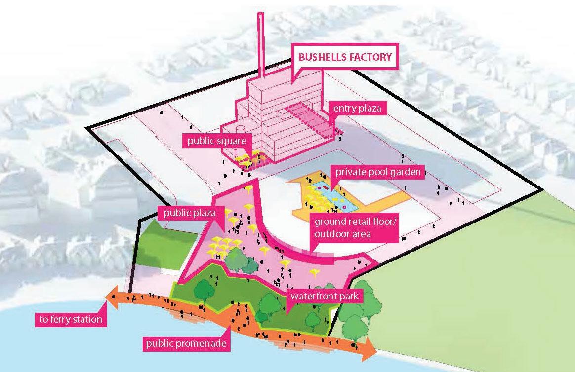
The intended outcome is the provision of approximately 400 new dwellings together with approximately 7,000m2 of retail / commercial uses and approximately 3,000m2 of light industry uses for the purposes of providing for urban services. The proposal will include new local roads and 5,900m2 of public open space including a foreshore park to Exile Bay, which will improve the permeability of the site for pedestrians, bicycles and vehicles. Built forms will range from 3 storeys (12m) to a maximum of 6 storeys (21m), focused around the retention and adaptive reuse of the Central Roasting Hall building (Former Bushell's Factory building), which is proposed for heritage listing in the CBLEP 2013 as part of this proposal.
Does the proposal have strategic merit? Consistency with the Greater Sydney Region Plan and / or Eastern City District Plan The proposal seeks to rezone industrial land to a mix of neighbourhood centre and medium density residential uses. However, both the Greater Sydney Region Plan (Objective 23 / Strategy 23.1) and the Eastern City District Plan (Action 51 / Planning Priority E12 Retain and Manage industrial and urban services land) set out to safeguard existing industrial land from redevelopment for residential and other uses to ensure adequate land is available for urban services, freight, logistics and advanced manufacturing. The continued suitability and appeal of the site for industrial use is constrained by the site's peninsular location, poor road access for heavy vehicles and adjacent sensitive residential uses. More broadly, the Inner West industrial market is characterised by low levels of demand and a shift away from traditional industrial uses. Accordingly, the outcomes sought by applying the 'retain and manage' principle would not be met if the site were to be retained entirely as an IN1 Industrial Zone. It is further noted that Council's strategic documents, the Canada Bay Local Planning Panel and the Sydney Eastern City Planning Panel acknowledge the limited suitability of the site for continued or intensified industrial land uses. Notwithstanding the above site suitability issues, the 'retain and manage' principle encourages a mix of economic outcomes that support the city and population. The Planning Proposal makes provision for light industry uses on the site that will enable a range of emerging 'urban services' to occur that support the local community and reflect the changing uses and character of employment lands in Eastern Sydney. On that basis, the 'retain and manage' principle could be achieved by the mix of uses proposed in the amended Planning Proposal. Consistency with a Relevant Local Strategy Council's Local Planning Strategy 2010-2031 (LPS 2031), which was endorsed by the NSW Department of Planning and Environment in 2009, specified the retention of the industrial zone on the subject site for term of ten years (i.e. to 2020) with redevelopment foreshadowed beyond this time frame. The directions and provisions of the LPS 2031 have been transferred to the Canada Bay Local Strategic Planning Statement (CBLSPS). The CBLSPS, which was granted formal assurance by the Greater Sydney Commission on 25 March 2020, acknowledges the site is likely to experience urban renewal in the short to medium term. It contains site specific requirements in Action 6.3, which sets out to ensure that any proposed changes to land use on the subject site adequately recognise the requirements of the Eastern City District Plan in relation to the retention and management of industrial land; achieve height and density that is compatible with the existing context; contributes to the Green Grid and adequately considers the site's heritage.
8
160 Burwood Road, Concord Bushells Redevelopment - Amended Planning Proposal v5-1 | LFA (Pacific) Pty Ltd
This amended Planning Proposal can achieve the outcomes identified in Action 6.3, as described above with respect to consistency with the Eastern City District Plan, together with the site specific matters discussed in the following section. Responding to a Change in Circumstance The Planning Proposal responds to a change in circumstances, given the planned cessation of manufacturing operations on the site due to declining viability, and the relocation of such operations elsewhere in NSW to better satisfy freight and logistic requirements. Given the site characteristics and surrounding residential uses, it is unlikely that another specialised manufacturing use nor mix of other industrial uses would be suited for the site or accepted by surrounding residents. Accordingly, there is a unique opportunity to introduce a mix of land uses that better complement the waterfront location and residential locality.
Does the proposal have site-specific merit? The subject site has a waterfront location and is surrounded by low to medium density residential development with good access to recreational open space. Thus, the proposal seeks to enable the renewal of the site to draw on its latent value as a river-side village, which is considered to be more complimentary to the existing neighbourhood than the current use. Additionally, the introduction of retail, commercial and community uses on the site will provide a level of containment such that residents of the peninsula will have a walkable alternative to Majors Bay Road Shops for meeting their day-to-day shopping and community needs. The amended Planning Proposal provides for an urban design framework that sets a context of the retention of the existing Former Bushells Factory Central Roasting Hall, Chimney and 'B' facade as a recognisable landmark in the locality whilst ensuring future development appropriately interfaces adjacent properties. The framework provides for greater permeability of the site with improved connections to the foreshore. Future development of the site in accordance with the amended Planning Proposal has been assessed and will not adversely impact local character and visual landscape, viability of nearby centres, adjacent heritage items, employment generation or traffic.
Justification As described above, the characteristics of the site are suited to the creation of a vibrant, neighbourhood-scale centre based on the mixed-use opportunities afforded by the adaptive re-use of the Central Roasting Hall as well as the waterfront amenity offered by the Parramatta River. This amended Planning Proposal responds to the recommendations made by the Sydney Eastern City Planning Panel in March 2020, in addition to the matters raised by the Canada Bay Local Planning Panel in June 2018. It reflects the evolution of a robust design process, consultation with the local community, an appreciation of the broader strategic direction of the Greater Sydney Region and Eastern Harbour City District, and aligns with Council's Local Planning Strategy and Local Strategic Planning Statement. Accordingly, favourable consideration is sought to progress this amended Planning Proposal for finalisation subject to public exhibition.
160 Burwood Road, Concord Bushells Redevelopment - Amended Planning Proposal v5-1 | LFA (Pacific) Pty Ltd
9
This page has been left intentionally blank
10
160 Burwood Road, Concord Bushells Redevelopment - Amended Planning Proposal v5-1 | LFA (Pacific) Pty Ltd
1.0 Introduction This Amended Planning Proposal for 160 Burwood Road, Concord has been prepared by LFA (Pacific) Pty Ltd for Colliers International Project Management on behalf of New Concord Developments Pty Ltd (the Proponent). The Proposal is for the rezoning of land together with amended planning controls under the Canada Bay Local Environmental Plan 2013 (CBLEP 2013). It seeks to enable the urban renewal of this existing industrial site into a revitalised neighbourhood foreshore development comprising residential, retail, commercial, community and recreational uses, together with the retention of compatible, low impact light industrial uses. This amended Planning Proposal has been prepared in response to the recommendations made by the Sydney Eastern City Planning Panel (SECPP) in its determination of the Rezoning Review on 31 March 2020 and the Gateway Determination conditions issued by the Department of Planning, Industry and Environment on 31 October 2021. Specifically, this Amended Planning Proposal seeks to amend the CBLEP 2013 as follows: Rezone the subject site from the existing IN1 General Industrial zone to part B1 Neighbourhood Centre, part R3 Medium Density Residential, part RE1 Public Recreation; Amend Part 6 Additional Local Planning Provisions to: – Apply the Foreshore Building Line to the portion of the site proposed to be zoned RE1 Public Recreation; and – Introduce a development standard for the site which sets out a minimum provision of 10,000m² GFA for non-residential uses, of which a minimum 3,000m² GFA shall be light industrial uses. Amend Schedule 1 Additional Permitted Uses to permit "Commercial premises" within the portion of the site proposed to be zoned R3 Medium Density Residential; Listing of the Former Bushells Factory Building as an item of Local Heritage in Schedule 5 Environmental Heritage; Increase the maximum height of buildings from 12m to a range of heights as follows: – 18m (5 storeys) to the northern boundary of the site; – RL 46.6 to reflect the existing roof height of the Central Roasting Hall building to be retained; – 21m (6 storeys) at the centre of the site around the Former Bushells Factory Central Roasting Hall building; – 15m (4 storeys with ground floor urban services) between the Central Roasting Hall building and the 3 storey terraces on Burwood Road; – 12m (3 storeys), 17m (5 storeys) and 21m (6 storeys) along the eastern boundary; and – No change to heights along Burwood Road frontage, the western boundary and immediately north of the Central Roasting Hall. Increase the maximum FSR applicable across the whole of the site from 1:1 to 1.25:1 in accordance with Sydney Eastern City Planning Panel determination, which, when broken down into the proposed blocks, corresponds to an FSR of 1.15:1, 1.85:1, 2.1:1, 2.2:1 and 3.05:1 for each of those blocks. As part of this amended Planning Proposal, the Proponent is seeking to enter into a Voluntary Planning Agreement (VPA) that provides for the following public benefits:
160 Burwood Road, Concord Bushells Redevelopment - Amended Planning Proposal v5-1 | LFA (Pacific) Pty Ltd
11
5,900m² of land for public open space, including embellishment of that land, to be dedicated to Council upon completion of the development project; Restoration works to the seawall and additional waterfront edge landscaping to provide access to the water (estimate $2,100,000). These restoration works will be completed prior to the dedication of the land to Council for public open space.
1.1 Background New Concord Developments Pty Ltd (formerly Freshfood) has owned and operated the Bushells factory at 160 Burwood Road, Concord for almost two decades. The factory has reached the end of its useful life and will cease operations on the site within the next few years, with a lower scale operation to be located at an alternative site. Thus an opportunity is presented to consider alternative future land uses on the site. The Planning Proposal process was initiated in 2014 with the engagement of the consultant team, preliminary discussions with Council regarding the future of the site, and an architectural design competition. In 2015, the Proponent and the consultant team engaged in consultation with City of Canada Bay Council, including one meeting, one workshop, two Councillor/Mayor briefings and one Councillor presentation to discuss the future of the site and potential design options. In 2016, further consultation was undertaken and in May of that year a Draft Planning Proposal was lodged. Following feedback from Council, the Draft Planning Proposal was provided to the then Department of Planning and Environment (DPE) who advised that height and density issues needed to be addressed. Original Planning Proposal – June 2017, Urbis In early 2017, the Proponent engaged in public consultation via a website and a public consultation day to understand the community’s desires for the site. The above culminated in the lodgement of a formal Planning Proposal in June 2017, which sought the following amendments to CBLEP 2013: Rezone the subject site from the existing IN1 General Industrial zone to B4 Mixed Use; Insert additional permitted uses for the subject site in Schedule 1 including ‘boat sheds’, ‘jetties’, ‘moorings’, and ‘water recreation structures’; Increase the height of building development standard from 12 metres to 121.5 metres; and Increase the maximum floor space ratio (FSR) development standard from 1:1 to 1.95:1. The above amendments to the controls were based on a scheme comprising five key buildings (including the existing factory Central Roasting Hall) as follows: 8 storey buildings on the eastern and western boundary; 25 storey tower fronting Burwood Road; and 37 storey tower fronting Zoeller Street. A draft Voluntary Planning Agreement (VPA) offer was submitted which outlined the following public benefits to be provided as part of the Planning Proposal: 10% of the proposed development of 683 units as affordable housing to be acquired and managed by a community housing provider at a 25% discount from the market price. Underwriting of a ferry service connecting Bayview Park Ferry Wharf and Barangaroo to a maximum of $700,000 per annum over three years (total $2,100,000). A signed heads of agreement between Freshfood (now New Concord Developments) and
12
160 Burwood Road, Concord Bushells Redevelopment - Amended Planning Proposal v5-1 | LFA (Pacific) Pty Ltd
Sealink Pty Ltd (which owns the Captain Cook cruises) to operate 14 ferry services daily between Bayview Park Ferry Wharf and Barangaroo immediately following completion of the first residential stage. The service would be 7 morning and 7 afternoon/evening peak services running every 20 to 25 minutes, 7 days a week. Provision of a bus service funded by Freshfood (now New Concord Developments) for a period of three years with an estimated cost of $280,000 per annum (total $840,000). The bus service would be an hourly service operating for a duration of 12 hours during the week and 8 hours on the weekend, connecting the site with Burwood and Strathfield stations via Concord Hospital. 18,900m2 of open space that whilst being retained in private ownership will be entirely publicly accessible and will effectively perform a public open space function. 2,769m2 of various community open space facilities offered to Council at a nominal rental for the use of community facilities. In addition, a 660sqm child care facility is identified with capacity for 90 children. Following an independent review process and Council review, Council recommended the Planning Proposal not be supported on the following basis: The proposal did not have strategic merit given the density proposed and its distance from a major centre and high frequency public transport; The proposal did not have site specific merit, given that the intensity of development proposed is inconsistent with the desired future local character on the locality; The proposed increase in built form scale and height could not be justified on the basis of retaining the existing factory building, which Council did not deem worthy of heritage listing; The proposed additional uses (i.e. man-made beach and marina-style jetty) was deemed inconsistent with the designation of Exile Bay for environmental protection and recognition that Sydney Harbour is to be protected for public good. Amended Planning Proposal (v1) – July 2018, LFA (Pacific) In July 2018, an amended Planning Proposal (v1) was submitted which sought to address the issues raised by Council, as follows: Deletion of proposed additional permitted uses on Exile Bay, including 'boat sheds’, ‘jetties’, ‘moorings’, and ‘water recreation structures’ Reduction and redistribution of proposed building heights across the site to respond more sympathetically to surrounding low density development, ranging from 12m up to a maximum of 46m (as per the existing roof height of the Central Roasting Hall) Reduction in proposed FSR from 1.95:1 to 1.6:1. A Draft VPA offer was also submitted that was similar to the initial offer, but with the omission of the rental offer for community and child care facilities. The proposal was again subject to an independent peer review process and Council review. In Council's letter dated 2 November 2018, it was acknowledged that the amended Planning Proposal represented a significant improvement from the previous application, however there were still a number of concerns regarding land use; urban design (building envelopes and height, floor space ratio, public domain, amenity, DCP); heritage; traffic and transport/access; landscaping; sustainability; and economic impact. A number of recommendations were made for an amended proposal. Amended Planning Proposal (v2) – February 2019, LFA (Pacific) In February 2019, an amended Planning Proposal (v2) was submitted which sought to address issues raised in Council's letter dated 2 November 2018, as follows:
160 Burwood Road, Concord Bushells Redevelopment - Amended Planning Proposal v5-1 | LFA (Pacific) Pty Ltd
13
Rezone the subject site from the existing IN1 General Industrial zone to part B1 Neighbourhood Centre, part R3 Medium Density Residential, part RE1 Public Recreation; Amend Schedule 1 Additional Permitted Uses to permit "Light industries" on the land to provide for low impact urban services; Listing of the Former Bushells Factory Building as an item of Local Heritage in Schedule 5 Environmental Heritage; Reduction and redistribution of proposed building heights across the site to respond more sympathetically to surrounding low density development, ranging from 12m up to a maximum of RL 46.4m (as per the existing roof height of the Central Roasting Hall) and nil height to the foreshore; and Reduction in proposed FSR from 1:6:1 to 1.5:1. A draft VPA offer was also submitted that was similar to the previous offer, but amended with the following: 10% of total dwellings with a 25% discount on the market rate, or cash equivalent, offered for the provision of Affordable Housing 7,400m2 of land to be dedicated to Council as public open space upon completion of the development project. The proposal was again subject to an independent peer review process (urban design, traffic, and economics) and was referred to City of Canada Bay Local Planning Panel (CBLPP) on 5 June 2019. The Panel’s recommendations were to: Reduce the proposed, scale and density of development. Identify the capacity of the site by understanding the traffic generated by the development and traffic management mitigations that need to be implemented including the opportunities and impacts of those initiatives. Identify how heritage influences the concept plan and provide a greater level of certainty around heritage outcomes. Ensure there is an appropriate framework for landscape outcomes including the retention in situ of T184. Prepare: – A site-specific Development Control Plan; and – An analysis of land levels, heights and relationships to existing and finished levels. Base any revised Planning Proposal and concept plan on fine grain, block by block FSR analysis. On 18 June 2019, Council considered the Panel’s recommendation and deferred the Planning Proposal subject to a Councillor workshop and consultation with community representatives. Amended Planning Proposal (v3) – September 2019, LFA (Pacific) In September 2019, an amended Planning Proposal (v3) was prepared specifically in response to the CBLPP's recommendations as follows: Rezone the subject site from the existing IN1 General Industrial zone to part B1 Neighbourhood Centre, part R3 Medium Density Residential, part RE1 Public Recreation; Listing of the Former Bushells Factory Building as an item of Local Heritage in Schedule 5 Environmental Heritage; Increase the maximum height of buildings from 12m to a range of heights as follows:
14
160 Burwood Road, Concord Bushells Redevelopment - Amended Planning Proposal v5-1 | LFA (Pacific) Pty Ltd
– 18m (5 storeys) to the northern boundary of the site; – RL 46.6 to reflect the existing roof height of the Central Roasting Hall building to be retained; – 21m (6 storeys) at the centre of the site around the Former Bushells Factory Central Roasting Hall building; – 15m (4 storeys with ground floor urban services) between the Central Roasting Hall building and the 3 storey terraces on Burwood Road; – 12m (3 storeys), 17m (5 storeys) and 21m (6 storeys) along the eastern boundary; and – No change to heights along Burwood Road frontage, the western boundary and immediately north of the Central Roasting Hall. Increase the maximum FSR applicable to the site from 1:1 to 1.25:1. The draft VPA offer was also amended and which offered the following public benefits: Minimum 5% of total dwellings, dedicated to an independent affordable housing provider for the provision of Affordable Housing; 8,900m2 of land to be dedicated to Council as public open space upon completion of the development project; Funding for the provision of a bus service for a period of three years with an estimated cost of $280,000 per annum (total $840,000); and Restoration works to the seawall and additional waterfront edge landscaping to provide access to the water (estimate $2,100,000). Agreement will be reached with the Roads and Maritime Service to confirm final scope of works) The funding of Protective Golf Nets to be installed on the Golf Course Lands behind the “Green” adjacent to the Zoeller St Reserve (estimate $200,000) The amended Planning Proposal was not accepted by Council as it had already commenced reporting on the previous (February 2019) version. On the basis that Council had failed to indicate its support within 90 days after the lodgement of the planning proposal, a rezoning review request was submitted to the NSW Department of Planning, Infrastructure and Environment (DPIE). Rezoning Review – March 2020 On September 25 2019, DPIE advised Council of the rezoning review request and on 17 March 2020, DPIE referred the matter to the Sydney Eastern City Planning Panel (SECPP). A Rezoning Review Meeting was held on 31 March 2020 with members of the SECPP, DPIE, Council and the Proponent representatives. The SECPP determined that the planning proposal demonstrated both strategic and sitespecific merit and should be submitted for a Gateway determination, subject to the following recommended conditions: 1. A local planning provision be introduced into the instrument for the site to allow light industrial (IN2) uses to be permissible on the site. This is in the absence of a definition in the standard instrument of ‘urban services” 2. A development standard be introduced into the instrument to increase the minimum provision of non-residential uses to 10,000m2, where a minimum 3,000m2 shall be provided for ‘urban services’ (aka light industrial uses) 3. Satisfactory arrangements be in place prior to the instrument being made to allow for, at least, the maintenance on the site of: – Minimum of 8,900m2 of Public Open Space
160 Burwood Road, Concord Bushells Redevelopment - Amended Planning Proposal v5-1 | LFA (Pacific) Pty Ltd
15
– Minimum of 10% affordable housing to be provided in perpetuity 4. A DCP shall be prepared and exhibited concurrently with the planning proposal to include urban design criteria; increased setbacks relative to building/wall height adjacent to existing lower density residential uses; increased building separation; height distribution relative to boundaries; building mass distribution; deep soil landscaping; sustainability measures and heritage and curtilage. It is noted that the mechanism for the provision for affordable housing will be via the Council Affordable Housing Contribution Scheme. Affordable Housing will be provided consistent with the requirements of SEPP 70 and Council's draft Affordable Housing Contribution Scheme to be updated to reflect the recommendations of the Eastern City Planning Panel. Gateway Determination – October 2021 In October 2021, a Gateway Determination was issued by the Department of Planning, Industry and Environment with the following conditions: 1.
Prior to public exhibition, the planning proposal is to be revised to address the following: a. Ministerial Direction 2.3 Heritage Conservation as it relates to the proposal and include the Aboriginal Due Diligence Assessment for public exhibition, subject to the redaction of any culturally sensitive information. b. Ministerial Direction 2.6 as it relates to the proposal and prepare a Detailed Site Investigation (DESI) to address the recommendations of report 13188/2, prepared by Geotechnique Pty Ltd. c. Ministerial Direction 4.3 Flooding by assessing the proposal against the requirements of the Direction. d. Demonstrate that future development is capable of achieving the minimum solar access requirements in the Apartment Design Guide (3D and 4A) to apartments and communal open space. e. Clarify the proposed FSR controls. The planning proposal is to include a FSR map showing the proposed site FSR, and a supporting plan showing the resulting block by block distribution of FSR across the site. f. Include provisions to ensure spatial needs of light industry uses are addressed, including requirements for light industry to be located on the lower and upper ground floor levels of the Central Roasting Hall, and appropriate floor-to-ceiling heights. g. Consolidated update of technical documentation, including but not limited to: i. update the Explanation of Provisions to acknowledge the need to amend Clause 6.12 Affordable Housing in the LEP in accordance with the Affordable Housing Contribution Scheme. ii. the draft DCP to address the spatial needs of light industrial uses as well as detailed design considerations such as floor to ceiling height spans, loading docks and vehicle access/parking, vehicle circulation, waste disposal, storage and service areas/ corridors, etc.
2.
Prior to finalisation, the planning proposal is to be revised to: a. Address the inconsistency with Ministerial Direction 6.3 to provide further justification that the inconsistency with Direction 6.3 is a minor inconsistency. b. Update the Transport Impact Assessment to reflect the current proposal and following consultation with Transport for NSW.
3. Public exhibition is required under section 3.34(2)(c) and schedule 1 clause 4 of the Act as follows: (a) the planning proposal must be made publicly available for a minimum of 28 days; and
16
160 Burwood Road, Concord Bushells Redevelopment - Amended Planning Proposal v5-1 | LFA (Pacific) Pty Ltd
(b) the planning proposal authority must comply with the notice requirements for public exhibition of planning proposals and the specifications for material that must be made publicly available along with planning proposals as identified in section 6.5.2 of A guide to preparing local environmental plans (Department of Planning and Environment, 2018). 4. Consultation is required with the following public authorities/organisations under section 3.34(2)(d) of the Act: • • • • • • • • • • •
Environment, Energy and Science Group Environmental Protection Agency Greater Sydney Commission Department of Education Ausgrid Sydney Water Jemena Metropolitan LALC and other relevant Aboriginal groups Roads and Maritime Service Transport for NSW Massey Park Golf Club
Each public authority / organisation is to be provided with a copy of the planning proposal and any relevant supporting material and given at least 21 days to comment on the proposal. 5. A public hearing is not required to be held into the matter by any person or body under section 3.34(2)(e) of the Act. This does not discharge Council from any obligation it may otherwise have to conduct a public hearing (for example, if reclassifying land). 6. Given the nature of the planning proposal, Council is not authorised to be the local planmaking authority to make the plan. 7. The time frame for completing the LEP is to be 12 months from the date of the Gateway determination. This Planning Proposal has responded to items 1 and 2 of the conditions within the Gateway Determination as detailed in the relevant sections of this report.
1.2 Structure of the Report This report provides updated information, analysis and justification to the previous Planning Proposal and is structured in accordance with Section 3.33 of the Environmental Planning and Assessment Act 1979 (EP&A Act) and the relevant guidelines set out in the NSW Department of Planning and Environment's 'A Guide to Preparing Planning Proposals' (2018). This amended Planning Proposal is set out as follows:
Executive Summary Introduction The Site Planning Context and Framework Request for Amended Planning Proposal Amended Planning Proposal – Part 1 – Objectives and Intended outcomes of the proposed instrument – Part 2 – Explanation of the provisions that are to be included in the proposed instrument
160 Burwood Road, Concord Bushells Redevelopment - Amended Planning Proposal v5-1 | LFA (Pacific) Pty Ltd
17
– Part 3 – Justification for those objectives, outcomes and the process for their implementation – Part 4 – Maps identifying intent of the planning proposal and the area to which it applies – Part 5 – Details of the community consultation that is to be undertaken on the planning proposal. Conclusion Appendices
1.3 Supporting Documentation This amended Planning Proposal is supported by the following relevant and updated documentation, to be read in conjunction with this report: Appendix A – Survey by CMS Surveyors Appendix B – Urban Design Report by Hatch | Roberts Day Appendix C – Concept Plan and Analysis, and SEPP 65 Certification by BVN / AJ+C Appendix D – Landscape Master Plan by Oculus Appendix E – Public Domain Plan by BVN Appendix F – Transport Impact Assessment by Stantec Appendix G – Aboricultural Development Assessment Report by Moore Trees Appendix H – Heritage Listing Nomination Report by Heritage21 Appendix I – Heritage Significance Assessment by Heritage21 Appendix J – Heritage response to Local Planning Panel by Heritage21 Appendix K – Statement of Heritage Impact by Heritage21 Appendix L – Façade Report by AJ+C Appendix M – Draft Letter of Offer by LFA (Pacific) Appendix N – Affordable Housing Contributions by City of Canada Bay Council Appendix O – Economic Impact Assessment by HillPDA Appendix P – Retail Demand Assessment by HillPDA Appendix Q – Aboriginal Heritage Due Diligence Assessment by Heritage21 Appendix R – Contamination Assessment of Soils by Geotechnique Appendix S – Additional Contamination Assessment by Geotechnique Appendix T – Preliminary Geotechnical Investigation by Geotechnique Appendix U – Additional Geotechnical Investigation by Geotechnique Appendix V – Sustainability Strategy by Colliers International Appendix W – Social Infrastructure and Community Uses Demand Assessment by Urbis Appendix X – Flood Assessment Report by Northrop Appendix Y – Detailed Site Investigation (Round 1) by Geotechnique
18
160 Burwood Road, Concord Bushells Redevelopment - Amended Planning Proposal v5-1 | LFA (Pacific) Pty Ltd
2.0 THE sITE 2.1 Site Location & Context The subject site is located at 160 Burwood Road, Concord, on a peninsula on Exile Bay on the Parramatta River. The subject site is approximately 12km from Sydney CBD and 15km from Parramatta CBD. Refer to Figure 1. Access to the major arterial road network is via local roads connecting to Parramatta Road to the south, Concord Road to the west and Lyons Road to the east. These provide connections to key destinations including Parramatta CBD and Sydney Olympic Park to the west; Rhodes Strategic Centre to the north; and Drummoyne and Sydney CBD to the east respectively. The nearest train station is at Burwood, approximately 2.5km to the south-west of the site on Burwood Road, which has limited stop / express services. Burwood Town Centre is the nearest major shopping hub, approximately 2.2km south of the site also on Burwood Road. Majors Bay Road shops is within 1.5km walking distance to the west. The subject site is connected to the wider open space network via pedestrian foreshore access along the Exile Bay frontage connecting to Massey Park Golf Course to the north-west and Bayview Park to the east. Other open space in the vicinity of the site include Jesse Stewart Reserve (1.2km), Greenlees Park (1.2km), Rothwell Park (1.3km), and Cintra Park tennis courts (1.3 km).
Figure 1:
Regional Context (Source: Urbis)
160 Burwood Road, Concord Bushells Redevelopment - Amended Planning Proposal v5-1 | LFA (Pacific) Pty Ltd
19
2.2 Site Description The subject site is approximately 3.9ha and is comprised of four lots legally defined below and shown in Figure 2: Lot 5 in DP 129325; Lot 2, DP230294; Lot 398, DP752023; and Lot 399, DP752023. The subject site is bound by Massey Park Golf Course and Exile Bay to the north, Burwood Road to the south, medium density residential development to the east and low density residential development to the west. Refer to Figure 3. Land Use The subject site is zoned IN1 Industrial Uses and is occupied by a coffee manufacturing facility which has been operational since the early 1960's.. It currently employs 136 full-time and parttime staff. The factory has reached the end of its useful life. Given that the suitability of the site for its continued use is constrained by the site’s peninsular location surrounded by residential uses, limited heavy vehicle road access, isolation from other industrial uses and distance from major transport routes, an alternative location for future operations is being sought. Accordingly, there is an opportunity to explore alternative land uses of the site. Built Form and Layout The facility comprises a multi-storey brick and concrete factory with an existing roof height of 46.6m AHD and 78m high chimney stack; a two-storey brick and timber administration building; and a security booth/gatehouse. The main factory building is oriented north-south and is setback approximately 20m from the Burwood Road frontage and approximately 18m from the western boundary. On its eastern side is the administration building, which is set back approximately 30m from the Burwood Road
Figure 2: 20
Site Lot and DP (Source: Urbis)
160 Burwood Road, Concord Bushells Redevelopment - Amended Planning Proposal v5-1 | LFA (Pacific) Pty Ltd
Figure 3:
Subject site and surrounds (Source: Urbis)
View of factory buildings in landscape setting
View within site looking at distinctive 'B' symbol
Figure 4:
View of Administration Building
Existing Built Form (Source: Urbis/CIPM)
160 Burwood Road, Concord Bushells Redevelopment - Amended Planning Proposal v5-1 | LFA (Pacific) Pty Ltd
21
frontage and is linked to the factory by a covered walkway. The security booth / gatehouse is located at the south-eastern corner entry to the site. The balance of the site comprises concrete and bitumen driveways, at-grade bitumen car parks (along the eastern side), and landscaped areas. The layout of the site is characteristic of the 'Factory Garden Movement' with its landscaped waterfront setting. Access and Transport Primary access to the site is from Burwood Road, with secondary vehicle access from Zoeller Street. An existing road reserve connecting Zoeller Street to the foreshore enables pedestrian access to the Exile Bay foreshore, however the remainder of the site is securely fenced. The site is served by the 466 bus which operates every 20 mins. The nearest train station is Burwood Station, approximately 2.5km away which is catered by limited stops / express services. Landscape & Public Domain The existing landscape comprises a mix of native and exotic tree species, with mature screen planting to the site boundaries and within car park areas, and lawn areas adjoining the harbour. There does not appear to have been any particular planting theme for the site. Whilst the subject site has legal frontage to Exile Bay, pedestrian access to the foreshore is publicly available. This foreshore edge is characterised by a 3m high concrete seawall.
2.3 Surrounding Development The suburban context of the site reflects the incremental post-industrial redevelopment of Sydney's waterfront land. The subject site is one of the two remaining industrially zoned sites along the Canada Bay waterfront. Development to the west and south is characterised by one (1) to two (2) storey detached and semi-detached dwellings. Development to the east and south east, known as Pelican Quays, Pelican Point and Philllips Landing, is characterised by townhouses and apartment buildings ranging from three (3) to seven (7) storeys in height. Immediately to the north is the Massey Park Golf Course, a publicly owned golf course and an item of local heritage significance. Bayview Park is located approximately 600m east of the site. Educational facilities located in proximity to the site includes Concord Public School (1km) and Concord High School (1.2km).
22
160 Burwood Road, Concord Bushells Redevelopment - Amended Planning Proposal v5-1 | LFA (Pacific) Pty Ltd
3.0 Planning Context & Framework 3.1 Strategic Planning Context This section provides an overview of the relevant planning strategies at the metropolitan, district and local government levels, including: A Metropolis of Three Cities – The Greater Sydney Region Plan (2018) Eastern City District Plan City of Canada Bay Local Strategic Planning Statement City of Canada Bay Local Housing Strategy City of Canada Bay Local Planning Strategy 2010-2031 Parramatta Road Urban Transformation Strategy Coastal Management Act 2016 State Environmental Planning Policy (Coastal Management) 2018 Sydney Regional Environmental Plan (Sydney Harbour Catchment) 2005
3.1.1 A Metropolis of Three Cities – The Greater Sydney Region Plan (2018) The Greater Sydney Region Plan (GSRP) establishes a vision, directions and objectives for the managed growth of Greater Sydney Region over the next 40 years. The GSRP: Informs the District and Local Plans and the assessment of planning proposals; Assists infrastructure planning and delivery to achieve place-based outcomes; and Informs the private sector and wider community of the governments' investment intentions. The GSRP is focused on the three cities – the Eastern Harbour City (Sydney and North Sydney CBD), the Central River City (Greater Parramatta and Liverpool) and the Western Parkland City (Greater Penrith, Western Sydney Airport-Badgery’s Creek Aerotropolis and CampbelltownMacarthur). – where most residents will live within 30 minutes of their jobs, education and health facilities, services and great places. The City of Canada Bay is identified as part of the Eastern Harbour City. The vision for the Eastern Harbour City is to strengthen its position as the global gateway and financial and innovation capital of Australia, leveraging off the Eastern Economic Corridor from Macquarie Park to Sydney Airport. Significant infrastructure projects, including Sydney Metro, Lightrail, NorthConnex and WestConnex, will boost connectivity between strategic centres and special precincts, as well as contribute to faster commuting times. The GSRP sets out the following Ten Directions: A city supported by infrastructure – Infrastructure supporting new developments A collaborative city – Working together to grow a Greater Sydney A city for people – Celebrating diversity and putting people at the heart of planning Housing the city – Giving people housing choices A city of great places – Designing places for people
160 Burwood Road, Concord Bushells Redevelopment - Amended Planning Proposal v5-1 | LFA (Pacific) Pty Ltd
23
A well-connected city – Developing a more accessible and walkable city Jobs and skills for the city – Creating the conditions for a stronger economy A city in its landscape – Valuing green spaces and landscape An efficient city – Using resources wisely A resilient city – Adapting to a changing world The above Directions, and their associated objectives, inform the Planning Priorities for each of the five Districts within the Sydney Region – Central City, Eastern City, North, South and Western City. The Eastern City District Plan applies to the City of Canada Bay local government area.
3.1.2 Eastern City District Plan The Eastern City District covers the local government areas of Bayside, Burwood, City of Canada Bay, City of Sydney, Inner West, Randwick, Strathfield, Waverley and Woollahra. The Eastern City District Plan (ECDP) identifies the planning priorities and actions to be implemented over the next 20 years to achieve the vision of the GSRP. The ECDP informs local strategic planning statements and local environmental plans, the assessment of planning proposals as well as community strategic plans and policies. By 2036, it is projected that the District will have a population of approximately 1.34 million people and that an additional 157,500 homes will be required. For Canada Bay LGA, the ECDP sets a five-year target of 2,150 new homes by 2021, 5-10% of which would be targeted for affordable housing (subject to viability) under the Plan. The District contains more than a third of Sydney’s jobs (over 900,000) and generates about half of Sydney's economic activity, with the highest proportion of knowledge and professional services workers in Greater Sydney. Approximately 1,497ha of land within the District is industrial and urban services land, representing approximately 11 per cent of Greater Sydney’s total stock of industrial and urban services land. The largest industrial and urban services precincts are located in Banksmeadow, Botany, Mascot, Port Botany, Bays Precinct, Marrickville, Flemington, South Strathfield/Enfield and Alexandria. The EDCP identifies the integral role that waterways have in creating a sense of place, providing recreational opportunities, and supporting economic and cultural activities. The Plan acknowledges the legacy of historical land uses that have impacted on the health of the District's waterways, including the Parramatta River, and identifies that new development and investment in infrastructure provide an opportunity to improve the health and quality of the District's waterways. Enhancing community access to the coast and waterways should be prioritised. The key Planning Priorities relevant to this amended Planning Proposal with respect to liveability include: Planning Priority E1 – Planning for a city supported by infrastructure Planning Priority E4 – Fostering healthy, creative, culturally rich and socially connected communities Planning Priority E5 – Providing housing supply, choice and affordability with access to jobs, services and public transport Planning Priority E6 – Creating and renewing great places and local centres, and respecting the District’s heritage Planning Priority E10 – Delivering integrated land use and transport planning and a 30minute city Planning Priority E12 – Retaining and managing industrial and urban services land
24
160 Burwood Road, Concord Bushells Redevelopment - Amended Planning Proposal v5-1 | LFA (Pacific) Pty Ltd
Planning Priority E14 – Protecting and improving the health and enjoyment of Sydney Harbour and the District’s waterways Planning Priority E16 – Protecting and enhancing scenic and cultural landscapes Planning Priority E17 – Increasing urban tree canopy cover and delivering Green Grid connections Planning Priority E18 – Delivering high quality open space Planning Priority E20 – Adapting to the impacts of urban and natural hazards and climate change The above will be discussed in greater detail in Section 5.3.2 of this amended Planning Proposal.
3.1.3 City of Canada Bay Local Strategic Planning Statement The City of Canada Bay Local Strategic Planning Statement (LSPS) was granted formal assurance by the Greater Sydney Commission on 25 March 2020. The LSPS is the core strategic land-use planning document for the LGA, containing 84 Actions that Council will take to achieve the following Land Use Vision, as is illustrated in the Structure Plan (Figure 5). Create great streets, places and buildings for people Plan for a diversity of housing types and affordability Protect and enhance local character Connect and strengthen neighbourhoods and centres Align growth with the delivery of infrastructure Ensure Sydney Metro West delivers “density done well” Improve access to the Parramatta River foreshore Facilitate sustainable development and renewal Increase biodiversity and the urban tree canopy The LSPS contains site specific requirements for the site under Priority 6 - Provide high quality planning and urban design outcomes for key sites and precincts and acknowledges the likelihood of urban renewal in the short to medium term: Action 6.3: Ensure any proposed changes to land use or development at the Freshfoods site (Bushell’s site) at 160 Burwood, Road, Concord: adequately recognise the requirements of the Eastern City District Plan in relation to the retention and management of industrial land; achieve height and density that is compatible with the existing context; contribute to the Green Grid through a generous and publicly accessible foreshore setback to Exile Bay; and adequately considers heritage features on the site and is sympathetic with this heritage. This amended Planning Proposal can achieve the outcomes identified in Action 6.3 as discussed in Section 5.3.2 of this report.
160 Burwood Road, Concord Bushells Redevelopment - Amended Planning Proposal v5-1 | LFA (Pacific) Pty Ltd
25
SITE
Figure 5:
LSPS Structure Plan (site as yellow dot)
3.1.4 Canada Bay Local Housing Strategy 2021 The Canada Bay Local Housing Strategy (LHS) was endorsed by the Department of Planning, Industry and Environment in May 2021 and analyses the population, demographic and supply issues associated with the delivery and take up of housing in the Canada Bay local government area. The LHS identifies the site as an opportunity area for the provision of additional residential development.
3.1.5 CITY OF CANADA BAY LOCAL PLANNING STRATEGY 2010-2031 The strategic principles and objectives of the LPS have been superceded and adopted into the Canada Bay LSPS. The Canada Bay Local Planning Strategy (LPS) sets out the long term overall strategic land use management and planning objectives to 2031, and aims to ensure that regional strategic planning objectives and major infrastructure projects identified by the State Government are considered at a local level. The LPS sets out a range of priorities to achieve balanced growth within the LGA, and identifies objectives and actions relating to improving housing supply and affordability, urban design, employment, transport and infrastructure (including public transport and active transport), open space and recreation, and enhancing to the quality of the natural environment, heritage and the harbour foreshore. The LPS makes specific reference to the subject site as follows: Objective E5 Retain industrial sites within the LGA – this objective supports the retention of the Freshfood site (Bushells) for industrial purposes for the medium term, with further investigation to occur within 10 years (i.e. 2020) Action H6 Consider opportunities for the provision of affordable housing on rezoned sites – over the longer term, Council expects the subject site to be rezoned for other purposes and
26
160 Burwood Road, Concord Bushells Redevelopment - Amended Planning Proposal v5-1 | LFA (Pacific) Pty Ltd
accordingly provision of affordable or low cost housing should be explored on this site. With respect to estimated employment land capacity and potential to accommodate future employment, the subject site is identified as having limited take up given that it is an established industrial use and has a peninsular location with poor access and proximity to sensitive residential uses. Council's approach to land use management of the subject site is broadly reflected in the ECDP's Planning Priority E12 – Retaining and managing industrial and urban services land, however the LSP sets a timeline for the retention of industrial use on the site. Where the ECDP's Planning Priority E12 is somewhat of a blanket approach to industrial land across the District, at the local level, Council's LSP foreshadows potential redevelopment of the site and the opportunity for it to accommodate much needed affordable housing in the long term. Further details and assessment of this amended Planning Proposal against Council's LPS is provided in Section 5.3.2 of this report.
3.1.6 Parramatta Road Corridor Urban Transformation Strategy The Parramatta Road Corridor Urban Transformation Strategy (PRCUTS) was released in 2016 and is a 30-year plan setting out how the Parramatta Road Corridor (the Corridor) will grow and bring new life to local communities living and working along the Corridor. The Strategy has been adopted by the NSW Government and is given statutory force by a Ministerial Direction under section 117 (now Section 9.1) of the Environmental Planning and Assessment Act 1979 (NSW). The Parramatta Road Corridor spans 20 kilometres from Granville in the west to Camperdown in the east and comprises land adjoining and at least one block back from Parramatta Road, as well as Precincts that have been identified as a focus for future growth based on their different functions and character. The precincts include Granville, Auburn, Homebush, Burwood-Concord, Kings Bay, Taverners Hill, Leichhardt and Camperdown. Whilst the subject site is not within the Parramatta Road Corridor, it is in proximity to the Burwood-Concord and Kings Bay Precincts. The Burwood-Concord Precinct will be a gateway to Burwood Town Centre based around the enlivened spine of Burwood Road strengthening existing amenity for new residents. It will develop to reinforce it’s role as the major centre for the Corridor, allowing for a greater diversity of housing while maintaining the quality of buildings in the area. It is envisaged to accomodate 11,400 new people, 5,500 new homes and 3,800 new jobs by 2050. Kings Bay is envisaged as a new residential urban village with a Parramatta Road address. It will have a dense network of streets and an identity built on its proximity to Sydney Harbour. It is envisaged to accommodate 5,200 new people, 2,500 new homes and 2,900 new jobs by 2050. As discussed in Section 5, proposed future uses on the subject site have the potential to support the foreshadowed growth in these precincts in terms of social infrastructure, public open space and retail and employment offer.
3.1.7 Sydney Green Grid The Sydney Green Grid sets the framework for the enhancement of open space throughout Metropolitan Sydney. The Sydney Green Grid proposes the creation and consolidation of a network of high quality green areas and waterways that connect town centres, public transport networks and major residential areas and provide hydrological, ecological and recreation services to support sustainable growth keep the city cool, encourage healthy lifestyles, enhance biodiversity and ensure ecological resilience.
160 Burwood Road, Concord Bushells Redevelopment - Amended Planning Proposal v5-1 | LFA (Pacific) Pty Ltd
27
The Central District Green Grid Spatial Framework and Project Opportunities report acknowledges the significance of the Parramatta River corridor and its linkage to Sydney Harbour. The reports states that projects should aim to support the establishment of the Parramatta River as a key active recreation link and regional open space corridor between the city and the west. The report identifies the opportunity to improve connections from Burwood to Hen and Chicken Bay Harbour Foreshore Walk and Bayview Park via Burwood Road and the open space networks via Saint Lukes Park and Queen Elizabeth Park. The subject site is located along this connection with the potential to contribute to the realisation of this key opportunity. This connection is identified as important to the District in the Eastern City District Plan.
3.2 Statutory Planning Framework 3.2.1 Canada Bay Local Environmental Plan (LEP) 2013 The Canada Bay Local Environmental Plan 2013 (CBLEP 2013) is the principal local environmental planning instrument applying to the subject site. Land Use Zone The subject site is currently zoned IN1 General Industrial, as shown in Figure 6. The relevant zoning controls are provided in the table below. Table 1:
IN1 General Industrial land zone controls
Objectives
To provide a wide range of industrial and warehouse land uses. To encourage employment opportunities. To minimise any adverse effect of industry on other land uses. To support and protect industrial land for industrial uses.
Uses Permitted without consent
Environmental protection works
Permitted with consent
Depots; Freight transport facilities; Garden centres; General industries; Hardware and building supplies; Industrial training facilities; Light industries; Neighbourhood shops; Places of public worship; Roads; Warehouse or distribution centres; Any other development not specified in item 2 or 4
28
160 Burwood Road, Concord Bushells Redevelopment - Amended Planning Proposal v5-1 | LFA (Pacific) Pty Ltd
Prohibited
Agriculture; Air transport facilities; Airstrips; Amusement centres; Boat launching ramps; Boat sheds; Camping grounds; Caravan parks; Cemeteries; Centre-based child care facilities; Charter and tourism boating facilities; Commercial premises; Community facilities; Correctional centres; Crematoria; Eco-tourist facilities; Educational establishments; Entertainment facilities; Exhibition homes; Exhibition villages; Extractive industries; Farm buildings; Forestry; Function centres; Health services facilities; Heavy industrial storage establishments; Heavy industries; Helipads; Highway service centres; Home-based child care; Home businesses; Home occupations; Home occupations (sex services); Information and education facilities; Jetties; Marinas; Mooring pens; Moorings; Open cut mining; Public administration buildings; Recreation facilities (major); Registered clubs; Research stations; Residential accommodation; Respite day care centres; Restricted premises; Rural industries; Sex services premises; Tourist and visitor accommodation; Water recreation structures; Water supply systems; Wharf or boating facilities; Wholesale supplies
Whilst the current zoning is a reflection of the current uses on site, it is apparent that this land use zone is a remnant of the Sydney's bygone industrial working harbour. The IN1 zone is currently surrounded by low to medium density land uses and public recreation. A broader view of Council's land use zoning map around Exile Bay and Hen and Chicken Bay reveals the incongruous nature of this land use. As described in Section 2, the location, accessibility (particularly for heavy vehicles) and setting of the site pose constraints to continued industrial uses in this location.
Figure 6:
CBLEP 2013 Land Zoning Map
160 Burwood Road, Concord Bushells Redevelopment - Amended Planning Proposal v5-1 | LFA (Pacific) Pty Ltd
29
Floor Space Ratio The permissible Floor Space Ratio (FSR) on the subject site is 1.0:1. Refer to Figure 7.
Figure 7:
CBLEP2013 Floor Space Ratio Map
Height of Buildings The permissible maximum height of buildings on the subject site is 12 metres. However, the existing factory building has a maximum roof height of 46.6m, with a chimney stack up of up to 78m. The current permissible maximum building height does not reflect the existing scale of development on the site nor its landmark nature. Refer to Figure 8.
Figure 8:
30
CBLEP2013 Height of Building Map
160 Burwood Road, Concord Bushells Redevelopment - Amended Planning Proposal v5-1 | LFA (Pacific) Pty Ltd
Heritage The subject site is not currently an item of local heritage signficance, nor is it in a heritage conservation area. However, the heritage assessment of the site provided in Appendix I has found that elements of the Former Bushells Factory is of local heritage significance. Its listing as an item of environmental heritage in the CLEP 2013 is sought as part of this amended Planning Proposal. Refer to Section 5 and Appendix I for further details. Notwithstanding, there are a number of heritage items in the vicinity of the subject site which must be considered for any future redevelopment of the site. These heritage items include the following as shown on Figure 9: Massey Golf Course and Sanders Reserve (I259) Bayview Park (I56) Street Trees (I54) A detailed description of the above heritage items in the vicinity of the subject site are provided in Appendix K Statement of Heritage Impact. An Aboriginal Due Diligence Assessment is also provided at Appendix Q.
Figure 9:
CBLEP2013 Heritage Map
3.2.2 State Environmental Planning Policy No. 55 – Remediation of Land (Now State Environmental Planning Policy (resilience and hazards) 2021) SEPP 55 requires that land not be rezoned or developed unless contamination has been considered and, where relevant, land has been appropriately remediated. A Preliminary Site Investigation Report (Appendix R) and Additional Contamination Assessment Report (Appendix Q) were lodged with the original Planning Proposal. A Detailed Site Investigation (Round 1) report (Appendix Y) has been prepared in response to Condition 1. (b) of the Gateway Determination. The findings of the reports indicated that the site can be made suitable for the proposed uses subject to further testing following demolition of the factory administration building, transformer room and gate house given the existence of potential receptors, sources and exposure pathways within the factory building. Further investigation, remediation and/or management would be required to make the contaminated soil suitable for future development, which the DSI (Round 1) recommends would be best addressed at Development Application stage.
160 Burwood Road, Concord Bushells Redevelopment - Amended Planning Proposal v5-1 | LFA (Pacific) Pty Ltd
31
State Environmental Planning Policy No. 65 – Design Quality of Residential Apartment Development The objective of State Environmental Planning Policy No. 65 - Design of Residential Apartment Development (SEPP 65) is to improve the design quality of residential apartment development in NSW. SEPP 65 contains design quality principles which are explained in further detail in the Apartment Design Guide (ADG). Condition 1(d) of the Gateway Determination requires the proponent to demonstrate that future development is capable of achieving the minimum solar access and communal open space requirements outlined in Part 3D and 4A of the ADG. The Concept Plan, Analysis and SEPP 65 Certification (Appendix C) prepared by AJ+C confirms that the indicative building envelopes can achieve the design quality principles set out in Schedule 1 Design quality principles of SEPP 65. Specific assessment was undertaken for ADG objectives 2F Building Separation, ADG 3F Visual Privacy, ADG 4A Solar and daylight Access, ADG 4B Natural ventilation, ADG 4J Noise and Pollution, and ADG Planting on Structures.
3.2.3 State Environmental Planning Policy (Affordable Rental Housing) 2009 & State Environmental Planning Policy No. 70 Affordable Housing (Amended Schemes) (now state environmental planning policy (housing) 2021) The provisions of the State Environmental Planning Policy (Affordable Rental Housing) 2009 (ARH SEPP) and SEPP No. 70 – Affordable Housing (Amended Schemes) (SEPP 70) have been transferred to State Environmental Planning Policy (Housing) 2021 on 26 November 2021. The intent of the former ARH SEPP is to increase the supply and diversity of affordable rental and social housing across NSW. The ARH SEPP covers housing types including villas, townhouses and apartments that contain an affordable rental housing component, along with secondary dwellings (granny flats), new generation boarding houses, group homes, social housing and supportive accommodation. SEPP 70 is a mechanism that allows specified councils to prepare an affordable housing contribution scheme for certain precincts, areas or developments for upcoming rezoning. In December 2017, the provisions of SEPP 70 were expanded to include, amongst other councils, the City of Canada Bay. An Explanation of Intended Effect for the amendment was exhibited for public comment between 14 December 2017 to 31 January 2018. Council is required to prepare draft affordable housing contribution schemes for consideration by the Minister for Planning for approval as part of the planning proposal process. Whilst residential accommodation is not a permissible use on the subject site, Council's LSPS identifies opportunities for rezoning that could accommodate low cost and affordable rental housing. Affordable Housing will be provided consistent with the requirements of SEPP 70 and Council's draft Affordable Housing Contribution Scheme is proposed to be updated to reflect the recommendations of the Eastern City Planning Panel.
3.2.4 Coastal Management Act 2016 & State environmental planning policy (coastal management) 2018 (now state environmental planning policy (resilience and hazards) 2021 The provisions of the State Environmental Planning Policy (Coastal Management) 2018 (Coastal Management SEPP) were transferred to State Environmental Planning Policy (Resilience and Hazards) 2021 on 26 November 2021.
32
160 Burwood Road, Concord Bushells Redevelopment - Amended Planning Proposal v5-1 | LFA (Pacific) Pty Ltd
The Coastal Management Act 2016 identifies four coastal management areas that comprise the coastal zone – coastal wetlands and littoral rainforests area, coastal vulnerability area, coastal environment area, and coastal use area. The Coastal Management SEPP imposes targeted development controls for these areas, to guide appropriate development within the coastal zone. The subject site is mapped as a Coastal Environment Area under the Coastal Management SEPP. The relevant objectives for this Area under the Act are to: Protect and enhance the coastal environmental values and natural processes Enhance natural character, scenic value, biological diversity and ecosystem integrity Reduce threats to, and improve the resilience of, coastal waters including in response to climate change Maintain and improve water quality and estuary health Support the social and cultural values of coastal waters Maintain and, where practicable, improve public access, amenity and use of foreshores. Certain development controls apply to Coastal Environment Areas that aim to protect coastal processes, values and natural features on adjoining land, as well as minimise impacts on the integrity and resilience of the biophysical, hydrological and ecological environment, existing public open space, and safe public access to and along the foreshore. Future land uses and redevelopment of the site to occur at Development Application stage will address the above objectives and controls.
3.2.5 Sydney Regional Environmental Plan (Sydney Harbour Catchment) 2005 (now state environmental planning policy (biodiversity and conservation) 2021) The provisions of the Sydney Regional Environmental Plan (Sydney Harbour Catchment) 2005 (Harbour REP) have been transferred to the State Environmental Planning Policy (Biodiversity and Conservation) 2021 on 26 November 2021. The Harbour REP applies to all the waterways of the Harbour, the foreshores and entire catchment. The Harbour REP establishes a set of planning principles to be used by councils for the preparation of planning instruments and provides a range of matters for consideration for assessing relevant developments. It is supported by the Sydney Harbour Foreshores Area Development Control Plan. The DCP divides the Sydney Harbour Catchment into a number of landscape character types. Landscape Character Type 12 applies to Leichhardt Bay, Rodd Point, Half Moon Bay, Hen and Chicken Bay, part of Canada Bay and Five Dock Bay. This would also include Exile Bay, to which the subject site has a frontage. The intent for development within this area is to provide for appropriate recreational and similar uses of the foreshore, to rehabilitate or improve degraded foreshores and to protect valuable natural shorelines. It is noted that as part of the Department of Planning and Environment's SEPP Review Program, the Harbour REP is being reviewed and consolidated with other planning instruments. Notwithstanding, the provisions of the Harbour REP are relevant to the subject site with respect to the need to maintaining public access and recreational uses along the foreshore boundary.
160 Burwood Road, Concord Bushells Redevelopment - Amended Planning Proposal v5-1 | LFA (Pacific) Pty Ltd
33
4.0 REQUEST FOR Amended PLANNING PROPOSAL It is proposed to rezone land at 160 Burwood Road, Concord and amend associated principal development standards under CBLEP 2013 to enable the urban renewal of this existing industrial site into a mixed-use foreshore development, comprising residential, retail, commercial, community and recreational uses together with compatible, low impact light industry uses. The site's peninsular location, poor road access for heavy vehicles and its proximity to sensitive residential areas pose significant constraints on its suitability for certain ongoing industrial uses. Potential redevelopment of the site for other land uses has been recognised in Council's LSPS under Priority 6 – Provide high quality planning and urban design outcomes for key sites and precincts, which acknowledges the likelihood of urban renewal in the short to medium term. Council's LPS 2010-2031 identified retention of the industrial uses to 2020, with consideration for land use opportunities beyond this timeframe. In this context, there is a unique opportunity for place-led regeneration of the site to create a waterfront destination that can serve the day-to-day retail, business and community needs of the local population. This Amended Planning Proposal seeks to amend the CBLEP 2013 as follows: Rezone the subject site from the existing IN1 General Industrial zone to part B1 Neighbourhood Centre, part R3 Medium Density Residential, and part RE1 Public Recreation; Amend Part 6 Additional Local Planning Provisions to: – Apply the Foreshore Building Line to the portion of the site proposed to be zoned RE1 Public Recreation; and – Introduce a development standard for the site which sets out a minimum provision of 10,000m² GFA for non-residential uses, of which a minimum 3,000m² GFA shall be light industrial uses. Amend Schedule 1 Additional Permitted Uses to permit "Commercial premises" within the portion of the site proposed to be zoned R3 Medium Density Residential; Listing of the Former Bushells Factory Building as an item of Local Heritage in Schedule 5 Environmental Heritage; Increase the maximum height of buildings from 12m to a range of heights as follows: – 18m (5 storeys) to the northern boundary of the site; – RL 46.6 to reflect the existing roof height of the Central Roasting Hall building to be retained; – 21m (6 storeys) at the centre of the site around the Former Bushells Factory Central Roasting Hall building; – 15m (4 storeys with ground floor urban services) between the Central Roasting Hall building and the 3 storey terraces on Burwood Road; – 12m (3 storeys), 17m (5 storeys) and 21m (6 storeys) along the eastern boundary; and – No change to heights along Burwood Road frontage, the western boundary and immediately north of the Central Roasting Hall. Increase the maximum FSR applicable across the whole of the site from 1:1 to 1.25:1 which, when broken down into the proposed blocks, corresponds to an FSR of 1.15:1, 1.85:1, 2.1:1, 2.2:1 and 3.05:1 for each of those blocks. 34
160 Burwood Road, Concord Bushells Redevelopment - Amended Planning Proposal v5-1 | LFA (Pacific) Pty Ltd
The above reflects the recommendations made by the Sydney Eastern City Planning Panel (SECPP) in its determination of the Rezoning Review on 31 March 2020. A comparison of the original Planning Proposal and subsequent amendments including this Planning Proposal is provided in the following table. Table 2: Comparison of CBLEP 2013 provisions, original Planning Proposal, amended proposals in July 2018, February 2019, September 2019 and this amended Planning Proposal Canada Bay LEP 2013
Original Planning Proposal (June 2017)
Amended Planning Proposal (July 2018)
Amended Planning Proposal (Feb 2019)
Amended Planning Proposal (Sept 2019)
Amended Planning Proposal (June 2020)
Amended Planning Proposal (May 2022)
Land Use Zoning
B4 Mixed Use
B4 Mixed Use
B1 Neighbourhood Centre; R3 Medium Density Residential; and RE1 Public Recreation
B1 Neighbourhood Centre; R3 Medium Density Residential; and RE1 Public Recreation
B1 Neighbourhood Centre; R3 Medium Density Residential; and RE1 Public Recreation
B1 Neighbourhood Centre; R3 Medium Density Residential; and RE1 Public Recreation
Height of Building
121.5m
12m, 22m, 25m and 46m
12m, 16m, 21m, 24m and 30m. RL 46.6 to reflect existing roof height of Central Roasting Hall
12m, 15m, 17m, 18m, and 21m. RL 46.6 to reflect existing roof height of Central Roasting Hall
12m, 15m, 17m, 18m, and 21m. RL 46.6 to reflect existing roof height of Central Roasting Hall
12m, 15m, 17m, 18m, and 21m. RL 46.6 to reflect existing roof height of Central Roasting Hall
FSR
1.95:1
1.6:1
1.5:1
1.25:1
Whole site: 1.25:1 which, when broken down into the proposed blocks, corresponds to an FSR of 1.13:1, 1.81:1, 2.1:1, 2.4:1 and 2.74:1 for each of those blocks
Whole site: 1.25:1 which, when broken down into the proposed blocks, corresponds to an FSR of 1.15:1, 1.85:1, 2.1:1, 2.2:1 and 3.05:1 for each of those blocks
Additional Local Provision
No change.
No change.
No change.
No change.
Apply Foreshore Building Line (in the RE1 zone)
Apply Foreshore Building Line (in the RE1 zone)
Minimum 10,000m² GFA for nonresidential uses, of which a minimum 3,000m² GFA for light industrial uses
Minimum 10,000m² GFA for nonresidential uses, of which a minimum 3,000m² GFA for light industrial uses
Schedule 1 Additional Permitted Uses
Boat sheds, jetties, moorings, water recreation structures
Multi unit dwellings
Light Industries (in the R3 zone)
No change.
Commercial Premises (in the R3 zone)
Commercial Premises (in the R3 zone)
Schedule 5 Environmental Heritage
No change.
No change.
No change.
Former Bushells Factory Building
Former Bushells Factory Building
Former Bushells Factory Building
160 Burwood Road, Concord Bushells Redevelopment - Amended Planning Proposal v5-1 | LFA (Pacific) Pty Ltd
35
The following public benefits would be delivered as part of this amended Planning Proposal via a Voluntary Planning Agreement (refer to Appendix M): 5,900m² of land for public open space, including embellishment of that land, to be dedicated to Council upon completion of the development project; Restoration works to the seawall and additional waterfront edge landscaping to provide access to the water (estimate $2,100,000). These restoration works will be completed prior to the dedication of the land to Council for public open space. This amended Planning Proposal is underpinned by an architectural, urban design and landscape design concept that seeks to create a fine grain, river-orientated village that offers broad public benefit to locals (including new public open space, community uses, daily needs retail, and diversity of housing choice), as well as enhance the unique sense of place established by the Bushells Factory building and Exile Bay foreshore. Further discussion on the Concept Plan is provided in Section 5.
36
160 Burwood Road, Concord Bushells Redevelopment - Amended Planning Proposal v5-1 | LFA (Pacific) Pty Ltd
5.0 Amended Planning Proposal Part 1 – Objectives or Intended Outcomes 5.1.1 Objectives and Intended Outcomes The objectives of the Planning Proposal are to: Enable redevelopment of the site with uses more suited and consistent with the local area than are provided within the existing statutory framework; Take advantage of the site location to enhance connectivity, provide high amenity foreshore access and local community space; Take advantage of the scale of the land to be rezoned to provide a range of housing types that address the needs of the community and contribute to additional housing supply; Enable a scale of development that can provide for a new neighbourhood centre to benefit new and existing local residents while responding to the existing character of the locality; and Assist with the delivery of the Hen and Chicken Bay Foreshore Green Grid corridor. The intended outcomes are to provide: A predominately residential land use, rather than general industrial use that is more likely to generate heavy vehicle traffic and other land use conflicts with the existing surrounding residential and open space uses; A diversity of housing types to address the needs of the community; A scale of development that responds to the immediate surrounds of the site and ensures amenity afforded by neighbouring residents such as solar access and view sharing to scenic features on and around the site; A scale of residential development that provides for new amenities, including vibrant local shops and business, that is compatible with the immediate surrounds of the site; Integration of suitable retail, business and urban service (light industrial) uses in the retained factory building and in an accessible location to reduce the length of journeys to local shops and services thereby encouraging active transport modes; Opportunity for a cultural and recreational hub for the local community – utilising the site’s waterfront location and adaptive re-use of the existing industrial building to create opportunities for creative industries, arts/cultural activities, and civic activities; A highly permeable site to facilitate through-site access to the foreshore as well as existing and future public transport connections to key destinations including Burwood strategic centre, Burwood Station and Sydney Metro West stations. A high quality public realm with well defined built form edges, public access and through the preservation and enhancement of landscape amenity on the site; Retention of trees where possible, notably the existing Hills Fig Tree, and provision of significant open space on the site through appropriate correlation of maximum building height and maximum floor space ratio; and A sustainable development that incorporates energy and water efficiency along with adaptive building re-use, provision of increased tree canopy cover and other innovative environmental practices.
160 Burwood Road, Concord Bushells Redevelopment - Amended Planning Proposal v5-1 | LFA (Pacific) Pty Ltd
37
5.1.2 Concept Plan To assist in describing the character of the intended outcome for the site, a Concept Plan (Appendix C) and Urban Design Report (Appendix B) have been prepared. The Concept Plan is a result of a design evolution process that has involved consultation with Council and the local community. The latest iteration has been prepared in response to SECPP's recommendations. Figure 10 shows the evolution of the design and Figure 11 shows the Concept Plan which underpins this amended Planning Proposal.
Figure 10: Design concept evolution (Roberts Day)
Figure 11: Concept Plan (Source: Roberts Day /Occulus/ AJ+C/BVN)
38
160 Burwood Road, Concord Bushells Redevelopment - Amended Planning Proposal v5-1 | LFA (Pacific) Pty Ltd
The revised Concept Plan comprises: Retention of the Former Bushells Factory Central Roasting Hall building; Approximately 400 new dwellings in the form of shop top housing, residential flat buildings and multi unit dwellings, ranging in height from 3 storeys (12m) to 6 storeys (21m), including the adaptive re-use of the existing Central Roasting Hall factory building; Approximately 5,900m2 of public open space in the form of a new plaza and foreshore park Approximately 7,000m2 of retail and commercial uses; Approximately 3,000m² of urban service / light industry uses; Car parking spaces over 2 levels of basement parking (or as required); New local road linking Burwood Road to Zoeller Street; and Bicycle and pedestrian access to the foreshore. The Concept Plan utilises the single ownership of the 3.9ha site to provide for an arrangement of uses more suited and consistent with the local area than currently exists. Figure 12 shows some of the potential activities that may occur as proposed by the revised Concept Plan. These improvements will enhance the appeal of the site and peninsula and will likely stimulate additional investment activity and land value in the locality. It will also assist in reducing the length of journeys to access local retail and services for residents in the peninsular locality.
Figure 12: Concept Plan - Potential Activities (Source: Roberts Day)
160 Burwood Road, Concord Bushells Redevelopment - Amended Planning Proposal v5-1 | LFA (Pacific) Pty Ltd
39
Land Use and Potential Activities The revised Concept Plan provides for a distribution of land uses across the site that respond to the existing character and context of the site. The predominant use of the site will be residential, with approximately 29,000m² GFA across a diversity of housing types. Residential uses will be located above non-residential uses and around the edges of the site, interfacing with existing adjacent low to medium density housing. 7,000m² of non-residential gross floor area, encompassing retail, commercial, community and will be focused within the Central Roasting Hall building and on the ground and lower levels of neighbouring buildings. 3,000m² of urban service / light industry uses will be located within the Central Roasting Hall. These uses will not interfere with residential amenity and will complement the creation of an active waterfront neighbourhood centre and respond to the site's industrial heritage. It is envisaged these areas could accommodate boutique, artisan or craft food or drink manufacture or making (e.g. microbrewery); boutique workshops (e.g. bicycle repair, creative studios, fashion design), maker spaces and the like. The Concept Plan provides for 9,740m² of publicly accessible domain in the form of a new plaza streets and area around the Former Bushells Factory building. A foreshore park of 5,900m² will be zoned RE1 and dedicated to Council as shown in Figure 13 .
Figure 13: Proposed Public Domain and private open space (Source AJ+C /BVN)
40
160 Burwood Road, Concord Bushells Redevelopment - Amended Planning Proposal v5-1 | LFA (Pacific) Pty Ltd
Character Retention The intended outcome of the site includes the demolition of existing buildings on the site, except for the Former Bushells Factory building core which includes the following in a landscape setting: •
Central Roasting Hall,
•
Chimney stack, and
•
the 'B' Facade (east elevation).
These sections of the building are nominated for local heritage listing under CBLEP 2013 and is to be retained and adaptively reused. The adaptive re-use of the factory building will enable the conservation of one of the last remnants of industrial heritage in the LGA. The retention of this built element recognises the iconic presence of the existing brick tower; preserving it at the heart of the site. The factory building will be retained and ground floor programmed with a variety of uses to provide public benefit and will be supported by retail and community focused uses on the ground level of buildings adjacent.
Figure 14: Access and Movement (Source: Roberts Day)
160 Burwood Road, Concord Bushells Redevelopment - Amended Planning Proposal v5-1 | LFA (Pacific) Pty Ltd
41
Access and Movement The internal movement network will increase the overall permeability and accessibility within the site and to other local networks. Public access movement along the foreshore (east west) and north south avenue completes a green loop around Concord that connects a sequence of open space with Concord (Majors Bay Road) local centre. Pedestrian networks are a key focus of the revised Concept Plan and include: Defining a new public access street network that knits the site into the existing community. Providing a highly permeable network for pedestrian and cycle pathways through the site allowing access from Burwood Road to the foreshore. Scale of streets for pedestrians comfort and for local traffic. Providing a through-site link to enhance the Hen and Chicken Bay Foreshore Walk which is a green grid corridor identified as important in Council's foreshore strategy. Providing connectivity to the existing surrounding street network including bus stops for routes connecting to high frequency train stations of Burwood and Strathfield, as well as the potential connection to future Sydney Metro West Station(s). Providing car parking in response to sustainability initiatives whilst meeting anticipated demand.
Figure 15: Access and Movement (Source: Roberts Day)
42
160 Burwood Road, Concord Bushells Redevelopment - Amended Planning Proposal v5-1 | LFA (Pacific) Pty Ltd
Urban Structure The proposed urban structure as shown in Figure 16 is defined from the internal movement network. The block structure supports views to key landmarks and public places providing street definition through quality built form edges and landscape. A new public accessible street will connect Burwood Road with Zoeller Street, creating a regular width street block with Duke Avenue. The arrangement of activities within this structure allows the Concept Plan to deliver a variety of housing types, shops and services to meet the needs of local residents of the site and surrounding areas. The structure provides the ability to locate business, retail, and commercial focused uses at the ground floor to activate publicly accessible open space. These uses may be located within the structure to minimise impact on amenity of surrounding existing low density residential development, however to provide a permeable site for the residents who occupy the surrounding development to access and use these business, retail and community focused uses.
Figure 16: Urban Structure (Source: Roberts Day)
160 Burwood Road, Concord Bushells Redevelopment - Amended Planning Proposal v5-1 | LFA (Pacific) Pty Ltd
43
Public Realm An abundance of public space is a key public benefit of the Concept Plan. The plan focuses on providing public open space to create a positive visual impact to the locality and create an important community and civic focal point in Exile Bay. A series of public use locations closely integrated within the site and surrounds will enable the combined public spaces to become a local destination with high amenity, complementing the existing natural and urban context. Activated spaces towards the foreshore will create various settings for social and cultural connectedness, well-being and community relationships which may include community markets, events and festivals.
Figure 17: Public Realm (Source: Roberts Day)
Open Space and Tree Retention Retaining and enhancing the landscape character of the site is proposed through: Creating a public park on the foreshore of Exile Bay to provide a recreation space as part of the Hen and Chicken Bay Foreshore Green Grid corridor. Retaining the mature groves of trees along the eastern and western boundaries to maintain the existing developed landscape and privacy for neighbours. Providing a public open space connecting the foreshore to the industrial character and retail and commercial service use. Defining streets with strong landscape elements and minimum 25% tree canopy cover. The proposed open space will encourage and support community interactions and social cohesion by connecting with existing public foreshore access and adjoining open space.
44
160 Burwood Road, Concord Bushells Redevelopment - Amended Planning Proposal v5-1 | LFA (Pacific) Pty Ltd
Figure 18: Open Space and Tree Retention (Source: Roberts Day)
Figure 19: Surrounding open space network (Source: Roberts Day)
160 Burwood Road, Concord Bushells Redevelopment - Amended Planning Proposal v5-1 | LFA (Pacific) Pty Ltd
45
Built Form The Concept Plan provides for the transition of building heights from tallest buildings at the centre of the site (as defined by the retained Central Roasting Hall) to lower buildings at the edges to appropriately interface existing adjacent properties. The site sections show the relationship to the Central Roasting Hall building in Figures 22 and 23. Figure 20 shows the transition of building heights in the context of the surrounds, Figure 21 shows proposed building heights in response to the transitional height approach. The building form has been scaled based on function, orientation of views to amenity and public spaces as well as the implementation of height transition. The various heights reflect the recommendations of the CBLPP and are shown in Figure 22. Buildings have been arranged within the urban block structure to define spaces, creating a clear delineation between publicly accessible and private spaces.
Figure 20: Transition of Building Heights (Source: Roberts Day)
Figure 21: Proposed Building Heights (Source: Roberts Day) 46
160 Burwood Road, Concord Bushells Redevelopment - Amended Planning Proposal v5-1 | LFA (Pacific) Pty Ltd
Figure 22: Elevation 2 (top) and 3 (bottom) (Source: AJ+C/BVN)
Figure 23: Site section 2 (top) and 3 (bottom) showing location of employment floorspace (teal/blue) and residential (pink/red) (Source: AJ+C/BVN)
Section (yellow) and elevation (pink) location plan
160 Burwood Road, Concord Bushells Redevelopment - Amended Planning Proposal v5-1 | LFA (Pacific) Pty Ltd
47
Part 2 – Explanation of the provisions that are to be amended The objectives and intended outcomes of the amended Planning Proposal will be achieved by amendments to CBLEP 2013 as they apply to the subject site. The Planning Proposal requests amendments to the zoning, height of buildings, and FSR controls that apply to the site, together with additional permitted uses and heritage listing of the Central Roasting Hall building. Additional development standards are to be also introduced to Part 6 of the CBLEP 2013 for site specific requirements to the foreshore building line, minimum floorspace for non-residential and light industrial uses, and minimum floorspace to be affordable housing. A summary is provided in Table 3 below and outlined in detail in the following sections. Table 3:
Summary of Proposed Amendments to CBLEP 2013
Control
Existing CBLEP2013 Provisions
Proposed Provisions
Land Use Zoning
General Industrial IN1
B1 Neighbourhood Centre R3 Medium Density Residential RE1 Public Recreation
Height of Building
12 metres
12m, 15m, 17m, 18m, and 21m. RL 46.6 to reflect existing roof height of Central Roasting Hall
FSR
1.0:1
1.25:1 which, when broken down into the proposed blocks, corresponds to an FSR of 1.15:1, 1.85:1, 2.1:1, 2.2:1 and 3.05:1 for each of those blocks
Part 6 Additional Local Provisions
N/A
Apply Foreshore Building Line (in the RE1 zone) Minimum 10% affordable housing levy contribution Minimum 10,000m² GFA for non-residential uses, of which a minimum 3,000m² GFA for light industrial uses located on the ground floor and subject to minimum floor to ceiling heights
Schedule 1 Additional Permitted Uses
N/A
Schedule 5 N/A Environmental Heritage
48
Commercial Premises (in the R3 zone) Former Bushells Factory Building
160 Burwood Road, Concord Bushells Redevelopment - Amended Planning Proposal v5-1 | LFA (Pacific) Pty Ltd
5.2.1 Proposed amendment to the land zoning map Amend CBLEP 2013 ‘Land Zoning Map’ Sheet 004’ as it applies to the subject site from IN1 General Industrial to part B1 Neighbourhood Centre, R3 Medium Density Residential, RE1 Public Recreation as shown on Figure 24. S PD DER S AN
ST
T EW S
E
VE IRE A EMP
E2 E2 E2 E2 E2 E2 E2
Z OEL
L ER
RE1
OD R D
R2 R2 R2 R2 R2 R2 R2 R2
R ST
BUR WO
LLE ZOE
R3
ST
R3 R3 R3 R3 R3 R3 R3 R3
IN1 IN1 IN1 IN1 IN1 IN1 IN1 IN1
AVE
OOD
E DUK
ST SALT
E ST MER TRE
T OD S
BURW
D RD WOO BUR
RE1 RE1 RE1 RE1 RE1 RE1 RE1 RE1
B1
BUR
RD
WOO
D RD
U DR CEA MAR
RE1 RE1 RE1 RE1 RE1 RE1 RE1 RE1
VE
Figure 24: Proposed Land Zoning Map
5.2.2 Proposed amendment to the height of buildings map Amend CBLEP 2013 ‘Height of Buildings Map Sheet 004’ as it applies to the subject site from M12.0 for a portion of the site to: part O1 - 15m (4 storeys); part P1 - 17m (5 storeys); part P2 - 18m (5 storeys); part R1 - 21m (6 storeys); RL 46.4 to reflect the existing roof height of the Central Roasting Hall building to be retained; as shown in Figure 25. The remainder of the site remains unchanged. S PD DER S AN E
IIIIIIII
IIIIIIII
ZOE
LLER
ST
OD R D
ST
T EW S
IIIIIIII VE IRE A EMP
R1 M M M M M M M M
AVE
IIIIIIII
IIIIIIII
M
O1 O1 O1 O1 O1 O1 O1 O1
L 46.4
R
R1
O1
BUR
D RD WOO BUR
P1
WOO
D RD
IIIIIIII
BURW
OOD
IIIIIIII D
E DUK
IIIIIIII
ST SALT
E ST MER TRE
T OD S TRIP
IIIIIII
BUR WO
P2 R ST
LE ZOEL
RD
AVE AUM
IIIIIIII
O1 O1 O1 O1 O1 O1 O1 O1
U DR CEA MAR
IIIIIIII
IIIIIIII
Figure 25: Proposed Height of Building Map 160 Burwood Road, Concord Bushells Redevelopment - Amended Planning Proposal v5-1 | LFA (Pacific) Pty Ltd
49
5.2.3 Proposed amendments to the floor space ratio map Amend CBLEP 2013 ‘FSR Map Sheet 004’ as it applies to the subject site from N-1.00:1 to 1.25:1 across the whole of the site which, when broken down into the proposed blocks, corresponds to an FSR for each blocks as follows: part O - 1.15:1; part S* - 1.85:1; part T** - 2.1:1; part T* - 2.2:1; part V* - 3.05:1 as shown in Figure 26. * Numbering of categories will need to be amended to accommodate the new block-by-block FSR controls.
Figure 26: Proposed Floor Space Ratio Map
5.2.4 Schedule 5 Environmental Heritage It is proposed to add the Former Bushells Factory Building as an item of local significance within 'Schedule 5 Environmental Heritage' and added to the Heritage Map of CBLEP 2013 as shown on Figure 27.
Figure 27: Proposed Heritage Map 50
160 Burwood Road, Concord Bushells Redevelopment - Amended Planning Proposal v5-1 | LFA (Pacific) Pty Ltd
5.2.5 Proposed amendment to Part 6 Additional Local Provisions Clause 6.4 Limited development on foreshore area Amend CBLEP 2013 'Foreshore Building Line Map Sheet 004' to apply to the portion of the site proposed to be zoned RE1 Public Recreation as shown in Figure 28. No change to the written instrument is proposed.
Figure 28: Proposed Foreshore Building Line Map Clause 6.12 Affordable housing Amend Clause 6.12 (6) of the CBLEP 2013 and include new Clause 6.12 (6B) as it relates to the site to facilitate 10% of the relevant floor area as affordable housing, consistent with the requirements of the draft Canada Bay Affordable Housing Contribution Scheme as follows. Existing Canada Bay LEP 2013 clauses
Proposed changes
(6) The affordable housing levy contribution for development in the following affordable housing contribution areas is 5% of the relevant floor area—
(6) The affordable housing levy contribution for development in the Rhodes East affordable housing contribution area is 5% of the relevant floor area.
(a) the 160 Burwood Road Concord affordable housing contribution area, (b) the Rhodes East affordable housing contribution area. Not applicable
(6B) The affordable housing levy contribution for development in the 160 Burwood Road Concord affordable housing contribution area is 10% of the relevant floor area.
160 Burwood Road, Concord Bushells Redevelopment - Amended Planning Proposal v5-1 | LFA (Pacific) Pty Ltd
51
Clause 6.14 Non-residential uses for land at 160 Burwood Road, Concord As recommended by the SECPP, it is proposed that a minimum 10,000sqm of the total site gross floor area comprise a minimum 3,000sqm light industrial uses (for the provision of urban services) and minimum 7,000sqm for retail and commercial uses. Each shop tenancy is to have a maximum gross floor area of 1,000sqm. The above outcome could be achieved via a site specific ‘Part 6 Additional Local Provisions’ clause per the recommendation by the SECPP and as suggested below.
6.14 Non-residential uses for 160 Burwood Road, Concord (1) The objectives of this clause are to: (a) ensure that a suitable amount of non-residential uses are provided for on the site; and (b) ensure that the spatial needs of light industrial uses are provided. (2) This clause applies to land at 160 Burwood Road, Concord being Lot 5, DP 129395, Lot 2 DP 230294, Lot 398 DP 752023, and Lot 399 DP 752023 (the subject land). (3) Development consent must not be granted to development on land to which this clause applies unless the consent authority is satisfied— (a) a minimum provision of 10,000 square metres of non-residential gross floor area is provided. (b) a minimum provision of 3,000 square metres of light industrial floor space area is provided. (c) shops have a maximum gross floor area of 1,000 square metres per tenancy; and (d) light industrial uses are located on the ground floor (inclusive of the lower and upper ground floor) and provide floor to ceiling heights that accommodate the activities and equipment of the light industrial use(s).
5.2.6 Schedule 1 Additional Permitted Uses It is proposed to insert the following clause within ‘Schedule 1 Additional permitted uses’ of the Canada Bay LEP 2013:
“Use of certain land at 160 Burwood Road, Concord (1) This clause applies to land at 160 Burwood Road, Concord, being Lot 5, DP 129325, Lot 2, DP230294, Lot 398, DP752023 and Lot 399, DP752023 that is zoned R3 Medium Density Residential (2) Development for the following purposes is permitted with development consent: (a) Commercial premises"
52
160 Burwood Road, Concord Bushells Redevelopment - Amended Planning Proposal v5-1 | LFA (Pacific) Pty Ltd
Part 3 – Justification for the Objectives, Outcomes and the Process for Implementation 5.3.1 Section A – Need for the Planning Proposal Q1. Is the planning proposal a result of any strategic study or report? The amended Planning Proposal is not the result of any strategic study or report. However, it is noted that Council’s 2010 LPS identified a ten-year time frame (commencing 2010) for the retention of industrial uses on the subject site. The LPS foreshadowed potential redevelopment of the site beyond this timeframe. Further, Council's LSPS contains specific requirements for the Bushells site under Priority 6 Provide high quality planning and urban design outcomes for key sites and precincts, Action 6.3. Inclusion of these requirements in the LSPS reflects Council's intent for the site in response to the planning proposal process undertaken to date.
Q2. Is the planning proposal the best means of achieving the objectives or intended outcomes, or is there a better way? As described in Section 5 Part 1 (Objectives or Intended Outcomes), the vision for the subject site is for place-led regeneration to create a waterfront destination that can serve the day-to-day retail, business, community and urban services needs of the local population. The proposed changes to zoning, height and floor space ratio and minimum requirements for non-residential floor space represent the best means of achieving this vision. LAND USE It is necessary to rezone the site from IN1 General Industrial to part B1 Neighbourhood Centre, part R3 Medium Density Residential, and part RE1 Public Recreation. The majority of land uses proposed in the above vision, with the exception of neighbourhood shops and roads, are prohibited in this zone.
Justification for discontinuing General Industrial uses on the subject site The subject site is a legacy of Sydney’s industrial working harbour. The Canada Bay LGA has seen dramatic change over the years as former industrial sites on the Harbour have been rezoned and replaced with medium density residential and commercial developments. This is reflected in the isolation of the subject site as a single-site industrial zone within a predominantly foreshore residential setting. The cessation of current manufacturing uses on site stem from changes in the nature and cost of new plant and the desirability to relocate such operations elsewhere in NSW to better satisfy freight and logistic requirements. It also reflects broader economic trends in the declining demand of 'traditional manufacturing'. Given the site characteristics and surrounding residential uses, it is unlikely that another specialised manufacturing use nor mix of other industrial uses would be suited for the site or accepted by surrounding residents. Accordingly, there is a unique opportunity to introduce a mix of land uses that better complement the waterfront location and residential locality. 160 Burwood Road, Concord Bushells Redevelopment - Amended Planning Proposal v5-1 | LFA (Pacific) Pty Ltd
53
Industrial Land Supply and Demand The ECDP identifies a total industrial land supply of 1,497ha in the Eastern City, of which 0.2% is represented by the site. In terms of employment lands, the Economic Impact Assessment (and addendum) identifies a total of 30.3ha within Canada Bay LGA, of which the subject site accounts for 12.8%. From a strategic perspective, this site represents very limited supply of land to support industrial productivity of the LGA and the Eastern City District. According to the Economic Impact Assessment, the Inner West industrial market is characterised by low levels of demand and new lease activity. This has been a result of subdued investment resulting in a lack of new developments. Low demand for traditional industrial uses has resulted in the development of alternative uses in industrial areas such as hardware retailing, showrooms and self-storage facilities, rather than manufacturing and urban support services (which are prioritised in the ECDP).
Constraints to ongoing industrial uses CLEP2013 sets out the following objectives for the IN1 zone: To provide a wide range of industrial and warehouse land uses. To encourage employment opportunities. To minimise any adverse effect of industry on other land uses. To support and protect industrial land for industrial uses. Permitted uses include: Depots; Freight transport facilities; Garden centres; General industries; Hardware and building supplies; Industrial training facilities; Light industries; Neighbourhood shops; Places of public worship; Roads; Warehouse or distribution centres The EIA explores a range of prerequisites and site characteristics required to support viable industrial activity and identifies the following constraints: The site does not have ready access to any rail and freight transport nodes, and is located on a local residential street The isolation of the site from other industrial and business zones limits any agglomeration benefits for prospective firms Manufacturing and many engineering and service industries on the subject site would be contentious because of the potential for increased amounts of run off and pollution to Exile Bay It is conceivable that the majority of permitted uses in the IN1 General Industrial zone would not be viable on the subject site given its characteristics, nor represent highest and best use (in the case of neighbourhood shops, places of public worship and roads). This potentially limits the ability of the site to achieve the objectives of the zone, noting that the objective to encourage employment opportunities could be readily achieved in alternative land use zones.
Justification for the proposed part B1 Neighbourhood Centre, part R3 Medium Density Residential Zones and part RE1 Public Recreation. The proposed approach to zoning reflects Council’s recommendation in Council Meeting Agenda 14 November 2017 and its letter dated 2 November 2018, as well as the recommendations of the CBLPP on 5 June 2019.
Objective 23 Industrial and urban services land is planned, retained and managed of the Greater Sydney Region Plan lists a range of industrial and urban services activity types. The key relevant types include: Urban Services – Industries that enable the city to develop and its businesses and residents to operate. Support the activities of local populations and businesses. Include concrete
54
160 Burwood Road, Concord Bushells Redevelopment - Amended Planning Proposal v5-1 | LFA (Pacific) Pty Ltd
batching, waste recycling and transfer, printing, motor vehicle repairs, construction depots, and utilities (electricity, water, gas supply). Mixed light industry, new economy or creative use – Low impact uses with a combination of industrial and commercial functions. Include new economy uses (e.g. artisan industries such as furniture making, upholstery, niche manufacturing) and creative uses. There is currently no legal definition, zone or performance criteria in the Standard Instrument Local Environmental Plan template for 'urban services' or 'mixed light industry, new economy' or 'creative use'. However, the B1 Neighbourhood Centre zone will adequately cater for these uses through: The objective of the zone to provide a range of small-scale retail, business and community uses that serve the needs of people who live or work in the surrounding neighbourhood; and Permissible uses which include boarding houses; business premises; centre-based child care facilities; community facilities; hotel or motel accommodation; light industries; medical centres; neighbourhood shops; respite day care centres; roads; and shop top housing. The proposed B1 Neighbourhood Centre zone will enable the development of urban services (light industries), as well as become the focus of the retail and commercial uses. The objectives of the R3 Medium Density Residential zone are: To provide for the housing needs of the community within a medium density residential environment. To provide a variety of housing types within a medium density residential environment. To enable other land uses that provide facilities or services to meet the day to day needs of residents. Relevant uses permissible in the R3 Medium Density Residential zone include: attached dwellings; centre-based child care facilities; community facilities; multi dwelling housing; neighbourhood shops; recreation areas and residential accommodation (with the exception of shop top housing, which is a prohibited use). Commercial premises are proposed to be made an additional permitted use within the portion of the site proposed to be zoned R3 Medium Density Residential. The objectives of the RE1 Public Recreation Zone are: To provide for the housing needs of the community. To provide for a variety of housing types and densities. To enable other land uses that provide facilities or services to meet the day to day needs of residents. The zoning of the site into the three land use types reflects the intent of an activity core at the heart of the site connected to public open space at the waterfront with residential uses interfacing Burwood Road and existing residential use at the boundaries. The Foreshore Building Line Map is proposed to be amended to include to the portion of the site zoned RE1 Public Recreation to apply an additional layer of protection to the foreshore area.
Consideration of alternative zonings In considering the above proposed land use zoning for the subject site, the following alternatives have been explored.
Majority R1 General Residential combined with B1 Neighbourhood Centre The R1 General Residential zone permits building types proposed in the site concept plan – Centre-based child care facilities; Commercial premises; Community facilities; Light industries; Multi dwelling housing; Neighbourhood shops; Recreation areas; Residential accommodation; Residential flat buildings; and Shop top housing. The R1 General Residential zone is currently
160 Burwood Road, Concord Bushells Redevelopment - Amended Planning Proposal v5-1 | LFA (Pacific) Pty Ltd
55
used in Mortlake under the CBLEP 2013. It could be perceived that the R1 General Residential Zone is 'higher order' than the R3 Medium Density Residential Zone.
B1 Neighbourhood Centre with Residential Flat Buildings and Multi-Unit Housing as an Additional Permitted Use This approach reflects a single land use zone, B1 Neighbourhood Centre, for the site. However, as this land use zone does not provide for residential accommodation other than shop top housing, residential flat buildings and multi-unit housing would be proposed as Additional Permitted Uses. The B1 Neighbourhood Centre zone does not reflect the primary intent of the site to accommodate a new residential community and respond to residential interface adjacent. R3 Medium Density Residential with Shop top Housing and Commercial Premises as Additional Permitted Use This approach adopts a single land use zone for the site which more accurately reflects the land use allocation of floor space in the Concept Plan, however does not provide for shop top housing. Prohibition of shop top housing is a constraint to the intent of the Concept Plan to adaptive re-use of the Central Roasting Hall to incorporate retail uses that would open the building for public use and enjoyment, as seen in other successful heritage themed centres such as Harold Park in Forest Lodge, Danks Street in Waterloo, The Grounds of Alexandria in Alexandria and The Bakehouse Quarter in North Strathfield. Accordingly, this would require shop top housing and commercial premises as an Additional Permitted Use. B4 Mixed Use Zone Previous Planning Proposals for the subject site have proposed the B4 Mixed Use zone, originally deemed by the Proponent as the most appropriate land use zone to realise the vision for the site in terms of the following zone objectives: To provide a mixture of compatible land uses. To integrate suitable business, office, residential, retail and other development in accessible locations so as to maximise public transport patronage and encourage walking and cycling. Council has maintained the view that the B4 Mixed Use zone is not an appropriate land use zone to be applied to this site as the site is not located in a major centre and cannot be characterised as being in a location with high accessibility. Furthermore, the recent removal of Residential Flat Buildings as a permitted land use in the B4 Mixed Use Zone limits ability to deliver the vision for the site. Council's view is that the proposal is more aligned with the objectives of the B1 Neighbourhood Centre zone "to provide a range of small-scale retail, business and community uses that serve the needs of people who live or work in the surrounding neighbourhood" than with the objectives of the B4 Mixed Use Zone. Accordingly, this amended PP reflects Council's recommendation for part B1 Neighbourhood Centre and part R3 Medium Density Residential and SECPP's view that a range of local service uses, including light industrial uses, should be permissible on the site. HEIGHT OF BUILDINGS The existing factory building has a maximum roof height of 46.6m AHD (with a chimney stack up to 78m) and currently exceeds the maximum height control of 12m. The retention of the Central Roasting Hall sets the context for an intensification of built form. The amended Planning Proposal has been revised to address previous concerns about height and scale, specifically the following recommendations by the CBLPP on 5 June 2019: Buildings on the western boundary should be three (3) storeys maximum. Buildings along eastern boundary should be between four (4) to six (6) storeys.
56
160 Burwood Road, Concord Bushells Redevelopment - Amended Planning Proposal v5-1 | LFA (Pacific) Pty Ltd
Along the southern boundary buildings should be three (3) storeys as viewed from the street. Proposed building C5 should be reduced to between five (5) and six (6) storeys to maintain the visual prominence of the Roasting Hall which should remain the prominent building when viewed from all vantage points – consistent with the current context. The revised Concept Plan adopts the transitional approach identified above, ensuring the value of the factory as a recognisable landmark in the urban landscape as well as solar access to surrounding residential buildings. The proposed Height of Building and FSR maps closely reflects the location of built form in the Concept Plan, as well as the required ground floor heights to accommodate urban services, retail and commercial uses, and lift overruns. Accordingly, the proposed maps provide a measure of certainty that the intended urban design outcomes will be achieved. FLOOR SPACE RATIO The current maximum FSR on the site is 1.0:1. The original Planning Proposal sought a maximum FSR of 1.95:1 across the entire site. In response to concerns raised by Council, the CBLPP, the SECPP, and Gateway Determination, this amended Planning Proposal proposes a maximum FSR of 1.25:1 applicable across the whole site. Based on the Concept Plan (AJ+C /BVN, May 2022), this corresponds to an FSR of 1.15:1, 1.85:1, 2.1:1, 2.2:1 and 3.05:1 when broken down into the proposed blocks. The total resulting maximum Gross Floor Area is approximately 48,551sqm, representing a site wide FSR of 1.25:1. The Concept Plan GFA break-down is outlined in the table and diagram below.
Block
Area (sqm)
Concept Plan GFA (sqm)
FSR
C1-C5a
7,035
15,338.99
2.2:1
C6
2,945
8,920.7
3.05:1
C7-C9
3,500
6317
1.85:1
E2-E4
4,730
9770.78
2.1:1
W1-W5
7,330
8204.04
1.15:1
Land without GFA
13,900
Nil
Nil
Site Total
39,440
48,551
1.25:1
NON-RESIDENTIAL FLOOR SPACE To ensure that future development of the site is of an appropriate residential density and adequately provides for commercial and urban services necessary to support the local community, the SECPP recommended a development standard be introduced into the CBLEP 2013 which sets out minimum provisions for non-residential uses, including urban services / light industrial uses. The provision relates to the distribution of gross floor area within the site, specifically 10,000m² of non-residential uses, of which 3,000m² is for urban services / light industrial uses. It is considered that the most appropriate means for ensuring this outcome would be the inclusion of a new clause under Part 6 Additional Local Provisions.
160 Burwood Road, Concord Bushells Redevelopment - Amended Planning Proposal v5-1 | LFA (Pacific) Pty Ltd
57
5.3.2 Section B – Relationship to strategic planning framework Q3. Is the planning proposal consistent with the objectives and actions of the applicable regional, sub-regional or district plan or strategy (including any exhibited draft plans or strategies)? As identified in Section 3, the relevant Regional, Sub-Regional and District Plans are: Metropolis of Three Cities: Greater Sydney Region Plan Eastern City District Plan Parramatta Road Urban Transformation Strategy METROPOLIS OF THREE CITIES: GREATER SYDNEY REGION PLAN The following section addresses the consistency of the amended Planning Proposal with the Ten Directions of the GSRP and the relevant objectives: A city supported by infrastructure – Infrastructure supporting new developments A collaborative city – Working together to grow a Greater Sydney A city for people – Celebrating diversity and putting people at the heart of planning Housing the city – Giving people housing choices A city of great places – Designing places for people A well-connected city – Developing a more accessible and walkable city Jobs and skills for the city – Creating the conditions for a stronger economy A city in its landscape – Valuing green spaces and landscape An efficient city – Using resources wisely A resilient city – Adapting to a changing world
Direction 1: A city supported by infrastructure – Infrastructure supporting new developments Objective 1: Infrastructure supports the three cities Objective 2: Infrastructure aligns with forecast growth – growth infrastructure compact Objective 3: Infrastructure adapts to meet future needs Objective 4: Infrastructure use is optimised This Direction relates to aligning the delivery of infrastructure with the delivery of housing in areas identified/planned for growth including Planned Precincts, Growth Areas, Collaboration Areas and Urban Transformation Areas. The subject site does not involve the delivery of infrastructure, nor is it located within a Planned Precinct, Growth Area, Collaboration Area., nor the Western City District. Accordingly, this direction is not applicable to the amended Planning Proposal.
58
160 Burwood Road, Concord Bushells Redevelopment - Amended Planning Proposal v5-1 | LFA (Pacific) Pty Ltd
Direction 2: A Collaborative City – Working together to grow a Greater Sydney Objective 5: Benefits of growth realised by collaboration of governments, community and business This direction relates to collaboration between the three tiers of government with respect to the planning and delivery of infrastructure, housing and jobs in both greenfield and urban renewal contexts. Collaboration projects include the Western City Deal, Collaboration Areas, Growth Areas / Urban Renewal Corridors, Planned Precincts and Urban Transformation Areas. The key actions under this direction include the identification, prioritisation and delivery of Collaboration Areas, and the co-ordination of land use and infrastructure for the Western City District. The subject site is not located within a Planned Precinct, Growth Area, Collaboration Area, Urban Transformation Area nor the Western City District. Accordingly, this direction is not applicable to the amended Planning Proposal. Direction 3: A city for people – Celebrating diversity and putting people at the heart of planning Objective 6: Services and infrastructure meet communities’ changing needs Objective 7: Communities are healthy, resilient and socially connected Objective 8: Greater Sydney’s communities are culturally rich with diverse neighbourhoods Objective 9: Greater Sydney celebrates the arts and supports creative industries and innovation This Direction sets out to foster active, resilient and connected communities by planning places that reflect their local identity, heritage and cultural values and have easier access to a range of services. The amended Planning Proposal is underpinned by a Concept Plan focused on creating a riverside urban village that reflects the industrial character of the site. The scheme is focused on the retention and adaptive re-use of the Central Roasting Hall, including ground floor retail and commercial uses that would serve the day-to-day needs of the local community. The Concept Plan provides for a public plaza that could cater for community markets as well as foreshore park for public recreation, thereby optimising the use of available land for social interaction. The mixed use nature of the amended Planning Proposal enables the creation of a truly walkable neighbourhood. The proposed public roads and series of public spaces connected to ground floor retail/commercial uses as well as the foreshore provides greater opportunities for walking and cycling and contributes to active street life. The diversity of housing (including affordable housing) proposed in the development scheme will cater for a range of household types. Opportunities for creative and artistic expression and participation will be provided for in the proposed maker and creative spaces within the adaptively-reused Central Roasting Hall. The public plaza would also provide for opportunities for art and cultural events. Accordingly, the amended Planning Proposal is consistent with this Direction and associated Objectives 6, 7, 8 and 9.
160 Burwood Road, Concord Bushells Redevelopment - Amended Planning Proposal v5-1 | LFA (Pacific) Pty Ltd
59
Direction 4: Housing the city – Giving people housing choices Objective 10: Greater housing supply Objective 11: Housing is more diverse and affordable This Direction is focused on delivering adequate supply of a diverse range of housing in the right locations. The amended Planning Proposal is in accordance with this Direction and its associated objectives. This amended Planning Proposal seeks to introduce residential uses onto the site, which would contribute to achieving housing supply targets in the Canada Bay LGA. The development scheme proposes approximately 400 dwellings comprising terraces and apartments of which 10% will be Affordable Housing. Affordable Housing will be provided consistent with the requirements of the former SEPP 70 and Council's draft Affordable Housing Contribution Scheme and is proposed to be updated to reflect the recommendations of the Eastern City Planning Panel. Direction 5: A city of great places – Designing places for people Objective 12: Great places that bring people together Objective 13: Environmental heritage is identified, conserved and enhanced This Direction promotes great places, characterised by a mix of land uses and activities that provide opportunities for social connection in walkable, human scale, fine grain neighbourhoods. As described above, the amended Planning Proposal seeks to enable a place-led regeneration of the site into a mixed-use riverside village that would become a walkable local destination. A key element of this vision is the retention of the Central Roasting Hall building, given its it contribution to local character and its relationship to Sydneys harbour's industrial past. It is proposed that the Former Bushells Factory Building be listed as an item of Local Heritage in Schedule 5 Environmental Heritage of CBLEP 2013. Accordingly, the amended Planning Proposal is in accordance with this Direction and its objectives. Direction 6: A well-connected city – Developing a more accessible and walkable city Objective 14: A Metropolis of Three Cities – integrated land use and transport creates walkable and 30-minute cities Objective 15: The Eastern, GPOP and Western Economic Corridors are better connected and more competitive Objective 16: Freight and logistics network is competitive and efficient Objective 17: Regional connectivity is enhanced A key outcome of this Direction is for the integrating of land use and transport so that more people have 30-minute access to one of the three metropolitan centres /cluster and to services in their nearest strategic centre seven days a week. The amended Planning Proposal would enable the establishment of a new community within 30-minute public commute to Burwood Strategic Centre and Rhodes Collaboration Area. Accordingly this amended Planning Proposal is consistent with Objective 14. Objectives 15, 16 and 17 are not relevant to this amended Planning Proposal because: The subject site is not located within the Eastern, GPOP or Western Economic Corridors. It does not involve freight or logistic land uses; and The site is not located in a regional location nor does it require connections to regional locations.
60
160 Burwood Road, Concord Bushells Redevelopment - Amended Planning Proposal v5-1 | LFA (Pacific) Pty Ltd
Direction 7: Jobs and skills for the city – Creating the conditions for a stronger economy Objective 18: Harbour CBD is stronger and more competitive Objective 19: Greater Parramatta is stronger and better connected Objective 20: Western Sydney Airport and Badgerys Creek Aerotropolis are economic catalysts for Western Parkland City Objective 21: Internationally competitive health, education, research and innovation precincts Objective 22: Investment and business activity in centres Objective 23: Industrial and urban services land is planned, retained and managed Objective 24: Economic sectors are targeted for success This Direction focuses on increasing jobs in metropolitan and strategic centres and providing greater choice for where development can occur to enable the required employment growth. The relocation of the Bushells Factory operations will represent a loss of 136 industrial jobs on the site. However, the amended Planning Proposal scheme is estimated to provide a net increase of 51 jobs on the site (in retail, hospitality and services), thereby contributing to employment targets in the region. Accordingly, the amended Planning Proposal is generally consistent with this Direction. Objectives 18, 19 and 20 are not relevant to this amended Planning Proposal as the subject site is not located in the Harbour CBD, Greater Parramatta nor Western Sydney Airport and Badgery’s Creek Aerotropolis. Objective 21 is not relevant given the subject site is not located within an identified health, education, research or innovation precinct. Objective 22 identifies a hierarchy of centres with local centres being the lowest order and which are to be considered at the local level (i.e. by Council). The amended Planning Proposal seeks to provide for ground floor retail / commercial uses that would be of a neighbourhood centre scale, with a maximum shop tenancy of 1,000m2 Gross Floor Area. The Retail Demand Assessment identified that this level of retail / commercial use provision will not adversely impact the viability of nearby local and strategic centres. Objective 23 sets out to safeguard existing industrial land from redevelopment for residential and other uses to ensure adequate land is available for urban services, freight, logistics and advanced manufacturing. The proposal seeks to rezone industrial land to a mix of neighbourhood centre and medium density residential uses. The continued suitability and appeal of the site for industrial use is constrained by the site's peninsular location, poor road access for heavy vehicles and proximity to sensitive residential uses. More broadly, the Inner West industrial market is characterised by low levels of demand and a shift away from traditional industrial uses. Accordingly, the outcomes sought by applying the 'retain and manage' principle would not be met if the site were to be retained entirely as an IN1 Industrial Zone. Notwithstanding the above site suitability issues, the 'retain and manage' principle encourages a mix of economic outcomes that support the city and population. The Planning Proposal makes provision for light industry uses within the B1 Neighbourhood Center zone which will enable a range of emerging 'urban services' to occur that support the local community and reflect the changing uses and character of employment lands in Eastern Sydney. On that basis, the 'retain and manage' principle could be achieved by the mix of uses proposed in the amended Planning Proposal. Objective 24 is not relevant to this Planning Proposal as it is not within a key economic precinct.
160 Burwood Road, Concord Bushells Redevelopment - Amended Planning Proposal v5-1 | LFA (Pacific) Pty Ltd
61
Direction 8: A city in its landscape – Valuing green spaces and landscape Objective 25: The coast and waterways are protected and healthier Objective 26: A cool and green parkland city in the South Creek corridor Objective 27: Biodiversity is protected, urban bushland and remnant vegetation is enhanced Objective 28: Scenic and cultural landscapes are protected Objective 29: Environmental, social and economic values in rural areas are protected and enhanced Objective 30: Urban tree canopy cover is increased Objective 31: Public open space is accessible, protected and enhanced Objective 32: The Green Grid links parks, open spaces, bushland and walking and cycling paths The original Planning Proposal sought to include a range of additional permitted uses that would enable a mooring jetty and man-made beach to be constructed on Exile Bay. Council’s feedback was that the proposed uses were inconsistent with the delegation of Exile Bay for protection. This amended Planning Proposal no longer seeks additional permitted uses on Exile Bay nor is it proposed to enable uses or activities that would compromise the environmental quality of Exile Bay. Future development would need to demonstrate zero net impact on the environmental values of Exile Bay at the Development Application stage. Accordingly, the amended Planning Proposal is generally in accordance with Objective 25. Objectives 26, 27, and 29 are not relevant given that: The subject site is not located in the South Creek Corridor; The site does have any significant biodiversity values to be protected nor does it contain urban bushland or remnant vegetation; The site is not located in a rural area. The retention of the Central Roasting Hall together with the proposed maximum height of buildings will ensure the visual and scenic quality of the Bushells factory as a landmark along the Parramatta River is not diminished. Accordingly, this amended Planning Proposal is in accordance with Objective 28. It is proposed to retain existing trees along the eastern and western boundary of the site, and the trees within the north east portion of the site including the Hills Fig Tree. To ensure protection and suitability trees to be retained an Arboricultural Assessment Report has been prepared (Appendix G). The amended Concept Plan achieves 26% tree canopy cover, an increase from what currently exists. It is also proposed to include a control in the DCP that requires 25% tree canopy cover across the whole site. Accordingly, this amended Planning Proposal is in accordance with Objective 30. The amended Planning Proposal is consistent with Objective 31 as the Concept Plan includes the enhancement of the existing frontage to Exile Bay into a publicly accessible park. The amended Planning Proposal is also consistent with Objective 32 in that it will enhance the link between Burwood Town Centre and Hen & Chicken Bay as well as create a more permeable site that will provide greater pedestrian and cycle access to the foreshore.
62
160 Burwood Road, Concord Bushells Redevelopment - Amended Planning Proposal v5-1 | LFA (Pacific) Pty Ltd
Direction 9: An efficient city – Using resources wisely Objective 33: A low-carbon city contributes to net-zero emissions by 2050 and mitigates climate change Objective 34: Energy and water flows are captured, used and re-used Objective 35: More waste is re-used and recycled to support the development of a circular economy The urban renewal of the site will provide opportunities for greater sustainability measures to be implemented on site than currently exists to mitigate the impacts of climate change. Direction 10: A resilient city – Adapting to a changing world Objective 36: People and places adapt to climate change and future shocks and stresses Objective 37: Exposure to natural and urban hazards is reduced Objective 38: Heatwaves and extreme heat are managed The urban renewal of the site will provide opportunities to address future shocks, stresses, and urban and natural hazards. Restoration works to the seawall are proposed as part of the Draft VPA offer which contributes to achieving a resilient city. EASTERN CITY DISTRICT PLAN The Directions of the GSRP are carried through in the ECDP, and are supported by Planning Priorities, which are generally consistent with the GSRP Objectives. Accordingly, the consistency of the amended Planning Proposal with the ECDP is as per the responses to the GSRP above, with some slight variations. To avoid repetition, the table below makes reference to the responses above where relevant. Table 4:
Consistency with the Eastern City District Plan
DIRECTION
PLANNING PRIORITY
AMENDED PLANNING PROPOSAL RESPONSE
A city supported by infrastructure
Planning Priority E1 Planning for a As per GSRP response to city supported by infrastructure Objectives 1-4
A Collaborative City
Planning Priority E2 Working through collaboration
As per GSRP response to Objective 5
A city for people
Planning Priority E3 Providing services and social infrastructure to meet people’s changing needs
As per GSRP response to Objectives 6-9
Planning Priority E4 Fostering healthy, creative, culturally rich and socially connected communities
160 Burwood Road, Concord Bushells Redevelopment - Amended Planning Proposal v5-1 | LFA (Pacific) Pty Ltd
63
DIRECTION
PLANNING PRIORITY
AMENDED PLANNING PROPOSAL RESPONSE
Housing the city
Planning Priority E5 Providing housing supply, choice and affordability with access to jobs, services and public transport
It is noted that the ECDP envisages new housing is to be delivered Sydenham-Bankstown, Parramatta Road and Redfern to Eveleigh urban renewal corridors, as well as the Bayside West Precincts and The Bays. Although the site is not within these precincts, future residential development on the site will be in accordance with the 30-minute city aspiration given recently improved bus services to Burwood Town Centre.
A city of great places
Planning Priority E6 Creating and renewing great places and local centres, and respecting the District’s heritage
As per GSRP response to Objectives 6-9. It is noted that this Planning Priority is focused on centres of a higher order than the neighbourhood scale proposed in the amended Planning Proposal.
Although the site is not a A well-connected city Planning Priority E10 Delivering integrated land use and transport strategic centre nor identified planning and a 30-minute city within a transit corridor, future development on the site will be in accordance with the 30-minute city aspiration given recently improved bus services to Burwood Town Centre. Jobs and skills for the Planning Priority E7 Growing a stronger and more competitive city Harbour CBD
Planning Priority E8 Growing and investing in health and education precincts and the Innovation Corridor
Consistency of the amended Planning Proposal with Planning Priorities E7-E11 are as per GSRP responses to Objective 18, 21, 22 and 24.
Planning Priority E9 Growing international trade gateways
64
160 Burwood Road, Concord Bushells Redevelopment - Amended Planning Proposal v5-1 | LFA (Pacific) Pty Ltd
DIRECTION
PLANNING PRIORITY
Jobs and skills for the Planning Priority E11 Growing investment, business city (cont.) opportunities and jobs in strategic centres
Planning Priority E12 Retaining and managing industrial and urban services land Planning Priority E13 Supporting growth of targeted industry sectors
AMENDED PLANNING PROPOSAL RESPONSE The Planning Proposal makes provision for a minimum 3,000m² of light industry uses on the site to enable a range of emerging 'urban services' to occur that will support the local community and reflect the changing uses and character of employment lands in Eastern Sydney. Planning Priority 13 identifies tourism as a key industry sector in the Eastern City. This is not relevant to the amended Planning Proposal as it is not proposed that the renewal of the site would be for tourism purposes.
As per the response to GSRP A city in its landscape Planning Priority E14 Protecting and improving the health and Objectives 25-32. enjoyment of Sydney Harbour and the District’s waterways Planning Priority E15 Protecting and enhancing bushland and biodiversity Planning Priority E16 Protecting and enhancing scenic and cultural landscapes Planning Priority E17 Increasing urban tree canopy cover and delivering Green Grid connections Planning Priority E18 Delivering high quality open space An efficient city
Planning Priority E19 Reducing carbon emissions and managing energy, water and waste efficiently
As per the response to GSRP Objectives 33-35.
A resilient city
Planning Priority E20 Adapting to the impacts of urban and natural hazards and climate change
As per the response to GSRP Objectives 36-38.
Strategic Merit Assessment Criteria Merit Assessment Criteria apply when a planning proposal is not consistent with a strategy but may nonetheless have merit. Given that the subject site is not located with an identified strategic centre, corridor or growth area in the GSRP or the ECDP, a summarised merit assessment of the amended Planning Proposal is provided in Table 5.
160 Burwood Road, Concord Bushells Redevelopment - Amended Planning Proposal v5-1 | LFA (Pacific) Pty Ltd
65
Table 5:
Summary Strategic Merit Assessment
a) Does the proposal have strategic merit? Is it: Consistent with the relevant regional plan outside of the Greater Sydney Region, the relevant district plan within the Greater Sydney Region, or corridor/precinct plans applying to the site, including any draft regional, district or corridor/ precinct plans released for public comment; or
Both the Greater Sydney Region Plan (Objective 23 / Strategy 23.1) and the Eastern City District Plan (Action 51 / Planning Priority E12 Retain and Manage industrial and urban services land) set out to safeguard existing industrial land from redevelopment for residential and other uses to ensure adequate land is available for urban services, freight, logistics and advanced manufacturing. The continued suitability and appeal of the site for industrial use is constrained by the site's peninsular location, poor road access for heavy vehicles and proximity to sensitive residential uses. More broadly, the Inner West industrial market is characterised by low levels of demand and a shift away from traditional industrial uses. Accordingly, the outcomes sought by applying the 'retain and manage' principle would not be met if the site were to be retained entirely as an IN1 Industrial Zone. Notwithstanding the above site suitability issues, the 'retain and manage' principle encourages a mix of economic outcomes that support the city and population. The Planning Proposal makes provision for light industry uses in the B1 Neighbourhood Centre zone that will enable a range of emerging 'urban services' to occur that support the local community and reflect the changing uses and character of employment lands in Eastern Sydney. On that basis, the 'retain and manage' principle could be achieved by the mix of uses proposed in the amended Planning Proposal.
Consistent with a relevant local The amended Planning Proposal is consistent with the council strategy that has been Canada Bay Local Strategic Planning Statement, which endorsed by the Department; or was GSC assured in March 2020. It is also consistent with the Local Planning Strategy 2010-2031, which was endorsed by the Department on 27 November 2009. Refer to responses provided in Tables 6 and 7 to follow.
66
160 Burwood Road, Concord Bushells Redevelopment - Amended Planning Proposal v5-1 | LFA (Pacific) Pty Ltd
Responding to a change in circumstances, such as the investment in new infrastructure or changing demographic trends that have not been recognised by existing planning controls.
The Planning Proposal responds to a change in circumstances, given the planned cessation of manufacturing operations on the site due to declining viability, and the relocation of such operations elsewhere in NSW to better satisfy freight and logistic requirements. Given the site characteristics and surrounding residential uses, it is unlikely that another specialised manufacturing use nor mix of other industrial uses would be suited to the site or accepted surrounding residents. Accordingly, there is a unique opportunity to introduce a mix of land uses that better complement the waterfront location and residential locality.
Q4. Is the planning proposal consistent with a council’s local strategy or other local strategic plan? The amended Planning Proposal is consistent with the relevant local strategies as follows. CANADA BAY LOCAL PLANNING STRATEGY 2010-2031 Table 6:
Consistency with Canada Bay Local Planning Strategy 2010-2031
LPS OBJECTIVE AND ACTION
AMENDED PLANNING PROPOSAL RESPONSE
Part 4 - EMPLOYMENT
Objective E5 - Retain industrial sites within the LGA Action E8 – Retain industrial zones at George Street, North Strathfield, Leeds Street Rhodes and the FreshFood Site, Concord.
The Bushell's factory operations on this site are due to cease imminently, which aligns with the timeframe in which Council foreshadows redevelopment of the site to be investigated.
The LPS notes that Council supports the retention of these areas for industrial purposes for the medium term with further investigation to occur within the following timeframes: – George Street – 5 years – Leeds Street – 10 years – FreshFood Site – 10 years
Objective E7 - Encourage a diverse employment base within Canada Bay Action E12 – Protect opportunities for foreshore businesses and investigate opportunities to support these types of businesses
The amended Planning Proposal will result in a net increase of 51 jobs on the site, replacing jobs in manufacturing with those in retail, hospitality and service industries.
160 Burwood Road, Concord Bushells Redevelopment - Amended Planning Proposal v5-1 | LFA (Pacific) Pty Ltd
67
LPS OBJECTIVE AND ACTION
AMENDED PLANNING PROPOSAL RESPONSE
Part 5 - TRANSPORT AND ACCESS
Objective T1 - Integrate land use and transport Action T2 - Focus new development in areas within walking distance of centres and public transport
Objective T2 - Promote the use of public transport Action T4 - Improve pedestrian access to public transport
Objective T3 - Promote walking and cycling for local trips Action T11 – Reinforce pedestrian scale through urban design
The amended Planning Proposal would provide for retail/commercial services that would enable a walkable alternative to Majors Bay Road shops for residents of the peninsula to meet their day-to-day shopping needs. The re-routing of the 466 bus with improved services provides for new residents within a short commute to Burwood Town Centre. The Concept Plan creates permeability through the site by providing a new link between Zoeller Street and Burwood Road, improving pedestrian access to the existing bus stop at the front of the site. The Concept Plan provides greater permeability through the site and enhanced access to the Exile Bay foreshore, thereby facilitating active transport.
Action T12 - Upgrade walking and cycling facilities to improve everyday access within neighbourhoods, including links to foreshore, bushland, parks and centres.
Objective T4 - Manage the impact of traffic and parking Action T14 – Enhance movement of vehicles other than private cars.
The Concept Plan provides several pedestrian/cycling links across the site to the foreshore walkway, and to Burwood Road, and the various bus routes available in close proximity to the site.
Part 6 - RECREATION AND OPEN SPACE
Objective R1 - Respond to future recreation needs and identify opportunities for multi-use of green space Action R3 - Provide additional civic space when developing plans for centres
The Concept Plan provides for new public open space including a plaza and foreshore park. As noted above, the Concept Plan includes a new public road and a more permeable structure to facilitate public access to Exile Bay.
Action R6 - Facilitate public access to the foreshore
68
160 Burwood Road, Concord Bushells Redevelopment - Amended Planning Proposal v5-1 | LFA (Pacific) Pty Ltd
LPS OBJECTIVE AND ACTION
AMENDED PLANNING PROPOSAL RESPONSE
Part 8 - HERITAGE
Objective H1 - Ensure that development does not adversely affect heritage significant places
The Heritage Impact Statement at Appendix K confirms that there will be no adverse heritage impacts as a result of the Planning Proposal. The amended Planning Proposal seeks to retain, conserve and protect the Bushells Factory Building by listing it as an item of local heritage in the CBLEP 2013.
CANADA BAY LOCAL STRATEGIC PLANNING STATEMENT Table 7:
Canada Bay Local Strategic Planning Statement
PRIORITY
CANADA BAY LOCAL STRATEGIC PLANNING STATEMENT ACTIONS
COMMENT
PART 1- INFRASTRUCTURE & COLLABORATION Priority 1. Planning for a City that is supported by infrastructure
1.1 Review the Canada Bay S7.11 and S7.12 Contribution Plans to ensure that local infrastructure is provided to support the needs of new residents.
Contributions will be required following DA approval. A Draft VPA offer forms part of the amended Planning Proposal which includes provision of local infrastructure.
Noted - for Council to action. 1.2 Work with neighbouring The site is not located within the Councils, Transport for NSW and Parramatta Road Corridor. the Department of Planning and Environment to enable the delivery of dedicated rapid public transport and place-based outcomes along the Parramatta Road Corridor.
160 Burwood Road, Concord Bushells Redevelopment - Amended Planning Proposal v5-1 | LFA (Pacific) Pty Ltd
69
PRIORITY
CANADA BAY LOCAL STRATEGIC PLANNING STATEMENT ACTIONS
COMMENT
1.3 Work collaboratively with the Greater Sydney Commission, State Government and other stakeholders to: ensure urban design outcomes for all Planned Precincts and renewal areas facilitate a diversity of housing typologies, adaptable car parking and basement spaces (minimum 2.4 metres clear height), density with a human scale and a diversity of building typologies;
The Concept Plan for the site contains a diversity of housing types within a diversity of building typologies to address the needs of the community and provide human scale. This includes approximately 400 new dwellings in the form of shoptop housing, flat residential buildings and multi-unit dwellings, ranging in height from 3 storeys (12m) to 6 storeys (21m), including the adaptive re-use of the existing Central Roasting Hall factory building. Future basement parking will include adaptable car parking and minimum 2.4 metre clear heights. Loading facilities can be accommodated within future development. Approximately 5,900m² of land to be dedicated as public open space upon completion of the development project.
Implement the 'movement and place' framework when undertaking planning for Local Centres and key road corridors and require new high density developments to provide adequate offstreet loading facilities; and Deliver social infrastructure, high quality public domain and local open space. 1.4 Work collaboratively with Sydney Metro and the Department of Planning and Environment to ensure that land use change around Sydney Metro West stations delivers high quality outcomes that include: a desired future character statement prepared in consultation with the community; social infrastructure, active transport and walkability; and high quality public domain and open space.
The site is not located within the identified Urban Renewal Areas associated with the future Sydney Metro West stations. The Concept Plan includes provision of pedestrian/cycle link across the site to the foreshore walkway, to Burwood Road, and bus stops in close proximity to the site. It also includes provision for new open space and associated landscape embellishments to public domain.
1.5 Work with Sydney Local Area Not applicable. Not part of Walker Health District (SLHD) and Yaralla to Estates. deliver increased opportunities for public access, informal recreation and biodiversity outcomes on Walker Estates.
70
160 Burwood Road, Concord Bushells Redevelopment - Amended Planning Proposal v5-1 | LFA (Pacific) Pty Ltd
PRIORITY
Priority 2. Work towards best-practice planning and infrastructure provision for Rhodes Planned Precinct, creating a model for sustainable, high quality development
CANADA BAY LOCAL STRATEGIC PLANNING STATEMENT ACTIONS
COMMENT
1.6 Actively encourage the shared use of land and facilities, including schools, but only where the shared use does not reduce the existing availability of public open space for general community use.
The Concept Plan forming part of amended Planning Proposal improves public access to existing open spaces with new open space, plaza and streets for general community use.
1.7 Work with Local Aboriginal Land Councils to ensure the needs of the LALC are identified and considered and, where appropriate, support Aboriginal self-determination, economic participation and cultural expression.
Noted - no particular needs identified for site.
2.1 Work with the Greater Sydney Not applicable - the site is not within Commission, NSW State Government Rhodes Planned Precinct. and other stakeholders on the Rhodes Planned Precinct, to ensure that the following infrastructure is included in plans that guide future development.
PART 2 - LIVEABILITY Priority 3. Provide community services and facilities to meet people’s changing needs
3.1 Finalise and implement the Canada Bay Social Infrastructure (Community Facilities) Strategy.
Note - for Council to action.
3.2 Update the Canada Bay Development Contributions Plan to include relevant works identified within Canada Bay Social Infrastructure (Community Facilities) Strategy.
Note - for Council to action.
160 Burwood Road, Concord Bushells Redevelopment - Amended Planning Proposal v5-1 | LFA (Pacific) Pty Ltd
71
PRIORITY
CANADA BAY LOCAL STRATEGIC PLANNING STATEMENT ACTIONS
COMMENT
Priority 4. Foster safe, healthy, creative, culturally rich and socially connected communities
4.1 Review the Canada Bay Development Control Plan to deliver controls in relation to: provision of a proportion of all new apartment development is adaptable and accessible;
The amended Planning Proposal ensures all apartment development can include adaptable and accessible units. The Concept Plan forming part of the amended Planning Proposal includes a variety of housing types, shops and services to meet the needs of local residents of the site and surrounding areas. Communal spaces are accommodated in the Concept Plan. Rezoning the subject site will reduce impacts of air and noise pollution in the vicinity of the site that may result from industrial use on the site.
adequate provision of communal / shared spaces (e.g. music rooms, study and meeting space) is provided in future high density development; minimisation of impacts of air and noise pollution on new development from road and rail corridors; inclusion of common loading docks for receiving of home deliveries and service vehicles (trades etc.) in new commercial and medium/high density residential developments; and regard for Cancer Council NSW Guidelines to Shade in land use plans for the public domain and new public infrastructure.
72
160 Burwood Road, Concord Bushells Redevelopment - Amended Planning Proposal v5-1 | LFA (Pacific) Pty Ltd
PRIORITY
CANADA BAY LOCAL STRATEGIC PLANNING STATEMENT ACTIONS
COMMENT
The Concept Plan forming part of the amended Planning Proposal delivers a highly permeable network through the site and to surrounding facilities and public transport for all pedestrians including people with a disability. This will facilitate activity, reducing opportunities for criminal The Community Safety and Crime activity through significant public Prevention Plan to increase safety access. and reduce opportunity for criminal activity. The Concept Plan envisages a public The Public Art Plan and the City plaza and the enhancement of the of Canada Bay Cultural Plan to Exile Bay frontage to become a explore opportunity for cultural publicly accessible park, which in and artistic expression. accordance with Canada Bay Cultural Plan to explore the opportunity for activity and event along the foreshore. 4.2 Implement and where necessary, update the following City of Canada Bay Plans: The Disability Inclusion Action Plan to remove barriers to participation for people with a disability.
4.3 Investigate opportunities to foster creative participation throughout Canada Bay, with consideration given to: whether there is capacity to deliver an LGA level performance space;
The Concept Plan forming part of the amended Planning Proposal includes permeable pedestrian and cycle network through the site and to the foreshore, encouraging its use as community, recreation, creative and cultural space.
the creation of a network of creative and cultural spaces.
Priority 5. Provide housing supply, choice and affordability in key locations
4.4 Amend the Canada Bay Local Environmental Plan to implement a competitive design excellence process to apply to all new buildings of over 45 metres height, or where identified on a map.
Not applicable - The proposed maximum height controls do not exceed 45 metres.
5.1 Implement the Parramatta Road Corridor Strategy generally in accordance with the 2016-2023 Implementation Plan, following finalisation of a precinct wide traffic and transport study, and an urban design study, including the preparation of: Precinct wide Planning Proposal;
Whilst the subject site is not within the Parramatta Road Corridor, the proposed future uses on the subject site have the potential to support the foreshadowed growth in the Burwood-Concord and Kings Bay Precincts in terms of social infrastructure, public open space and retail and employment offer.
Draft Development Control Plan; Affordable Housing Contributions Scheme; Local Contributions Plan.
160 Burwood Road, Concord Bushells Redevelopment - Amended Planning Proposal v5-1 | LFA (Pacific) Pty Ltd
73
PRIORITY
CANADA BAY LOCAL STRATEGIC PLANNING STATEMENT ACTIONS
COMMENT
5.2 Outside of the identified renewal areas, development is to be compatible with the character and prevailing density of established neighbourhoods.
The Concept Plan shows how the amended Planning Proposal provisions could be implemented to accommodate transition of building scale, with the tallest buildings at the centre of the site transitioning to lower buildings at the edges to appropriately interface with existing adjacent properties.
5.3 Investigate changes to the planning framework to encourage a greater diversity of dwellings (such as dual occupancy and terraces) within the immediate vicinity of Concord West station, Majors Bay Road (Concord), North Strathfield station and Five Dock Town Centre.
Not applicable - site not in immediate vicinity of areas identified.
5.4 Amend Local Environmental Plan and Development Control Plan to require all new development to provide an increased number of three bedroom apartments so as to meet the need of couples and families, consistent with changing household and age structure.
The amended Planning Proposal provides for a range of dwelling types including the opportunity for three-bedroom apartments to meet the needs of couples and families.
5.5 Require a minimum of 5% of the Gross Floor Area of new development to be dedicated as affordable housing for: Planned Precincts;
It is noted that the mechanism for the provision for affordable housing will be via the Affordable Housing Contribution Scheme at the Development Application stage and the preparation of a DCP will be undertaken by Council.
Parramatta Road Corridor precincts; and where there is an increase in density arising from a Planning Proposal. An affordable housing contribution plan is required before the rezoning of above precincts / sites.
74
160 Burwood Road, Concord Bushells Redevelopment - Amended Planning Proposal v5-1 | LFA (Pacific) Pty Ltd
PRIORITY
Priority 6. Provide high quality planning and urban design outcomes for key sites and precincts
CANADA BAY LOCAL STRATEGIC PLANNING STATEMENT ACTIONS
COMMENT
5.6 Ensure that Planned Precincts, the Parramatta Road Corridor and the redevelopment of large sites deliver a diversity of housing types ranging from terraces to apartments.
The amended Planning Proposal includes provisions to accommodate approximately 400 new dwellings in the form of shoptop housing, residential flat buildings and multiunit dwellings, ranging in height from 3 storeys (12m) to 6 storeys (21m), including the adaptive re-use of the existing Central Roasting Hall factory building.
6.1 Ensure that plans and development in the precinct known as the Strathfield Triangle:
Not applicable
6.2 Facilitate development of the Bakehouse Quarter
Not applicable
6.3 Ensure any proposed changes to land use or development at the Freshfoods site (Bushell’s site) at 160 Burwood, Road Concord: adequately recognise the requirements of the Eastern City District Plan in relation to the retention and management of industrial land;
The amended Planning Proposal includes a new neighbourhood centre which will provide for approximately 7,000m2 of retail/ commercial space together with approximately 3,000m2 of urban services uses to meet the needs of the local population.
achieve height and density that is compatible with the existing context;
The amended Planning Proposal sets out a transition of building heights from tallest buildings (6 storeys) at the centre in response to the Central Roasting Hall, with lower buildings at the edges to appropriately interface existing adjacent properties.
contribute to the Green Grid through a generous and publicly accessible foreshore setback to Exile Bay; and
The amended Planning Proposal provides for new public open space on the foreshore to Exile Bay, providing a recreation space as part of the Hen and Chicken Bay Foreshore Green Grid corridor.
160 Burwood Road, Concord Bushells Redevelopment - Amended Planning Proposal v5-1 | LFA (Pacific) Pty Ltd
75
PRIORITY
Priority 7. Create vibrant places that respect local heritage and character
76
CANADA BAY LOCAL STRATEGIC PLANNING STATEMENT ACTIONS
COMMENT
adequately considers heritage features on the site and is sympathetic with this heritage.
The amended Planning Proposal retains and adaptively reuses the former Bushells Factory building core which includes, Central Roasting Hall, Chimney Stack and the "B" Facade; developing the urban structure that supports the views to the key landmarks Central Roasting Hall and associated landscape embellishments to re-establish the "factory in a garden" setting.
6.4 Facilitate development of the Birkenhead Point shopping centre
Not applicable
6.5 Prior to land use change occurring on the site known as 1-7 King Street, Concord West, the Concord West Socio Economic Study is to be updated by Council to respond to:
Not applicable
6.6 Limit change for sites and precincts not identified for land use change. Where land use change is proposed outside of the identified sites and precincts, development proposals must reflect the prevailing scale and density of the established built form in the locality and be supported by an evidence-base that is equivalent to at least that undertaken for this LSPS.
Not applicable - The site is identified as suitable for land use change under Action 6.3 of the LSPS.
7.1 Prepare and implement the Place Plans for Mortlake and the proposed Kings Bay Centre in the Parramatta Road Corridor.
The impact of the amended Planning Proposal would have a negligible impact on implementing the Place Plans for Mortlake and the proposed Kings Bay Centre
160 Burwood Road, Concord Bushells Redevelopment - Amended Planning Proposal v5-1 | LFA (Pacific) Pty Ltd
PRIORITY
CANADA BAY LOCAL STRATEGIC PLANNING STATEMENT ACTIONS
COMMENT
7.2 Seek DPIE endorsement of Local Character Statements, including desired future character statements, as part of the endorsement of the Local Housing Strategy. These should consider: the staged introduction of Local Character Statements to align with infrastructure delivery;
Not applicable - Site not identified in a Local Character Area.
areas identified for change, including Planned Precincts and other localities undergoing renewal; and areas identified for investigation on Map 10, due to having been identified as having distinctive urban form and character to be retained and protected (Local Character Areas). 7.3 Seek an exclusion for Complying Development under the Housing Code and Low Rise Medium Density Housing Code in Local Character Areas.
Not applicable - Site not identified in a Local Character Area.
7.4 Finalise and implement an Not applicable - No known Aboriginal Cultural Heritage Study to Aboriginal Cultural conservation and contribute to the conservation and management matters for the site. management of Aboriginal Cultural Heritage. 7.5 Undertake a new LGA wide heritage study with a focus on the built and natural environment to improve the understanding and protection of Canada Bay’s cultural heritage.
The Concept Plan forming part of the amended Planning Proposal include provisions for retaining and adaptively reuse the former Bushells Factory building core which includes, Central Roasting Hall, Chimney Stack and the "B" Facade, which enhance the industrial character of the site and maintain the cultural significance.
7.6 Review and update inventory sheets for heritage items, the statements of significance for heritage conservation areas and contributory status of each property within a conservation areas.
Refer above The proposal recognises the iconic presence of the existing brick tower of the over the waters of the bay; preserving it at the heart of the site.
160 Burwood Road, Concord Bushells Redevelopment - Amended Planning Proposal v5-1 | LFA (Pacific) Pty Ltd
77
PRIORITY
Priority 8. Grow investment, business opportunities and jobs in Rhodes strategic centre and Concord Hospital
CANADA BAY LOCAL STRATEGIC PLANNING STATEMENT ACTIONS
COMMENT
7.7 Seek inclusion of a minimum lot size of 800sqm for Boarding Houses in the R2 Low Density Residential zone to improve the amenity of boarding houses and reduce their impact on these areas.
Not applicable - No Boarding Houses proposed by Concept Plan.
8.1 Improve active transport connections within the Rhodes Strategic Centre, including to: Concord Hospital.
Not applicable - Site is not located between Rhodes and Concord Hospital.
Rhodes East and West. Rhodes Corporate Park. Rhodes railway station and the future ferry wharf. 8.2 Monitor Rhodes Business Park (410 Concord Road, Rhodes) for five (5) years* to inform an updated Employment Lands Study that demonstrates: demand for new commercial office floor space in Rhodes; and
The proposal will not negatively impact on office floor space demand in Rhodes.
that there are alternative feasible commercial land use outcomes that can be achieved on the site. Consider the site in light of the future role of Rhodes Strategic Centre and the updated Employment Lands Study in the context of: the site’s significant contribution to the 6,300 to 8,300 additional job target for the Rhodes Strategic Centre; commercial uses being safeguarded for additional commercial floor space over time; he need for a master plan that is informed by genuine community engagement and progress of the adjoining Planned precinct; and
78
160 Burwood Road, Concord Bushells Redevelopment - Amended Planning Proposal v5-1 | LFA (Pacific) Pty Ltd
PRIORITY
CANADA BAY LOCAL STRATEGIC PLANNING STATEMENT ACTIONS
COMMENT
a traffic/transport analysis that demonstrates the capacity of the services on the main northern railway line and the regional road network is sufficient to accommodate the cumulative demand arising from existing and future development in the region
Priority 9. Enhance employment and economic opportunities in local centres
8.3 Consider opportunity for additional retail floor space in Rhodes Waterside shopping centre to serve the growing resident population subject to an assessment demonstrating acceptable traffic impacts, including cumulative impacts from Rhodes Planned Precinct development.
Not applicable
8.4 Monitor opportunities and constraints to better connect Concord Hospital with Rhodes (including the Business Park) and Concord West station over the next five (5) years to facilitate greater connectivity, and retain and grow health and education related floor space within the context of Rhodes Strategic Centre.
Not applicable
9.1 Finalise the Victoria Road Urban Design Study to help revitalise and improve the urban amenity of this area of Drummoyne.
Not applicable
9.2 Ensure plans for the new Local Centre at Spencer Street in the Kings Bay precinct deliver: fine grain retail frontages along Spencer Street to create an active main street;
Not applicable - Not in Kings Bay precinct.
large floor plate uses that are sleeved behind fine grain grain frontages; large bulky goods retail are concentrated along Parramatta Road;
160 Burwood Road, Concord Bushells Redevelopment - Amended Planning Proposal v5-1 | LFA (Pacific) Pty Ltd
79
PRIORITY
CANADA BAY LOCAL STRATEGIC PLANNING STATEMENT ACTIONS
COMMENT
high floor to ceiling heights on the ground and second floor; material and finishes that reinforce the industrial character of the precinct; and consistency with PRCUTS and ‘movement and place’ framework. 9.3 Strategic land use change within, adjoining or adjacent to the centres of Five Dock, Majors Bay Road (Concord) and North Strathfield, and also Concord West Station, must not occur until such time as Council has endorsed a study that determines how retail and commercial floor space can be accommodated.
Not applicable
Not applicable 9.4 Require commercial floor space to be located above ground floor level retail along Great North Road, Five Dock or any development within close proximity to future Metro stations.
80
9.5 Prepare an Evening Economy Strategy that includes an understanding of its contribution to the local economy, constraints to implementation and opportunities in Local Centres.
The amended Planning Proposal to change land uses zone from IN1 General Industry Zone to B1 Neighbourhood Centre will create a mixed-use neighbourhood with retail, commercial, light industry/ urban services and community use, which provide the opportunity for local evening economy needs.
9.6 Prepare an Activation Policy to provide high level direction and intent, and facilitate the community use and activation of public space in Strategic and Local Centres and town centres and community hubs (including parks).
The Concept Plan forming part of the amended Planning Proposal includes provision to create activated spaces towards the foreshore for social interaction and events such as community markets and festivals.
9.7 Ensure that B4 Mixed Use Zones and B1 Neighbourhood Centres maintain a substantial retail, office and commercial focus.
The amended Planning Proposal ensured the B1 Neighbourhood Centre zone maintain with retail and commercial use focus.
160 Burwood Road, Concord Bushells Redevelopment - Amended Planning Proposal v5-1 | LFA (Pacific) Pty Ltd
PRIORITY
CANADA BAY LOCAL STRATEGIC PLANNING STATEMENT ACTIONS
Priority 10. Identify opportunities to support urban support services
10.1 Investigate and encourage Not applicable – Not in Kings Bay new mixed-use forms, larger format Precinct uses and urban support services on ground floor of development with a frontage to Parramatta Road in Kings Bay Precinct. 10.2 Ensure that future built form controls and the structure of street blocks in precincts that provide for commercial, retail or urban services uses along Parramatta Road facilitate: rear lane or alternate access from a road, other than Parramatta Road;
COMMENT
Not applicable – Not in Kings Bay Precinct
double height ceilings for ground floor uses that front Parramatta Road; rear lane low bay access for small truck and customer parking; and shared loading docks for nonresidential uses. Priority 11. Identify land use opportunities and implications arising from Sydney Metro West
11.1 Prior to rezoning occurring, a local planning study is to be prepared and endorsed by Council for the localities in which a Sydney Metro West station is proposed, including development sites and their immediate surrounds. The local planning study is to: include the preparation of a desired future character statement prepared in consultantation with the community;
The site is not located within the identified Urban Renewal Areas associated with the future Sydney Metro West stations. The Concept Plan forming part of the amended Planning Proposal includes connectivity to the existing surrounding street network including bus stops for routes connecting to high frequency train stations of Burwood and Strathfield, as well as the potential connection to future Sydney Metro West Station(s).
identify opportunities and preferences for new and/ or improved areas of open space within, adjacent to or surrounding the new Metro locations, identify opportunities for and facilitating improvements in the public domain to maximise pedestrian amenity, movement and experience;
160 Burwood Road, Concord Bushells Redevelopment - Amended Planning Proposal v5-1 | LFA (Pacific) Pty Ltd
81
PRIORITY
CANADA BAY LOCAL STRATEGIC PLANNING STATEMENT ACTIONS
COMMENT
establish preferred land uses within and around the new Metro locations; ensure that the employment functions and services around station locations are supported and enhanced as a result of the Metro project; establish preferred built form outcomes within and around new Metro locations; and identify the need for further studies or considerations resulting from transport infrastructure
Priority 12. Improve connectivity throughout Canada Bay by encouraging a modal shift to active and public transport
82
11.2 Review the Canada Bay Bike Plan to ensure routes and linkages respond to proposed metro station locations.
The Concept Plan forming part of amended Planning Proposal includes pedestrian/cycling linkages to the foreshore, Zoeller Street, Burwood Road and the various bus routes in close proximity to the site which have the potential to enhance the connection with future Sydney Metro station(s).
11.3 Advocate for improvement to local bus networks to ensure that they act as feeder services to metro station locations.
Noted - the amended Planning Proposal will provide residents to support use of local bus networks.
11.4 Minimise parking close to Metro West stations and require any car parking and basements within close proximity to future Metro stations to be adaptable (minimum 2.4 metres clear height).
The site is not located within the identified Urban Renewal Areas associated with the future Sydney Metro West stations.
12.1 Implement the City of Canada Bay Local Movement Strategy to increase connectivity across the LGA and encourage modal shift to active and public transport.
The Concept Plan forming part of amended Planning Proposal includes pedestrian/ cycling links across the site to the foreshore walkway, Zoeller Street, Burwood Road, and the various bus routes available in close proximity to the site.
160 Burwood Road, Concord Bushells Redevelopment - Amended Planning Proposal v5-1 | LFA (Pacific) Pty Ltd
PRIORITY
CANADA BAY LOCAL STRATEGIC PLANNING STATEMENT ACTIONS
COMMENT
12.2 Review the Canada Bay Bike Plan to: address the cycling related recommendations contained within the Local Movement Strategy;
The Concept Plan forming part of amended Planning Proposal includes pedestrian/cycling linkages to the foreshore, Zoeller Street, Burwood Road and the various bus routes in close proximity to the site which have the potential to enhance the connection with future Sydney Metro station(s).
ensure a legible, connected and accessible cycle network that completes missing links and investigates new safe cycling links within 1 kilometre of schools; identifies opportunities for separated paths for pedestrians and cyclists, where possible; and identify opportunities for end of trip facilities. 12.3 Advocate for improvements to public transport, including: increasing train capacity in peak periods on the Main Northern Railway line; progressing the delivery of a new ferry service in Rhodes East;
The amended Planning Proposal Traffic Impact Assessment targets increased public transport use including use of existing bus routes with stops located in the vicinity of the site.
extending the on-demand transport service to include Drummoyne; improving public transport connections to Concord Hospital; prioritising the movement of public transport over private vehicles on State roads; improving active transport connections between Local Centres and train / metro stations. 12.4 Develop a Walking Strategy that aims to build a physical and cultural environment that supports and encourages walking, with vibrant streets, parks, public spaces and neighbourhoods where people will choose to walk more often.
The Concept Plan forming part of the amended Planning Proposal delivers a highly permeable network through the site and to surrounding facilities and public transport for all pedestrians including people with a disability
160 Burwood Road, Concord Bushells Redevelopment - Amended Planning Proposal v5-1 | LFA (Pacific) Pty Ltd
83
PRIORITY
CANADA BAY LOCAL STRATEGIC PLANNING STATEMENT ACTIONS
COMMENT
12.5 Support implementation of travel behaviour change programs by Transport for NSW, including Travel Demand Management (TDM) measures to increase the use of sustainable transport choices.
The mixed use nature of the amended Planning Proposal enables the creation of a truly walkable neighbourhood. The proposed public roads and series of public spaces connected to ground floor retail/commercial uses as well as the foreshore provides greater opportunities for walking and cycling and contributes to active street life.
PART 4 - SUSTAINABILITY Priority 13. Protect and improve the health and enjoyment of the Parramatta River Catchment and waterways
13.1 Protect the Parramatta River catchment by ensuring policies and planning instruments contribute to the Parramatta River Catchment Group’s mission to make the Parramatta River swimmable again by 2025.
The amended Planning Proposal acknowledges the environment values of Exile Bay and proposes to ensure storm water quality requirements are addressed at the Development Application stage. The planning proposal does not compromise the mission to make the Parramatta River swimmable again by 2025.
13.2 Review and update water sensitive urban design controls to ensure: reduced stormwater runoff volumes and pollution entering waterways;
Council's requirements for stormwater management including flood mitigation,water reuse, water sensitive urban design, water quality control, and environmental protection can be provided for onsite. pervious areas are maximised; The underground drainage network all stormwater is treated before it can been designed to contain reaches waterways; the major (100yr ARI) storm, and emergency overland flows paths stormwater management systems have been designed to avoid local are vegetated to slow down and nuisance flooding to site buildings clean runoff and provide passive and neighbouring properties. irrigation, greening and urban cooling on lot, street and precinct scales. 13.3 Map and reference key habitat The site does not contain any known areas and priority corridors for iconic key habitat areas or priority corridors species in the Parramatta River for iconic species. catchment within Council’s LEP. 13.4 Finalise the City of Canada Bay Foreshore Access Strategy and associated plan for implementation with an aim to improve access to and along the Parramatta River foreshore.
84
The amended Planning Proposal will enable improvements to the foreshore land at the site’s northern boundary, with opportunities to improve the water quality and marine ecosystem within Exile Bay.
160 Burwood Road, Concord Bushells Redevelopment - Amended Planning Proposal v5-1 | LFA (Pacific) Pty Ltd
PRIORITY
CANADA BAY LOCAL STRATEGIC PLANNING STATEMENT ACTIONS
COMMENT
13.5 Work with relevant agencies, Not applicable including Sydney Water, to naturalise Massey Park, Dobroyd / Iron Cove and St Lukes Canal. Priority 14. Protect and enhance bushland and biodiversity
Priority 15. Protect and enhance scenic and cultural lanscapes
14.1 Implement land use planning actions arising from the preparation of the Canada Bay Biodiversity Framework.
The amended Planning Proposal includes RE1 Public Recreation along the foreshore and the Concept Plan includes retention of existing trees where appropriate.
14.2 Review the land use zones and environmental controls in the Canada Bay Local Environmental Plan and Development Control Plan to ensure that significant remnant habitats are retained to protect endangered flora and fauna, and improve habitat connectivity.
The amended Planning Proposal includes RE1 Public Recreation along the foreshore and the Concept Plan includes retention of existing trees where appropriate.
15.1 Ensure that land use change in foreshore and peninsula localities does not have a significant adverse impact upon views to and from Parramatta River and Sydney Harbour, from within and outside the LGA
The site is inaccessible to the public under current conditions. The proposal will create new public domain including streets and open spaces which will facilitate access and views to the Parramatta River.
15.2 Prepare a Landscape Heritage Study (to identify and assess the heritage values of the landscapes throughout Canada Bay) as part of the proposed new heritage study.
The Concept Plan forming part of the amended Planning Proposal include provisions for retaining and adaptively reusing the former Bushells Factory building core which includes, Central Roasting Hall, Chimney Stack and the "B" Facade, which enhance the industrial character of the site and maintain the cultural significance.
160 Burwood Road, Concord Bushells Redevelopment - Amended Planning Proposal v5-1 | LFA (Pacific) Pty Ltd
85
PRIORITY
CANADA BAY LOCAL STRATEGIC PLANNING STATEMENT ACTIONS
COMMENT
Priority 16. Increase urban tree canopy and deliver Green Grid connections
16.1 Prepare a street tree master plan in accordance with the principles and outcomes of the Canada Bay Urban Tree Canopy Strategy to increase tree canopy on public land.
The Concept Plan forming part of amended Planning Proposal includes street trees defining streets with strong landscape elements and providing tree canopy cover.
16.2 Identify trees as relevant infrastructure that may be funded under the Canada Bay Planning Agreement Policy and the Canada Bay S 7.12 Development Contributions Plan.
Noted - trees on the site may be identified as infrastructure in the future.
16.3 Increase the urban tree canopy on private land by amending the Canada Bay Development Control Plan to: update the list of recommended tree species;
The Concept Plan forming part of amended Planning Proposal retains the mature groves of trees along the eastern and western boundaries to maintain the existing developed landscape and privacy for neighbours. require tree planting when land is The amended Planning Proposal redeveloped; and will enable the conversion of the include appropriate controls site from predominantly industrial to protect trees, including the use to a mixed use residential use, definition of a tree. with substantial tree planting and landscaping, which contribute to urban tree canopy strategy.
86
16.4 Investigate the potential for landowners to provide a monetary contribution towards the planting of trees on public land when replacement planting is unable to be accommodated on private land.
Not applicable
16.5 Ensure that Master Plans and Precinct Plans achieve a minimum of 25% canopy cover. Where targets are unable to be achieved on individual sites, a precinctwide target is to be achieved.
The Concept Plan forming part of amended Planning Proposal indicates the canopy coverage will exceed 25% of the overall site.
160 Burwood Road, Concord Bushells Redevelopment - Amended Planning Proposal v5-1 | LFA (Pacific) Pty Ltd
PRIORITY
CANADA BAY LOCAL STRATEGIC PLANNING STATEMENT ACTIONS
COMMENT
16.6 Prepare a Green Grid delivery strategy that seeks to align the relevant recommendations contained within the: Biodiversity Strategy;
The proposal contribute to these strategies objectives as outline in the Amended Planning Proposal and VPA offer.
Urban Tree Canopy Strategy; Social Infrastructure (Open Space and Recreation) Strategy; Local Movement Strategy; and Walking Strategy. Priority 17. Deliver high quality open space and recreation facilities
17.1 Consider and implement the Canada Bay Social Infrastructure (Open Space and Recreation) Strategy, including plans to deliver: new and improved sports fields and courts; passive recreation for activities such as sitting and walking; the planning and delivery of new open space in conjunction with land use change in North Strathfield, Concord West and along the Parramatta Road Corridor; a new local park in the Strathfield Triangle;
The amended Planning Proposal will have a positive impact on the community as it responds to the needs that were identified within the Social Infrastructure Strategy. The Concept Plan forming part of the amended Planning Proposal seek to enhance the amenity and public domain of the subject site and surrounding areas via landscape improvement and new public open space creation, which comply with Canada Bay Social Infrastructure Strategy Action Plan 4.1. (The delivery of communal shared community spaces with future highdensity development.)
the expansion of Fred Kelly Place on the eastern and western side The Concept Plan seeks to improve of Great North Road in Five Dock; pedestrian, cycle access to the site and and waterfront park, which create opportunity for community activity an increase in the provision of and recreation. indoor recreation, including in the new community centre in East Rhodes, Five Dock Leisure Centre and Concord Oval. 17.2 Update the Canada Bay Development Contributions Plan to include relevant works identified within Canada Bay Social Infrastructure (Open Space and Recreation) Strategy.
Refer above.
160 Burwood Road, Concord Bushells Redevelopment - Amended Planning Proposal v5-1 | LFA (Pacific) Pty Ltd
87
PRIORITY
Priority 18. Reduce carbon emissions and manage energy, water and waste efficiently
CANADA BAY LOCAL STRATEGIC PLANNING STATEMENT ACTIONS
COMMENT
17.3 Review and consider implementation of the District Sport Facility Plans prepared by the NSW Office of Sport when released.
Note applicable - The site is not suitable for district sport facilities. The proposed amendments to planning controls unlock the privately held site to provide new public domain elements which include passive and active public open space along the Parramatta River foreshore.
18.1 Advocate for increased BASIX water and energy targets.
Noted - for Council to implement as part of the DCP.
18.2 Plan for precinct level sustainable infrastructure as part of future development at Rhodes East.
Not applicable - Not in vicinity of Rhodes East.
18.3 Where appropriate, develop controls to compel developers to connect to planned recycled water schemes for all non-potable water uses, including dedicating space for required metering, storage, connection and plumbing infrastructure.
The urban renewal of the site will provide opportunities for sustainability measures to be implemented on site to assist in mitigating the impacts of climate change.
18.4 Undertake a Waste Noted - for Council to implement. Management Review to identify potential improvements to the waste related controls in the Canada Bay Development Control Plan, to assist in developing a circular economy. 18.5 Undertake a review of Canada Noted - for Council to implement. Bay Development Control Plan to: identify provisions for electric vehicles and shared infrastructure; consider whether there is a need to provide controls regarding solar panels; require a dedicated space for battery storage.
88
160 Burwood Road, Concord Bushells Redevelopment - Amended Planning Proposal v5-1 | LFA (Pacific) Pty Ltd
PRIORITY
CANADA BAY LOCAL STRATEGIC PLANNING STATEMENT ACTIONS
COMMENT
18.6 Prepare a Guideline to inform the implementation of green infrastructure as part of development, with consideration given to: green roofs and walls;
Noted - for Council to implement.
passive design to ensure efficient and resilient buildings. Priority 19. Adapt to the impacts of urban and natural hazards and climate change
19.1 Implement flood related planning controls in accordance with the recommendations of the Concord West Precinct Flood Study.
The site is not in the Concord West Precinct Flood Study area.
19.2 Prepare a Flood Study for the Exile Bay catchment.
The amended Planning Proposal outlines the proposed stormwater trunk pipe network layout designated to contain the major (100 year ARI ) storm, and emergency overland flows paths have been designed to avoid local nuisance flooding to site buildings and neighbouring properties.
19.3 Develop a Resilience Strategy to assess community and built environmental risks and vulnerabilities. This will build on our current Climate change adaptation study and other work in this area, identifying opportunities and controls that respond to various shocks and stresses such as the impact of urban heat island effect in both the public and private domain.
Noted - VPA includes provision for seawall improvements.
19.4 Minimise new urban development in areas exposed to natural and urban hazards and consider options to limit the intensification of development in existing urban areas most exposed to hazards.
Natural and urban hazards are mitigated through the seawall improvements set out in the VPA.
160 Burwood Road, Concord Bushells Redevelopment - Amended Planning Proposal v5-1 | LFA (Pacific) Pty Ltd
89
Q5. Is the planning proposal consistent with applicable State Environmental Planning Policies? The amended Planning Proposal is generally consistent with the applicable State Environmental Planning Policies (as identified in Section 3 of this report) as set out below: Table 8:
Consistency with relevant SEPPs
APPLICABLE STATE ENVIRONMENTAL PLANNING POLICY
AMENDED PLANNING PROPOSAL CONSISTENCY
State Environmental Planning Policy No. 55 – Remediation of Land
The amended Planning Proposal is consistent with SEPP 55 (now State Environmental Planning Policy (Resilience and Hazards) 2021).
(Now State Environmental Planning Policy (Resilience and Hazards) 2021)
A Preliminary Site Investigation (Appendix R) and Additional Contamination report (Appendix S) was prepared and lodged with the original Planning Proposal. The reports indicate that the site can be made suitable for development and that further testing should occur given the existence of higher Health Investigation Levels in specific locations to the north-west and north-east of the site. Further investigation, remediation and/or management would be required to make the contaminated soil suitable for future development, to be addressed at Development Application stage. A subsequent Site (Contamination) Investigation report has been prepared (May 2022) in response to condition 1 (b) of the Gateway Determination condition. The report addresses the recommendations of the initial Stage 1 investigation and concludes that additional borehole testing and investigation is recommended following demolition of the factory, administration building, transformer room, and gate house to determine the need or otherwise for remediation. The report considers that Council can be satisfied that the site can be made suitable for the proposed uses following this approach.
State Environmental Planning Policy (Affordable Rental Housing) 2009 & State Environmental Planning Policy No. 70 Affordable Housing (Amended Schemes)
The amended Planning Proposal is consistent with the former ARH SEPP and former SEPP 70, the provisions of which have been transferred to the SEPP H.
The amended Planning Proposal provides for approximately 400 new dwellings. Affordable Housing will be provided consistent with the requirements of SEPP 70 and Council's (Now State Environmental draft Affordable Housing Contribution Scheme is proposed Planning Policy (Housing) 2021) to be updated to reflect the recommendations of the Eastern City Planning Panel as discussed throughout this report.
90
160 Burwood Road, Concord Bushells Redevelopment - Amended Planning Proposal v5-1 | LFA (Pacific) Pty Ltd
State Environmental Planning Policy (Coastal Management) 2018 (Now State Environmental Planning Policy (Resilience and Hazards) 2021)
The amended Planning Proposal is consistent with the provisions of the former Coastal Management SEPP. This amended Planning Proposal no longer seeks additional permitted uses on Exile Bay nor is it proposed to enable uses or activities that would compromise the environmental quality of Exile Bay. Future development would need to demonstrate zero net impact on the environmental values of Exile Bay at the Development Application stage.
Sydney Regional Environmental The amended Planning Proposal is consistent with the Plan (Sydney Harbour provisions of the former Sydney Harbour Catchment REP. Catchment) 2005 The intent for development within this area is to provide for (Now State Environmental appropriate recreational and similar uses of the foreshore, to Planning Policy (Biodiversity rehabilitate or improve degraded foreshores and to protect and Conservation) 2021) valuable natural shorelines.
Q6. Is the planning proposal consistent with applicable Ministerial Directions (section 9.1 directions)? The amended Planning Proposal is consistent with the relevant Ministerial Directions as addressed in the table below. It is noted that the Ministerial Directions numbering was changed on 1 March 2022, with the provisions of each direction remaining the same. The latest direction number at the time of writing this planning proposal is referenced in the table below. Table 9:
Consistency with relevant Section 9.1 Directions
MINISTERIAL DIRECTION
AMENDED PLANNING PROPOSAL RESPONSE
1. Employment and Resources
1.1 Business and Industrial Zones (now Direction 7.1) The objectives of this direction are to: (a) encourage employment growth in suitable locations, (b) protect employment land in business and industrial zones, and
It has been demonstrated in the amended Planning Proposal that the site is unsuitable for continued or intensified industrial use as per the IN1 General Industrial Zone. A mixed use development on the Subject Site would result in a net loss in land zoned for employment uses however would enable the establishment of a neighbourhood centre that would provide a net increase of 51 jobs in retail, commercial and urban support services roles.
(c) support the viability of identified centres.
160 Burwood Road, Concord Bushells Redevelopment - Amended Planning Proposal v5-1 | LFA (Pacific) Pty Ltd
91
MINISTERIAL DIRECTION
AMENDED PLANNING PROPOSAL RESPONSE
Relevant matters include:
The proposed rezoning would result in a loss in industrial zoned land. However the site is isolated from other industrial land, has poor access for heavy vehicles, and is surrounded by low to medium density residential uses, which impact on its ongoing suitability for industrial uses. From a future supply perspective, the subject site represents 13% of existing supply of employment lands (land zoned B5, B6, B7 or IN) in Canada Bay in 2015, but just 0.2% of the supply within the Eastern City District. Notwithstanding, a minimum 3,000m² of light industrial uses/urban services will be provided for in the site.
Retain existing business and industrial zones
No net loss of potential floorspace for employment uses and related public services in business zones
The proposed rezoning is not within a business related zone. Thus it would not result in a potential net loss in floorspace related to employment uses and related public services in commercial centres. The development proposes to include 7,000m² of retail and commercial floorspace. As such the development results in a net increase in employment and community floorspace.
Not reduce the potential floorspace The proposed rezoning would result in a potential loss area for industrial uses in industrial in floorspace that could be utilised for industrial uses, zones however a minimum 3,000m² of light industrial uses/ urban services will be provided for in the site. The continued suitability and appeal of the site for industrial use is constrained by the site's peninsular location, poor road access for heavy vehicles and proximity to sensitive residential uses. More broadly, the Inner West industrial market is characterised by low levels of demand and a shift away from traditional industrial uses. In accordance with a Strategy approved by the Secretary of DPE
The proposed rezoning and subsequent mixed use development responds to and accords with the indicative targets for population, housing and employment growth set out in the Greater Sydney Region Plan and the Eastern District Plan.
1.2 Rural Zones (now Direction 9.1)
Not Applicable
1.3 Mining, Petroleum Production and Extractive Industries (now Direction 8.1) 1.4 Oyster Aquaculture (now Direction 9.3) 1.5 Rural Lands (now Direction 9.2) 2. Environmental and Heritage
2.1 Environment Protection Zones (now Direction 3.1)
92
Not Applicable
160 Burwood Road, Concord Bushells Redevelopment - Amended Planning Proposal v5-1 | LFA (Pacific) Pty Ltd
MINISTERIAL DIRECTION
AMENDED PLANNING PROPOSAL RESPONSE
2.2 Coastal Management (now Direction 4.2)
The subject site is located within the Coastal Zone, however it is not within a coastal vulnerability area nor identified as being subject to current or future coastal hazard in an LEP or DCP. Accordingly the proposed increase in development is not inconsistent with this Direction with respect to Direction 2.2 (5).
2.3 Heritage Conservation (now Direction 3.2)
An Aboriginal Due Diligence Assessment has been prepared by Heritage21 (Appendix Q) which provides a summary of the environmental context of the study area, the archaeological background of the site, and a discussion with recommendations arising from the assessment. The findings of the assessment recommend that: •
In areas where there are existing buildings and the geotechnical information shows no remnant A Horizon soils there is no need for additional archaeological assessment. There is no impediment to development in these areas on the archaeological grounds and it is recommended that development can 'proceed with caution' as outlined in the due diligence guidelines.
•
If ground disturbance is proposed to the depth of the described alluvial soils, consideration should be given to further assessment of these areas. In the first instance it is recommended that a geomorphologist with experience in assessing soil preservation in archaeological contexts be consulted.
•
A copy of this report should be provided to the Metropolitan Local Aboriginal Land Council for comment.
•
On-site employees or contractors involved in ground disturbance should be aware of the statutory obligations that apply to the discovery of Aboriginal objects.
•
If Aboriginal objects are uncovered during ground surface works, all works must cease and Office of Environment and Heritage should be contacted to determine a course of action.
•
In the unlikely event that suspected human remains are found all work must cease, the site should be secured and the NSW Police should be notified to advise on a course of action. If the remains are found to be archaeological, OEH and the NSW Aboriginal Land Council should be contacted to assist in determining appropriate management.
Overall, the assessment considers the potential for Aboriginal objects to be low-moderate. Suitable provisions can be put in place to ensure the conservation of any potential found objects or items.
160 Burwood Road, Concord Bushells Redevelopment - Amended Planning Proposal v5-1 | LFA (Pacific) Pty Ltd
93
MINISTERIAL DIRECTION
AMENDED PLANNING PROPOSAL RESPONSE
2.4 Recreation Vehicle Areas (now Direction 3.5)
Not Applicable
2.5 Application of E2 and E3 Zones and Environmental Overlays in Far North Coast LEPs (now Direction 3.4) 2.6 Remediation of Contaminated Land (now Direction 4.4)
The planning proposal is consistent with this direction as it will reduce the risk of harm to human health and the environment by adhering to the following recommendations of the Detailed Site Investigation (Round 1) prepared by Geotechnique (Appendix Y). The extract finds: •
"Samples should be recovered from a minimum of 50 locations systematically across the site. Only 16 locations had been investigated so far. Completion of investigation for the remaining 34 locations will be required (preferable after completion of the demolition of the factory, the administration building, the transformer room and the gate house).
•
Detailed investigation is required after completion of the investigation of the 34 locations in order to delineate the extent of Arsenic concentration of concern identified at BH5, BH2, and BH9.
•
Assessment of the soil at and in the vicinity of the existing underground storage tanks will be required to determine the contamination status.
•
Groundwater and soil gas investigation would be required.
It is considered reasonable for conditional development consent to be issued to require the above recommendations. It is our opinion that based on this approach Council can be satisfied that the site can be made suitable for the proposed uses." On the basis of the above recommendations and for the purposes of this Planning Proposal, the proposal is considered to satisfy the Direction in this regard. As suggested by the above recommendations, further contamination investigation and determination of remediation action is suitable for, and will be undertaken via a subsequent Development Application. 3. Housing, Infrastructure and Urban Development
3.1 Residential Zones (now Direction 6.1)
94
The amended Planning Proposal will facilitate future development with the capacity to contribute to the housing supply within the Canada Bay LGA. The Concept Plan proposes a mix of housing types (terrace/ townhouse and apartments), providing housing choice and diversity.
160 Burwood Road, Concord Bushells Redevelopment - Amended Planning Proposal v5-1 | LFA (Pacific) Pty Ltd
MINISTERIAL DIRECTION
AMENDED PLANNING PROPOSAL RESPONSE The amended Planning Proposal seeks to diversify housing choice by providing a range of permissible residential uses in the R3 Medium Density Residential and B1 Neighbourhood Centre zones. All future DAs on the site would be subject to the provisions of SEPP 65 to ensure good design and amenity. Being an established and well serviced area, the amended Planning Proposal will enable future development on the site to make efficient use of the significant road and public transport upgrades to be undertaken along the Parramatta Road Urban Transformation Corridor and the Greater Parramatta to the Olympic Peninsula Priority Growth Area.
3.2 Caravan Parks and Manufactured Home Estates (now Direction 6.2)
Not Applicable
3.3 Home Occupations (revoked 9 November 2020)
The Planning Proposal does not propose any provisions that would preclude home occupations from being carried out in dwellings. It is also noted that this direction was revoked on 9 November 2020.
3.4 Integrating Land Use and Transport (now Direction 5.1)
The amended Planning Proposal is consistent with this Direction as follows: the Concept Plan provides greater permeability by the inclusion of new roads and paths to encourage walking and cycling to the Exile Bay foreshore provision of neighbourhood retail / commercial uses provides a walkable alternative to Majors Bay Road shops for residents of the pensinsula
3.5 Development Near Licensed Aerodromes (now Direction 5.3)
Not Applicable
3.6 Shooting Ranges (now Direction 5.4) 4. Hazard and Risk
4.1 Acid Sulfate Soils (now Direction 4.5)
The majority of the site is identified as Class 5, with a portion along the foreshore identified as Class 2 soils. The Geotechnical Report (Appendix T) has assessed the potential for Acid Sulfate Soils on the site and provides recommendations for their management.
4.2 Mine Subsidence and Unstable Land (now Direction 4.6)
Not Applicable
160 Burwood Road, Concord Bushells Redevelopment - Amended Planning Proposal v5-1 | LFA (Pacific) Pty Ltd
95
MINISTERIAL DIRECTION
AMENDED PLANNING PROPOSAL RESPONSE
4.3 Flood Prone Land (now Direction 4.1)
A Flood Assessment Report (Appendix X) accompanies this planning proposal which has undertaken an assessment of the matters specified in Ministerial Direction 4.1. The assessment concludes that it is feasible to implement the requirements of the direction subject to further design development and assessment as part of the Development Application process and will likely be accompanied by a detailed Flood Impact and Risk Assessment. Accordingly, the provisions of the planning proposal that are inconsistent with the direction are of minor significance.
4.4 Planning for Bushfire Protection Not Applicable (now Direction 4.3) 5. Regional Planning
Directions 5.1 – 5.8 (now Directions Not Applicable 1.2, 1.3, 1.17, 3.3, 7.3 and 9.4) 6. Local Plan Making
6.1 Approval and Referral Requirements (now Direction 1.3)
This is an administrative requirement for Council.
6.2 Reserving Land for Public Purposes (now Direction 5.2)
This is an administrative requirement for Council.
6.3 Site Specific Provisions (now Direction 1.4)
The Planning Proposal has been prepared in accordance with the provisions of the Standard Instrument and in a manner consistent with the Canada Bay LEP 2013. The planning proposal is a minor inconsistency that is essential to achieve the desired outcome which includes uses that do not fit into a single Standard Instrument zone.
7. Metropolitan Planning
(now Directions 1.6 - 1.16)
96
This amended Planning Proposal is consistent with the Greater Sydney Region Plan to the extent described at the beginning of this Section 5.3.2 (Q2).
160 Burwood Road, Concord Bushells Redevelopment - Amended Planning Proposal v5-1 | LFA (Pacific) Pty Ltd
5.3.3 sECTION C – Environmental, Social and Economic Impact Q7. Is there any likelihood that critical habitat or threatened species, populations or ecological communities, or their habitats, will be adversely affected as a result of the proposal? The site is urban and can be seen cleared in 1943 aerial photography. There is no indication of identified critical habitat or threatened species, populations or ecological communities, or their habitats.
Q8. Are there any other likely environmental effects as a result of the amended Planning Proposal and how are they proposed to be managed? Traffic and Transport The revised Traffic Impact Assessment (Appendix F) identifies that the amended Planning Proposal could generate in the order of 115 movements in the AM peak hour and 115 movements in the PM and Saturday peak hours for the residential component, and 142 movements in the AM peak hour and 283 movements in the PM peak hour for the nonresidential component. In total, the assessment indicates that the proposed development could generate 257 movements in the AM peak hour and 398 movements in the PM peak hour. The SIDRA intersection analysis of has been undertaken for the following intersections: Broughton Street/ Zoeller Street/ Ian Parade Broughton Street/ Crane Street Burwood Road/ Crane Street Burwood Road/ Gipps Street Burwood Road/ Parramatta Road SIDRA intersection analysis of post-development traffic in year 2019 indicates that all intersections would operate at satisfactory levels (Levels of Service D or better). The Sydney Strategic Travel Model (STM) shows an increase in traffic volumes on Burwood Road in 2036 which is likely to be as a result of increased residential growth on the Parramatta Road corridor and within the Peninsula Parramatta Road. The SIDRA analysis of post development traffic for the future year 2036 taking into consideration WestConnex shows that the relevant intersections operate within comparable levels of service to their existing operation (acceptable LOS D or better), with the exception of the following intersections: Burwood Road/ Crane Street (LOS E) during PM peak hour; and Burwood Road/ Gipps Street (LOS E) during the AM peak hour. Accordingly, it is proposed that the project team would work with RMS and Council to agree on operational and physical improvements to mitigate impacts on affected intersections, particularly the Burwood Road/ Crane Street intersection. These may include: Select peak period right turn bans to improve intersection efficiency where turning movements are currently low. Preliminary consultation with RMS suggests that this may be an appropriate treatment measure. Analysis shows that the intersection would operate within capacity with right turn bans on both the Crane Street approaches (eastern and western leg) 160 Burwood Road, Concord Bushells Redevelopment - Amended Planning Proposal v5-1 | LFA (Pacific) Pty Ltd
97
during peak periods in 2036 post development. Further local area traffic management devices to reduce travel speeds and improve operation. It is noted that Council could consider reviewing some of the local area traffic management schemes particularly along Broughton Street north of Crane Street, to ensure traffic control devices meet the needs of future traffic and access conditions. Whilst not part of this amended Planning Proposal, consideration for the provision of a connection between Marceau Drive and Crane Street to allow for left-out only movements would improve connectivity and permeability. This would likely result in reduced traffic demand at the Burwood Road/ Crane Street intersection particularly, as well as at the Burwood Road/ Gipps Street intersection, particularly given that approximately a third of the outbound development traffic is expected to turn left at Crane Street from Burwood Road. To reduce private car use, a privately funded shuttle bus service for residents and visitors is proposed. The shuttle bus would operate in a loop through the local area (potentially in both directions) and would provide access to Majors Bay Road Shops, Concord Hospital, Concord Library and Burwood Station. It is anticipated that two vehicles would be used, with an approximate one-hour round trip and therefore half-hour service intervals. It is proposed that the Proponent will fund the operation of the bus route for a period of three years. Parking can provided to meet requirements on site, predominately in basements to satisfy Council's DCP requirements. Any parking impacts from non-residential uses on the surrounding residential streets could be adequately managed by introducing timed parking in conjunction with a resident parking scheme. The amended Planning Proposal will have a positive impact on walking and active transport options like cycling by incorporating cyclist and pedestrian access to the new uses on the site. New residents and surrounding residents will be able to access locally serving retail and services within walking distance, reducing the need for some longer predominately car based trips. Against existing traffic volumes in the vicinity of the site, the additional traffic generated by the proposed development could not be expected to compromise the safety or function of the surrounding road network, following implementation of select agreed road network improvements. Visual Impact The existing Former Bushells Factory Central Roasting Hall and associated chimney stack will remain as the dominant built form features on the site to ensure the value of the factory as a recognisable landmark. The amended Planning Proposal provides for new built form around the retained Central Roasting Hall, at approximately half its height or less. Such buildings are less likely to be seen from the surrounds due to existing development and trees. Views from residences on Duke Avenue will not be adversely impacted, as the 12m side setback provided for in the Concept Plan will enable retention of existing established trees that already screen such views. Views towards the site from the Burwood Road street frontage will change in appearance, however will not result in view loss to a particular scenic element. Some units in the 6 storey apartment building located immediately east of the site, 162G Burwood Road, currently afford views north-west towards Massey Park Gold Course. These views may be reduced for some residents however units will still afford views north towards Exile Bay which is considered high value. New buildings as a consequence of the amended Planning Proposal will not cause significant public domain view loss or blocking effects. Primary view loss of key public domain locations
98
160 Burwood Road, Concord Bushells Redevelopment - Amended Planning Proposal v5-1 | LFA (Pacific) Pty Ltd
are likely to be restricted to upwards views of open sky. Whilst new buildings will alter the composition of foreground views from close public and private viewing locations, they will not block views to scenic or more highly valued items. The visual impact from when viewed from the across the bay (north and east of the site) may also be reduced with careful selection of materials and finishes. Additionally, new locations to view the Exile Bay and Parramatta River will be created by the proposed new public roads and open space on the site. Overshadowing The potential overshadowing impacts of the amended Planning Proposal are outlined in the Concept Plan, Analysis and SEPP 65 Certification prepared by AJ+C (Appendix C) as follows: Solar access to properties west of the site may result in a minor reduction in the morning. However much of the shadow impact will be contained within shadows of existing trees. Properties south of the site will not experience impact of overshadowing as a result of the proposal. Properties to the east of the site may result in some reduction to afternoon sun light after 2pm at the winter solstice. The impact on existing buildings may be minimised through careful building massing and articulation. Any overshadowing impact would be need to be confirmed as part of the Development Application process. Notwithstanding, any future development would need to comply with the provisions of SEPP 65. Solar Access The Concept Plan, Analysis and SEPP 65 Certification (Appendix C) provided by AJ+C outlines the solar access compliance of indicative apartment and communal open space locations as per the requirements of Apartment Design Guide Objective 4A of Schedule 1 of SEPP 65. Visual and Acoustic Privacy The Concept Plan provides for adequate separation distances between residential buildings. It is expected that visual and acoustic privacy would be addressed at the Development Application stage. Public Domain The amended Planning Proposal will positively contribute to the public domain by providing new public open space in the form of a waterfront park. This new open space will provide improved waterfront connections from Bayview Park in the east to Prince Edward Park in the north. The proposed public domain on the site will be well connected to the local area through the provision of pedestrian links from Burwood Road and Zoeller Street. The Concept Plan provides for a plaza addressing ground floor retail / commercial uses, thereby encouraging street activity.
160 Burwood Road, Concord Bushells Redevelopment - Amended Planning Proposal v5-1 | LFA (Pacific) Pty Ltd
99
Tree Retention The amended Planning Proposal will enable the retention of the existing landscaping along the eastern and western boundary of the site, and the trees within the north east portion of the site, notably the Hills Fig Tree. To ensure protection and suitability trees to be retained an Arboricultural Assessment Report has been prepared (Appendix G) . Loss of existing tree canopy will be mitigated with new planting on the site. The Concept Plan provides for new planting along streets and deep soil areas such as the proposed public foreshore park. A minimum of 25% urban tree canopy can be achieved according to the Concept Plan. Stormwater Council’s requirements for stormwater management including flood mitigation, water reuse, water sensitive urban design, water quality control, and environmental protection can be provided for on-site. Building roof stormwater runoff will be harvested for re-use in non-potable uses where possible. The underground drainage network can been designed to contain the major (100yr ARI) storm, and emergency overland flows paths have been designed to avoid local nuisance flooding to site buildings and neighbouring properties. It is anticipated that all low flows (<Q1) will be conveyed to a centrally located water quality treatment system to reduce target pollutants of suspended solids, total phosphorous, and total nitrogen, sediment and gross pollutants. Discharge points are proposed to remain unchanged or be altered to improve discharge conditions. The above issues would be formally addressed at the Development Application stage. Flooding Council's draft Exile Bay Study 2020 quantifies the existing flood behaviour on the site with peak flood levels in the vicinity of the development as: 1% Annual Exceedance Proability (AEP) of 3.6m - 8.4m AHD, and Probable Maximum Flood level of 3.7m - 8.6m AHD. The majority of the development is subject to low hazard flooding and is affected by low magnitude overland flow. In the 1% AEP event, this is in the order of 1.6m3/s which is feasible to convey in either an above of below ground stormwater system. The Flood Assessment Report (Appendix X) finds that the indicative concept is feasible with regard to the requirements of Council's LEP and DCP and subject to further design development and assessment as part of the Development Application process. Contamination, Geotechnical and Groundwater A preliminary (Appendix R), additional (Appendix S) and detailed (Round 1) (Appendix Y) Site Contamination Assessments have been prepared for the site which conclude that based on the soil samples assessed on the site are generally unlikely to pose a risk of harm to human health and the environment. Arsenic concentration at one test location was marginally higher than risk based Health Investigation Level B. This has been identified as a hot spot for further investigation and remediation. Some acidic soils were also detected which may influence the footings of structures. It is anticipated that if excavation extends below the groundwater level (most likely to be RL 0), dewatering may be required, and a specialist dewatering contractor should be contacted during basement excavations. As basements levels form part of the Architectural Concept Plan, further investigations of groundwater conditions under the site would be carried out as part of any future Development Application based on the recommendations of the Geotechnical Investigation Report prepared for the site.
100
160 Burwood Road, Concord Bushells Redevelopment - Amended Planning Proposal v5-1 | LFA (Pacific) Pty Ltd
Q.9. Has the amended Planning Proposal adequately addressed any social and economic effects? Housing Supply The amended Planning Proposal enables a range of housing products to be developed on the site to positively contribute to housing supply within Concord and Canada Bay Local Government Area. The Concept Plan provides for approximately 400 dwellings, 10% of which will be provided as affordable housing in accordance with a draft Affordable Rental Housing Scheme prepared by Council. Industrial Land Supply The Economic Impact Assessment (Appendix O) concludes that given the low levels of demand and new lease activity for the industrial market within the Inner West, and the site’s location on Parramatta River surrounded by residential uses with poor heavy vehicle access and isolation from other industrial uses, it is unlikely that the industrial use of the site will continue past its current use. Notwithstanding, the Planning Proposal makes provision for light industry uses within the B1 Neighbourhood Centre zone that will enable a range of emerging 'urban services' to occur that support the local community and reflect the changing uses and character of employment lands in Eastern Sydney. In addition, the EIA identifies several economic benefits of the amended Planning Proposal: New employment creation; Additional economic activity during the period of construction, stimulating investment in the locality; and Increased proportion of residents living close to employment, retail facilities, amenities and public transport.
Retail Supply The amended Planning Proposal seeks the rezoning of part of the site to B1 Neighbourhood Centre to enable commercial premises including, but not limited, to neighbourhood shops and neighbourhood supermarkets. The Retail Demand Assessment prepared by Hill PDA (Appendix P) suggests at total retail floor area of approximately 3,000m2 with a retail mix is as follows: Approximately 800 to 1,000m2 supermarket (small format Coles or Woolworths, IGA, Harris Farm or similar) 200sqm to 400m2 of specialty food (liquor, bakery, butcher, confectionery, coffee, etc) Approximately 800m2 of restaurants and fast food/take-aways Approximately 500 to 800m2 of non-food retailing and personal services (newsagency, arts, hair and beauty, chemist, etc) Following the recommendations of the SECPP, there will be ample floorspace to accommodate the above retail uses and mix, given the minimum provision of 7,000m² of non-residential floor space on the site. The Retail Demand Assessment has found $18.7m out of $35m growth in the walkable catchment of site between 2016 and 2031 would be captured by retail as proposed in the Concept Plan. The proposed centre is justifiable based on growth alone and would not be reliant upon redirecting significant trade away from existing centres.
160 Burwood Road, Concord Bushells Redevelopment - Amended Planning Proposal v5-1 | LFA (Pacific) Pty Ltd
101
The redevelopment of the subject site provide economic benefits in terms of attracting additional retail spend to the area. The proposed extent of retail is aimed at serving the local population but will not take significant trade away from existing centres and will encourage active transport to convenience retail. Heritage A Statement of Heritage Impact (Appendix K) has been prepared which found that: The following aspects respect the heritage significance of the items in the vicinity: – The redevelopment does not propose to alter the curtilage or the physical fabric of the surrounding heritage items; – Redevelopment would interpret of the site's distinct character within the local area; – The views between the subject site and the heritage items would remain largely consistent with views from the heritage items dominated by the highest elements of the subject site; – The proposed higher built forms would be located in the centre of the site which would minimise the visual impact of the proposed building on the existing views, particularly from Concord Road, the waterfront and Massey Park Golf Course; – The redevelopment would encourage and facilitate ongoing social use of the heritage items; and – Landscaping elements make reference to the nature of the surrounding heritage items and would reinvigorate the local area, particularly through the creation of a publicly accessible foreshore park. There are no aspects of the proposal which could be detrimental to the significance of the heritage items in the vicinity. The SoHI concluded that the proposed development would positively contribute to the surrounding heritage items by encouraging and facilitating their ongoing use and appreciation. By locating the taller building heights in the centre of the site, visual impact of any future development on the nearby heritage items, the waterfront and the streetscape would be minimised. It is recommended that the Former Bushells Factory Building be listed as an item of environmental heritage in CBLEP 2013. The significance of the subject site is attributed to the Former Bushells Factory Building, including the chimney stack, the 'B' facade, and the landscaped setting.
Heritage Setting The most important aspects to the current heritage setting are: A visually prominent Central Roasting Hall building; and The characteristic industrial landscape setting. The visual prominence of the Central Roasting Hall building, most importantly as seen from the foreshore round, will be retained by ensuring that the maximum height of new buildings does not exceed 21m (6 storeys), which is approximately half the height of the existing building. The industrial landscape setting, which is typical of Inter-War and Post-War industrial complexes in Sydney, will be maintained in terms of the grassed areas surrounding the retained building and the proposed foreshore park.
102
160 Burwood Road, Concord Bushells Redevelopment - Amended Planning Proposal v5-1 | LFA (Pacific) Pty Ltd
Adaptive Reuse The Former Bushells Factory Building is proposed to be retained, conserved and adaptively reused to accommodate residential, retail, commercial and community uses in a manner that will not alter the exterior or interior spaces, except where the upper floors are to be converted for residential use. All prominent structural elements, including beams, columns and large internal open area, are to be maintained. This is consistent with adaptive reuse principles of allowing the building's structure and form to be maintained without having to remove, alter or demolish a significant amount of original fabric. The prominent glazed elements of the northern and southern façades of the factory building will be maintained as an element. Due to BCA and NCC requirements, the existing glass and aluminium framing cannot be retained, however a contemporary style of curtainwall glazing would be introduced that reads closely to that which already exists. A wintergarden is proposed that establishes a secondary line to glazing to minimise impacts of the glazed components of the tower and to meet the specific requirements for residential use. Social Infrastructure The amended Planning Proposal will have a positive impact on the community as it responds to the needs that were identified within the Social Infrastructure and Community Uses Demand Assessment (Appendix W). The amended Planning Proposal seeks to enhance the amenity and public domain of the subject site and surrounding areas via landscaping improvements and the provision of public open space and in turn, increased levels of activity. The linkages of the site with surrounding uses and facilities would promote a positive flow on effect to the broader community to the benefit of social health and well-being. The co-location of open space and retail facilities on the subject would have a positive impact on the use of the neighbouring Bayview Park and Hen & Chicken Bay Foreshore Walk. The through site link would also increase accessibility from neighbouring Bays, particularly for cyclists, which would have positive benefits in terms of social health and well-being.
5.3.4 SECTION D – STATE AND COMMONWEALTH INTERESTS Q10. Is there adequate public infrastructure for the Amended Planning Proposal? Public Transport According to the Traffic Impact Assessment (Appendix F) the amended Planning Proposal is likely to result in development with occupants that will increase demand for the bus services that connect the site to key destinations such as Burwood Train Station and Town Centre. The recent re-routing of the 466 bus route to travel to the northern end of Burwood Road and frequent services in the peak hour (services every 15 minutes) will help to accommodate the increase in population in the area. The 466 bus provides a connection to Burwood Station where commuters can transfer to the T1 North Shore, Northern and Western Line or T2 Inner West Line and Leppington Line, providing connections to other parts of Sydney including the CBD.
160 Burwood Road, Concord Bushells Redevelopment - Amended Planning Proposal v5-1 | LFA (Pacific) Pty Ltd
103
Utilities The site is within an established urban area, with all urban services provided to the site. While the proposal may require the upgrading of service facilities such as water, electricity or sewer to cater for the proposed increase in density, these can be addressed as part of a future Development Application. Open Space The site is well serviced by recreational open spaces with a number of public open space and facilities within walking distance including Bayview Park and Hen & Chicken Bay foreshore walk. The Concept Plan provides for a new public foreshore park and the enhancement of the Exile Bay frontage (to be rezoned as RE1 Public Recreation). Health and Education The site is relatively well-serviced by a range of health facilities with 14 health facilities located within a 2 km radius of the site, included services such as medical centres, physiotherapists, pathologists, orthopaedics, and dental services. Two community health facilities, the Concord Early Childhood Health Centre and the Five Dock Early Childhood Centre, are located within a 2 km radius of the site. The Concord Repatriation General Hospital is located approximately 3km north west of the site. Similarly, there are a number of primary and secondary educational facilities within 2 km of the site, including seven primary schools and five secondary schools. Accordingly, it is anticipated that there are adequate health and education facilities and infrastructure in the local area and the wider LGA to support the amended Planning Proposal.
Q11. What are the views of state and Commonwealth public authorities consulted in accordance with the Gateway determination? Appropriate consultation with relevant government agencies will be undertaken as required by Condition 4 of the Gateway Determination.
104
160 Burwood Road, Concord Bushells Redevelopment - Amended Planning Proposal v5-1 | LFA (Pacific) Pty Ltd
Part 4 – Mapping Proposed LEP mapping consistent with the Department’s Standard Technical Requirements for Spatial Datasets and Maps have been prepared and are provided in Section 5 Part 2 of this report.
Part 5 – Community Consultation Proponent-led Community Consultation A communication and community engagement program was undertaken as part of a review of options for the potential future redevelopment of the subject site. The key aims of KJA’s communication and engagement program were to: Inform local residents and community stakeholders about the long-term future of the site; Help to understand the key areas of community interest; and Invite suggestions and feedback into potential community benefits that could be included in future residential development of the site. The tools and activities that comprised the communication and engagement program included: Letter notification to neighbours and residents with an overview of the Proponent’s plans and an invitation to a community drop-in event; Communication with representatives of Massey Park Golf Course; Briefings for FreshFood employees and Unions; A media release sent to the Inner West Courier, A project website, online survey and 1800 community info line; A community drop-in event held onsite on Saturday 11 March 2017; and A double sided printed A4 colour project flyer and 12 x AO sized project panels. More than 190 people attended the community drop-in event and 75 online surveys have been completed as at 30 April 2017. The key themes that emerged in the feedback included: Cultural Hub and Community Neighbourhood Services – broad support for community facilities and activities on the site. Industrial Character and Environment – broad support for protecting, preserving and enhancing the site’s industrial character, aquatic environment and significant trees. Better Public Access and Open Space – overwhelming support for opening up the site for public access and for the recreational benefits it would provide to the community. Local Public Transport – participants were generally supportive of improving local public transport to discourage reliance on private cars travelling to and from the site. People indicated the most interest in seeing ferry services reinstated from Bayview Park Ferry Wharf, followed by an interest in improving bus services, with car share facilities receiving little interest. Additional Community Benefits – community suggestions for additional community benefits
160 Burwood Road, Concord Bushells Redevelopment - Amended Planning Proposal v5-1 | LFA (Pacific) Pty Ltd
105
included community hall/function centre for hire, gym/fitness centre, facilities for seniors, pool facilities, housing (retirement homes and/or affordable housing), movie theatre, country club, bar, primary school, events, large scale obstacle courses and climbing walls, and BBQ areas. Other key areas of interest that emerged from the feedback included density and site layout, traffic, parking, local Infrastructure, construction impacts, planning and consultation processes, the developer, and the nature of the development. Feedback from the community was carefully considered and is reflected in the following initiatives: Provision of social infrastructure such as: – Community market; – Multi-purpose cultural and exhibition spaces; and – Public open spaces. The amended Planning Proposal will provide for the adaptive re-use of the Central Roasting Hall, with future development on the site to respect the ‘Factory in a Garden’ setting of the site. Adequate building separation will enhance views to and from this central building, converting it into a destination for community and retail uses, while celebrating its industrial heritage. 20% of the dwellings are proposed to be design to meet the needs of an ageing population (Silver Level of the Liveable Housing Design Guidelines). The amended Planning Proposal will enable the provision of a new public foreshore park connected by pedestrian links to Burwood Road, Zoeller Street, and along the waterfront to Bayview Park in the east and Prince Edward Park in the north. This will facilitate active lifestyles, social interaction, and contribute to a healthy built environment.
Notification of previous amended Planning Proposals The amended Planning Proposal (dated 7 February 2019) was notified by Council to residents in the immediate vicinity of the site and the public via Council's website. 123 submissions were received. On 18 June 2019, Council resolved to defer the Planning Proposal to enable further consultation with the community. A meeting of community representatives (5) occurred on 24 July 2019, chaired by a facilitator who subsequently presented the outcome of the resident meeting to Councillors, without involvement of the Proponent. The amended Planning Proposal dated 11 September 2019 was made publicly available by the NSW Department of Planning, Industry and Environment on as part of the Rezoning Review process. It is anticipated that the amended Planning Proposal will be publicly exhibited, subject to endorsement by Council to proceed with submission to the Department of Planning, Industry and Environment for Gateway Determination.
106
160 Burwood Road, Concord Bushells Redevelopment - Amended Planning Proposal v5-1 | LFA (Pacific) Pty Ltd
Part 6 – Project Timeline The planning proposal is to be finalised 12 months from the issue of the Gateway Determination issued by DPIE in October 2021. An indicative project timeline is provided below. Action
Anticipated Timeframe
Gateway determination
Received October 2021.
Revisions to PP in response to Gateway Determination conditions
January 2022 - May 2022.
Commencement and Completion dates for public exhibition period
Timeframe is 28 days as specified in Gateway Determination. Estimate May/June 2022.
Timeframe for consideration of submissions
Four weeks following completion of public exhibition, including two to three weeks to further consult with State Government and servicing authorities. Estimate July 2022.
Report to Council meeting
Preparation of Council report including leadin time to meeting. Estimate August 2022
Referral to the PCO for drafting
Estimate September 2022
Submission to DPIE for finalisation
Estimate October 2022
Submission to PCO for publication onto NSW Legislation website
Estimate October 2022
160 Burwood Road, Concord Bushells Redevelopment - Amended Planning Proposal v5-1 | LFA (Pacific) Pty Ltd
107
6.0 Conclusion This report provides updated information, analysis and justification with respect to the Planning Proposal initially lodged in June 2017. This report responds to matters raised by Council on 2 November 2018 regarding the Planning Proposal submitted in July 2018. This amended Planning Proposal has been prepared in response to the recommendations made by the Sydney Eastern City Planning Panel (SECPP) in its determination of the Rezoning Review on 31 March 2020, and the Gateway Determination dated 31 October 2021. This amended Planning Proposal seeks to amend the CBLEP 2013 as applicable to the site as follows: Rezone the subject site from the existing IN1 General Industrial zone to part B1 Neighbourhood Centre, part R3 Medium Density Residential, part RE1 Public Recreation; Amend Part 6 Additional Local Planning Provisions to: – Apply the Foreshore Building Line to the portion of the site proposed to be zoned RE1 Public Recreation; and – Introduce a development standard for the site which sets out a minimum provision of 10,000m² GFA for non-residential uses, of which a minimum 3,000m² GFA shall be light industrial uses located on the lower and upper ground floor and subject to minimum floor to ceiling heights. Amend Schedule 1 Additional Permitted Uses to permit "Commercial premises" within the portion of the site proposed to be zoned R3 Medium Density Residential; Listing of the Former Bushells Factory Building as an item of Local Heritage in Schedule 5 Environmental Heritage; Increase the maximum height of buildings from 12m to a range of heights as follows: – 18m (5 storeys) to the northern boundary of the site; – RL 46.6 to reflect the existing roof height of the Central Roasting Hall building to be retained; – 21m (6 storeys) at the centre of the site around the Former Bushells Factory Central Roasting Hall building; – 15m (4 storeys with ground floor urban services) between the Central Roasting Hall building and the 3 storey terraces on Burwood Road; – 12m (3 storeys), 17m (5 storeys) and 21m (6 storeys) along the eastern boundary; and – No change to heights along Burwood Road frontage, the western boundary and immediately north of the Central Roasting Hall. Increase the maximum FSR applicable across the whole of the site from 1:1 to 1.25:1 which, when broken down into the proposed blocks, corresponds to an FSR of 1.15:1, 1.85:1, 2.1:1, 2.2:1 and 3.05:1 for each of those blocks. The objective of the Planning Proposal is to facilitate the urban renewal of this industrial site to become a riverside village that offers a mix of land uses that are more suited and complimentary to the existing local area including residential, retail, commercial, community, recreational and urban support service uses. The intended outcome is the provision of approximately 400 new dwellings together with 7,000m2 of retail, commercial and other non-residential uses and 3,000m2 of urban services uses, focused around the retention and adaptive reuse of the Central Roasting Hall building (Former
108
160 Burwood Road, Concord Bushells Redevelopment - Amended Planning Proposal v5-1 | LFA (Pacific) Pty Ltd
Bushell's Factory building), which is proposed for heritage listing. The proposed layout of uses will include a new local road and 8,900m2 of public open space including a new plaza and foreshore park to Exile Bay. New built form will range from 3 storeys (12m) to a maximum of 6 storeys (21m), reflecting the recommendations of the Canada Bay Local Planning Panel. While both the Greater Sydney Region Plan and the Eastern City District Plan set out to safeguard the redevelopment of industrial land for residential and other uses, the site's peninsular and residential context pose significant constraints to ongoing industrial uses. Council's strategic documents, the Canada Bay Local Planning Panel and the Sydney Eastern City Planning Panel acknowledge the limited suitability of the site for continued or intensified industrial land uses. The amended Planning Proposal demonstrates strategic merit with respect to: the Greater Sydney Region Plan and Eastern City District Plan, by achieving the economic and urban support outcomes sought by the 'retain and manage' principle by way of an alternative mix of uses on the site that will include a range of emerging 'urban services' to support the local community and reflect the changing uses and character of employment lands in Eastern Sydney. Council's LSPS, with the ability to achieve high quality planning and design outcomes by providing a mix of uses including urban services; providing for a scale of development that is compatible with the existing context and responds to the site's industrial heritage; and contributes to the Green Grid as required under Action 6.3. Responding to changes in circumstances, in relation to the cessation of manufacturing uses on site stemming from site specific constraints and broader economic trends in the declining demand for and viability of 'traditional manufacturing'. The proposal responds to the opportunity to provide an alternative mix of uses that includes retention. The amended Planning Proposal demonstrates site specific merit in its ability to provide for a more complimentary mix of uses that respond to the site's industrial heritage, its unique waterfront location and the existing surrounding residential uses. It provides the opportunity to service the broader local community with new retail and commercial uses together with urban services. The proposed new road will also improve the permeability of the site for pedestrians, bicycles and vehicles. The proposal supports the District Plan priorities relating to the protection and improving the health of Sydney Harbour; protecting and enhancing scenic and cultural landscapes, particularly the landmark 'B' of the Bushells Factory Building; providing for a minimum 25% urban tree cover and delivering high quality open space at the foreshore of Exile Bay, connecting to the broader Green Grid. Key environmental, social and economic effects that may result from the amended Planning Proposal have been assessed. The proposed scale and density of the amended Planning Proposal will not adversely impact the visual and landscape setting of the Central Roasting Hall; surrounding properties in terms of views, overshadowing and amenity; or existing traffic conditions. Furthermore there are a number of environmental, social and economic benefits that would result from the proposal including: Improving housing supply and choice in a well-connected location close to public transport, jobs and various amenities; Increased and more diverse employment opportunities on the site; The activation of the foreshore harbour frontage by improving the site's connectivity, providing new public access and landscape amenity; Provision of a neighbourhood-scale centre, providing a walkable alternative to Majors Bay Road shops for existing and future residents;
160 Burwood Road, Concord Bushells Redevelopment - Amended Planning Proposal v5-1 | LFA (Pacific) Pty Ltd
109
Removing heavy vehicle movements relating to the industrial uses from the area. These benefits will be delivered by a Draft Voluntary Planning Agreement, which is proposed to include: 5,900m² of land for public open space, including embellishment of that land, to be dedicated to Council upon completion of the development project; Restoration works to the seawall and additional waterfront edge landscaping to provide access to the water (estimate $2,100,000). Agreement will be reached with the Roads and Maritime Service to confirm final scope of works) Accordingly, it is recommended that the Planning Proposal be exhibited by Council for public exhibition and finalisation.
110
160 Burwood Road, Concord Bushells Redevelopment - Amended Planning Proposal v5-1 | LFA (Pacific) Pty Ltd