160 Burwood Rd Concord Amended PP v5

Page 41

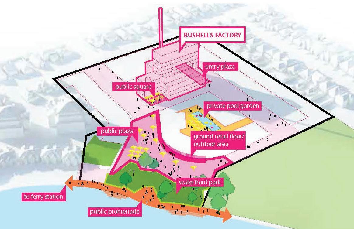
The revised Concept Plan comprises:  Retention of the Former Bushells Factory Central Roasting Hall building;  Approximately 400 new dwellings in the form of shop top housing, residential flat buildings and multi unit dwellings, ranging in height from 3 storeys (12m) to 6 storeys (21m), including the adaptive re-use of the existing Central Roasting Hall factory building;  Approximately 5,900m2 of public open space in the form of a new plaza and foreshore park  Approximately 7,000m2 of retail and commercial uses;  Approximately 3,000m² of urban service / light industry uses;  Car parking spaces over 2 levels of basement parking (or as required);  New local road linking Burwood Road to Zoeller Street; and  Bicycle and pedestrian access to the foreshore. The Concept Plan utilises the single ownership of the 3.9ha site to provide for an arrangement of uses more suited and consistent with the local area than currently exists. Figure 12 shows some of the potential activities that may occur as proposed by the revised Concept Plan. These improvements will enhance the appeal of the site and peninsula and will likely stimulate additional investment activity and land value in the locality. It will also assist in reducing the length of journeys to access local retail and services for residents in the peninsular locality.

Figure 12: Concept Plan - Potential Activities (Source: Roberts Day)

160 Burwood Road, Concord Bushells Redevelopment - Amended Planning Proposal v5-1 | LFA (Pacific) Pty Ltd

39


Turn static files into dynamic content formats.

Create a flipbook

Articles inside

Table 7: Canada Bay Local Strategic Planning Statement

30min
pages 71-91

Part 6 – Project Timeline

6min
pages 109-112

Table 9: Consistency with relevant Section 9.1 Directions

28min
pages 93-106

Table 8: Consistency with relevant SEPPs

1min
page 92

Table 6: Consistency with Canada Bay Local Planning Strategy 2010-2031

3min
pages 69-70

Table 5: Summary Strategic Merit Assessment

1min
page 68

Table 4: Consistency with the Eastern City District Plan

4min
pages 65-67

Figure 28: Proposed Foreshore Building Line Map

2min
pages 53-54

Figure 17: Public Realm (Source: Roberts Day

1min
page 46

Figure 13: Proposed Public Domain and private open space (Source AJ+C /BVN

1min
page 42

Figure 12: Concept Plan - Potential Activities (Source: Roberts Day

1min
page 41

Figure 15: Access and Movement (Source: Roberts Day

1min
page 44

Figure 16: Urban Structure (Source: Roberts Day

0
page 45

Part 1 – Objectives or Intended Outcomes

2min
page 39

Figure 9: CBLEP2013 Heritage Map

11min
pages 33-38

Executive Summary

14min
pages 7-13

1.3 Supporting Documentation

1min
page 20

1.2 Structure of the Report

1min
page 19

2.3 Surrounding Development

1min
page 24

3.1 Strategic Planning Context

6min
pages 25-27

Figure 5: LSPS Structure Plan

4min
pages 28-29

1.1 Background

12min
pages 14-18

Figure 6: CBLEP 2013 Land Zoning Map

1min
page 31
Issuu converts static files into: digital portfolios, online yearbooks, online catalogs, digital photo albums and more. Sign up and create your flipbook.