160 Burwood Rd Concord Amended PP v5

Page 46

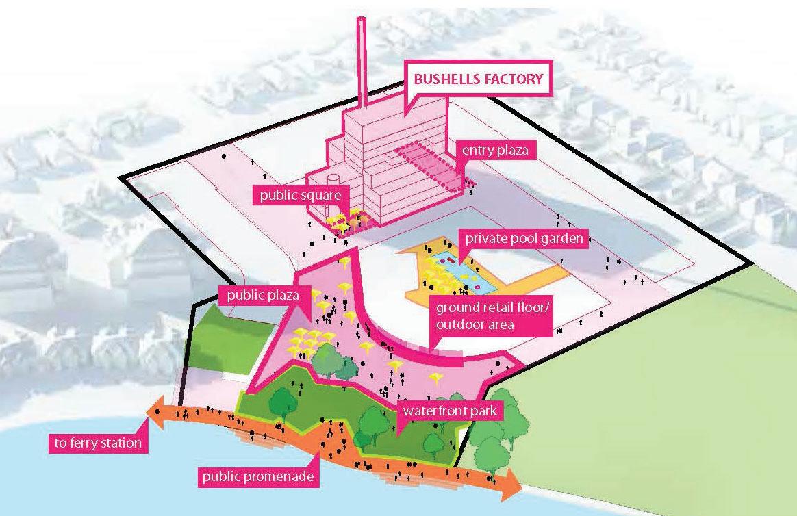
Public Realm An abundance of public space is a key public benefit of the Concept Plan. The plan focuses on providing public open space to create a positive visual impact to the locality and create an important community and civic focal point in Exile Bay. A series of public use locations closely integrated within the site and surrounds will enable the combined public spaces to become a local destination with high amenity, complementing the existing natural and urban context. Activated spaces towards the foreshore will create various settings for social and cultural connectedness, well-being and community relationships which may include community markets, events and festivals.

Figure 17: Public Realm (Source: Roberts Day)

Open Space and Tree Retention Retaining and enhancing the landscape character of the site is proposed through:  Creating a public park on the foreshore of Exile Bay to provide a recreation space as part of the Hen and Chicken Bay Foreshore Green Grid corridor.  Retaining the mature groves of trees along the eastern and western boundaries to maintain the existing developed landscape and privacy for neighbours.  Providing a public open space connecting the foreshore to the industrial character and retail and commercial service use.  Defining streets with strong landscape elements and minimum 25% tree canopy cover. The proposed open space will encourage and support community interactions and social cohesion by connecting with existing public foreshore access and adjoining open space.

44

160 Burwood Road, Concord Bushells Redevelopment - Amended Planning Proposal v5-1 | LFA (Pacific) Pty Ltd


Turn static files into dynamic content formats.

Create a flipbook

Articles inside

Table 7: Canada Bay Local Strategic Planning Statement

30min
pages 71-91

Part 6 – Project Timeline

6min
pages 109-112

Table 9: Consistency with relevant Section 9.1 Directions

28min
pages 93-106

Table 8: Consistency with relevant SEPPs

1min
page 92

Table 6: Consistency with Canada Bay Local Planning Strategy 2010-2031

3min
pages 69-70

Table 5: Summary Strategic Merit Assessment

1min
page 68

Table 4: Consistency with the Eastern City District Plan

4min
pages 65-67

Figure 28: Proposed Foreshore Building Line Map

2min
pages 53-54

Figure 17: Public Realm (Source: Roberts Day

1min
page 46

Figure 13: Proposed Public Domain and private open space (Source AJ+C /BVN

1min
page 42

Figure 12: Concept Plan - Potential Activities (Source: Roberts Day

1min
page 41

Figure 15: Access and Movement (Source: Roberts Day

1min
page 44

Figure 16: Urban Structure (Source: Roberts Day

0
page 45

Part 1 – Objectives or Intended Outcomes

2min
page 39

Figure 9: CBLEP2013 Heritage Map

11min
pages 33-38

Executive Summary

14min
pages 7-13

1.3 Supporting Documentation

1min
page 20

1.2 Structure of the Report

1min
page 19

2.3 Surrounding Development

1min
page 24

3.1 Strategic Planning Context

6min
pages 25-27

Figure 5: LSPS Structure Plan

4min
pages 28-29

1.1 Background

12min
pages 14-18

Figure 6: CBLEP 2013 Land Zoning Map

1min
page 31
Issuu converts static files into: digital portfolios, online yearbooks, online catalogs, digital photo albums and more. Sign up and create your flipbook.