SPRING 2016
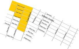
Residential Development Historic Ownership When the City of Brooklyn was incorporated in 1834, nine families owned the land comprising Boerum Hill. The Gerritsen and Martense families, who were related by marriage, owned the land within the boundaries of the designated Boerum Hill Historic District and its surrounding areas. The present State, Smith, Warren and Bond Streets roughly bounded Samuel Gerritsen’s property, while George Martense’s estate extended from State to Baltic Streets, and from Bond to Nevins Streets During the subsequent Federal period, Cobble Hill belonged to prosperous farm lords, who constructed country mansions on vast tracts of land that inclined westward East River. A principal force in the development westward from Cobble Hill to Boerum Hill was Charles Hoyt. He overcame resistance to initiate the first subdividing streets south from Brooklyn Heights to build up Cobble Hill (Hicks and Henry Streets). In alliance with R.H. Nevins and the Gerritsen and Martense families, Boerum Hill began to subdivide in 1835 Speculative Development It was a few years before speculative row houses began construction in Boerum Hill after the land subdivision by the Gerritsen and Martense families in 1835, but a great boom in the early 1850s populated the entire area. By 1840, a tax list and street directory presented 45 houses and 112 residents in Cobble Hill. A building boom, particularly with the construction of row houses, started to transform the study area into an urban community. Row houses were typically built individually or in rows, ranging anywhere from three houses to groups which occupied half a city block.1 At the end of the 1840s, construction began in Boerum Hill in the Historic District, in its northern section along Pacific and Dean Streets.
Map outlining the Patchen, Heeney, Gerritsen and Martense family tracts of land in 1834 Source: student-created infographic
City water didn’t arrive to the study area until the 1850s. Despite this speculative building and property acquisitions by affluent English, German, and second-generation American residents continued at a rapid pace. Industrial pollution from the factories along Bergen Street was documented, as well as frequent outbreaks of cholera and yellow fever. Into the 1860s a more diverse socioeconomic population brought racial and religious riots, particularly between Irish and German immigrants. Atlantic Avenue, the main commercial street through the study area, first rose to prominence during the Civil War, 18601864, when shipping activity along the Brooklyn waterfront became vital and integral to supply troops and supplies south to troops. By 1860, Cobble Hill had developed into a community, complete with a bank, stores and other services, including religious and institutional structures. The buildings along Bergen and Wyckoff Streets in the Boerum Hill Historic District were constructed after the Civil War, at the end of the 1860s and early 1870s. At the turn of the century, the demographic character of the community changed with the influx of immigrants from Ireland, Italy, Syria, and Germany. The town houses became multi-family dwellings, but the substantial exteriors of the structures remained essentially unaltered.2
Map outlining the subdivisions of land in 1835 Source: 1866 Johnson Map of New York City and Brooklyn
32 Architectural Development


