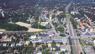
OLIVA (ES) PROJECT SCALE — XL/L – territory / urban + architecture
SITE PROPOSED BY — Community of Valencia,
LOCATION — Els Rajolars, Oliva, Valencia
City Council and Oliva City Council
POPULATION — 25,789 inhab.
OWNER OF THE SITE — Private ownership
STRATEGIC SITE — 229.46 ha / PROJECT SITE — 17.73 ha
POST-COMPETITION PHASE — Viability strategic plan
CITY OF OLIVA — 1. WHAT ARE THE GOALS OF THE SITE MUTATION?
The overall goal is to regain the initiative in planning and management and to debate innovative ideas about generating new urban dynamics, because we need to propose a new city model that considers: sustainability, respect for our heritage, diversification of compatible uses, citizen participation, non-motorized mobility, appropriate governance of the system and innovation based on professional training. The specific goal is the resilient regeneration of the study area with a view to the transformation of its degradation. 2. HOW CAN THE SITE BE INTEGRATED IN THE ISSUES OF PRODUCTIVE CITIES? HOW DO YOU CONSIDER THE PRODUCTIVITY ISSUE?
This is an area with a powerful productive heritage, evidenced by the remaining traces of its past and its latent production. The initial goal is to implement a sustainable production model based on the circular economy, that is compatible with residential uses and has a modern language that draws in and develops 192
key production sectors while maintaining its essence —ceramic production, tourism, water management, food and agriculture—, yet without striving to return to the past. The installation of a high-performance job training centre will help to achieve these goals primarily in these sectors and with productivityfocused innovation, as well as an offer of new formulas for their development. 3. HAVE YOU ALREADY DEFINED A SPECIFIC PROCESS FOR THE URBAN AND/OR ARCHITECTURAL DEVELOPMENT OF THE SITE AFTER EUROPAN COMPETITION?
In the light of the winning project, we are studying the extension of the commission to include the draft of a masterplan, which will mark the elements to maintain and reuse as infrastructure and facilities, accompanied by a Special Urban Land Reform Plan, which will set out the details of the urban planning property rights, the new public infrastructure and facilities, and define the road grid. It might also cover the Property Redistribution Project and the Urban Development of the Unit containing “La Salvaora”, which may serve as an exemplary “pilot case” for the management of the area as a whole.


